
Features a gorgeous depiction of the Amazon River Basin.
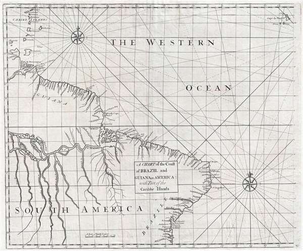
A Chart of the Coast of Brazil and Guiana in America : with Part of the Caribbe Islands
$525.00
Acquire
- Digital Map Information
- Suitable for large format printing
- DPI: 300
- File Size: 10.97 MB
- File Type: ZIP / TIFF
- ICC color profile embedded
- Delivered instantly via download link
This is a 1728 John Senex and Edmond Halley map of Brazil and Guiana. The map depicts the coast of South America from the mouth of the Orinoco (Oronoque) River to All Saint's Bay / Baia de Todos os Santos (labeled as Bay Todos Santos) and Salvador, Brazil and from ... (more details)
Employs a mountain range to separate the Amazon and Paraguay Rivers - unlike most other maps of South America from this era.
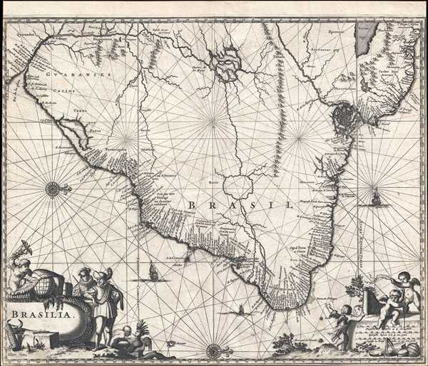
Brasilia.
sold
- Digital Map Information
- Suitable for large format printing
- DPI: 300
- File Size: 5.85 MB
- File Type: ZIP / TIFF
- ICC color profile embedded
- Delivered instantly via download link
This is a 1671 Arnoldus Montanus map of Brazil. Oriented toward the west, the map depicts the region from the Rio de la Plata to Guiana and the Atlantic Ocean and from two mythical lakes (Lake Parima and Lake Xarayes) to the Atlantic Ocean. As was common for maps ... (more details)
Scottish Pre-WWII flag chart with Third Reich flags.

Brown's Flags of All Nations.
sold
- Digital Map Information
- Suitable for large format printing
- File Size: 16.1 MB
- File Type: ZIP / TIFF
- ICC color profile embedded
- Delivered instantly via download link
This is Brown, Son and Ferguson's c. 1934 chart of the flags of all nations. A dramatic large format chart illustrating the flags of the world's maritime nations with a focus on the British Empire and its various extensions. The chart is divided into four primary sections. The upper section focuses on the British Empire, featuring flags from England, Scotland, Ireland, and various British military, commercial, government and postal carriers. Below this there are a series of flags and badges associated with colonies, dominions, protectorates, dependencies and mandated states. These include India, Hong Kong, Gibraltar, the Falklands, the Unfederated Malay States, New Zealand, Canada, and more. In addition to proper flags, there are also a series of badges medallions that were added to the Union Jack to identify client states. Foreign flags and ensigns appear below. Among these are the flags of the United Sates, 'Koweit', Korea, Japan, Colombia, the Papal States, the Soviet Union, and more. Germany has four flags, all bearing the swastika, firmly dating this chart to the pre-war period of the German Third Reich, roughly 1933 to 1939. (more details)
One of the rarest and most desriable U.S. Coast Survey maps of the Chesapeake Bay.

General Chart of Delaware and Chesapeake Bays and the Sea Coast from Cape May to Cape Henry.
sold
- Digital Map Information
- Suitable for large format printing
- File Size: 26.96 MB
- File Type: ZIP / TIFF
- ICC color profile embedded
- Delivered instantly via download link
An extraordinary 1866 U.S. Coast Survey nautical chart or maritime map of the Chesapeake Bay and Delaware Bay. This is one of the rarest and most desirable charts issued by the U.S. Coast Survey. The map depicts from Norfolk, Virginia and Cape Henry north to ... (more details)
Labels Albany, Louisiana - 'A shipping point of some note' in 1860.
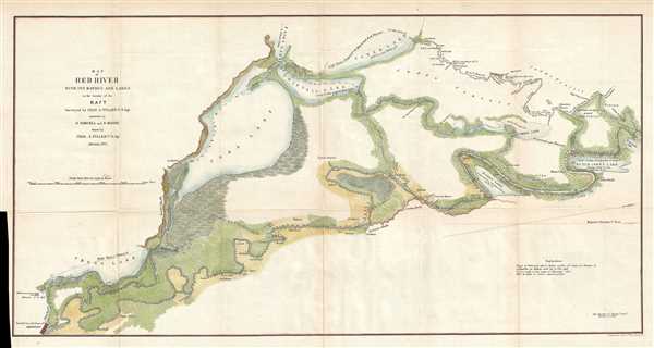
Map of Red River with its Bayous and Lakes in the vicinity of the Raft.
sold
- Digital Map Information
- Suitable for large format printing
- File Size: 5.35 MB
- File Type: ZIP / TIFF
- ICC color profile embedded
- Delivered instantly via download link
This is a large 1855 Land Survey map following the course of the Red River from Shreveport, Louisiana to its confluence with the Red Bayou. It was drawn by Charles A. Fuller to illustrate his travels on and inspection of the Red River. Using a simple raft, ... (more details)
Illustrates how land was surveyed in the State of Michigan.
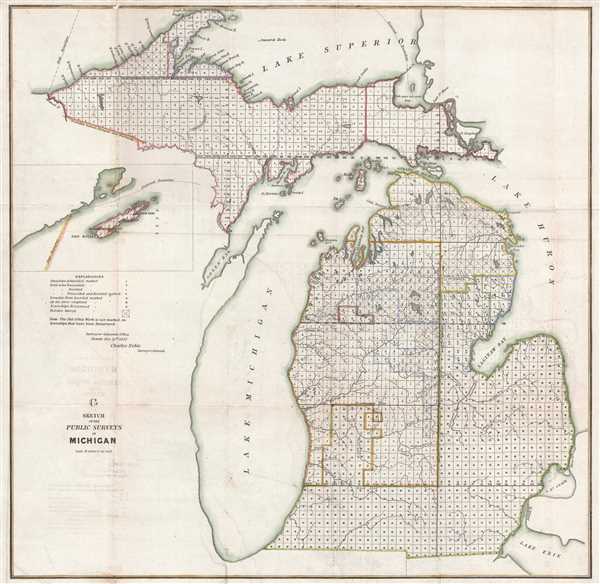
G Sketch of the Public Surveys in Michigan.
sold
- Digital Map Information
- Suitable for large format printing
- DPI: 300
- File Size: 12.46 MB
- File Type: ZIP / TIFF
- ICC color profile embedded
- Delivered instantly via download link
This is an 1852 Charles Noble land survey map of Michigan. The map depicts the state from Lake Superior to Lake Erie, Ohio, Indiana, and Illinois and from Wisconsin to Lake Huron. Illustrating the current status of the land survey in Michigan, each township ... (more details)
Beautiful nautical chart of Beautfort Harbor in North Carolina.

D No.5 Preliminary Sketch of Beaufort Harbor North Carolina.
sold
- Digital Map Information
- Suitable for large format printing
- DPI: 300
- File Size: 5.05 MB
- File Type: ZIP / TIFF
- ICC color profile embedded
- Delivered instantly via download link
This is a beautiful example of the 1851 U. S. Coast Survey's nautical chart of Beaufort Harbor in North Carolina. The map depicts from the town of Beaufort south to the Shackleford Banks and includes parts of Carrot Island and Bogue Island. Superb inland ... (more details)
Highlights improvements for travelers between New York City and Boston following the opening of the Stonington Line.

Rhode Island.
sold
- Digital Map Information
- Suitable for large format printing
- DPI: 300
- File Size: 5.24 MB
- File Type: ZIP / TIFF
- ICC color profile embedded
- Delivered instantly via download link
This is an 1846 Thomas G. Bradford map of Rhode Island. The map depicts the state in its entirety, from Connecticut to Massachusetts and from Massachusetts to the Atlantic Ocean and Block Island. Featuring the route of the New York, Providence, and Boston ... (more details)
Features early county configuration. Predates West Virginia.
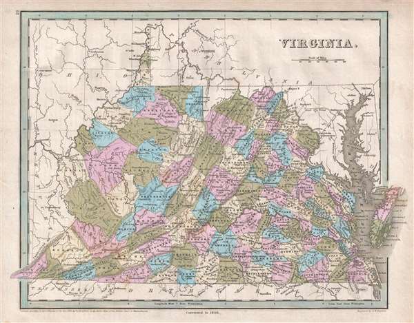
Virginia.
sold
- Digital Map Information
- Suitable for large format printing
- DPI: 300
- File Size: 5 MB
- File Type: ZIP / TIFF
- ICC color profile embedded
- Delivered instantly via download link
This is an 1846 Thomas G. Bradford map of Virginia and West Virginia. The map depicts the region from Ohio and Kentucky to the Chesapeake Bay and from Pennsylvania and Ohio to Tennessee and North Carolina. Highly detailed, each county is labeled and ... (more details)
China on the brink of the Taiping Rebellion.
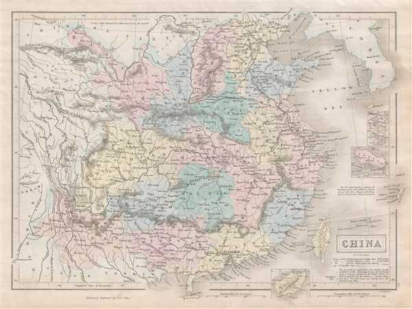
China.
sold
- Digital Map Information
- Suitable for large format printing
- DPI: 300
- File Size: 4.46 MB
- File Type: ZIP / TIFF
- ICC color profile embedded
- Delivered instantly via download link
This is an 1851 Adam and Charles Black map of China. The map depicts China from Chinese Tartary to Hainan and from Assam in India to Korea (Corea), inclusive of Formosa or Taiwan. Four inset maps detail Amoy, Hong Kong, ZhouShan and Hainan. The ... (more details)
Navigational chart of Frying Pan Shoals - famous for its shipwrecks!
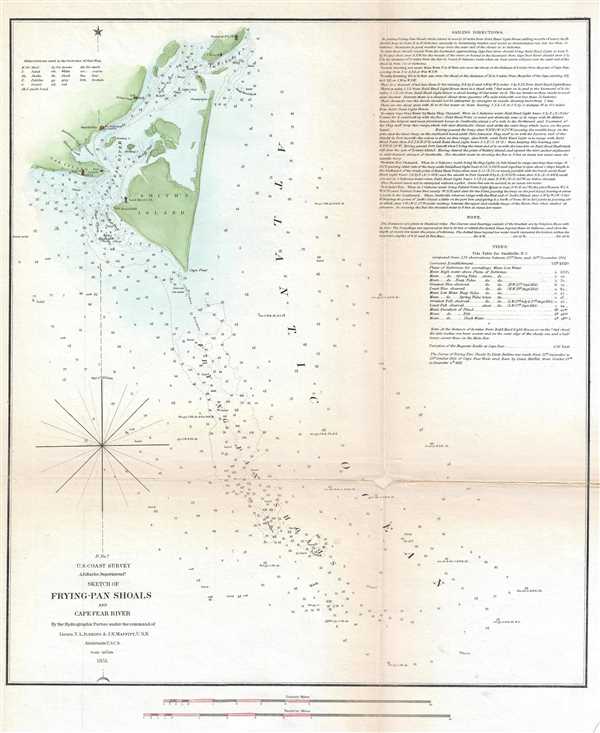
Sketch of Frying-Pan Shoals and Cape Fear River.
sold
- Digital Map Information
- Suitable for large format printing
- DPI: 300
- File Size: 2.84 MB
- File Type: ZIP / TIFF
- ICC color profile embedded
- Delivered instantly via download link
This is an 1851 U. S. Coast Survey nautical chart or maritime map of the Frying Pan Shoals and the Cape Fear River in North Carolina. The chart depicts from the Federal Point Lighthouse on the southern tip of Pleasure Island to the Frying Pan ... (more details)
The Blue Map of China - one of the most important and beautiful maps ever made.
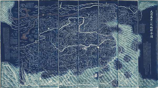
DaQing Wannian Yitong Tianxia Quantu / 大清万年一统天下全图 / All-Under-Heaven Complete Map of the Everlasting Unified Qing Empire
sold
- Digital Map Information
- Suitable for large format printing
- Full resolution TIFF file
- ICC color profile embedded
- Delivered instantly via download link
The legendary Blue Map of China under the Great Qing, one of the rarest, largest, and most aesthetically magnificent Chinese maps ever made. Published in 1811 (Jiaqing 16) in the Qing Dynasty, this Chinese map by Huang Qianren (黃千人, 1694–1771) is of utmost significance. Although ostensibly a map of China, the coverage of this map in fact extends to all lands touched by the influence Qing Empire, including England, Holland, Southeast Asia, Arabia, and Africa. As such it can be considered a political manifesto lionizing the unity and majesty of Qing China as well as a functional administrative document. (more details)
An highly influential and often under appreciated map. Second American commercial map published as a foreign National Map. Map that led to the bankruptcy of the Colton firm and contributed to the rise of the Johnson firm.
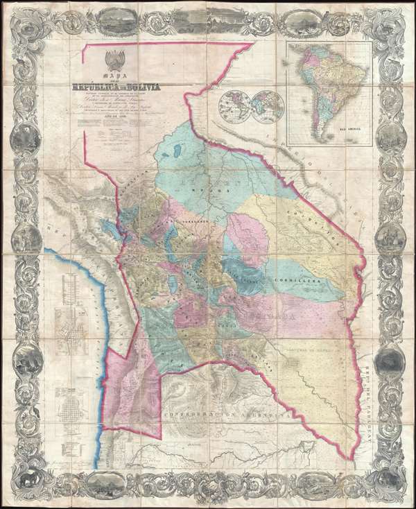
Mapa de la Republica de Bolivia mandado publicar pr el Gobierno de la Nacion en la Administracion del Presidente Doctor José Maria Linares... Levantado y organindo en los años de 1842 à 1859 Por el Teniente Coronel Juan Ondarza, Commandante Juan Mariano Mujia y Mayor Lucio Camacho.
sold
- Digital Map Information
- Suitable for large format printing
- File Size: 91.32 MB
- File Type: ZIP / TIFF
- ICC color profile embedded
- Delivered instantly via download link
A magnificent and important map of extreme and often underappreciated multilevel significance; this is J. H. Colton and Juan Ondarza Lara's great national map of Bolivia. This map is highly significant and influential on a number of ... (more details)
Important map reafirming Qing Unity and dominance following Jahangir's Holy War on the Turkestan Frontier.

清朝一統之圖 / The unification of the Qing Dynasty. / Shinchō ittō no zu. / Chōi ichiran.
sold
- Digital Map Information
- Suitable for large format printing
- DPI: 300
- File Size: 22.29 MB
- File Type: ZIP / TIFF
- ICC color profile embedded
- Delivered instantly via download link
A 天保 Tenpō 6 map of China under the Qing Dynasty, covering from India to Japan, inclusive of all of China and Korea, reflecting a pan-Buddhist perspective. The Great Wall is evident at the top of the map and in fact forms part of the ... (more details)
Enormous World War II map of the Philippines.
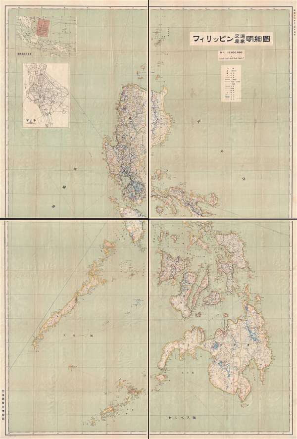
フィリッピン交通產業明細圖 / Philippines Detailed Traffic and Industry Map.
sold
- Digital Map Information
- Suitable for large format printing
- File Size: 62.52 MB
- File Type: ZIP / TIFF
- ICC color profile embedded
- Delivered instantly via download link
An important November 15, 1941 (Showa 16) wall map of the Philippines published by the Taiwan Governor's Office intelligence division on the day the Southern Expeditionary Army (南方軍) confirmed its plans to invade the archipelago. The December 1941 invasion of the Philippines followed shortly thereafter. As such, this is arguably one of the most important Japanese maps of the Philippines published in the 20th century.
The focus of the map is the Philippine transportation network. The level of detail evident in this map illustrates the extreme interest the Japanese had in the Philippines, not only as a source of personnel and resources, but as a steppingstone to Southeast Asia and Melanesia. (more details)
The focus of the map is the Philippine transportation network. The level of detail evident in this map illustrates the extreme interest the Japanese had in the Philippines, not only as a source of personnel and resources, but as a steppingstone to Southeast Asia and Melanesia. (more details)
Depicts the Republic of Texas and Texas at its largest in manuscript.

North America.
sold
- Digital Map Information
- Suitable for large format printing
- DPI: 300
- File Size: 4.96 MB
- File Type: ZIP / TIFF
- ICC color profile embedded
- Delivered instantly via download link
This is an 1846 Thomas Bradford map of North America. The map depicts the continent from the Arctic Ocean to northern South America (Colombia, Venezuela) and from the Pacific Ocean to the Atlantic Ocean. Several remarkable and ephemeral ... (more details)
Illustrates and labels two Spanish land grants honored by the United States government.
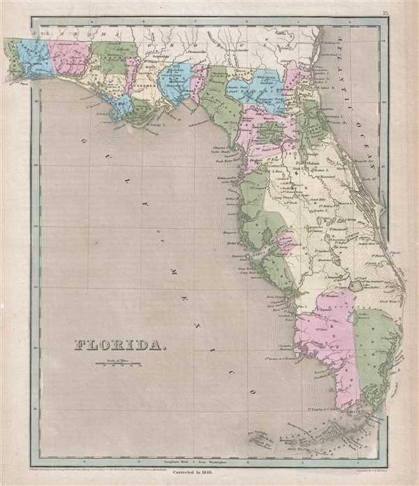
Florida.
sold
- Digital Map Information
- Suitable for large format printing
- DPI: 300
- File Size: 5.39 MB
- File Type: ZIP / TIFF
- ICC color profile embedded
- Delivered instantly via download link
This is an 1846 Thomas Bradford map of Florida. The map depicts the state from Georgia and Alabama to the Florida Keys and from the Perdido River to Jupiter Island and the area that is occupied by Palm Beach today. Florida is divided ... (more details)
Depicts Willamsburg, Brooklyn, and New York when they were separate cities.
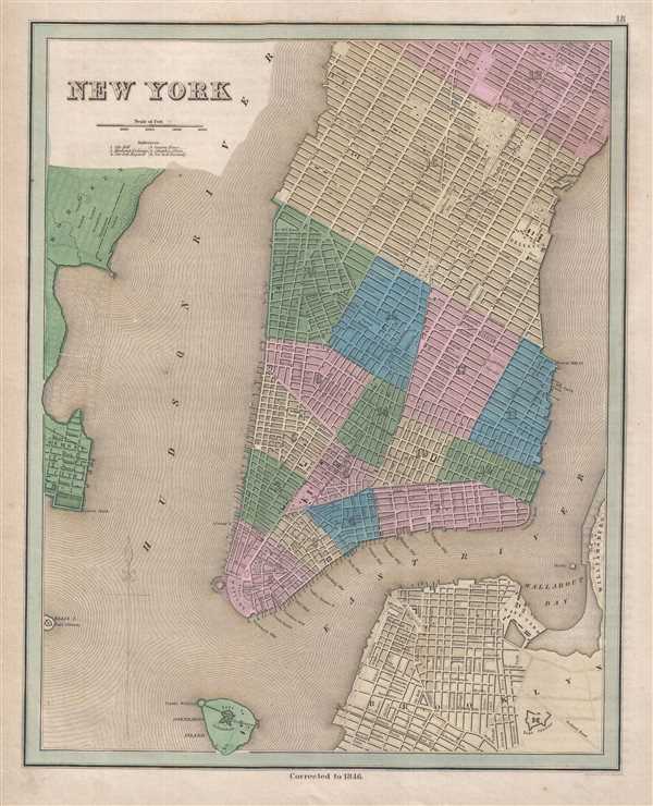
New York.
sold
- Digital Map Information
- Suitable for large format printing
- DPI: 300
- File Size: 7.25 MB
- File Type: ZIP / TIFF
- ICC color profile embedded
- Delivered instantly via download link
This is an 1846 Thomas Bradford city map or plan of New York City. The map depicts the region from Hoboken, New Jersey to the East River and Williamsburg and from Fifty-Third Street to Brooklyn and Governor's Island. At this point in ... (more details)
Exceptional map of Boston on the cusp of its landfill transformation into a modern metropolis.

Boston.
sold
- Digital Map Information
- Suitable for large format printing
- DPI: 300
- File Size: 5.99 MB
- File Type: ZIP / TIFF
- ICC color profile embedded
- Delivered instantly via download link
A beautiful example of Thomas G. Bradford's stunning 1846 map of Boston on the cusp of its transformation, via landfills and railroads, from a colonial port to a major metropolitan center. The cartographer uses shading to indicate ... (more details)
Allows for some insight into how Wisconsin was settled.
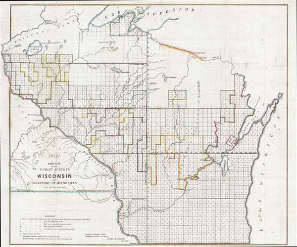
No. 1. Sketch of the Public Surveys in Wisconsin and Territory of Minnesota.
sold
- Digital Map Information
- Suitable for large format printing
- DPI: 300
- File Size: 7.77 MB
- File Type: ZIP / TIFF
- ICC color profile embedded
- Delivered instantly via download link
This is an 1852 George Sargent map of Wisconsin. The map depicts the region from Lake Superior to the Wisconsin-Illinois border and from Minnesota and Iowa to Lake Michigan, Green Bay, and Michigan's Upper Peninsula. Created four ... (more details)