
Mitchell's map of Ontario, Canada featuring Lake Superior.

Canada West formerly Upper Canada.
sold
- Digital Map Information
- Suitable for large format printing
- DPI: 300
- File Size: 8.95 MB
- File Type: ZIP / TIFF
- ICC color profile embedded
- Delivered instantly via download link
This is an attractive 1849 example of the legendary American map publisher Samuel Augustus Mitchell’s map of the Canadian province of Ontario, or Canada West. Centered on Lake Ontario, this map covers from Lake Erie eastward from Detroit, Michigan and Lake Huron ... (more details)
Lovely map of North America.
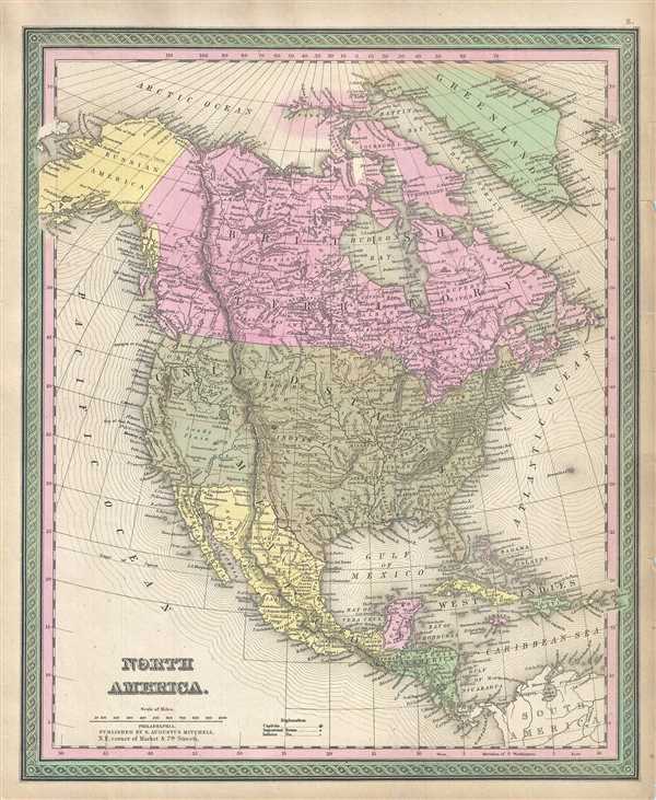
North America.
sold
- Digital Map Information
- Suitable for large format printing
- DPI: 300
- File Size: 9.55 MB
- File Type: ZIP / TIFF
- ICC color profile embedded
- Delivered instantly via download link
This attractive 1849 map by Samuel Augustus Mitchell depicts North America. Shows the entire continent along with Greenland, Central America, United States, Canada, and the West Indies. Various important cities, rivers, islands, mountain ranges, and several other ... (more details)
The world on a globular projection.

A New Map of the World on the Globular Projection.
sold
- Digital Map Information
- Suitable for large format printing
- DPI: 300
- File Size: 5.26 MB
- File Type: ZIP / TIFF
- ICC color profile embedded
- Delivered instantly via download link
This is a lovely hand colored map of the world on a globular projection by Samuel Augustus Mitchell dating to 1849. It depicts the world on hemispherical projection and offers a fascinating snapshot of the world during a period of rapid globalization and ... (more details)
Uncommon flag chart showing the flag for the Republic of Texas.
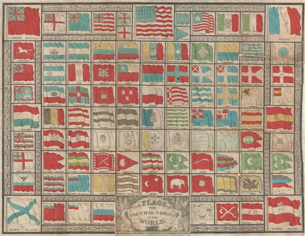
The Flags of the Principal Nations in the World.
sold
- Digital Map Information
- Suitable for large format printing
- DPI: 300
- File Size: 9.33 MB
- File Type: ZIP / TIFF
- ICC color profile embedded
- Delivered instantly via download link
A beautiful 1837 flag chart issued by R. L. Barnes including the martime ensign of the Republic of Texas. The chart features a total of 98 flags associated with countries in Asia, Africa, America, and Europe. In some cases, both merchant and naval ensigns are included. The chart also includes the ensigns of merchant companies, including the British East India Company and the Russian-American Company. (more details)
Impressive pictorial map illustrating the history of England and Wales.
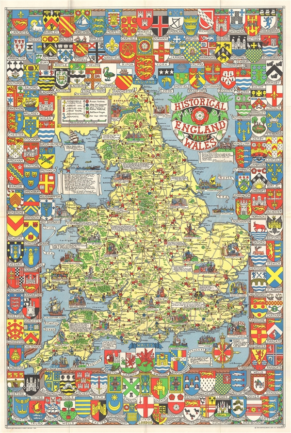
Historical Map of England and Wales.
sold
- Digital Map Information
- Suitable for large format printing
- File Size: 34.7 MB
- File Type: ZIP / TIFF
- ICC color profile embedded
- Delivered instantly via download link
A wonderful large 1963 format pictorial map illustrating the history of England and Wales drawn by Leslie Bullock. The map coves all of England and Scotland with historical locations and events illustrated pictorially in the form of charming cartoon ... (more details)
Wonderfully decorative vacationer's map of New England.

Summer Resorts of the Coast, Lake and Mountain Regions along the Boston & Maine Railroad and Connections.
sold
- Digital Map Information
- Suitable for large format printing
- Full resolution TIFF file
- ICC color profile embedded
- Delivered instantly via download link
A wonderfully decorative 1912 map of New England issued by the Matthews-Northrup company. The map covers from New York City northwards along the Atlantic coast as far as New Brunswick and the Gulf of Saint Lawrence; and from the Hudson River Valley to ... (more details)
Uncommon nautical chart detailing Miami Beach, South Beach.
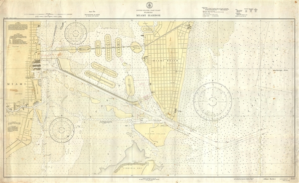
United States - East Coast Florida Miami Harbor. No. 547.
sold
- Digital Map Information
- Suitable for large format printing
- File Size: 17.69 MB
- File Type: ZIP / TIFF
- ICC color profile embedded
- Delivered instantly via download link
This is a scarce 1936 U.S. Coast and Geodetic Survey nautical chart or maritime map of Miami South Beach. This map is unusual in that it covers the southern portion of Miami Beach from about 24th Street, currently called South Beach, an ultra-hip ... (more details)
Scarce map of Istanbul printed in Istanbul.

Plan general de la ville de Constantinople. Feuille 1: Stamboul.
sold
- Digital Map Information
- Suitable for large format printing
- File Size: 23.03 MB
- File Type: ZIP / TIFF
- ICC color profile embedded
- Delivered instantly via download link
A scarce 1922 Turkish issue map of Istanbul or Constantinople, Turkey, issued by the Société Anonyme Ottomane D'Études et D'Enterprises Urbaines. The map covers the Fatih or Sultanahmet districts commonly known as the 'Golden Horn.' Detail ... (more details)
Exceptional and very rare Lafreri school map of Africa!
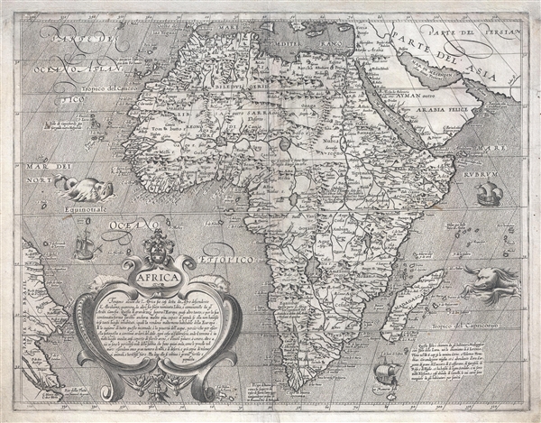
Africa.
sold
- Digital Map Information
- Suitable for large format printing
- DPI: 300
- File Size: 11 MB
- File Type: ZIP / TIFF
- ICC color profile embedded
- Delivered instantly via download link
An extremely rare separately issued c. 1600 Lafreri school map of Africa by Fiamengo Arnoldo di Arnoldi. Arnoldi's map covers the continent of Africa in full, as well as parts of the adjacent Arabian Peninsula (modern day Saudi Arabia), and ... (more details)
The first specific map of the west to appear in an American Atlas. Also, the only edition of this map to show the California Gold Region.

Oregon, Upper California, and New Mexico.
sold
- Digital Map Information
- Suitable for large format printing
- DPI: 300
- File Size: 6.18 MB
- File Type: ZIP / TIFF
- ICC color profile embedded
- Delivered instantly via download link
One of the most important mid-19th century American Atlas maps ever published, this is Samuel Augustus Mitchell's 1849 map of Upper California and Oregon, with a highlighted gold region. The map covers from Vancouver to the Mexico border ... (more details)
The lunar theories of Claudius Ptolemy in stunning old color.

Theoria Lunae, eius Motum per Eccentricum et Epicyclum Demonstrans.
sold
- Digital Map Information
- Suitable for large format printing
- DPI: 300
- File Size: 9.22 MB
- File Type: ZIP / TIFF
- ICC color profile embedded
- Delivered instantly via download link
A fine 1708 Andreas Cellarius celestial chart illustrating the Claudius Ptolemy model of lunar motion. The chart illustrates the lunar epicycles as the moon revolves along various orbits. The central chart is bordered zodiacal ... (more details)
Highly decorative first editon map of London with vingette advtising 'Wyld's Great Globe' in Leicester Square.
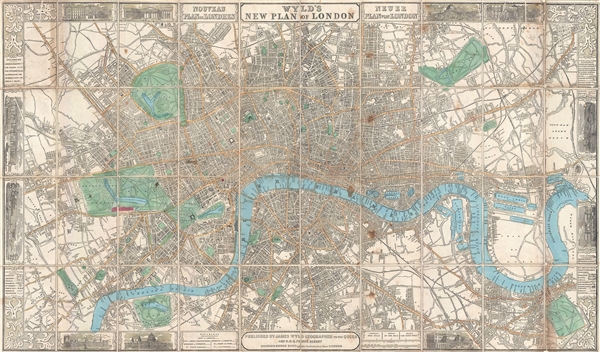
Wyld's New Plan of London.
sold
- Digital Map Information
- Suitable for large format printing
- File Size: 24.91 MB
- File Type: ZIP / TIFF
- ICC color profile embedded
- Delivered instantly via download link
A thoroughly decorate 1851 first edition plan or map of London, England by James Wyld. Centered on Blackfriars Bridge, the map coves central London from Islington to North Brixton and from the East India Docks to Holland Park. ... (more details)
Only known example of this map overprinted to illustrate the Cook-Peary North Pole discovery debate of 1909.
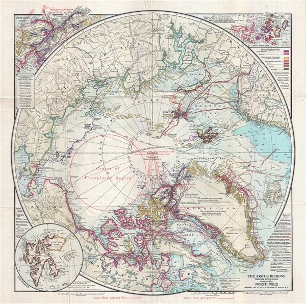
The Arctic Regions Showing Exploration towards the North Pole.
sold
- Digital Map Information
- Suitable for large format printing
- File Size: 11.25 MB
- File Type: ZIP / TIFF
- ICC color profile embedded
- Delivered instantly via download link
An extremely rare 1909 separately issued map of the Arctic showing exploratory routes towards the North Pole as of 1909. The map covers the Arctic regions as far south as Iceland and the Bearing Straits. The map is based upon ... (more details)
Map of Texas at its fullest extand issued just before the Comprimise of 1850.

Map of Texas from the most recent authorities.
sold
- Digital Map Information
- Suitable for large format printing
- DPI: 300
- File Size: 4.78 MB
- File Type: ZIP / TIFF
- ICC color profile embedded
- Delivered instantly via download link
A fine example of the scarce 1849 Samuel Augustus Mitchell Map of Texas. Based upon the Tanner/Burroughs map of 1847, this map covers all of Texas according to the original 1836 claims of the Republic of Texas. This includes ... (more details)
Only know example of this rare view of the Battle of Manila.

The Battle of Manila, May 1, 1898 -- After Breakfast.
sold
- Digital Map Information
- Suitable for large format printing
- File Size: 16.38 MB
- File Type: ZIP / TIFF
- ICC color profile embedded
- Delivered instantly via download link
The only known example of this 1898 chromolithograph view of the Battle of Manila – After Breakfast . The view shows the American Asiatic Squadron led by its Flagship, the Olympia, bombarding the Spanish Pacific Squadron ... (more details)
Munster's second map of Scandinavia, after Olaus.
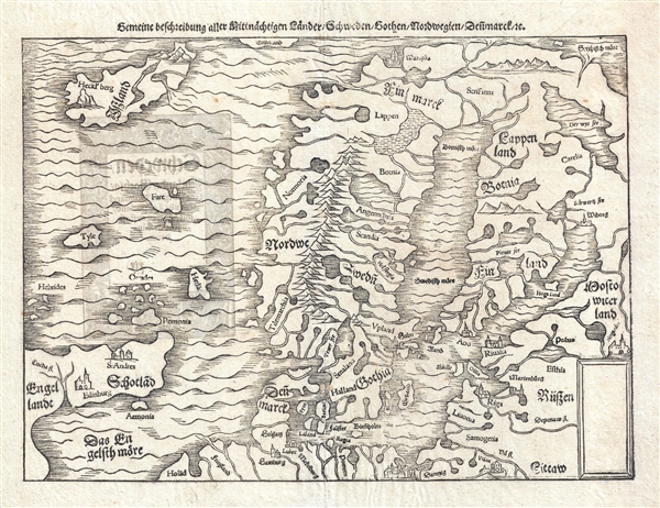
Gemeine Beschreibung Aller Mitnachtigen Lander Schweden, Gothen, Nordwegien, Dennmarck
sold
- Digital Map Information
- Suitable for large format printing
- DPI: 300
- File Size: 5.18 MB
- File Type: ZIP / TIFF
- ICC color profile embedded
- Delivered instantly via download link
An Uncommon 1574 Sebastian Munster Woodcut Map Of Scandinavia. The Map Covers Scandinavia From Iceland To Germany And From Edinburgh, Scotland, To (Roughly) The Modern Day Russian Border. It Includes The Modern Day Nations ... (more details)
One of the more attractive 19th century commercial atlas maps of New York City.

City of New York.
sold
- Digital Map Information
- Suitable for large format printing
- DPI: 300
- File Size: 7.39 MB
- File Type: ZIP / TIFF
- ICC color profile embedded
- Delivered instantly via download link
One of the more attractive atlas maps of New York to appear in the mid-19th century, this is a beautiful example of Samuel Augustus Mitchell's 1849 map of southern Manhattan. The map depicts southern Manhattan from 37th ... (more details)
Wonderful wine theme pictorial map of Portugal.

Portugal Wine Districts. Portugal Regiõnes Vinícolas. Portugal Weingegenden. Portugal Régions Vinicoles.
sold
- Digital Map Information
- Suitable for large format printing
- Full resolution TIFF file
- ICC color profile embedded
- Delivered instantly via download link
A very attractive 1959 pictorial oenological map of Portugal by Mário Costa promoting Portuguese Wines. The map covers all of Portugal with lavish illustrations in pastel tones emphasizing the various wine regions, ... (more details)
Rare pictorial map of the Gaspé Peninsula, Quebec by Maw.

[Gaspé Peninsula]
sold
- Digital Map Information
- Suitable for large format printing
- Full resolution TIFF file
- ICC color profile embedded
- Delivered instantly via download link
Rare 1929 Pictorial Map of the Gaspé Peninsula, Quebec, by the artist and architect Samuel Herbert Maw. Centered on the St. Lawrence River, the map cover from Quebec City to the Gulf of St. Lawrence. Towns and ... (more details)
Vivid map of Florida.
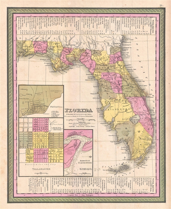
Florida.
sold
- Digital Map Information
- Suitable for large format printing
- DPI: 300
- File Size: 5.18 MB
- File Type: ZIP / TIFF
- ICC color profile embedded
- Delivered instantly via download link
A fine example of Samuel Augustus Mitchell's 1849 map of Florida. Mitchell's map covers the entire state in considerable detail with towns, cities, counties, swamps, and reefs noted. Water routes and their ... (more details)