
Highways of Florida.
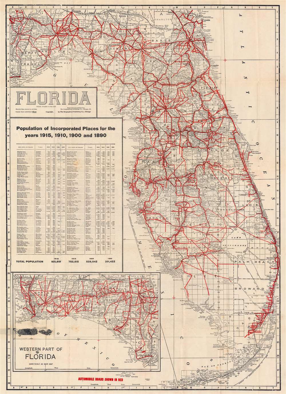
Florida.
sold
- Digital Map Information
- Suitable for large format printing
- Full resolution TIFF file
- ICC color profile embedded
- Delivered instantly via download link
This is a c. 1920 Geographical Publishing Company map of Florida highlighting the highway system. The map covers all of peninsular Florida with the west Florida panhandle appearing as an inset in the lower left. Red highlighting indicates the state's expansive highway system. Census statistics for 1890 through 1915 illustrate the extent to which Florida's population nearly tripled in just 25 years. The verso features an index of towns. (more details)
The great age of Radio.

Eagle's Eye View of Weber City.
sold
- Digital Map Information
- Suitable for large format printing
- File Size: 22.64 MB
- File Type: ZIP / TIFF
- ICC color profile embedded
- Delivered instantly via download link
This is a 1935 Amos 'n' Andy map of Weber City, a high-class housing development created for the Amos 'n' Andy radio show. All fictional, coverage extends from Amos Jones Alley to Van Porter Road and from the 'love nest were Mr. and Mrs. Andrew H. Brown is going to live' and 'Everybody's Church' to Weber Park and 'Bite-a-Minute Lake'. A comical look at a fictional town, Weber City evidently played a role in, or was the setting for, at least one Amos 'n' Andy radio show. (more details)
Promoting Bradenton, 'The Friendly City'.
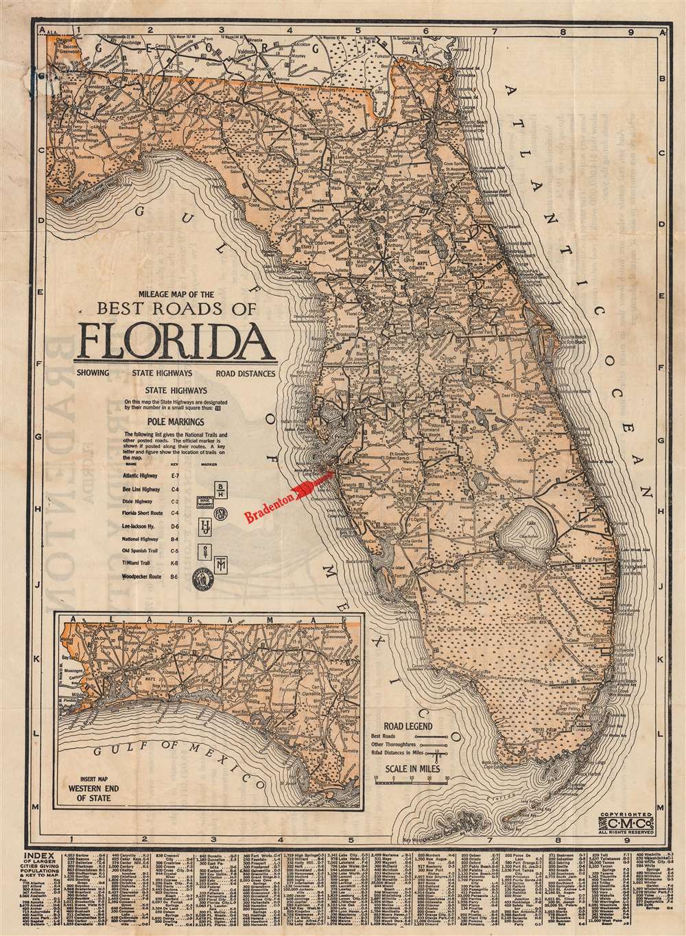
Milage Map of the Best Roads of Florida.
sold
- Digital Map Information
- Suitable for large format printing
- Full resolution TIFF file
- ICC color profile embedded
- Delivered instantly via download link
This is a c. 1922 Clason Map Company road map of Florida issued to promote real estate development in Bradenton, just south of Tampa. The map covers all of Florida, with the west Florida panhandle included via an inset. The map details major roadways throughout the state as well as roads under construction, such as Tamiami Trail across the Everglades from Miami. Just to the north is the Seminole Indian Reservation known as 'Big Cypress'. (more details)
First printed map of the Western Hemisphere.
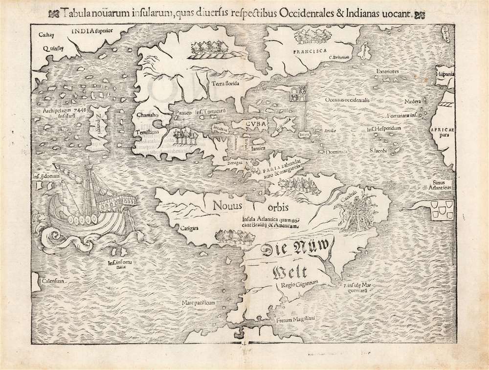
Tabula novarum insularum, quas diversis respectibus Occidentales et Indianas vocant.
sold
- Digital Map Information
- Suitable for large format printing
- Full resolution TIFF file
- ICC color profile embedded
- Delivered instantly via download link
This is an excellent 1552 Latin edition of Sebastian Münster's map of America, the first printed map of the Western Hemisphere. The map first appeared in Münster's 1540 edition of Ptolemy's Geographia, one of the earliest versions of the classical work to systematically include maps showing contemporary geographical knowledge. Beginning in 1544, it would be included in Münster's magnum opus, Cosmographia Universalis, which for over forty years was the primary source for anyone interested in world geography. Consequently, this map had a disproportionate impact, providing the first glimpse of the New World to Europeans for nearly half a century. (more details)
First Edition, First State.
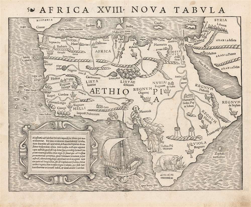
Africa XVIII. Nova Tabula.
sold
- Digital Map Information
- Suitable for large format printing
- Full resolution TIFF file
- ICC color profile embedded
- Delivered instantly via download link
This is the rare 1540 first edition of Sebastian Münster's map of Africa, the earliest detailed map of the continent available to the collector, here in its earliest state. As is to be expected for an early printing strike, the image is bold, sharp and clear. This attractive and evocative map was broadly influential: for more than thirty years during the age of discovery, this map would be the predominant representation of Africa available to the European reader. (more details)
A Circumnavigable Globe Revealed.
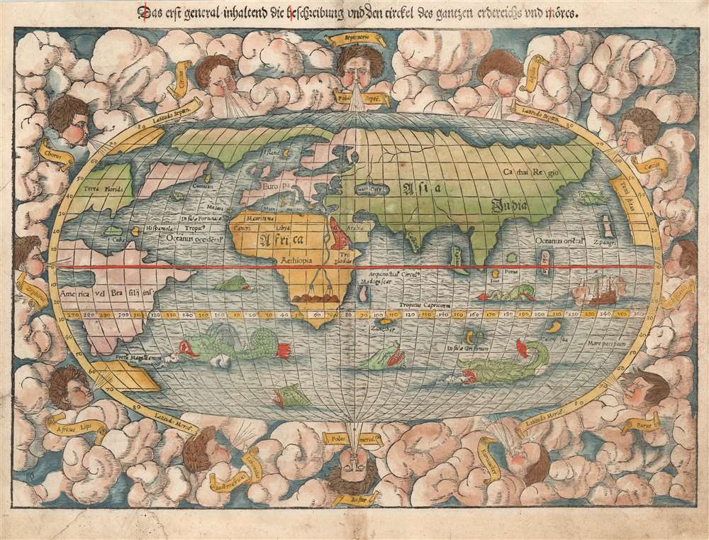
Das erst general, inhaltend die beschreibung und den circkel des gantzen erdtreichs und môres.
sold
- Digital Map Information
- Suitable for large format printing
- Full resolution TIFF file
- ICC color profile embedded
- Delivered instantly via download link
This is the first, 1550 German edition of the second block of Sebastian Münster's map of the world, one of the most distinctive to be produced during the Age of Discovery. In the mid-sixteenth century, it was the best summation of the rapidly-expanding known world available to the literate European. The map was included in Münster's magnum opus, Cosmographia Universalis, for over forty years was the primary source for anyone who wished knowledge of the world. Consequently, this map would have had a disproportionate impact, providing the first presentation of a circumnavigable world for nearly half a century. It would not be challenged until the 1570 publication of Ortelius' Theatrum Orbis Terrarum. As important as its geographical revelations were, the map is also rich in the imagery of its era: it is bordered with billowing clouds, with wind-heads marking the cardinal directions, puffing their breezes over the waters. The oceans are prowled by eight sea monsters; a sailing ship is shown crossing the Pacific and proudly firing its cannons. (more details)
Earliest map of Europe based on contemporaneous knowledge.
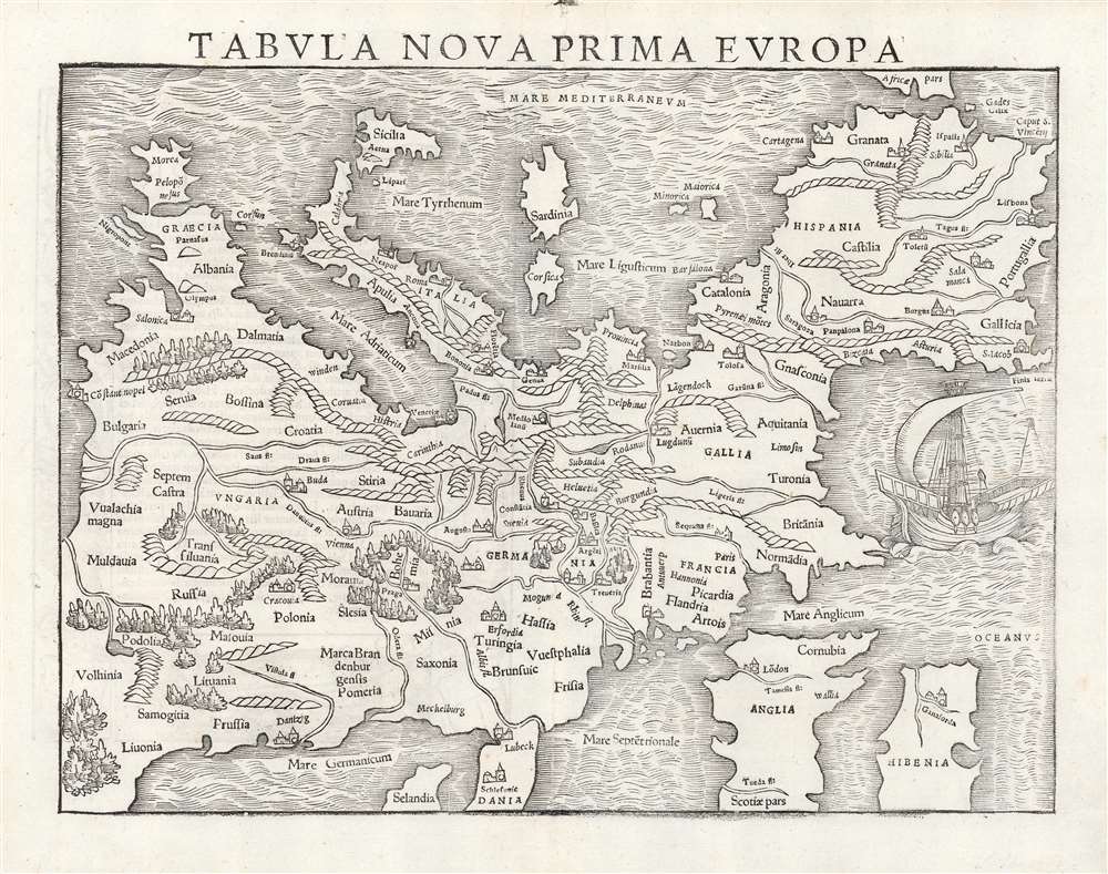
Tabula Nova Prima Europa.
sold
- Digital Map Information
- Suitable for large format printing
- Full resolution TIFF file
- ICC color profile embedded
- Delivered instantly via download link
This is a rare 1545 example of Sebastian Münster's southern-oriented map of Europe: an early imprint of the first acquirable map of Europe based on contemporary geographical information, and the only generally acquirable derivative of Martin Waldseemüller's unobtainable 1511 map of Europe. Münster's Geographia and Cosmographia provided for many years the literate European's only glimpses of the world, and these two works contained a number of maps with previously unseen contemporaneous knowledge of the areas they depicted. For Münster's readership, this map was almost certainly the first depiction of their home continent not based upon the 2nd century work of Claudius Ptolemy. (more details)
First geological map of Long Island.
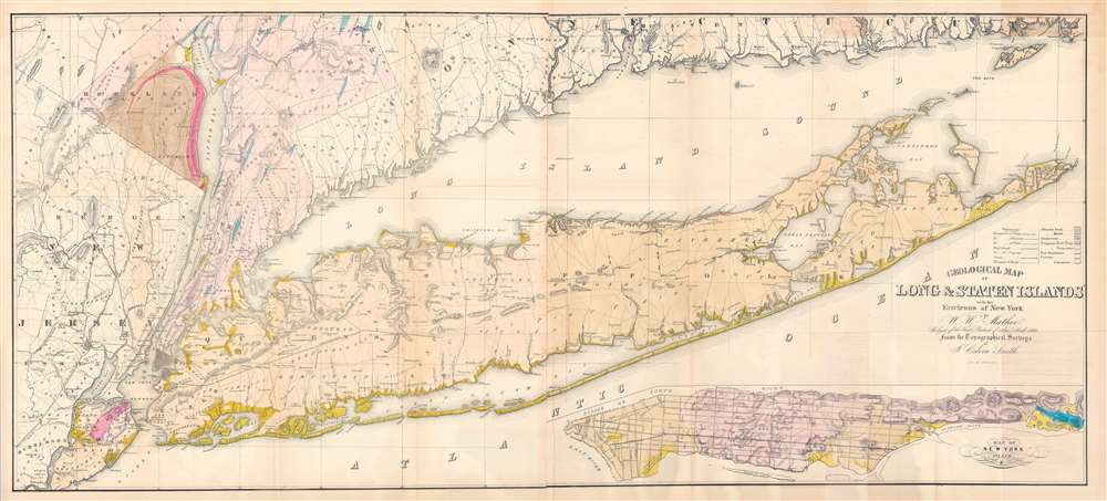
Geological Map of Long and Staten Islands with the Environs of New York.
sold
- Digital Map Information
- Suitable for large format printing
- Full resolution TIFF file
- ICC color profile embedded
- Delivered instantly via download link
A fine example of William W. Mather's 1842 large-scale geographical map of Long Island, New York - the first comprehensive geological study of the island. Issued prior to the completion of the Long Island Railroad and the subsequent Long Island land rush, this one of the largest, most detailed, and attractive maps of Long Island to appear in the 19th century. The map covers from New Jersey and Staten Island eastward as Montauk and Fisher's Island. Includes parts of Westchester, New Jersey, Rockland County, and the Connecticut coastline. A large inset map in the lower right depicts Manhattan with a special focus on geological features and topography. The line of the partially completed Long Island Railroad, which within 15 years would change the demographic of Long Island, is illustrated. Various important Long Island communities including the East Hampton, Bridgehampton, Southampton, Amagansett, Riverhead, and Sag Harbor, among others, are named. In many cases even individual buildings are detailed. The whole is laid out on a grid structure of ten-mile squares. (more details)
Stunning view of the Holy Land!

Bacon's Bird's-Eye View of the Holy Land.
sold
- Digital Map Information
- Suitable for large format printing
- File Size: 62.24 MB
- File Type: ZIP / TIFF
- ICC color profile embedded
- Delivered instantly via download link
A striking c. 1890 chromolithograph view of the Holy Land / Israel / Palestine by G. W. Bacon. Coverage extends from Mt. Lebanon and Mt. Hermon to the Dead Sea, Bethlehem, and Gath - thus covering the northern half of modern-day Israel and southern Lebanon. The Jordan River valley is particularly striking, with bold exaggerated depictions of both the Sea of Galilee and the northern part of the Dead Sea. Jerusalem is prominent at bottom center. (more details)
First Printed Modern Map of Asia.
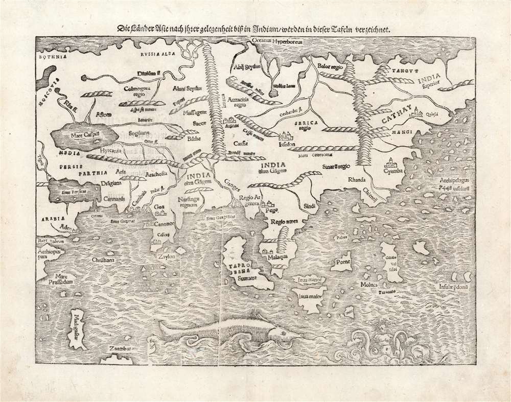
Die Lånder Asie nach ihrer gelegenheit bisz in Indiam werden in dieser Tafeln verzeichnet.
sold
- Digital Map Information
- Suitable for large format printing
- Full resolution TIFF file
- ICC color profile embedded
- Delivered instantly via download link
This is a 1578 strike of Sebastian Münster's 1540 map of Asia, the first printed map of that continent based on contemporary data, and the earliest obtainable map of the continent overall. The map depicts the Asian continent from the Caspian Sea and the Persian Gulf to the Pacific Ocean, and from the Arctic Ocean to the Indian Ocean. Although the interior detail is based heavily on Ptolemy, Münster also blends in information gleaned from recent discoveries made by Portuguese traders and adventurers, including Vasco da Gama (c. 1460 - 1624). Both the Portuguese outposts of Goa and Calicut, on the Indian subcontinent, are labeled, and the depiction of India is improved, moving closer to a truly accurate depiction, although still undersized. The inclusion of Sri Lanka (Zaylon) as an island is also an improvement; Münster applies Ptolemy's historical name for Sri Lanka - Taprobana - to Sumatra, which is placed correctly to the west of the Malay peninsula. (more details)
History as it was Happening - the Tet Offensive.
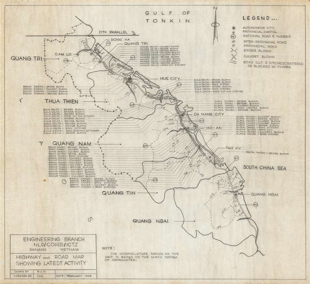
Highway and Road Map Showing Latest Activity.
sold
History as it was happening, this is a February 1968 manuscript map of northern Vietnam highlighting the damage done to Vietnam Highway 1 at the height of Tet Offensive. The map was drawn by P. J. V. of the Engineering Branch of CORDS, a civilian partnership with the U.S. military in Vietnam. By blowing bridges along the strategically critical highway, the North Vietnamese effectively disrupted American supply lines. Transportation along Highway 1 was not completely restored until March 1968. Sixty-five locations along the highway highlight blown bridges and culverts as well as 'cut and ditched' zones. Each section of highway is termed phonetically, ie. 'Alpha Tango', 'Yankee Delta', and 'Bravo Tango' 'based on the MACV system of coordinates'. Da Nang, Hue, Quang Ngai, and Dong Ha are labeled, along with several smaller towns and villages. (more details)
The Confederate retreat.
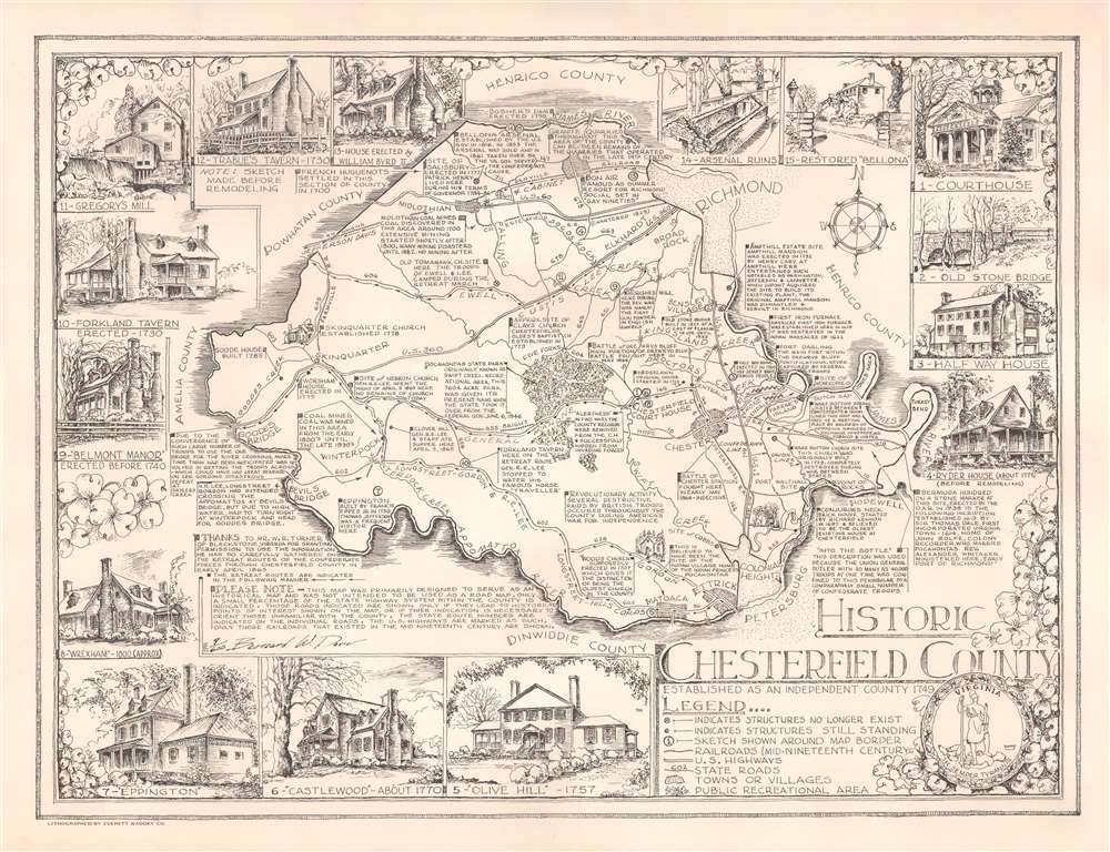
Historic Chesterfield County.
sold
This is a signed 1957 Bernard W. Davis pictorial map of Chesterfield County, Virginia. The map depicts the region between Richmond and Petersburg, Virginia, which witnessed the end of the American Civil War (1861 - 1865). Davis places great emphasis on the Civil War and refers to it as the 'War Between the States' at least once. Black arrows trace the retreat of Generals Longstreet, Gordon, and Robert E. Lee from Petersburg following their defeat by Grant. Other arrows illustrate the retreat of Generals Ewell, Custus, and Lee from Richmond, as well as the flight of Jefferson Davis and his cabinet. (more details)
The 1948 Armistice Line - problems ahead.

Jerusalem.
sold
This is a c. 1964 Tewfic Habesch pictorial city plan or map of Jerusalem. Buildings throughout the city are illustrated and labeled, including cinemas, hospitals, schools, and police stations. Other buildings, including the Bezalel Institute Museum, the Kind David Hotel, the Dome of the Rock, and Dormition Church, are labeled and illustrated with a small circular view. Color is used to differentiate between the Old City and newly constructed areas as well as between public buildings and those with historical or religious significance. (more details)
Mapping the pre-invasion bombardment of Iwo Jima.

Pre-Invasion Bombardment.
sold
- Digital Map Information
- Suitable for large format printing
- File Size: 11.52 MB
- File Type: ZIP / TIFF
- ICC color profile embedded
- Delivered instantly via download link
This is a 1945 map of Iwo Jima created for the pre-invasion bombardment by the U.S. Navy. Japanese airfields are illustrated and labeled, along with presumed positions of Japanese units. Mt. Suribachi, the site of the immortalized flag-raising captured in Joe Rosenthal's photograph, appears in the lower left corner and is identified. Seven invasion beaches (Green 1, Red 1, Red 2, Yellow 1, Yellow 2, Blue 1, Blue 2) are labeled on the island's southeast coast. Thick lines emanate from around the invasion beaches and likely illustrate projected advances from the beachheads by the invading Marines. (more details)
Walrus hunting, anyone? ... anyone?
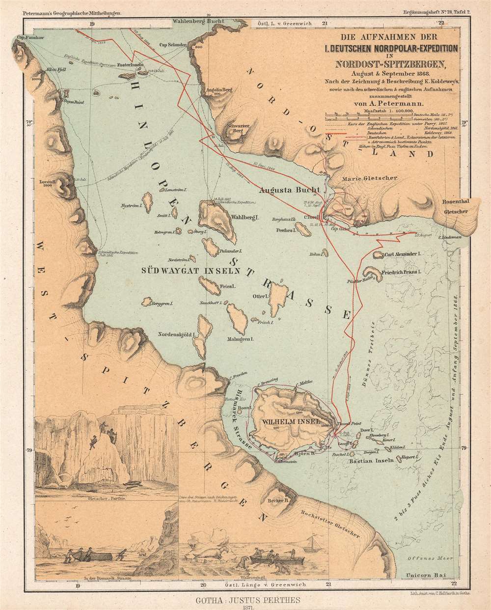
Die Aufnahmen der I. Deutschen Nordpolar-Expedition in Nordost-Spitzbergen, August und September 1868.
$350.00
Acquire
- Digital Map Information
- Suitable for large format printing
- File Size: 5.01 MB
- File Type: ZIP / TIFF
- ICC color profile embedded
- Delivered instantly via download link
This is an 1871 Augustus Petermann map of Hinlopen Strait in the Svalbard Archipelago. Hinlopen Strait separates Spitsbergen and Nordaustlandet. The map highlights the route of the First German North Polar Expedition through the strait, which is often impassable due ice. Dates, anchorages, and shore excursions are noted, along with a handful of depth soundings. The 1827 English expedition led by Sir William Edward Parry (1790 - 1855) and the 1861 Swedish expedition led by Nils Otto Gustaf Nordenskjöld (1869 - 1928) are also traced. Three views appear in the lower left corner illustrate shore excursions, among them a walrus hunt. (more details)
Months before the partition.
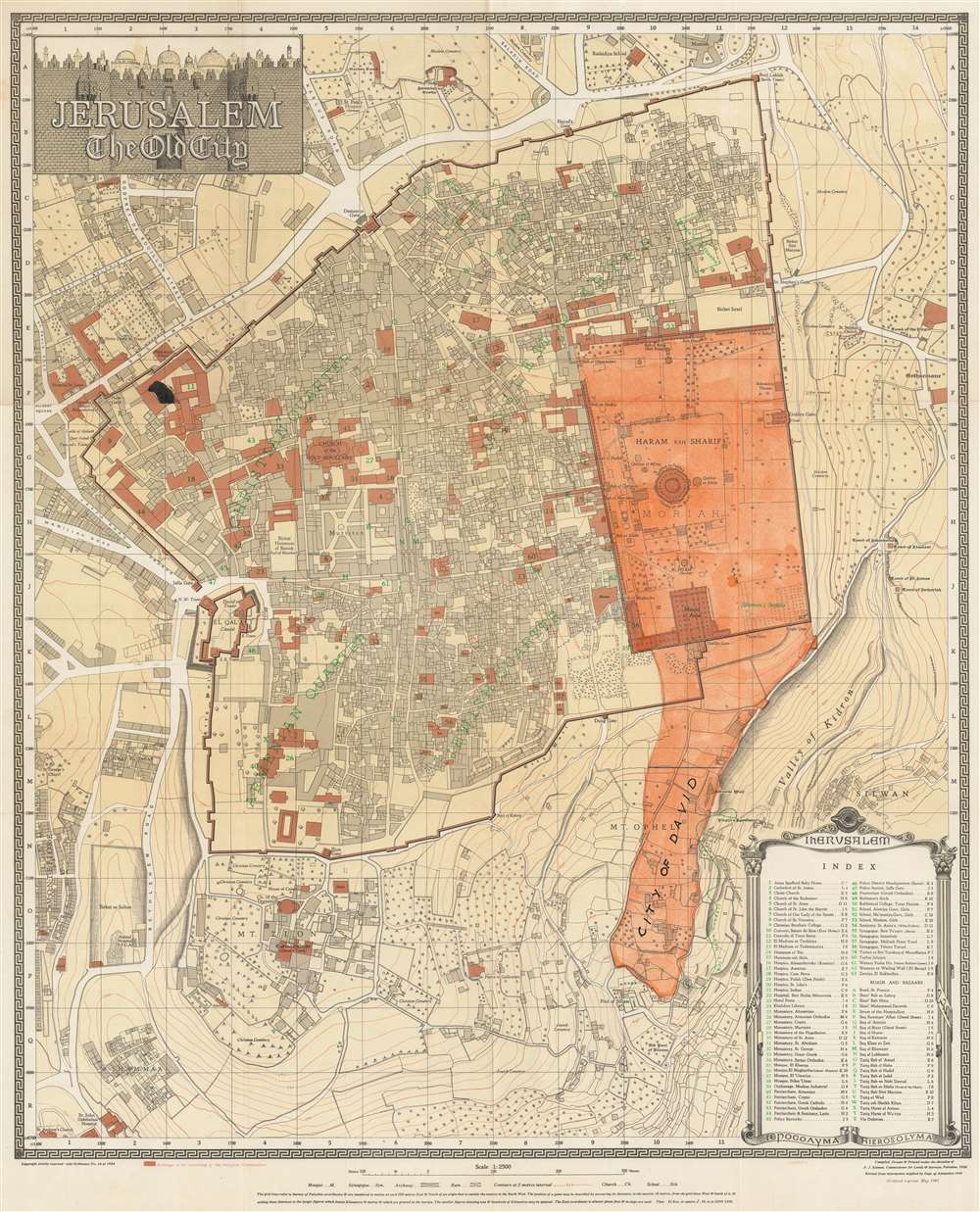
Jerusalem. The Old City.
sold
- Digital Map Information
- Suitable for large format printing
- File Size: 35.25 MB
- File Type: ZIP / TIFF
- ICC color profile embedded
- Delivered instantly via download link
This is Frederick John Salmon's 1947 city plan or map of Jerusalem's Old City, published six months before the United Nations adopted the Partition Plan for Palestine. Notable sites throughout the Old City are identified, with particular emphasis on Temple Mount. The Dome of the Rock, the El Aqsa Mosque, and Solomon's Stables (now the El-Marwani Mosque), are labeled, among other sites. Buildings owned by religious communities throughout the Old City and in the surrounding area are shaded brown. Sixty-three sites throughout the map are numerically labeled and correspond with an index situated in the lower right. Outside the Old City, King David's Tomb and the Church of the Dormition appear on Mt. Zion. Several hospitals, schools, and cemeteries are also identified. Orange manuscript shading highlights the City of David. Today, the City of David, a neighborhood in Silwan, is home to a Palestinian village that coexists with an Israeli settlement and an archaeological site believed to be the original settlement site. (more details)
The year the Florida Turnpike opened.

Florida Turnpike and the Avenues to Adventure in Florida's 12 Great Regions.
sold
This is a 1973 Florida Department of Transportation pictorial tourist road map of Florida, issued the year Florida's Turnpike was completed. Florida's twelve regions (as decided by the Department of Transportation) are shaded different colors with interstates are highlighted in red. The Florida Turnpike, which runs from Miami north to Interstate 75, appears is boldly green. Pictorial 'stamps' are scattered throughout and highlight famous buildings including the state capital and Disney World, NASA, and tourists enjoying the sun and surf. Fish, sailing ships, and a Miami Beach hotel also appear. A table of 'Florida's Attractions' separated out by region is situated in the lower left. (more details)
Penned by a Benjamin Franklin correspondent
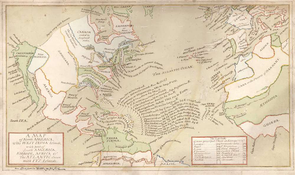
A Map of North America, and the West India Islands, with part of South America, Europe, Africa and The Atlantic Ocean with It's Islands von Benjamin Webb gezeichnet.
sold
- Digital Map Information
- Suitable for large format printing
- Full resolution TIFF file
- ICC color profile embedded
- Delivered instantly via download link
This is a beautifully executed c. 1763 manuscript map by Benjamin Webb, a German emigre working in London and a sometime correspondent with Benjamin Franklin. The map depicts the British Colonies in North America and the Atlantic, highlighting the European spheres of influence pursuant to the 1763 Treaty of Paris, which ended the Seven Years' War (1756 - 1763). It is uniformly meticulous and completed in a fine hand. It very likely was produced by Webb as part of his employment as a schoolmaster in London. Webb's map utilizes a geographical framework of mid-eighteenth century German cartography but includes numerous annotations bringing the map up to date with the 1763 Treaty of Paris. The combination of these elements are unique to this map, and fix its date with reasonable accuracy. (more details)
Iconic panorama of Manhattan.

New York from Bergen Hill Hoboken.
sold
- Digital Map Information
- Suitable for large format printing
- File Size: 81.56 MB
- File Type: ZIP / TIFF
- ICC color profile embedded
- Delivered instantly via download link
An enormous striking 1876 London Illustrated News bird's-eye view of Manhattan, New York City. The view looks east on Manhattan and Long Island from Bergen Hill, a high point in Hoboken, New Jersey, just across the Hudson River. Manhattan is covered from the Battery to roughly 96th Street. The Reservoir, today the Jacqueline Kennedy Onassis Reservoir, a large pond in Central Park, is evident at the extreme left. Hoboken is evident in the foreground, and in the distance Brooklyn, Williamsburg, and Long Island city are recognizable. Some of the larger buildings, generally church spires, are exaggerated in the vertical. Among these both Trinity Church and St. Paul's Chapel, in the financial district, stand out. The Hudson River, East River, and New York Harbor are busy with maritime traffic, including ferries, commercial ships, and sailing yachts. The view predates the construction of any major bridges across the Hudson or East Rivers. (more details)
Evokes the earliest history of Concord.
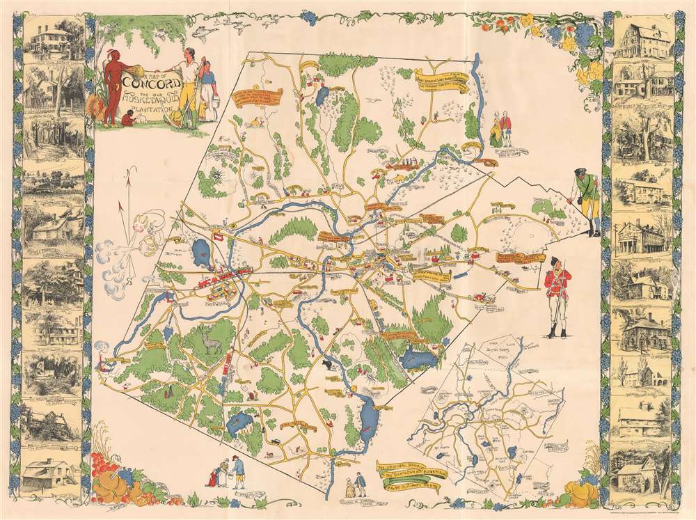
A Map of Concord. The Old Musketaquid Plantation.
sold
- Digital Map Information
- Suitable for large format printing
- Full resolution TIFF file
- ICC color profile embedded
- Delivered instantly via download link
This is a 1928 Helen Bodley pictorial map of Concord, Massachusetts. Depicting the town of Concord and its environs, Bodley provides an intriguing blend of the historical and the modern. Numerous American Revolutionary War references appear. One near Peter's Field states that it is the 'Birthplace of American Liberty April 19, 1775.' Other illustrations mark where the colonials ate breakfast the morning of the Battle of Lexington and Concord, and a trail of footprints marks the Colonial Army's path to intercept the British soldiers at Merriam's Corner while on their way back to Boston. A minuteman and a British redcoat look at each other along the right side. Sites around Concord are identified as well, including the library, armory, the Concord Country Club. Branches of the New York, New Haven, and Hartford Railroad run through the area. Vignette views of historic houses and other important buildings create the left and right borders, yet another way Bodley brings the historical into the modern mindset. (more details)