
A pictorial map chronicling American history.
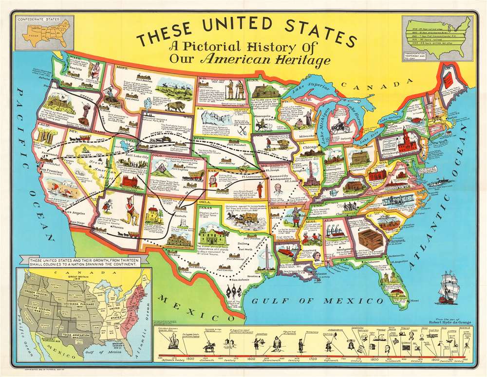
These United States A Pictorial History of Our American Heritage.
sold
- Digital Map Information
- Suitable for large format printing
- File Size: 59.16 MB
- File Type: ZIP / TIFF
- ICC color profile embedded
- Delivered instantly via download link
This is a 1949 Robert Hyde de Grange pictorial map of the United States. The map features illustrations of famous buildings, sites, historical events, and people, and presents an intriguing window into post-war America. Events chronicle American history from the 16th century, such as Ponce de Leon's discovery of Florida, through westward expansion and the Civil War to the early 20th century. Covered wagons, frontier forts, and gold miners complete the frontier aesthetic. The Mormon Trail, Oregon Trail, California Trail, and the legendary Pony Express all contribute too. Sites, including Mount Rushmore, Old Faithful, Fort Sumter, and Independence Hall, provide an even more comprehensive visual summary. A timeline along the bottom border identifies some critical events in the history of Europeans in North America, from Columbus's discovery in 1492 to the launching of the United Nations and the Atomic Age. An inset in the lower-left corner provides a more concrete summary of America's westward expansion, identifying the many purchases and expansions, along with the year each state joined the union. (more details)
Promoting the 'push-button' war of Tomorrow!

Map of the Army Air Forces Fair.
sold
- Digital Map Information
- Suitable for large format printing
- File Size: 11.31 MB
- File Type: ZIP / TIFF
- ICC color profile embedded
- Delivered instantly via download link
This is a 1945 United States Army Air Forces map of the Army Air Forces Fair at Wright Field in Dayton, Ohio, today's Wright-Patterson Air Force Base. Army officials called the fair 'the largest spectacle of its kind ever staged anywhere,' where many many previously classified aircrafts and other projects were presented. A flying display of a radio-controlled airplane used near the end of the war as target practice for anti-aircraft gunners and machine gunners on B-29s made headlines throughout the country. Seven Nazi rocket- and jet-propelled airplanes, one of which was captured shortly before the end of World War II, were publicly displayed for the first time.
Presented by the Air Technical Service Command, the fair was intended to argue for continued research and development funding to create the 'push-button' war of tomorrow. After visiting the fair, Lieutenant General James H. Doolittle, who led the famed Doolittle Raid over Tokyo in 1942, stated, 'The experimental and developmental research in aeronautics shown in this mighty exhibit tells more vividly than any other one thing why such must be continued through the years ahead. We have the necessary funds to see such program[s] through.' (more details)
Presented by the Air Technical Service Command, the fair was intended to argue for continued research and development funding to create the 'push-button' war of tomorrow. After visiting the fair, Lieutenant General James H. Doolittle, who led the famed Doolittle Raid over Tokyo in 1942, stated, 'The experimental and developmental research in aeronautics shown in this mighty exhibit tells more vividly than any other one thing why such must be continued through the years ahead. We have the necessary funds to see such program[s] through.' (more details)
Includes an inset of the 'congested district of Los Angeles'.
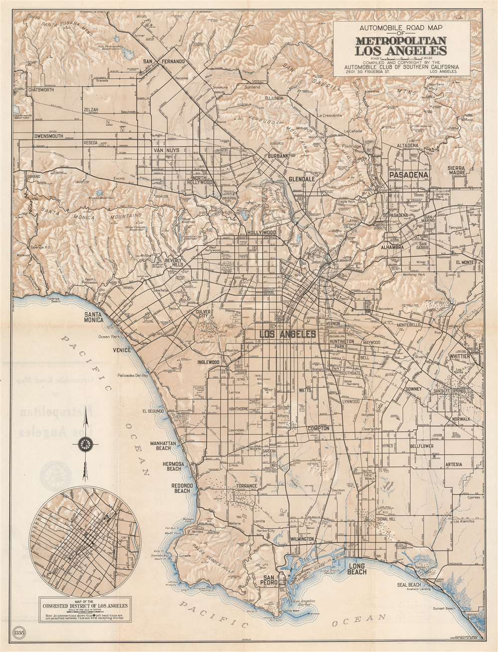
Automobile Road Map of Metropolitan Los Angeles.
sold
- Digital Map Information
- Suitable for large format printing
- File Size: 23.08 MB
- File Type: ZIP / TIFF
- ICC color profile embedded
- Delivered instantly via download link
This is a c. 1930 Automobile Club of Southern California city plan or map of Los Angeles, California. Depicting the region from the Santa Susana Mountains and San Fernando to San Pedro and Long Beach and from Oakwood Cemetery and Chatsworth Reservoir to Whittier and El Monte, Los Angeles, Pasadena, Glendale, Compton, Inglewood, Beverly Hills, Venice, Santa Monica, and Hollywood rank among the identified cities. Only major streets are illustrated and labeled. Small circles mark several oil fields, including the Redondo Oil Field and the Rosecrans Oil Field. Other than the oil fields, airports, cemeteries, a couple of high schools, and golf courses are highlighted. The Hollywood Bowl, in the Santa Monica Mountains above Hollywood, also appears. Peaks are identified in the San Gabriel Mountains, and the elevations for mountains are given in the Santa Monica Mountains and the Santa Susana Mountains. An inset in the lower-left corner detailed the 'congested district of Los Angeles' and even marks intersections where left-hand turns are not permitted between 7 a.m. and 6 p.m. except on Sundays. (more details)
Florida's celebrated Orange Blossom Trail!
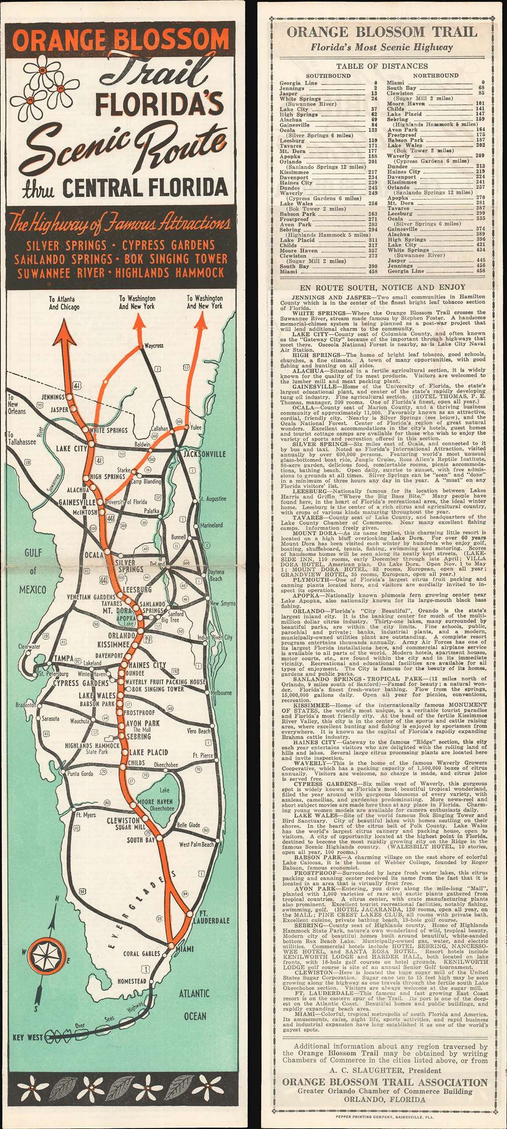
Orange Blossom Trail. Florida's Scenic Route thru Central Florida.
sold
- Digital Map Information
- Suitable for large format printing
- File Size: 8.11 MB
- File Type: ZIP / TIFF
- ICC color profile embedded
- Delivered instantly via download link
This is a c. 1950 Orange Blossom Trail Association highway map of Florida. The Orange Blossom Trail, highlighted in orange, traveled through central Florida and carried tourists from all over the country to visit places like the Bok Tower, Cypress Gardens, and Silver Springs. Many of these sites are detailed on the verso, with short paragraphs providing glimpses of what tourists could expect in each one. Apparently, the Orange Blossom Trail got its name from a famous train, the 'Orange Blossom Special', which inspired a song by the same name written by Ervin Rouse and Chubby Wise. It became one of the most popular bluegrass songs of the 20th century, and, in 1965, Johnny Cash recorded one of the finest versions. (more details)
Heretofore unknown wall map of New Jersey.
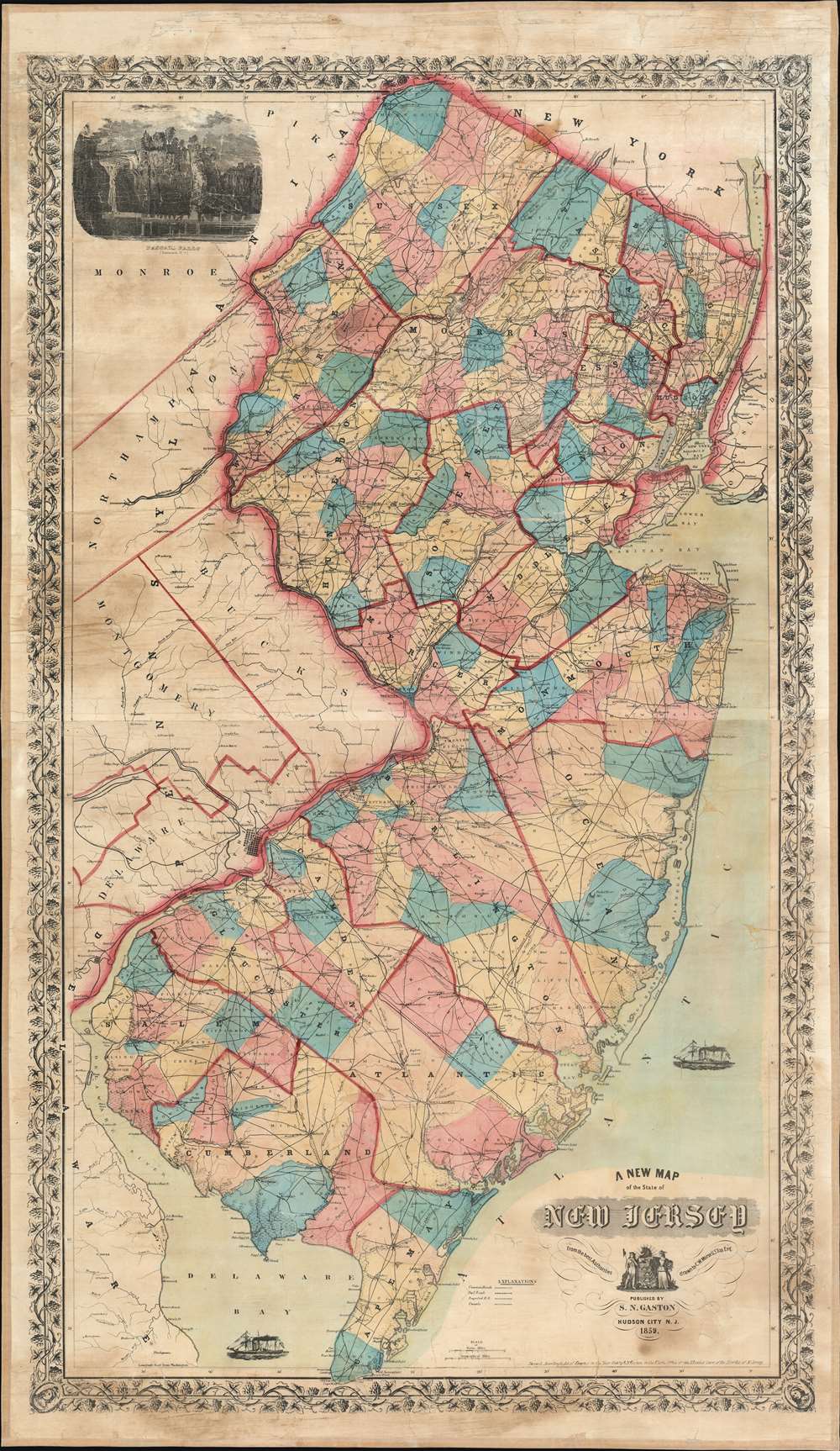
A New Map of the State of New Jersey.
sold
- Digital Map Information
- Suitable for large format printing
- File Size: 98.08 MB
- File Type: ZIP / TIFF
- ICC color profile embedded
- Delivered instantly via download link
A previously uncatalogued and impressively detailed 1859 Samuel N. Gaston wall map of New Jersey. Covering the entirety of New Jersey along with parts of New York, Pennsylvania, and Delaware, Gaston's map fills an essential gap in New Jersey cartography between the Squire map of 1836 and the Kitchell map of 1860. Black lines representing the state's growing road and railroad network stand in stark contrast against this patchwork of brilliant color. Railroads, a relatively new phenomenon, cross the state in every direction, with the Camden and Atlantic Railroad, New Jersey Railroad, and New Jersey Central Railroad among them. The proposed New York and Norfolk Railroad stands as it is illustrated by a surprisingly straight line through a large portion of eastern New Jersey. (more details)
The first state of the pre-East Coast Railroad map of Florida.
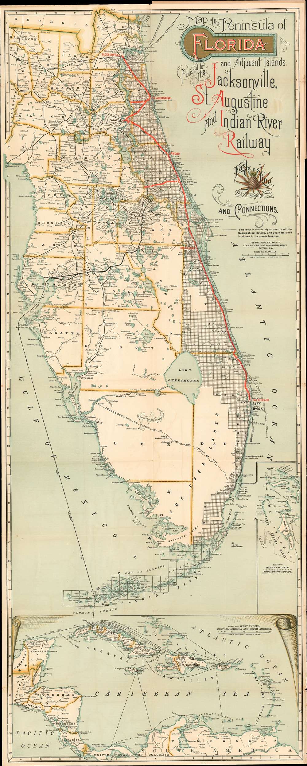
Map of the Peninsula of Florida and Adjacent Islands Published by the Jacksonville, St. Augustine and Indian River Railway.
sold
- Digital Map Information
- Suitable for large format printing
- Full resolution TIFF file
- ICC color profile embedded
- Delivered instantly via download link
A special rarity for the Florida collector, this is the first-state first-edition of the highly decorative 1894 map of peninsular Florida issued by the Mathews-Northrup Company for the Henry Morrison Flagler’s (1830 - 1913) Jacksonville, St. Augustine, and Indian River Railway, precursor to the Florida East Coast Railway. This is the first state of this famous map, pre-dating all other known examples and contemporaneous with, but in superior condition to, the Library of Congress example. The map covers from the Georgia Border to Key West and Cuba, and from Cedar Key to the Bahamas. The route of the railroad is illustrated in red overprinting extending from Jacksonville to Palm Beach, with major stops at Ormond, and Rockledge. Points further south, as far as Miami, can be reaching via the Lake Worth and Biscayne Bay Stage Line, which began operating around this time. The map also illustrates the 1892 J. E. Ingraham route across the Everglades – an exploratory expedition intended to determine the viability of a cross-Everglades railroad. (more details)
Attractive map on the dominant projection of the early 17th century.

Nova Totius Terrarum Orbis Geographica Ac Hydrographica Tabula...
sold
- Digital Map Information
- Suitable for large format printing
- DPI: 600
- File Size: 10.86 MB
- File Type: ZIP / TIFF
- ICC color profile embedded
- Delivered instantly via download link
This is a scarce 1646 map of the world on the Mercator Projection, produced for inclusion in the 1646 edition of Matthias Merian's Neuwe Archontologia cosmica. It is a meticulous and beautiful reduced version of Blaeu's similarly-titled 1606 map, which remained the dominant depiction of the world using that projection - appearing as it did in all of Blaeu's successful atlas editions up through the 1640s. While this map does not retain the decorative borders of its source, the cartographic detail is reproduced faithfully, including the polar projections shown in the lower corners of the map. (more details)
A scarce and elegant map showing the route to the Spice Islands and an early glimpse of Australia.
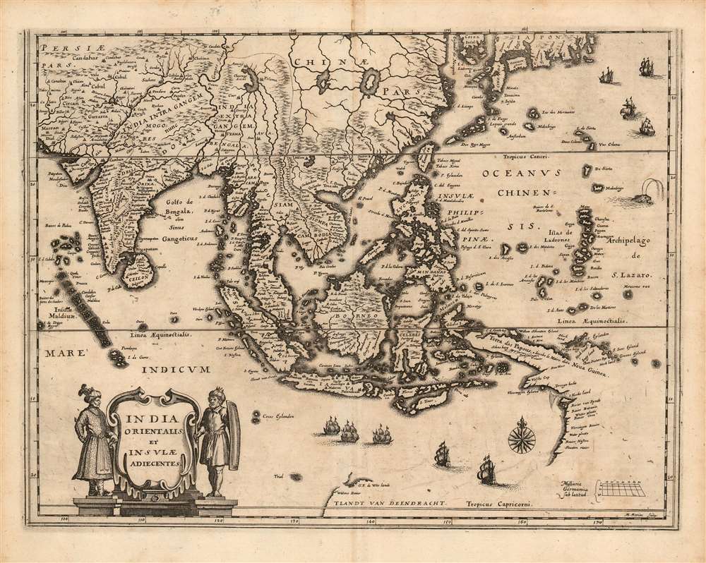
India Orientalis et Insulae Adiecentes.
sold
- Digital Map Information
- Suitable for large format printing
- DPI: 600
- File Size: 11.33 MB
- File Type: ZIP / TIFF
- ICC color profile embedded
- Delivered instantly via download link
This is a scarce 1638 Matthais Merian map of India, Southeast Asia, China, and Japan, including some of the earliest mapped portions of Australia. The map is beautifully engraved, decorated with nine sailing ships, a sea monster, and an elegant compass rose; the title cartouche is flanked by soldiers in Mogul garb. The mapping of India appears to be largely consistent with that of Linschoten. The Philippines are shown in sharp detail, albeit exaggerated in size. New Guinea is shown according to Le Maire's charting. (more details)
Traces the voyages of discovery of Cook, Vancouver and others - A first edition!
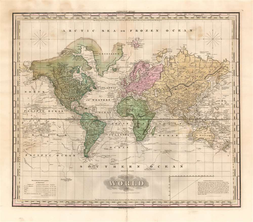
The World on Mercator's Projection.
sold
- Digital Map Information
- Suitable for large format printing
- DPI: 600
- File Size: 17.71 MB
- File Type: ZIP / TIFF
- ICC color profile embedded
- Delivered instantly via download link
This is an 1823 first edition Henry Shenk Tanner map of the world on Mercator's projection. The map depicts six of the seven continents, excluding Antarctica, stopping at the Antarctic Circle. Curiously, the only continent not illustrated in its entirety is North America. Its northern coastline simply blends into the 'Arctic Sea or Frozen Ocean'. The northern coastline of Greenland is also missing, highlighting that Arctic exploration remained in its infancy. The northern coast of Russia is nonetheless depicted fully. Cities throughout the world appear, including New York, Boston, Washington D.C., Havana (Havanna), Veracruz, London, Paris, and Madrid. The routes taken by 18th century explorers wind their way across the world's oceans and trace the voyages of many, including those of Captains Cook, Vancouver, and Perouse. (more details)
The Bombing of Hiroshima.

NEWSMAP For the Armed Forces. V-E Day + 15 Weeks - 192nd Week of U.S. Participation in the War.
sold
- Digital Map Information
- Suitable for large format printing
- Full resolution TIFF file
- ICC color profile embedded
- Delivered instantly via download link
This is the chilling Atomic Bomb issue from the iconic World War II Newsmap series. Issued in 1945 as the 'Army Information Branch Newsmap of eastern China and Japan' shortly after the bombing of Hiroshima and Nagasaki, one week before the Japanese announced their surrender to the Allies to end the Pacific War, World War II. (more details)
A first edition!
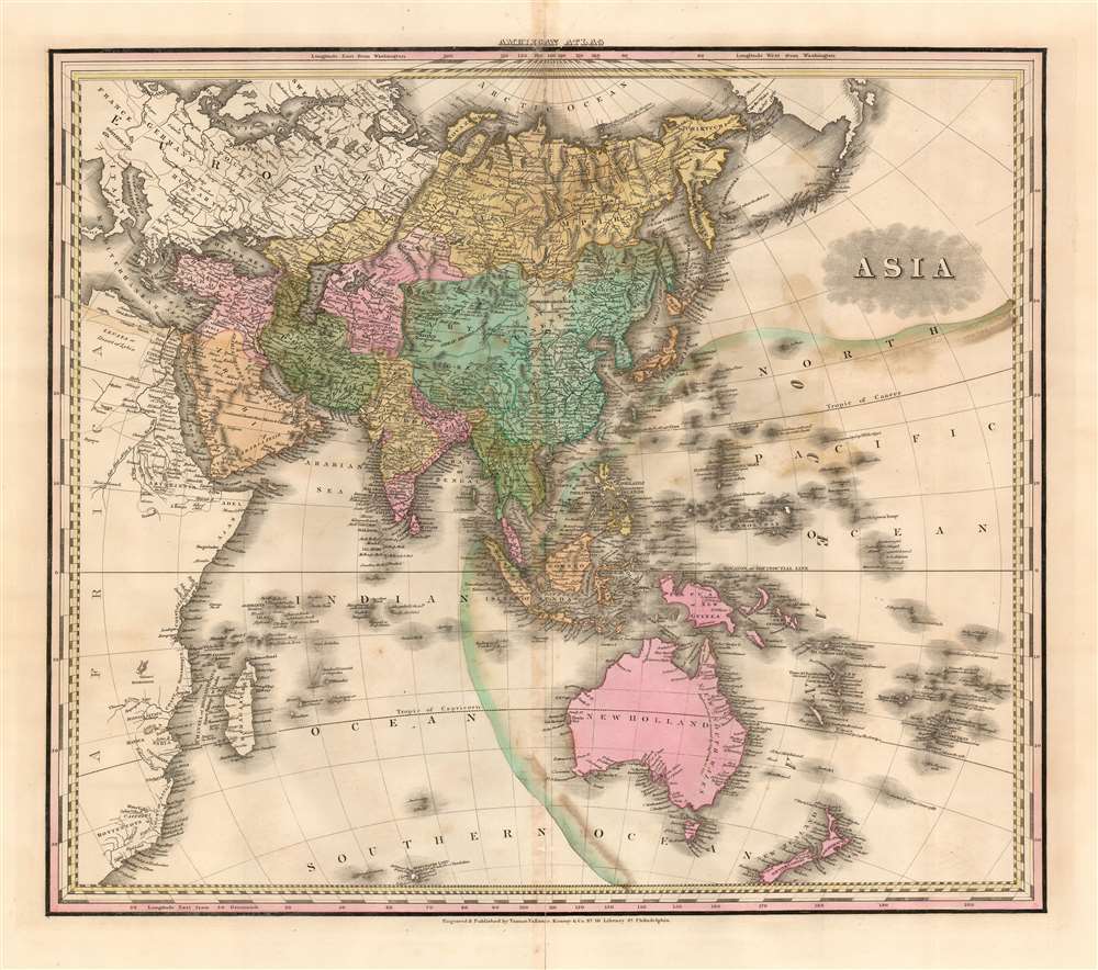
Asia.
$750.00
Acquire
- Digital Map Information
- Suitable for large format printing
- DPI: 600
- File Size: 21.58 MB
- File Type: ZIP / TIFF
- ICC color profile embedded
- Delivered instantly via download link
This is an 1823 first edition Henry Shenk Tanner map of Asia. The map depicts from continental Europe and Africa (though both are uncolored) to Alaska and from the Arctic Ocean to Australia, South Africa, and the Southern Ocean. A few cartographic oddities create intriguing questions. One such abnormality is Hokkaido not being included in the Islands of Japan. Another concerns Luzon, in the Philippines, which is bisected in such a way that it resembles two peninsulas - probably in an attempt to represent the Cagayan River. Myriad locations throughout the region are identified, including Singapore, Persia, Tibet (Thibet), and Nepal (Napaul). The coasts, which had been known to European traders and explorers for hundreds of years, exhibit the most detail, while some inland regions, such as the Gobi Desert, New Guinea, and most of Australia, bear very little detail. (more details)
The first railway built on the north side of the St. Lawrence River.
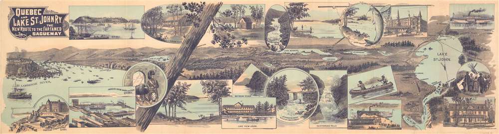
Quebec and Lake St. John Railway. The New Route to the Far Famed Saguenay.
sold
- Digital Map Information
- Suitable for large format printing
- Full resolution TIFF file
- ICC color profile embedded
- Delivered instantly via download link
This is an 1898 Toronto Lithographing Company View and Map of the Quebec and Lake St. John Railway in Canada. Running from Quebec City to Roberval on Lake St. John, the 'Quebec and Lake St. John Railway' was the first railway constructed on the north side of the St. Lawrence River. A pictorial tourist view occupies the front of this fold-out, illustrating Quebec on the left and Lake St. John on the right. Towns, clubs, game clubs, and lakes dot the landscape between the railroad's two termini. Enticing views, meant to encourage tourism line the top and bottom and detail the Chateau Frontenac in Quebec, club houses and fisherman's huts, picturesque waterfalls and luxurious hotels. On the verso, aside from the practical information which includes time tables and extensions, is a clever railway map in the form of a fish, meant to further reinforce the region's wealth of outdoor activity. (more details)
Scarce mapping of Oakland. Outlines the Fire District in San Francisco.

Map of Oakland Alameda and Berkeley. / Map of the City and County of San Francisco.
sold
- Digital Map Information
- Suitable for large format printing
- Full resolution TIFF file
- ICC color profile embedded
- Delivered instantly via download link
This is a 1906 Hermon Candrian city maps or plans of Oakland / Berkeley and San Francisco, California, published shortly after the disasterous 1906 San Francisco Earthquake. Depicting Berkeley, Oakland, and Alameda on one side and San Francisco on the other, green lines trace streetcar routes in all four cities. Green also highlights the University of California Berkeley, the Deaf, Dumb, and Blind Asylum, and the St. Mary's, Jewish, and Mountain View Cemeteries. The Key Route, the Southern Pacific mainline, and the Coast Line narrow gauge all cross San Francisco Bay west toward San Francisco. An advertisement for Theodore Gier Wine Company of Oakland appears in the lower-left corner. At the same time, an ad for William Knapp and Company, an importer and manufacturer's agent, occupies the upper right. In San Francisco, the Presidio Reservation, Golden Gate Park, the Alms House, and numerous parks, squares, and cemeteries are also shaded green. An advertisement for the Sutter Home Wine and Distilling Company, which still exists today, is situated in the upper right corner. (more details)
A first edition!

Africa.
sold
- Digital Map Information
- Suitable for large format printing
- DPI: 600
- File Size: 29.06 MB
- File Type: ZIP / TIFF
- ICC color profile embedded
- Delivered instantly via download link
This is an 1823 first edition Henry Schenck Tanner map of Africa. Depicting the entire continent, Tanner's map visually represents the extent of Western knowledge of the dark continent - called so because of the general lack of knowledge about it in European mapmaking circles. The regions along the coast exhibit a high level of detail, with different nations and regions illustrated in different colors. The Nile and Niger river systems, both of which had been extensively explored and mapped, are depicted in detail. Other important aspects of African geography are depicted, including Lake Malawi (L. Maravi), Zanzibar, and Pemba Island. At this point in history Zanzibar was very wealthy and a valuable property under the Sultanate of Oman as it was the main slave market for the Swahili Coast during the 1830s. The interior of the continent, however, displays much less detail. Cities along the Niger, such as Timbuktu, are identified, but the Sahara (Zaara) is rather blank, and the interior of sub-Saharan Africa is labeled simply as 'unknown parts'. (more details)
Bilingual English/Chinese plan of Kowloon.

Kowloon Street Plan.
sold
This is a 1978 Caltex bilingual English and Chinese city plan or map of Kowloon, Hong Kong. Depicting the city in a series of seven 'insets', the largest inset focuses on Kowloon from the Lionrock Tunnel Road to Salisbury Road and the Star Ferry Pier and from the Sham Shui Po Ferry Pier to San Po Kong and the Hong Kong (Kai Tak) Airport. Both English and Chinese identify nearly all Kowloon's roads, along with many of its parks, schools, hotels, and hospitals. The other six smaller insets focus on parts of the city that otherwise would not have fit on the sheet and display the same level of detail that is present in the central map. A legend, situated in the lower left corner, explains the various symbols employed by the cartographer and notes that churches, temples, markets, and bus routes are all present. (more details)
A spectacular bird's eye view of Manhattan.

Supervue of New York.
sold
- Digital Map Information
- Suitable for large format printing
- File Size: 34.02 MB
- File Type: ZIP / TIFF
- ICC color profile embedded
- Delivered instantly via download link
This is a spectacular 1937 Samuel Freedman bird's eye view Supervue map of New York City. Depicting the entirety of Manhattan from the Harlem River to Battery Park, the map illustrates and identifies myriad world-famous sites. Among these are the Empire State Building, the Chrysler Building, Grand Central Station, and the Metropolitan Museum of Art. Neighborhoods and districts throughout the borough are referenced as well, including Greenwich Village, Little Italy, Chelsea, the Theatre District, and the Financial District. White lines highlight the city's iconic street grid and block letters label most of the streets and avenues. Broadway, Fifth Avenue, and Park Avenue shine brighter than the rest. The Brooklyn Bridge, Manhattan Bridge, and Williamsburg Bridge are all drawn in profile. A note in Queens promotes the World's Fair, which would open in 1939. (more details)
A comical pictorial tourist map of London.

The New Pictorial Map of London.
sold
- Digital Map Information
- Suitable for large format printing
- File Size: 18.63 MB
- File Type: ZIP / TIFF
- ICC color profile embedded
- Delivered instantly via download link
This is a c. 1930 Geographia pictorial city map of London, England. A comical piece, London is depicted from Hyde Park to St. Paul's Cathedral and from Regents Park to St. George's Circus and Elephant and Castle. The creator's creativity is evident, particularly at the bottom left where Elephant and Castle is illustrated as an elephant with a castle on its back. The law courts are noted by a caricature of a jurist, and the zoo in Regent's Park houses a very large, but cheerful, monster. Savile row, the famous street renowned for its bespoke tailoring, is marked by a very tall man being measured for a suit. The client is so tall that the tailor is illustrated standing on a ladder to get the needed measurements. Nelson's Column in Trafalgar Square sits at the center of a merry-go-round of cars. Other locations around the city, such as St. Paul's, the Houses of Parliament, Westminster Abbey, Buckingham Palace, the British Museum, the National Gallery, and the Victoria and Albert Museum, are illustrated in a more conventional monumental manner. London's train stations, Euston, St. Pancras, King's Cross, Charing Cross, and Victoria, are illustrated and labeled as well. The parts of the United Kingdom served by each station are also noted. Tube stations are marked by red signs akin to those used to mark Underground stations throughout London. (more details)
Colorful stationery promoting Omaha, Nebraska, with a typewritten letter to Smith and Wesson on the verso.

Omaha Geographical Center of the U.S.A.
sold
- Digital Map Information
- Suitable for large format printing
- Full resolution TIFF file
- ICC color profile embedded
- Delivered instantly via download link
This is a 1928 Epsten Lithography Company stationery map of Nebraska promoting Omaha as a great city in which to do business. The map depicts the region from Idaho to the Mississippi River and from North Dakota to Kansas and Colorado. Omaha is marked by a large black target with railroad lines snaking out in every direction, emphasizing how connected Omaha is to the rest of the country. Laudatory promotional text is situated below the map beneath the title ' A Natural Metropolis'. A wonderful view of downtown Omaha occupies the bottom of the sheet. (more details)
The rarest of the Texas 'Treaty Map' series.
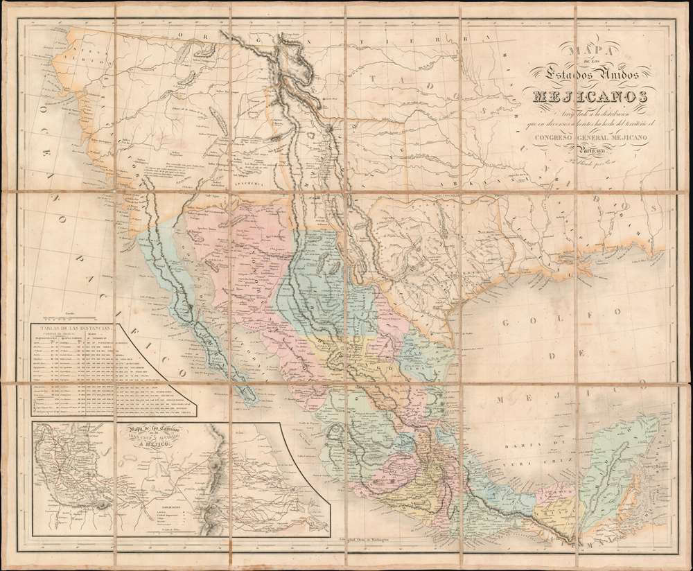
Mapa De Los Estados Unidos Mejicanos Arreglado a la distribucion que en diversos decretos ha hecho del territorio el Congreso General Mejicano.
sold
- Digital Map Information
- Suitable for large format printing
- Full resolution TIFF file
- ICC color profile embedded
- Delivered instantly via download link
The extremely rare 1851 edition of the Jean-Frédéric Rosa Map of Texas, California, and Mexico - considered the rarest of the 'Treaty Maps' used to settle the Mexico-Texas border between 1847 and 1853. This is grand map covering all of Mexico and much the southwestern part of the United States from the Pacific to the Apalachicola River and extending as far north as Great Salt Lake (Timpanogos). It was published in Paris by Jean-Frédéric Rosa on behalf of the Mexican Congreso General in anticipation of renewed negotiations over that part of the southwest that would eventually be annexed to the United States as part of the Gadsden Purchase. The map, generally based upon the 1826 Tanner map of Mexico, offers much of interest, including a recognition of American claims in Texas and Upper California, and multiple border configurations within Texas itself. It is the rarest of the three maps, along with the Tanner and Disturnell, used to negotiate the Gadsden Purchase. (more details)
Greenwich Village during Prohibition!

50% Chart of Greenwich Village for Navigators Who Will Travel on Water or Otherwise. Once the Ninth Ward and Ancient Home of the Celt, Now Simply Hobohemia or 'The Coney Island of the Soul.'
sold
- Digital Map Information
- Suitable for large format printing
- Full resolution TIFF file
- ICC color profile embedded
- Delivered instantly via download link
A wonderfully amusing February 1933 Prohibition Era (1920 - 1933) pictorial speakeasy and nightclub map of Greenwich Village, Manhattan, New York City by the legendary New Yorker / Judge cartoonist Frank Hanley. (more details)