
A board game created to promote the Little Orphan Annie radio show.

Little Orphan Annie's Treasure Hunt.
sold
- Digital Map Information
- Suitable for large format printing
- File Size: 2.51 MB
- File Type: ZIP / TIFF
- ICC color profile embedded
- Delivered instantly via download link
This is a 1933 Wander Company fantasy map board game of a treasure hunt featuring the radio show character Little Orphan Annie. The map traces the 'charted course' from the Start through several childhood obstacles faced by children that misbehave before reaching ... (more details)
Traces many of the expeditions mounted in search of the arctic explorer Captain Sir John Franklin and his crew.
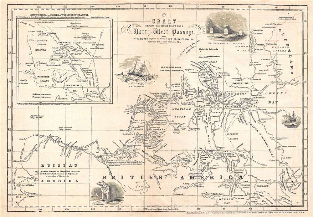
Chart Showing the Recent Search for a North-West Passage. Also the Coast Explored in Search of Sir John Franklin, Between the Years 1848 and 1854.
sold
- Digital Map Information
- Suitable for large format printing
- DPI: 300
- File Size: 3.48 MB
- File Type: ZIP / TIFF
- ICC color profile embedded
- Delivered instantly via download link
This is an 1854 John Disturnell map of northern North America tracing the explorations in the North American Arctic in search of Sir John Franklin, an Arctic explorer that went missing in 1847. The map depicts the region from Alaska (Russian America) to Greenland and from Ellesmere Island to Hudson Bay. Incredibly detailed, myriad locations throughout the region are identified. The courses of several different expeditions are traced, including the H.M.S. Investigator and the H.M.S. Phoenix, along with the expeditions led by Lieutenant De Haven and Captains McClure and Collinson. The location where the Resolute and the Intrepid were abandoned in May 1854 is also noted. An inset map in the upper left corner illustrates the routes taken by Lieutenant De Haven in 1850 and Captain Penny and his crew in 1851 in and north of Wellington Channel. Several vignettes also populate the map, including a polar bear, ice hummocks, and the three graves discovered at Beechey Island. (more details)
The final battle between Colonel Sterling Price's force and the insurgents leadint the Taos Revolt.
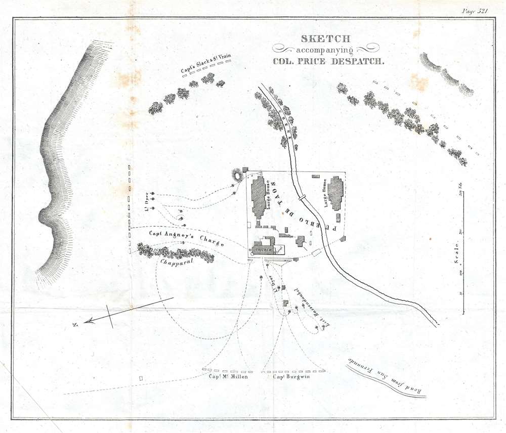
Sketch accompanying Col. Price Despatch.
sold
- Digital Map Information
- Suitable for large format printing
- DPI: 300
- File Size: 1.18 MB
- File Type: ZIP / TIFF
- ICC color profile embedded
- Delivered instantly via download link
This is an 1847 William Hemsley Emory map of the Siege of the Pueblo de Taos, a modern-day National Historic Landmark and UNESCO World Heritage site located one mile north of the modern city of Taos, New Mexico. Centered on the pueblo with the Red Willow Creek running through it, the map illustrates the deployment of Colonel Sterling Price's men as he laid siege to the Pueblo de Taos, the final stronghold of the insurrectionists that started the Taos Revolt only a few weeks prior to the siege with the murder of Territorial Governor Charles Bent. (more details)
The first battle in the Taos Revolt of 1847 between U.S. forces and Hispano and Puebloan insurgents.
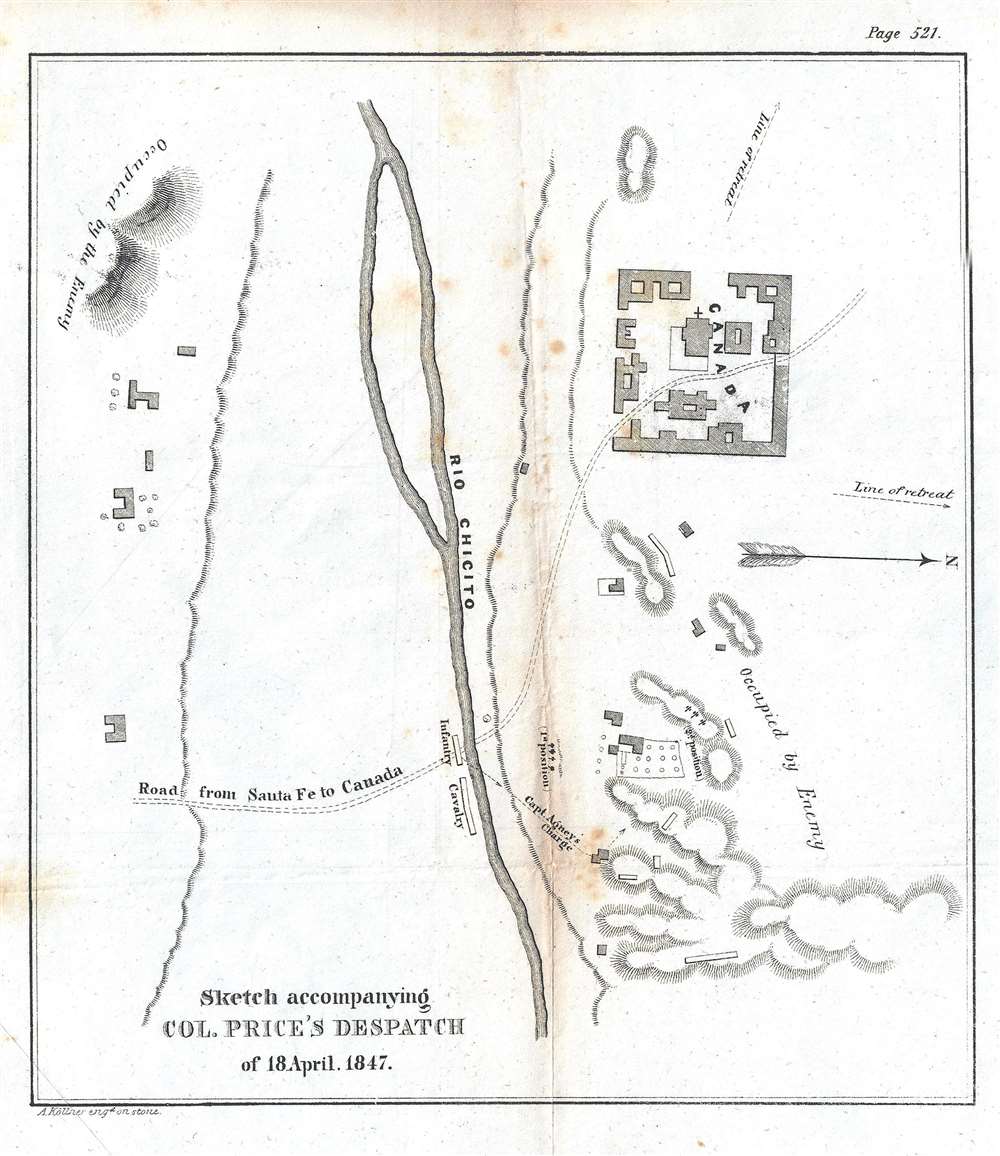
Sketch accompanying Col. Price's Despatch of 18 April 1847.
sold
- Digital Map Information
- Suitable for large format printing
- DPI: 300
- File Size: 1.08 MB
- File Type: ZIP / TIFF
- ICC color profile embedded
- Delivered instantly via download link
This is an 1847 William Hemsley Emory map of the Battle of Cañada one of the battles during the Taos Revolt in and near Taos, New Mexico, which was part of the Mexican-American War. Oriented to the west, the map is bisected by the Rio Chicito, with the road from Santa Fe to Cañada illustrated by two dashed lines. Cañada itself is on the north side of the river and several buildings are noted, though none are labeled. Numerous buildings are illustrated throughout the countryside, along with the region's topography, allowing the viewer to have some understanding of the terrain where the battle occurred. (more details)
Also known as the Battle of the Plains of Abraham, this battle was a key British victory in the French and Indian War.
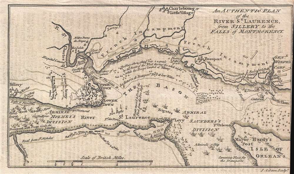
An Authentic Plan of the River St. Laurence, from Sillery to the Falls of Montmorency.
sold
- Digital Map Information
- Suitable for large format printing
- DPI: 300
- File Size: 1.1 MB
- File Type: ZIP / TIFF
- ICC color profile embedded
- Delivered instantly via download link
This is a 1759 John Gibson map of the Battle of Quebec during the French and Indian War, the name for the North American theater during the 7 Years' War between Britain and France. Also known as the Battle of the Plains of Abraham, the map depicts the region from the sillery to Montmorency Falls and from Charlebourg to the Isle of Orleans (Isle d'Orléans). The blockading British fleet is illustrated in the St. Lawrence, while French encampments are labeled all along the river from Quebec City to the Montmorency Falls. The battle, which took place to the west of Quebec City, is illustrated by French and British battle lines. (more details)
A lovely map of the Isle d'Orleans / Isle of Orleans and the vicinity of Quebec City, Canada.
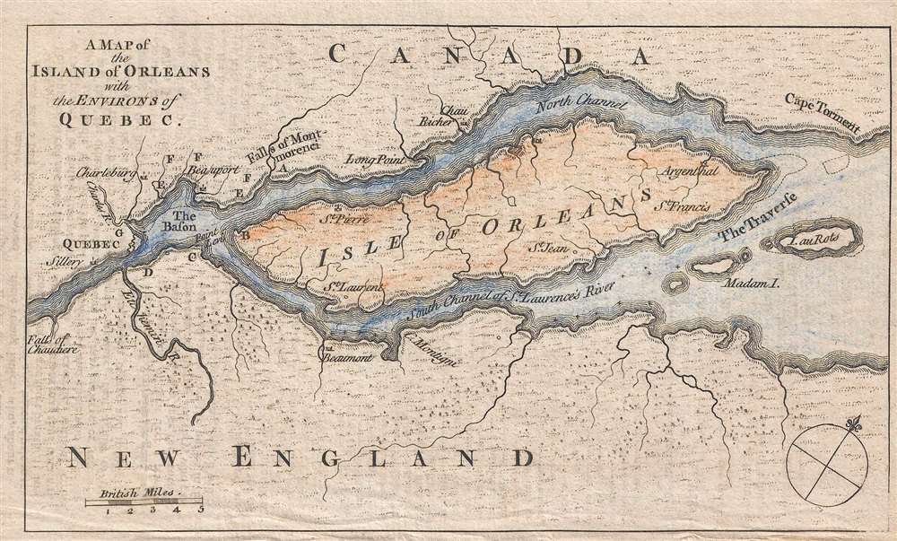
A Map of the Island of Orleans with the Environs of Quebec.
sold
- Digital Map Information
- Suitable for large format printing
- DPI: 300
- File Size: 1.14 MB
- File Type: ZIP / TIFF
- ICC color profile embedded
- Delivered instantly via download link
This is a 1759 map of the Isle of Orleans (Isle d'Orléans) and the environs of Quebec City, Quebec, Canada. The map depicts the region from the Falls of Chaudiere (Chutes de la Chaudière) to Cape Torment and from the territory north of the North Channel of the ... (more details)
A charming and slightly comical pictorial map of San Francisco created near the end of World War II.

[San Francisco.]
sold
- Digital Map Information
- Suitable for large format printing
- File Size: 2.44 MB
- File Type: ZIP / TIFF
- ICC color profile embedded
- Delivered instantly via download link
This is a 1945 Gus Schneider pictorial map of San Francisco, California. The map depicts the city from Fleishhacker Park across the Golden Gate Bridge to Sausalito and from the Pacific Ocean to San Francisco Bay. Wonderfully illustrated, life in mid-1945 San ... (more details)
An attractive map of the Leeward Islands.

The Dutch Islands of St. Eustatia, Saba, and St. Martins; The French Island of St. Bartholomew; The English Islands of St. Christophers, Nevis, and Anguilla; with the smaller Islands and Keys adjoining.
sold
- Digital Map Information
- Suitable for large format printing
- DPI: 300
- File Size: 1.74 MB
- File Type: ZIP / TIFF
- ICC color profile embedded
- Delivered instantly via download link
This is a scarce 1781 John Lodge map of the Leeward Islands or the northern islands of the Lesser Antilles chain in West Indies. It covers from Hat Island (Sombrero) south as far as Nevis and depicts the colonial possessions of the Dutch, French and the ... (more details)
Map of the United States just prior to the Mexican American War. Shows the Republic of Texas.
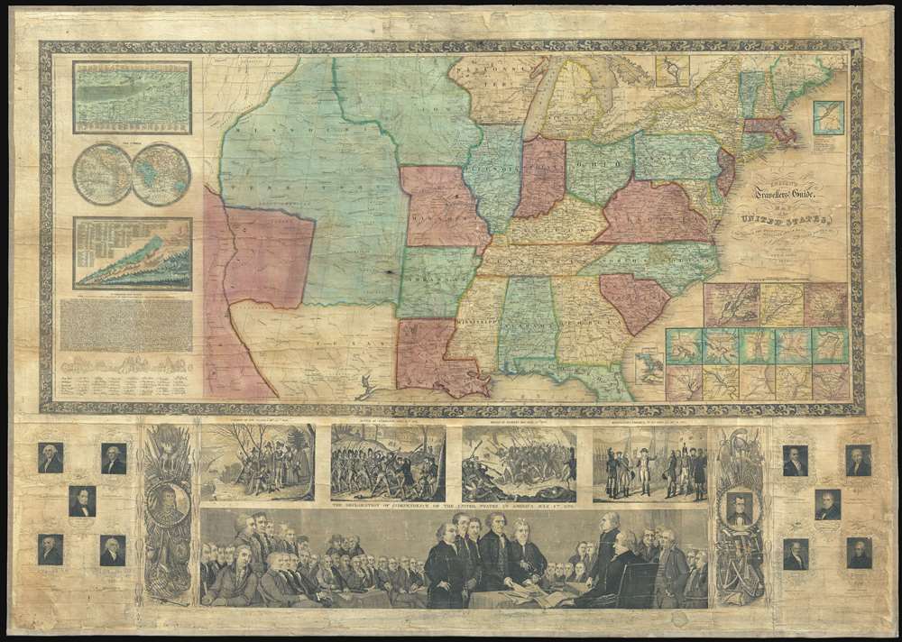
Ensign's Travellers' Guide, and Map of the United States, containing the Roads, Distances, Steam Boat and Canal Routes and c.
sold
- Digital Map Information
- Suitable for large format printing
- DPI: 300
- File Size: 54.44 MB
- File Type: ZIP / TIFF
- ICC color profile embedded
- Delivered instantly via download link
An extremely scarce variant on Ensign and Thayer's series of highly decorative United States wall maps. This map, dated 1845, predates the annexation of Texas and the Mexican-American War by one year. It illustrates the Republic of Texas according to its early proclaimed borders, names Austin's colony, and identifies Austin as the capital. In addition, the map features a large Missouri Territory. Small mountains and rivers charts on the Bulla / Darton model appear in the upper left quadrant. The bottom of the map features a large panorama of the Signing of the Declaration of Independence as well as various scenes from American History. To either side are illustration of Metacom, the Pokunoket Sachem called 'King Philip' and James Polk, who had just been elected 11th president of the United Sates. Portraits of other former presidents fan out on either side of the panorama. (more details)
Illustrates the 1864 Battle of Nashville, one of the largest Union victories of the American Civil War.

Battlefields in front of Nashville where the United States Forces commanded by Major General Geo. H. Thomas defeated and routed the Rebel Army under General Hood December 15th and 16th 1864.
sold
- Digital Map Information
- Suitable for large format printing
- File Size: 6.2 MB
- File Type: ZIP / TIFF
- ICC color profile embedded
- Delivered instantly via download link
This is a separately issued 1866 Peseux map of the battles surrounding Nashville, Tennessee which took place on December 15th and 16th 1864. Oriented towards the east, the map depicts the region from the Cumberland River to south of Overton Hills and from Confederate strongpoints east of the city to the Charlotte Pike west of Nashville. Highly detailed, the regions topography is meticulously engraved, with elevations of nearly every high point noted. Most of these were locations for Union strongpoints and forts along the defensive lines constructed south of Nashville. Numerous streets are illustrated heading into / leaving from Nashville, including the Franklin Pike and the Granny White Pike, both of which were used by the defeated Confederate army in their retreat back toward Franklin. The battle is traced in astonishing detail, with each unit represented and colored with a different color scheme to make them easier to identify. Movements from both days of the battle are highlighted, although almost exclusively from the Union perspective. (more details)
Part of General Grant's Overland Campaign, the Battle of Totopotomoy Creek immediately preceeded the Battle of Cold Harbor.

Totopotomoy.
sold
- Digital Map Information
- Suitable for large format printing
- File Size: 27.36 MB
- File Type: ZIP / TIFF
- ICC color profile embedded
- Delivered instantly via download link
This is an 1867 John Weyss and Nathaniel Michler map of the battlefield of Totopotomoy Creek, Virginia. The map depicts the region from the Virginia Central Railroad and Atlee's Station to Mechanicsville and from the Pamunkey River to Washington Academy. Numerous homesteads, farmsteads, churches, and mills are identified, along with Hanover Town, Hawe's Store, and Atlee's Station, which are prominently labeled. Numerous roads traverse the region and the Virginia Central Railroad cuts through the map along the left border. The Pamunkey River snakes its way through the region in the upper left corner. Confederate lines and entrenchments are illustrated in red, while Union troops are noted in blue. (more details)
A detailed map of Harper's Ferry, a key strategic locations during the American Civil War.

Harper's Ferry.
sold
- Digital Map Information
- Suitable for large format printing
- File Size: 21.51 MB
- File Type: ZIP / TIFF
- ICC color profile embedded
- Delivered instantly via download link
This is an 1867 John Weyss and Nathaniel Michler map of the vicinity of Harper's Ferry, West Virginia. The map depicts the region from just west of the tollgate on the Charlestown Pike to the South Mountains and from the Mullendar farm to Waldro's School House. Harper's Ferry, located at the confluence of the Shenandoah River and the Potomac River, is situated to the left of center. Numerous farmsteads are illustrated and labeled throughout the region, along with mills, schoolhouses, and the town of Bolivar. (more details)
A battle during Lee's retreat from Richmond concerning two key bridges across the Appomattox River.

High Bridge and Farmville.
sold
- Digital Map Information
- Suitable for large format printing
- File Size: 28.36 MB
- File Type: ZIP / TIFF
- ICC color profile embedded
- Delivered instantly via download link
This is an 1867 John Weyss and Nathaniel Michler map of the battlefield of High Bridge, Virginia. The map depicts the region from the farmstead of A. Adams to the Parkinson homestead and from the home of H. Burt to Rice's Depot. Numerous homesteads, farmsteads, churches, and mills are identified, along with Farmville and Jamestown (both of which are situated along the Appomattox River), and Rice's Depot. Numerous roads, including the Agola Road, traverse the region and the South Side Railroad crosses most of the map from Rice's Depot near the bottom border to Farmville and then continues on to the left. (more details)
The last major battle fought between the Confederate Army of Northern Virginia and the Union Army of the Potomac.

Jetersville and Sailors Creek.
sold
- Digital Map Information
- Suitable for large format printing
- File Size: 31.39 MB
- File Type: ZIP / TIFF
- ICC color profile embedded
- Delivered instantly via download link
This is an 1867 John Weyss and Nathaniel Michler map of the battlefield of Sailor's Creek, Virginia. The map depicts the region from Morton's Ford on the Appomattox River to Flat Creek and from Captain Miller's homestead to the Harper farmstead. Highly detailed, numerous homesteads, mills, farms, and churches are noted throughout, along with the communities of Jetersville and Dentonsville. The Appomattox River traverses the upper left corner, while the Richmond and Danville Railroad cuts through the bottom right corner. The Richmond and Danville is the railroad used by Confederate President Jefferson Davis and his cabinet when they evacuated Richmond on April 2, 1865. (more details)
Stunning map of Israel just after it was created with striking artwork combining Social Realism and Zionism.
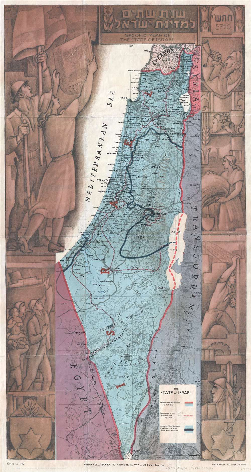
Second Year of the State of Israel. / שנת שתיים למדינת ישראל
sold
- Digital Map Information
- Suitable for large format printing
- File Size: 9.69 MB
- File Type: ZIP / TIFF
- ICC color profile embedded
- Delivered instantly via download link
A rare and stunning 1949 Joseph Szapiro (Schapiro) Zionist map of Israel, with striking Social Realist imagery, celebrating the second year after its founding in 1947.The map depicts the region from the Mediterranean Sea to Jordan (Transjordan) and Syria and from Lebanon to Egypt and the Gulf of Eilat (Gulf of Aqaba). Highly detailed, cities, towns, and villages are labeled throughout, with Jerusalem and Tel Aviv given prominence. (more details)
An early American map of the California coastline that predates the California Gold Rush.

[Untitled]. June 19, 1847 Adjutant's Office, Monterey, California.
sold
- Digital Map Information
- Suitable for large format printing
- DPI: 300
- File Size: 3.24 MB
- File Type: ZIP / TIFF
- ICC color profile embedded
- Delivered instantly via download link
This is an 1847 map of the California coastline from Sonoma to San Diego. Though sparsely illustrated, each of the major army forts along the coast are labeled, including Santa Clara, Monterey, San Luis Obispo, Santa Barbara, Angeles (Los Angeles), and San Diego. The route to travel between these forts is illustrated by a dotted line. A table in the lower left corner gives the distances between these forts and the number of men stationed at each one and also notes that the Mormon Battalion is not included in the numbers of men stationed at the forts because their term of enlistment 'expires in July'. An inset map of Lower (Baja) California is situated in the lower right corner and illustrates the peninsula from north of Loreto to La Paz, where the U.S. Army maintained a fort defended by 111 soldiers. (more details)
Depicts the 'Great Circle' - verso covered in military aviation information.

Global Map for Global War and Global Peace.
sold
- Digital Map Information
- Suitable for large format printing
- File Size: 21.14 MB
- File Type: ZIP / TIFF
- ICC color profile embedded
- Delivered instantly via download link
This is a 1943 Antonio Petruccelli and Aluminum Company of America map of the world. The map utilizes the Azimuthal Equidistant Projection, or the North Pole Projection. Created with the purpose of illustrating true distances traveled by air, this ... (more details)
Highlights the actions of General William Worth's column in the capture of Mexico City during the Mexican-American War.

Sketch of the route of General Worth's Column from Chapultepec to the Alameda in the attack upon the City of Mexico 13th and 14th September 1847.
sold
- Digital Map Information
- Suitable for large format printing
- DPI: 300
- File Size: 2.16 MB
- File Type: ZIP / TIFF
- ICC color profile embedded
- Delivered instantly via download link
This is an 1847 John Clifford Pemberton map of the actions of September 13th and 14th, 1847 that were part of the Battle of Mexico City during the Mexican-American War. The map depicts the region from the Chapultepec Castle to the Alameda in Mexico City and from a Mexican battery north of the city to Tacubaya. Since Pemberton served on General William J. Worth's staff, the map highlights the movements of Worth's column as it moved up the western aqueduct toward the San Cosme Gate (labeled here as position A). Generals Worth and Quitman each took a different aqueduct into the city, but Worth's column was able to break through the San Cosme Gate before Quitman's men could break through the resistance at the Belin Gate, meaning Worth's column entered the city first, and effectively ended the Mexican-American War. (more details)
Took place north of Chihuahua, Mexico and was a brilliant victory for the Americans.

Sketch of the Battle of Sacramento Feb. 28th, 1847.
sold
- Digital Map Information
- Suitable for large format printing
- DPI: 300
- File Size: 3.2 MB
- File Type: ZIP / TIFF
- ICC color profile embedded
- Delivered instantly via download link
This is an 1847 U.S. Government map of the Battle of the Sacramento River, Chihuahua, Mexico, during the Mexican-American War. The map illustrates the battlefield from the Cerro Sacramento to the Arroyo Seco and from the Sierra de Nombre de Dios to Torreon. Highly detailed, the map illustrates the many maneuvers undertaken by both American and Mexican troops. The positions of American and Mexican troops are traced, as is the advance of the American artillery. Most of these movements are labeled, though in the chaos it can be difficult to know exactly what action is being depicted. Twelve different locations are identified alphabetically, which corresponds to a key situated at the lower left. The note at bottom right perhaps summarizes all that one needs to know about this battle: the Mexicans outnumbered the Americans by more than four to one, yet only one American was killed, with the Mexicans suffering 300 dead. (more details)
Took place in the modern-day cities Whittier, Pico Rivera, and Montebello, CA about ten miles south of downtown Los Angeles.
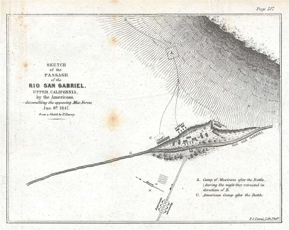
Sketch of the Passage of the Rio San Gabriel, Upper California, by the Americans, - discomfiting the opposing Mex. Forces, Jan. 8th 1847.
sold
- Digital Map Information
- Suitable for large format printing
- DPI: 300
- File Size: 1.21 MB
- File Type: ZIP / TIFF
- ICC color profile embedded
- Delivered instantly via download link
This is an 1847 William Hemsley Emory map of the Battle of Rio San Gabriel during the Mexican-American War, which took place in parts of modern-day Whittier, Pico Rivera, and Montebello, California, about ten miles south of downtown Los Angeles. The Rio San Gabriel (San Gabriel River) bisects the map and was the focus of this engagement between the American force led by Commodore Robert Stockton and the Californian contingent under the command of José María Flores. The American force had set out from San Diego on December 29th, with the goal of reaching a besieged American force in Los Angeles. On January 8th, at two-thirty in the afternoon after marching eleven- and one-half miles, Stockton and his men reached the Rio San Gabriel. As the American approached the river, they formed into a square, believing this to be the most effective defense against a mounted enemy. An advance group from the Californian force began harassing them even trying (unsuccessfully) to drive a group of wild mares into the Americans. The Mexican artillery occupied the high ground on the far side of the river, which did not provide the best fire for the Mexicans, even though they held the high ground. The Americans successfully forded the river and brought their own artillery to bear against the Mexicans, who, faced with superior firepower, withdrew to the north, closer to Los Angeles. (more details)