
An extremely rare Greek view of the Greek invasion of the island of Chios in the Aegean Sea during the First Balkan War.

ΕΚ ΤΟΥ ΕΛΛΗΝΟΤΟΥΡΚΙΚΟΥ ΠΟΛΕΜΟΥ ΤΟΥ 1912-19-1 3 Η ΚΑΤΑΛΗΨΙΣ ΤΗΣ ΧΙΟΥ ΚΑΙ Ο ΒΟΜΒΑΡΔΙΣΜΟΣ ΤΟΥ ΤΟΥΡΚΙΚΟΥ ΣΤΡΑΤΟΥ ΥΠΟ ΤΟΥ ΕΔΔΗΝΙΚΟΥ ΣΤΟΔΟΥ ΤΗ 11 ΝΟΕΜΒΡΊΟΥ 1912. / La Guerre Greco-Turque de 1912-1913 L'Occupation de l'Ile de Chio et le Bombardement de l'Armée Turque par l'Escadre Hellenique, le 11/24 Novembre 1912.
sold
- Digital Map Information
- Suitable for large format printing
- File Size: 19.85 MB
- File Type: ZIP / TIFF
- ICC color profile embedded
- Delivered instantly via download link
This is a 1913 Greek chromolithograph view of the invasion of the island of Chios during the First Balkan War. The view illustrates Greek troops landing on the beaches of Chios and meeting the opposing Turkish army head-on, with Greek troops continuing forward in ... (more details)
An unusual map of the world in three sections - mapping the South Pole, North Pole, and the regions between the Tropics.
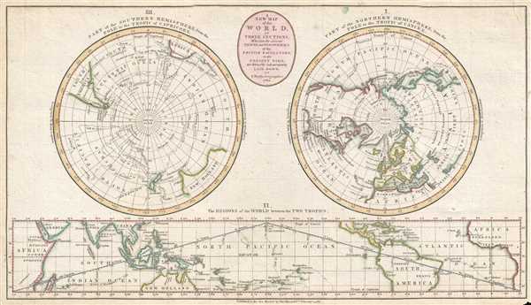
A New Map of the World in Three Sections; Wherein the Several Tracks and Discoveries of the British Navigators to the Present Time are distinctly and accurately Laid Down.
sold
- Digital Map Information
- Suitable for large format printing
- DPI: 300
- File Size: 4.33 MB
- File Type: ZIP / TIFF
- ICC color profile embedded
- Delivered instantly via download link
This is a 1782 John Bayly map of the world in three sections. Two of the three sections are circular, hemispheric projections depicting the world from the North Pole and the South Pole, respectively. The third section is a strip map situated along the bottom of ... (more details)
Labels the Eastern Sea, though as part of the East China Sea.
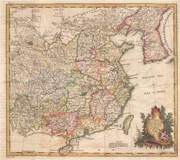
China as Surveyed by the Jesuit Missionaries between the Years 1708 and 1717 with Korea and the ajoining Parts of Tartary.
sold
- Digital Map Information
- Suitable for large format printing
- DPI: 300
- File Size: 3.7 MB
- File Type: ZIP / TIFF
- ICC color profile embedded
- Delivered instantly via download link
This is a 1747 Thomas Kitchin map of China. The map depicts the region from Yunnan to the East China Sea and from Mongolia and Korea to Hainan. Exquisitely engraved, myriad cities, towns, and villages throughout China are labeled, including Beijing (Peking), Guangzhou (Canton), and Nanjing (Nan-King). The Great Wall of China is also illustrated traversing northern China near Beijing. Cartographically, the map is based on early maps by Jean Baptiste Bourguignon d'Anville, note in particular D'Anville's characteristic shaping of the Korean Peninsula. The Kingdom of Korea is also labeled Lau-Li-Qua, which is quite unusual. The body of water east of Korea remains unlabeled, which is significant as there is a debate between naming it the East Sea, the Sea of Korea, or the Sea of Japan. Curiously, here the Eastern Sea is labeled, but further to the south as part of the East China Sea, which today is not part of this dispute. (more details)
A detailed map of the central part of Barnstable County on Cape Cod.

Massachusetts Atlas. Plate No. 9.
sold
- Digital Map Information
- Suitable for large format printing
- File Size: 8.1 MB
- File Type: ZIP / TIFF
- ICC color profile embedded
- Delivered instantly via download link
This is an 1891 George H. Walker and Company map of part of Barnstable County, Cape Cod, Massachusetts. The map depicts the region from Hyannis to the Atlantic Ocean and from Cape Cod Bay to Nantucket Sound and Monomoy Island. Highly detailed, the towns of ... (more details)
A chart comparing the elevation of the mountains of the world - predates the discovery of Mt. Everest.

Table of the Comparative Heights of the Principal Mountains etc. in the World.
sold
- Digital Map Information
- Suitable for large format printing
- DPI: 300
- File Size: 2.77 MB
- File Type: ZIP / TIFF
- ICC color profile embedded
- Delivered instantly via download link
This is an 1828 example of Anthony Finley's highly sought-after chart of the comparative heights of the principal mountains of the world. The chart details the world's great mountains in relative proximity to one another and divided by continent. Each ... (more details)
Labels the mission 'Tejas' from which Texas got its name.
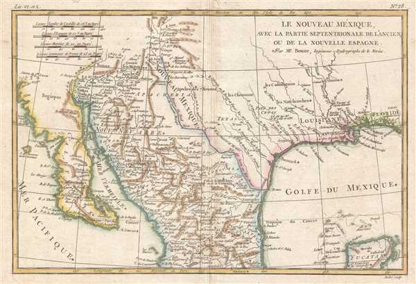
Le Nouveau Méxique, avec la Partie Septentrionale de l'Ancien, ou de la Nouvelle Espagne.
sold
- Digital Map Information
- Suitable for large format printing
- DPI: 300
- File Size: 3.11 MB
- File Type: ZIP / TIFF
- ICC color profile embedded
- Delivered instantly via download link
This is a beautiful c. 1780 Bonne map of northern Mexico and Texas. The map depicts the region from the Pacific Ocean through Mexico, Texas, and Louisiana to western Florida, and extends north as far as the Mission of St. Jeronimo de Taos (just north ... (more details)
Depicts the 'Great Circle' - verso covered in military aviation information.
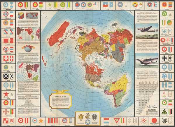
Global Map for Global War and Global Peace.
sold
- Digital Map Information
- Suitable for large format printing
- File Size: 21.52 MB
- File Type: ZIP / TIFF
- ICC color profile embedded
- Delivered instantly via download link
This is a 1943 Antonio Petruccelli and Aluminum Company of America map of the world. The map utilizes the Azimuthal Equidistant Projection, or the North Pole Projection. Created with the purpose of illustrating true distances traveled by air, this ... (more details)
Labels the Land of Liakhov, which is more widely known as the Legendary Ivory Islands.

Asia.
sold
- Digital Map Information
- Suitable for large format printing
- DPI: 300
- File Size: 2.59 MB
- File Type: ZIP / TIFF
- ICC color profile embedded
- Delivered instantly via download link
This is an 1828 Anthony Finley map of Asia. The map depicts the region from the Mediterranean Sea to the Bering Strait and Papua New Guinea and from the Arctic Ocean to Tasmania. It was common during this era in cartographic history to include ... (more details)
Illustrates the territory assigned to each of the Biblical tribes of Israel.
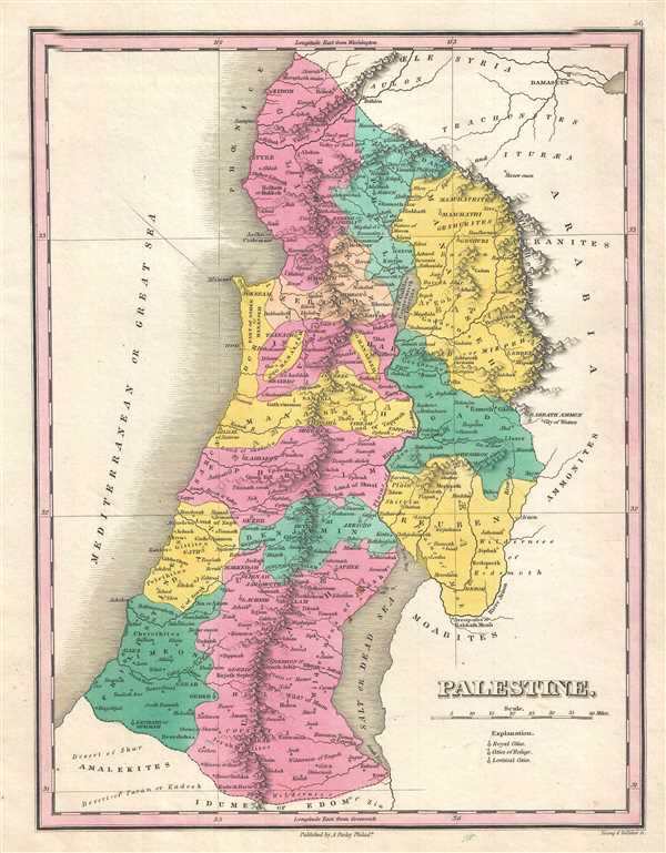
Palestine.
sold
- Digital Map Information
- Suitable for large format printing
- Full resolution TIFF file
- ICC color profile embedded
- Delivered instantly via download link
This is an 1828 Anthony Finley map of Israel, Palestine, or the Holy Land. The map depicts the region from Sidon and Damascus to Zoar at the southern tip of the Dead Sea, including the modern-day nations of Israel, Lebanon, and Palestine, as ... (more details)
A beautiful map of Africa predating the mid-19th century explosion of expeditions to explore the 'Dark Continent'.

Africa.
sold
- Digital Map Information
- Suitable for large format printing
- DPI: 300
- File Size: 2.68 MB
- File Type: ZIP / TIFF
- ICC color profile embedded
- Delivered instantly via download link
This is an 1828 Anthony Finley map of Africa that predates the mid-19th century explosion of European exploration of Africa. The map depicts the entire continent from the Atlantic Ocean to the Horn of Africa and from continental Europe to ... (more details)
Rare early railroad map of New England.
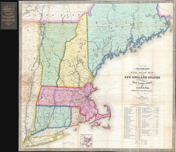
Williams' Telegraph and Rail Road Map of the New England States Eastern Portion of New York State and Canada.
sold
- Digital Map Information
- Suitable for large format printing
- DPI: 300
- File Size: 23.69 MB
- File Type: ZIP / TIFF
- ICC color profile embedded
- Delivered instantly via download link
An extremely rare large format 1852 map of New England published by Alexander Williams and George C. Redding. This was the best railroad map of New England issued following the explosion of railroad construction in the late 1840s. It was prepared to facilitate the first wide scale timely newspaper distribution network in New England. The map covers from the Hudson Valley in Eastern New York to the Maine / New Brunswick border, including all of Massachusetts, Connecticut, Rhode Island, Vermont and New Hampshire, as well as parts of Maine. It provides a detailed breakdown of the rail network as of 1852, including identification of railroad companies, distances, and notes on the construction of the many lines. An inset at bottom center details the Grand Junction Railroad. (more details)
A calendar from 1798 including a view of Merton College in Oxford.

The Oxford Almanack For the Year of our Lord God MDCCXCVIII.
sold
- Digital Map Information
- Suitable for large format printing
- DPI: 300
- File Size: 13.71 MB
- File Type: ZIP / TIFF
- ICC color profile embedded
- Delivered instantly via download link
This is a 1798 Oxford Almanack calendar engraved by James Cole II with a view of Merton College in Oxford, England drawn by Edward Dayes and engraved by James Basire II. Seen from Merton Field, situated north of Merton College, the view depicts St. Alban Hall, which was an independent academic hall owned by the convent of Littlemore until it was purchased by Merton College in 1548 following the dissolution of the convent. It continued as a separate institution until it was annexed by the college in 1881. Cattle are illustrated in the foreground, with students and faculty members shown on a walk next to the wall separating St. Alban Hall from the field. Below the view is a calendar for 1798 that notes holidays and other important dates, including when Oxford and Cambridge terms begin. Above the 1798 calendar, a table of British kings and queens from the Norman conquest by William the Conqueror to George III. The officers of the university, including the chancellor, the vice chancellor, and the proctors. (more details)
Depicts numerous Caribbean islands, including Martinique, Saint Lucia, Puerto Rico, and the Virgin Islands.
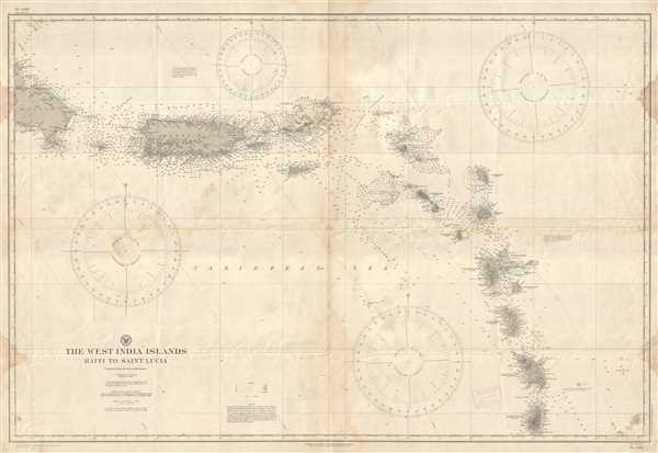
The West India Islands Haiti to Saint Lucia.
sold
- Digital Map Information
- Suitable for large format printing
- File Size: 23.73 MB
- File Type: ZIP / TIFF
- ICC color profile embedded
- Delivered instantly via download link
This is a 1917 U.S. Hydrographic Office nautical chart or maritime map of the Lesser Antilles. The map depicts the region from the extreme eastern part of the Dominican Republic to Saint Lucia and includes Puerto Rico, the Virgin Islands, ... (more details)
A charming and colorful city map of Miami Beach near the end of World War II.

Street Map of Miami Beach.
sold
- Digital Map Information
- Suitable for large format printing
- File Size: 6.94 MB
- File Type: ZIP / TIFF
- ICC color profile embedded
- Delivered instantly via download link
This is a 1945 Miami Beach Chamber of Commerce city map or plan of Miami Beach, Florida. The map depicts the city from Biscayne Bay and the Intracoastal Waterway to the Atlantic Ocean and from North Dade County Park to Virginia Key. ... (more details)
An incredible pictorial map of Colorado highlighting the state's history and wildlife.

Colorful Colorado Presents for Your Enjoyment Snow-Capped Mountains - Superb Scenic Regions - Glorious Vacation Playgrounds.
sold
- Digital Map Information
- Suitable for large format printing
- File Size: 11.21 MB
- File Type: ZIP / TIFF
- ICC color profile embedded
- Delivered instantly via download link
This is a 1941 Ray Schmidt pictorial map of Colorado. The map depicts the state from Utah to Kansas and Nebraska and from Wyoming to New Mexico. Beautifully and intricately illustrated, myriad small vignettes populate the entire ... (more details)
A tourist's road map of Florida - ideal for any fishing enthusiast who wants to know where to catch different species of fish.
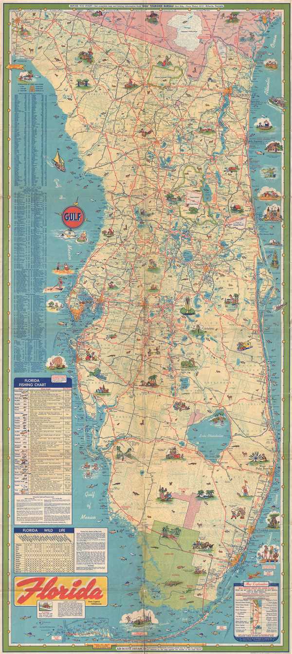
Florida.
sold
- Digital Map Information
- Suitable for large format printing
- File Size: 17.54 MB
- File Type: ZIP / TIFF
- ICC color profile embedded
- Delivered instantly via download link
This is a c. 1950s Rand McNally pictorial road map of Florida designed for the Gulf Oil Corporation. The map depicts the state from Tallahassee and the Gulf of Mexico to the Atlantic Ocean and from Georgia to Key West. Highly ... (more details)
A wonderful pictorial tourist map of the Black Hills that features illustrations of stagecoaches, cowboys, and bison.
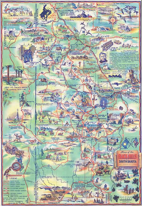
Souvenir Map of the Black Hills of South Dakota: The Sunshine State.
sold
- Digital Map Information
- Suitable for large format printing
- File Size: 16.62 MB
- File Type: ZIP / TIFF
- ICC color profile embedded
- Delivered instantly via download link
This is a 1940 K. Pyle pictorial map of the Black Hills, a small isolated mountain range located in western South Dakota and eastern Wyoming. The map depicts the region from Sundance, Wyoming to Rapid City, South Dakota and ... (more details)
A map of the University of California at Berkeley campus with a handwritten note on verso citing 'Good Looking Women'.

University of California Berkeley Campus.
sold
- Digital Map Information
- Suitable for large format printing
- File Size: 2.49 MB
- File Type: ZIP / TIFF
- ICC color profile embedded
- Delivered instantly via download link
A charming relic from another era, this is a 1942 WWII period campus map of the University of California-Berkeley. The map bears an interesting note on the verso reading 'Camptown Races / Carry me back to Old Virginia / Oh ... (more details)
A map of the southeastern United States published during the American Revolutionary War.
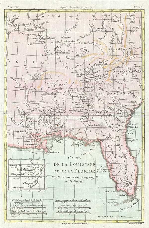
Carte de la Louisiane et de la Floride.
sold
- Digital Map Information
- Suitable for large format printing
- DPI: 300
- File Size: 2.57 MB
- File Type: ZIP / TIFF
- ICC color profile embedded
- Delivered instantly via download link
This is a 1780 Rigobert Bonne and Guillaume Raynal map of Florida, Louisiana, and the Carolinas. The map depicts the region that corresponds to the modern-day states of Florida, Georgia, Alabama, Arkansas, Kentucky, ... (more details)
An early map of the Lincoln Highway - the first transcontinental highway in the United States.

The Lincoln Highway.
sold
- Digital Map Information
- Suitable for large format printing
- File Size: 4.67 MB
- File Type: ZIP / TIFF
- ICC color profile embedded
- Delivered instantly via download link
This is a 1913 Lincoln Highway Association and American Automobile Association map of the proposed route for the Lincoln Highway, what would become the first transcontinental automobile road and the first national memorial to Abraham Lincoln. The map depicts the continental United States from the Pacific Ocean to the Atlantic Ocean and from Canada to Mexico. Highlighted in red and marked by diagonal lines, the original route for the Lincoln Highway stretches from New York to San Francisco and includes the 'Colorado Loop' that was removed from the route a few years later. Numerous other highways are illustrated, and those that are believed to be 'natural tributaries' are indicated by parallel lines drawn through those highways. Myriad cities, towns, and villages are labeled from coast to coast, as are major rivers, lakes, and mountain ranges. (more details)