
Amusing geographical game.

Pirate and Traveler A wolrd Geography Game.
sold
An amusing 1953 geographical board game, Pirate and Traveler , by Milton Bradley. Game play involves drawing a travel card which dictates the journeys that are to be made by the travelers. The distance to be traveled in each move is determined by spinning a ... (more details)
Highly decorative map of New England.
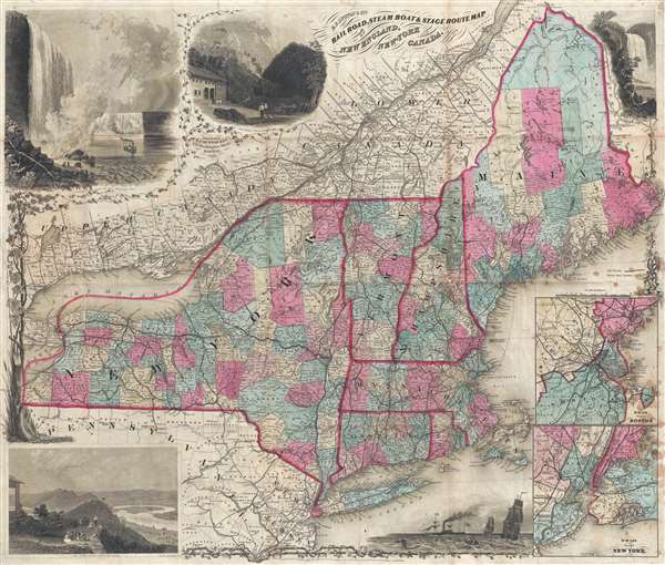
E.P. Dutton and Co.'s Railroad, Steam Boat, and Stage Route Map of New England, New York, and Canada.
sold
- Digital Map Information
- Suitable for large format printing
- File Size: 19.74 MB
- File Type: ZIP / TIFF
- ICC color profile embedded
- Delivered instantly via download link
This is an exceptionally decorative 1866 map of New England and New York issued by Edward Payson Dutton. Centered on Vermont, the map coves from Like Erie to Cape Cod and from Northern Maine to Long Island and New York City. The map was prepared to ... (more details)
Fascinating ephemeral Transmississippi West!
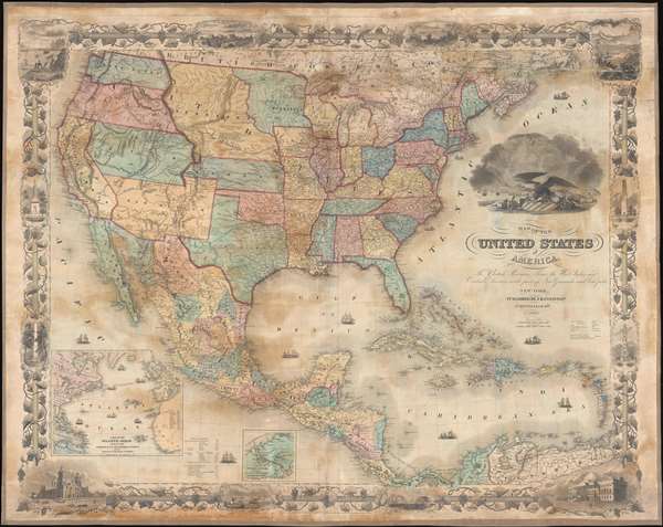
Map of the United States of America, the British Provinces, Mexico, the West Indies, and Central America: with part of New Granada and Venezuela.
sold
- Digital Map Information
- Suitable for large format printing
- File Size: 50.65 MB
- File Type: ZIP / TIFF
- ICC color profile embedded
- Delivered instantly via download link
An exceptionally beautiful map of considerable historic importance, this is J. H. Colton's 1855 map of the United States. The map's coverage extends from Canada to Colombia, inclusive of all of the United States, Mexico, Central America, and the West Indies. It is surrounded by an elaborate grape vine themed decorative border engraved by Bernard. The map itself was engraved by Atwood, and is full of fascinating detail relating to the westward migration and early territorial development of the Transmississippi. (more details)
Scarce map illustrating early fur trading outposts.
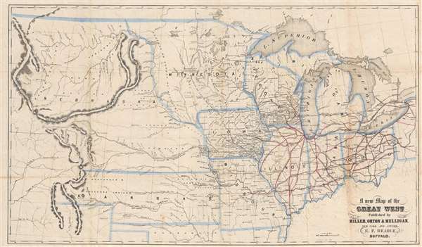
A New Map of the Great West.
sold
- Digital Map Information
- Suitable for large format printing
- File Size: 10.96 MB
- File Type: ZIP / TIFF
- ICC color profile embedded
- Delivered instantly via download link
An uncommon and fascinating map of the American Midwest drawn by Erastus Flavel Beadle in 1856. The map extends from Ohio to the Rocky Mountains and from Canada to Texas' northernmost border, including all of the Great Lakes, and early configurations of Nebraska, Kansas, and Minnesota Territories. East of the Mississippi, the map offers a detailed accounting of the railroad system, with individual lines named. West of the Mississippi, the map focuses on American Indian groups, topography, river systems, and trading posts. The routes taken by John Fremont and Stephen W. Kearny are noted. (more details)
Rare map detailing 11 of Utah's earliest railroads!

Utah. / Cram's Indexed Township County Map and Shipper's Guide of Utah.
sold
- Digital Map Information
- Suitable for large format printing
- File Size: 10.59 MB
- File Type: ZIP / TIFF
- ICC color profile embedded
- Delivered instantly via download link
A highly unusual and rare c. 1900 George F. Cram map of Utah illustrating railroad lines. Covering the entire state of Utah, the map is overprinted in red and updated in manuscript, presumably by the publisher, to illustrate 11 railway lines ... (more details)
The first map to illustrate Wyoming Territory with borders including the Black Hills!
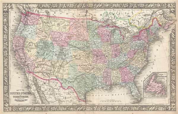
Map of the United States, and Territories. Together with Canada and c.
sold
- Digital Map Information
- Suitable for large format printing
- File Size: 10.79 MB
- File Type: ZIP / TIFF
- ICC color profile embedded
- Delivered instantly via download link
The first map to illustrate the Territory of Wyoming. This is an exceedingly rare intermediate state of Mitchell's map of the United States and the first map to include the territory of Wyoming – 3 years before it's official creation – based upon a failed 1865 congressional act. Although dated 1860, this map represents a transitional variant that appeared only ephemerally between the 1865 and 1866 states – with most of the differences focusing on Wyoming. The map covers the United States from coast to coast and includes parts of adjacent Canada, British America, and Mexico. An inset in the lower right details Newfoundland. (more details)
A bird's-eye view of the White Mountains advertising rail service in the region.
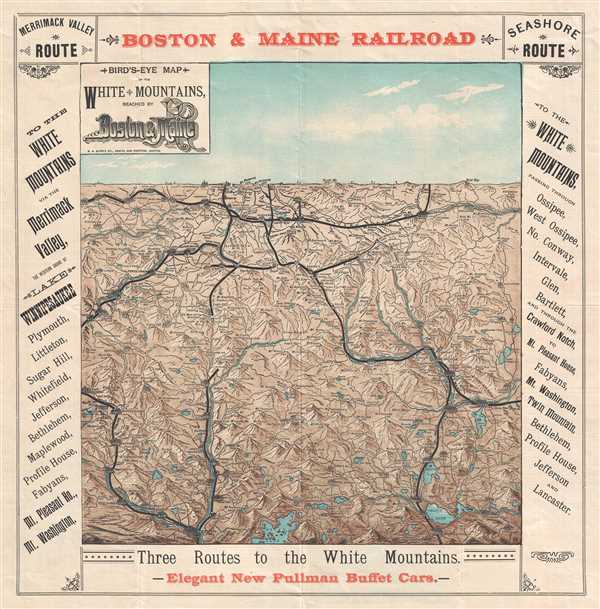
Bird's Eye Map of the White Mountains Reached by Boston and Maine Railroad.
sold
- Digital Map Information
- Suitable for large format printing
- File Size: 6.62 MB
- File Type: ZIP / TIFF
- ICC color profile embedded
- Delivered instantly via download link
This is an 1896 Boston and Maine Railroad bird's eye view map of the White Mountains promoting their service in the area to tourists. The view depicts the region from St. Johnsbury and East Haverhill to Shelburne, Chatham, and Conway Center and from Lancaster and Jefferson Mills to Plymouth and Squam Lake. Beautifully engraved, every mountain in the region is labeled and its elevation is given. Myriad cities, towns, and villages are identified, along with rivers, ponds, and lakes. Railroad routes in the region, including those of the Boston and Maine Railroad and the Maine Central Railroad, are illustrated by thick black lines. The whole is framed by text advertising the Merrimack Valley Route and the Seashore Route operated by the Boston and Maine Railroad to the White Mountains. Red text along the bottom border highlights to new arrival of Pullman buffet cars. At the time, Pullman cars were synonymous with the highest standards of luxury travel. (more details)
A charming pictorial map of animals disembarking from Noah's Ark. Perfect for a child's bedroom!

A Picture Map of Noah's Ark for Children.
sold
- Digital Map Information
- Suitable for large format printing
- File Size: 7.11 MB
- File Type: ZIP / TIFF
- ICC color profile embedded
- Delivered instantly via download link
This is a c. 1930s pictorial children's map of the Noah's Ark bible story. The map illustrates the end of the story, after Noah saves a pair of every species of animal and sails in an ark for forty days and nights. Noah can be seen waving ... (more details)
Pictorial Map of Historic Deerfield.
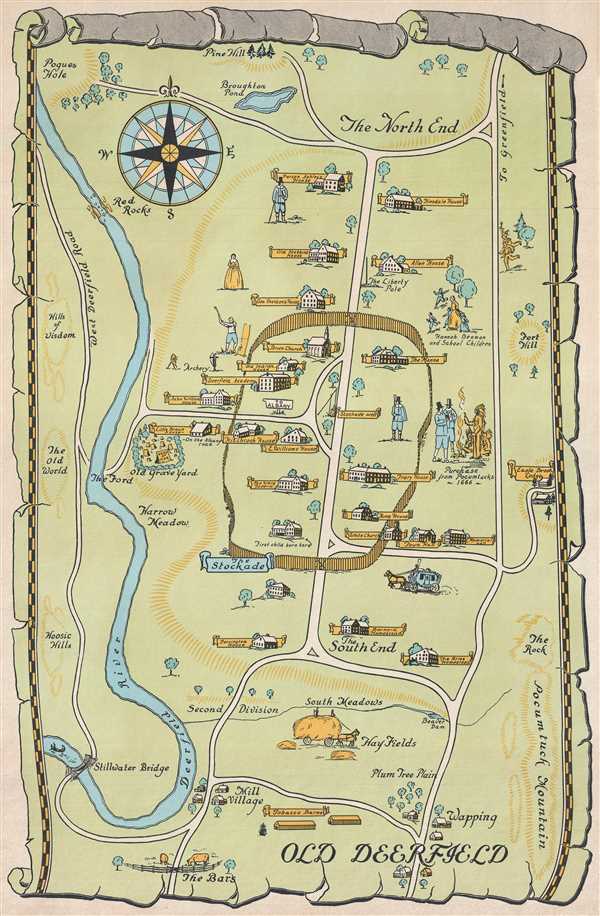
Old Deerfield.
sold
- Digital Map Information
- Suitable for large format printing
- File Size: 5.9 MB
- File Type: ZIP / TIFF
- ICC color profile embedded
- Delivered instantly via download link
This is a c. 1940s pictorial map of Historic Deerfield (Old Deerfield), Massachusetts. The map depicts the town from The North End to The Bars and from the Deerfield River to Pocumtuck Mountain. Beautifully illustrated, each historic home ... (more details)
Traces operational and proposed air mail routes and locates airfields and U.S. Naval Air Stations at the beginning of World War I

Manufacturers Aircraft Association Map of the United States Showing Aviations Fields.
sold
- Digital Map Information
- Suitable for large format printing
- File Size: 3.9 MB
- File Type: ZIP / TIFF
- ICC color profile embedded
- Delivered instantly via download link
This is a 1917 J.N. Matthews Company and Manufacturers Aircraft Association map of the United States illustrating airfields and naval air stations at the outbreak of World War I. The map depicts the continental United States from the Pacific Ocean to the Atlantic Ocean and from Canada to Mexico.
Illustrating the beginning of American aviation, the focus here is on the creation of an air mail system. Both proposed and operational air mail routes are indicated by thick red lines; proposed lines are noted by dashed lines and the only operational line between New York and Washington, D.C. is noted by a solid line. Aerial distances between the proposed hubs for air mail service are noted above the lines by large numbers. Thinner red lines illustrate air routes between important cities throughout the country and aerial distances between these cities are also given. At table in the lower left corner lists the fifty-six airfield and naval air stations noted on the map alphabetically. Each airfield or naval air station is marked by a square and identified by a number on the map, which correspond to the number next to the name of a given airfield or naval air station in the table.
Myriad cities and towns are labeled throughout the United States, with state capitals and other major cities labeled in bold. The nation's railway network is also illustrated, and each line is identified by the company operating over those rails. The Rocky Mountains and the Sierra Nevada Mountains are illustrated and labeled, as are all five Great Lakes. (more details)
Illustrating the beginning of American aviation, the focus here is on the creation of an air mail system. Both proposed and operational air mail routes are indicated by thick red lines; proposed lines are noted by dashed lines and the only operational line between New York and Washington, D.C. is noted by a solid line. Aerial distances between the proposed hubs for air mail service are noted above the lines by large numbers. Thinner red lines illustrate air routes between important cities throughout the country and aerial distances between these cities are also given. At table in the lower left corner lists the fifty-six airfield and naval air stations noted on the map alphabetically. Each airfield or naval air station is marked by a square and identified by a number on the map, which correspond to the number next to the name of a given airfield or naval air station in the table.
Myriad cities and towns are labeled throughout the United States, with state capitals and other major cities labeled in bold. The nation's railway network is also illustrated, and each line is identified by the company operating over those rails. The Rocky Mountains and the Sierra Nevada Mountains are illustrated and labeled, as are all five Great Lakes. (more details)
The first printing of the most authoritative and influential map of the siege of the British Legation in Peking (Beijing) during the Boxer Rebellion. Printed in Beijing!

Plan of British Legation Peking shewing defences June to August 1900.
sold
- Digital Map Information
- Suitable for large format printing
- File Size: 6.79 MB
- File Type: ZIP / TIFF
- ICC color profile embedded
- Delivered instantly via download link
An otherwise unobtainable rarity of the utmost historical importance produced in Beijing in the aftermath of the 1900 Boxer Rebellion (Yihetuan Movement, 義和團運動). This is the first, largest, and best official map Beijing's British Legation to illustrate the events of the Boxer Rebellion (1899 - 1901) and the siege of the Legation Quarter.
The map is the product of meticulous on-site surveys and post-siege interviews conducted by British Engineer Henry Edward Colvin Cowie. When the Boxer Rebellion laid siege to the Beijing Legation Quarter, Cowie was drafted from his civilian position with the Indian Public Works Department and sent to Beijing as part of the Bombay Sappers and Miners contingent of the China Relief Expedition. The map was printed on site and bears the Bo. S. and M. (Bombay Sapper's and Miners) imprint, suggesting it was printed with field lithography equipment carried with the Relief Expedition. This is thus the first printing of Cowie's important map and is the source of several subsequent editions which appeared in various influential books and articles on the Boxer Rebellion.
Lithograph signatures of both Lieut. H.E.C. Cowie, and his superior, Lieutenant Colonel George Kenneth Scott-Moncrieff, appear in the lower right. It is also signed in manuscript by Captain Francis Garden Poole (1870 - 1950), an important figure in the defense of the British Legation, this providing the map with an excellent provenance. (more details)
The map is the product of meticulous on-site surveys and post-siege interviews conducted by British Engineer Henry Edward Colvin Cowie. When the Boxer Rebellion laid siege to the Beijing Legation Quarter, Cowie was drafted from his civilian position with the Indian Public Works Department and sent to Beijing as part of the Bombay Sappers and Miners contingent of the China Relief Expedition. The map was printed on site and bears the Bo. S. and M. (Bombay Sapper's and Miners) imprint, suggesting it was printed with field lithography equipment carried with the Relief Expedition. This is thus the first printing of Cowie's important map and is the source of several subsequent editions which appeared in various influential books and articles on the Boxer Rebellion.
Lithograph signatures of both Lieut. H.E.C. Cowie, and his superior, Lieutenant Colonel George Kenneth Scott-Moncrieff, appear in the lower right. It is also signed in manuscript by Captain Francis Garden Poole (1870 - 1950), an important figure in the defense of the British Legation, this providing the map with an excellent provenance. (more details)
The first, best, and earliest map of the Defense of the Legation Quarter during the Boxer Rebellion - original Cyanotype printed in Beijing shortly after the events described.

Defence of Foreign Legations, Peking, China, June 20th to Aug. 14th, 1900.
sold
- Digital Map Information
- Suitable for large format printing
- File Size: 26.9 MB
- File Type: ZIP / TIFF
- ICC color profile embedded
- Delivered instantly via download link
A rarity of the utmost historical importance produced in Beijing in the aftermath of the 1900 Boxer Rebellion (Yihetuan Movement, 義和團運動). This is the first, largest, and best official map Beijing's Legation Quarter (Dong Jiaomin Xiang / 東交民巷) to illustrate the events of the Boxer Rebellion (1899 - 1901) and the siege of the Foreign Legations. The map was prepared by the American military engineer Harley Bascom 'Fergie' Ferguson, who was sent to Beijing in 1900 as part of the China Relief Expedition, a multinational emergency force mustered to liberate the besieged legations and suppress the Boxer Rebellion. Produced in cyanotype (blueprint) with Ferguson's own manuscript annotations, this map was issued in miniscule quantities intended only for distribution among military and civilian officials in Beijing – there are only three surviving examples known. Due to the meticulousness and accuracy in illustrating daily progression of the battle, Ferguson's map is today the basis for all subsequent maps of the Legation Quarter's defense. (more details)
Extremely scarce map of the defense of the Legation Quarter during the Boxer Rebellion.
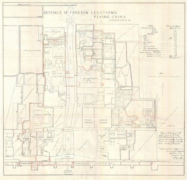
Defence of foreign legations, Peking, China, June 20th to Aug. 14th, 1900.
sold
- Digital Map Information
- Suitable for large format printing
- File Size: 7.69 MB
- File Type: ZIP / TIFF
- ICC color profile embedded
- Delivered instantly via download link
A rare 1901 map of the Legation Quarter (Dong Jiaomin Xiang / 東交民巷) of Peking or Beijing, China, laying out the defense of the Foreign Legations during the Boxer Rebellion. The map identifies the various legations: Spanish, Japanese, Russian, Italian, German, British, United States, as well as Chinese residents and some commercial establishments. At the southern end of the map the Tartar Wall is identified; at the northern end, the wall of the Forbidden City. Produced from a map compiled by Harley Bascom 'Fergie' Ferguson (1875-1968), Chief Engineering Officer of the 1st Engineers Corps, the map has been further annotated in red and blue to show barricades, tunnels, ditches, walls, mines, burnt houses, bomb proof sites, and other lines of defense. Ferguson was sent to China with the China Relief Expedition of 1901, an eight-nation alliance conceived to rescue foreign nationals in the Legation Quarter. (more details)
One of the iconic maps of the golden age of Pictorial Maps.

A Map and History of Peiping; formerly known as Peking; capital of provinces, princedoms, and kingdoms since 1121 B.C.; in 1264 A.D. the capital of the Mongol Empire of Kublai Khan; made the capital of the Ming Empire and built as it is today by Yung Lo in 1421; continued as the capital of the Chinese Empire through the Ming and Ching Dynasties; and now a city which will live long in the memory of man as one of the greatest the world has ever known. Completed on this fifth day of February in the year of our Lord Nineteen Hundred and Thirty-six.
sold
- Digital Map Information
- Suitable for large format printing
- File Size: 33.74 MB
- File Type: ZIP / TIFF
- ICC color profile embedded
- Delivered instantly via download link
A first edition example of Frank Dorn's iconic 1936 chromolithograph pictorial map of Beijing or Peking, China. It is considered one of the great maps from the Golden Age of Pictorial Cartography. The map captures Beijing in the days leading up to World War II (1939 - 1945) - though by this time, China was already at odds with Japan, and the Second Sino-Japanese War (1937 - 1945), a precursor to WWII in Asia, was brewing. (more details)
A thematic map tracing the distribution of gangs in Chicago.
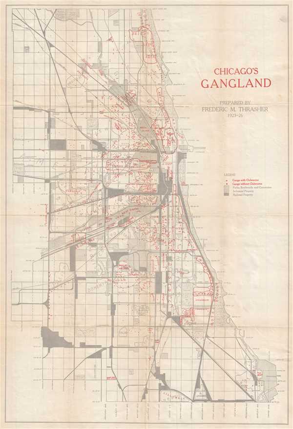
Chicago's Gangland.
sold
- Digital Map Information
- Suitable for large format printing
- File Size: 6.7 MB
- File Type: ZIP / TIFF
- ICC color profile embedded
- Delivered instantly via download link
This is a 1927 Frederic Milton Thrasher map of Chicago tracing the distribution of gangs throughout the city. The map depicts the city from Austin Avenue to Lake Michigan and from Bryn Mawr Avenue to 95th Street. Created for his magnum ... (more details)
Important Moon map made for the Apollo 11 Lunar Landing.

Engineer Special Study of the Surface of the Moon, Generalized Photogeologic Map of the Moon.
sold
- Digital Map Information
- Suitable for large format printing
- File Size: 60.87 MB
- File Type: ZIP / TIFF
- ICC color profile embedded
- Delivered instantly via download link
A 1961 landmark study of the Moon made by the U.S. Geological Survey in preparation for the Apollo 11 Lunar Landing Mission. Represents the near side of the Moon on a scale of 1:3,800,000. This spectacular monumentally proportioned map ... (more details)
Important Moon map made for the Apollo 11 Lunar Landing.
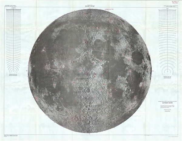
Engineer Special Study of the Surface of the Moon, Lunar Rays.
sold
- Digital Map Information
- Suitable for large format printing
- File Size: 64.17 MB
- File Type: ZIP / TIFF
- ICC color profile embedded
- Delivered instantly via download link
A 1961 landmark study of the Moon made by the U.S. Geological Survey in preparation for the Apollo 11 Lunar Landing Mission. Represents the near side of the Moon on a scale of 1:3,800,000. This spectacular monumentally proportioned map ... (more details)
Important Moon map made for the Apollo 11 Lunar Landing.

Engineer Special Study of the Surface of the Moon, Physiographic Divisions of the Moon.
sold
- Digital Map Information
- Suitable for large format printing
- File Size: 62.02 MB
- File Type: ZIP / TIFF
- ICC color profile embedded
- Delivered instantly via download link
A 1961 landmark study of the Moon made by the U.S. Geological Survey in preparation for the Apollo 11 Lunar Landing Mission. Represents the near side of the Moon on a scale of 1:3,800,000. This spectacular monumentally proportioned map ... (more details)
Illustrates the city of New Amsterdam from its incorporation to its surrender to the English.
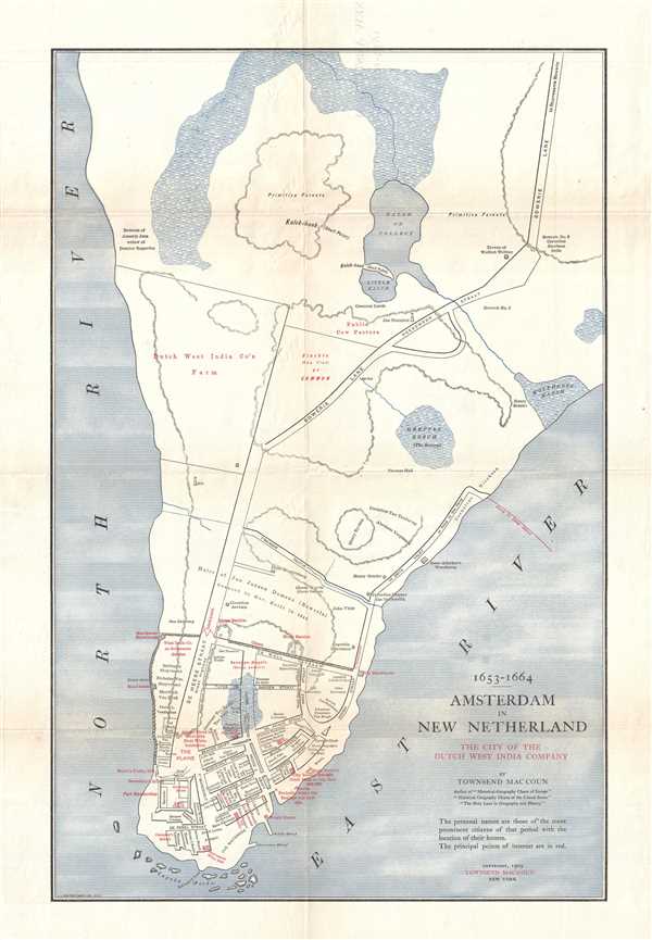
1653 - 1664 Amsterdam in New Netherland The City of the Dutch West India Company.
sold
- Digital Map Information
- Suitable for large format printing
- Full resolution TIFF file
- ICC color profile embedded
- Delivered instantly via download link
This is a 1909 Townsend MacCoun city map or plan of the colony of New Amsterdam, now known as New York City, between 1653 and 1664. Located on the southern tip of Manhattan, the map depicts the region from the Hudson River to the East River and from Midtown to the Battery. The colony itself, however, is confined to the southernmost extreme of Manhattan from Wall Street to the Battery. Streets are illustrated and labeled throughout the settlement, as is Fort Amsterdam and the Wall that gave Wall Street its name. the residences of prominent citizens are labeled within the settlement as well, as are numerous other 'points of interest'. Outside the walls, several farms are labeled by the owner's name (including the Dutch West India Company Farm), along with streets, a mill, and Wolfert Webber's tavern. (more details)
Blends the past and the present together while commemorating Henry Hudson's voyage of exploration up the Hudson River.
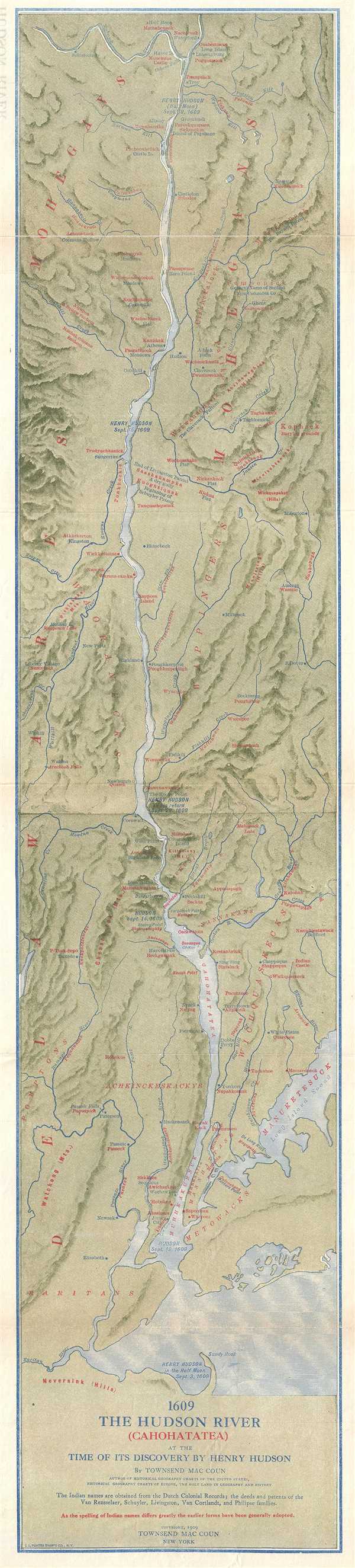
1609 The Hudson River (Cahohatatea) at the Time of its Discovery by Henry Hudson
sold
- Digital Map Information
- Suitable for large format printing
- File Size: 9.2 MB
- File Type: ZIP / TIFF
- ICC color profile embedded
- Delivered instantly via download link
This is a 1909 Townsend MacCoun map of the Hudson River and its environs as they would have looked when Henry Hudson first ascended the river in 1609. Blending sites along the river from 1609 and 1909, the map depicts the region from ... (more details)