
Wonderful, charming idiosyncratic map of Beijing and Tianjin issued in China at the end of the Second Sino-Japanese War.

Polyglot Map of Peiping for Travellers or as Memo. / Polyglot Map of Tientsin.
sold
- Digital Map Information
- Suitable for large format printing
- File Size: 21.15 MB
- File Type: ZIP / TIFF
- ICC color profile embedded
- Delivered instantly via download link
A remarkable idiosyncratic multi-lingual discovery, this is a rare 1945 multi-colored broadsheet mimeograph map of Beijing (Peiping) and Tianjin (Tientsin), China. The map comprises of our maps printed back to back on a single sheet. The upper map, or recto, in ... (more details)
Wonderful map of Yokohama when it was the most international city in Japan.
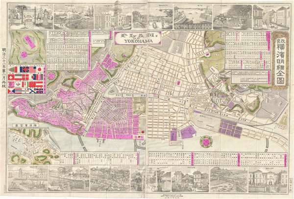
改良横濱明細全図 / Plam of Yokohama.
sold
- Digital Map Information
- Suitable for large format printing
- File Size: 17.38 MB
- File Type: ZIP / TIFF
- ICC color profile embedded
- Delivered instantly via download link
A colorful and rare Meiji 20 or 1887 Map of Yokohama, Japan by Tomigorō Ozaki (尾崎富五郎). Oriented to the southwest, this map details central Yokohama, at the time most international and industrialized city in Japan, with foreign settlements extending ... (more details)
The famous route of the St. Louis Southwestern Railway.
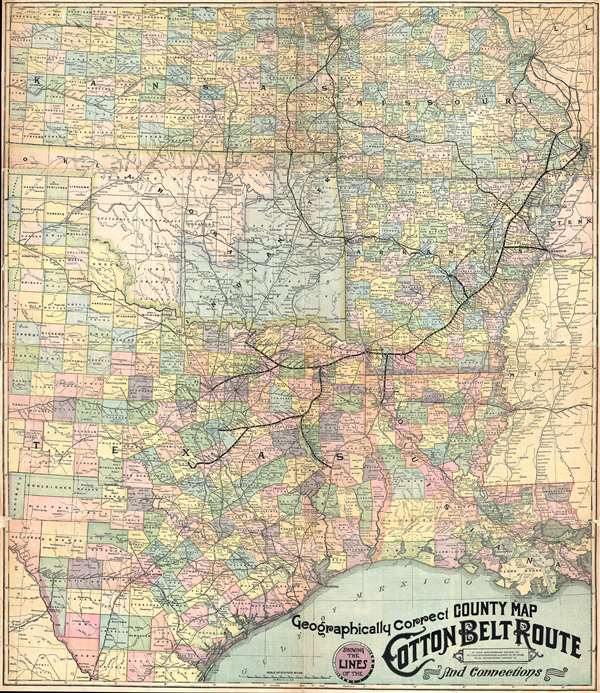
Geographically Correct County Map Showing the Lines of the Cotton Belt Route: St. Louis Southwestern Railway Co., St. Louis Southwestern Railway Co. of Texas, Tyler Southeaster Railway Co., and Connections.
sold
- Digital Map Information
- Suitable for large format printing
- File Size: 30.42 MB
- File Type: ZIP / TIFF
- ICC color profile embedded
- Delivered instantly via download link
This is a c. 1900 St. Louis Southwestern Railway map of what was known as the 'Cotton Belt Route' in the southern United States. The map depicts the central portion of the southern United States including Kansas, Missouri, and southwestern Illinois, Texas, ... (more details)
An iconic map of Shanghai, China, featuring a dramatic panoramic photograph of the Bund.

Saishin Shanhai chizu. Ōsaka Asahi Shinbunsha tokusen. / 大阪朝日新聞社特撰 . 最新上海地圖. / Osaka Asahi Shimbun Special Selection. Newest Map of Shanghai.
sold
- Digital Map Information
- Suitable for large format printing
- File Size: 22.61 MB
- File Type: ZIP / TIFF
- ICC color profile embedded
- Delivered instantly via download link
This is a rare and attractive Showa 7 or 1932 Osaka Asahi Shimbun map of Shanghai, China. Printed in the 7th year of Hirohito's reign (Showa 7), it depicts downtown Shanghai including the Chinese Quarter, the French Concession, the English Quarter (along the Bund), etc. Important buildings along the Bund are carefully noted, including the first HSBC Bank, the British Club, the Palace Hotel (Swatch Art Peace Hotel), Sassoon House (Fairmont Peace Hotel), and the Customs House. There is also a lovely vintage panoramic photo of the Bund along the bottom of the map. A small inset map of Nanjing or Nanking is also included in the lower right quadrant of the map. Another larger inset shows a regional map. Most of the text is written in both Japanese and English. (more details)
Extremely rare depiction of the state of Nebraska extending to Fremont's Peak.

Johnson's Nebraska, Dakota, Colorado, and Kansas.
sold
- Digital Map Information
- Suitable for large format printing
- File Size: 5.62 MB
- File Type: ZIP / TIFF
- ICC color profile embedded
- Delivered instantly via download link
From the 1863 Johnson and Ward edition of the Family Atlas , this is one of the rarest and most desirable states of the Johnson's Dakota, Nebraska and Kansas map. In this example Nebraska is depicted with a long panhandle extending from Iowa all the way ... (more details)
Gorgeous example of the mountains and rivers chart.
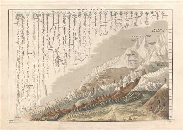
Physical Geography.
sold
- Digital Map Information
- Suitable for large format printing
- DPI: 300
- File Size: 4.18 MB
- File Type: ZIP / TIFF
- ICC color profile embedded
- Delivered instantly via download link
A fine example of Adam and Charles Black's 1840 comparative mountains and rivers of the world chart. Charts of this kind were first introduced in England around 1823 and became a common feature in atlases throughout the 19th century. The present example ... (more details)
Incredible early map of Golden Gate Park - only the eastern third has been improved!

Map Showing the Golden Gate Park, the Avenue, and Buena Vista Park
sold
- Digital Map Information
- Suitable for large format printing
- File Size: 8.08 MB
- File Type: ZIP / TIFF
- ICC color profile embedded
- Delivered instantly via download link
This is an 1893 Joseph Britton and Jacques Joseph Rey map of Golden Gate Park. The map depicts Golden Gate Park from the Pacific Ocean to Baker Street and from D Street to H Street and includes both The Panhandle and Buena Vista Park. When compared with ... (more details)
Incredible hand colored map of Golden Gate Park and Panhandle Park in San Francisco.
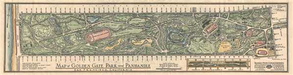
Map of Golden Gate Park and Panhandle, San Francisco, California
sold
- Digital Map Information
- Suitable for large format printing
- File Size: 3.57 MB
- File Type: ZIP / TIFF
- ICC color profile embedded
- Delivered instantly via download link
This is a 1943 Hugh Mooney map of Golden Gate Park in San Francisco, California. The map depicts the park from Stanyan Street to the Pacific Ocean and from Fulton Street to Lincoln Way. Beautifully hand colored, Golden Gate Park is presented in detail ... (more details)
Features photographs of the devastation caused by the earthquake and ensuing fires on verso.

Panorama of San Francisco, Prior to April 18, 1906.
sold
- Digital Map Information
- Suitable for large format printing
- File Size: 12.23 MB
- File Type: ZIP / TIFF
- ICC color profile embedded
- Delivered instantly via download link
This is a 1906 C. Weidner photographic panorama map or view of San Francisco, California. The map depicts San Francisco from Telegraph Hill to the Call Building and from San Francisco across San Francisco Bay. On the opposite side of the bay, ... (more details)
Held ostensibly to celebrate the completion of the Panama Canal, many in San Francisco viewed the exposition as a way to showcase the city's recovery following the 1906 earthquake.

Panoramic View of the Panama-Pacific Exposition, Show the Beautiful Island Dotted Bay and the World-Renowned Golden Gate in the Distance.
sold
- Digital Map Information
- Suitable for large format printing
- File Size: 10.24 MB
- File Type: ZIP / TIFF
- ICC color profile embedded
- Delivered instantly via download link
This is a 1916 B. E. Amos map or panoramic view of the Panama-Pacific Exposition in San Francisco, California. The map depicts the exposition grounds from the Inside Inn, a hotel on the Exposition grounds to the Palace of Machinery and from ... (more details)
Detailed map of the White Mountain region in New Hampshire.

Central New Hampshire.
sold
- Digital Map Information
- Suitable for large format printing
- File Size: 13.79 MB
- File Type: ZIP / TIFF
- ICC color profile embedded
- Delivered instantly via download link
This is a 1903 George H. Walker map of the beautiful White Mountains region of central New Hampshire. The map depicts from the Vermont/New Hampshire state line to the Maine/New Hampshire border and from Berlin, New Hampshire to Lake ... (more details)
Depicts the Eiffel Tower, the Louvre, the Arc de Triomphe, and other Paris monuments in profile!
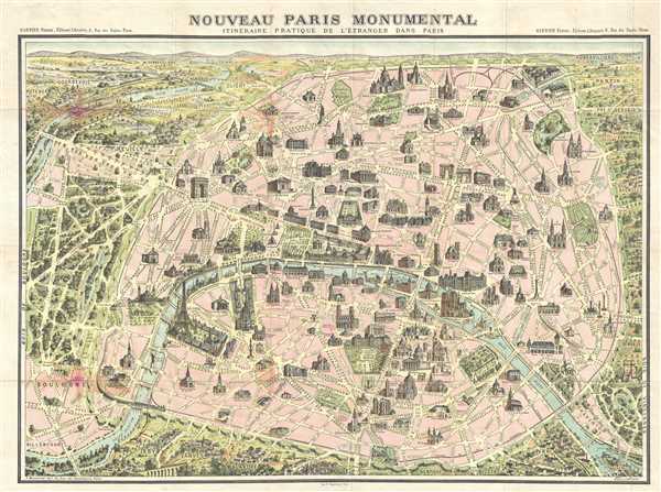
Nouveau Paris Monumental. Itinéraire Pratique de l'Étranger dand Paris.
sold
- Digital Map Information
- Suitable for large format printing
- File Size: 18.26 MB
- File Type: ZIP / TIFF
- ICC color profile embedded
- Delivered instantly via download link
This is an extremely attractive 1900 tourist pocket map of Paris, France. Published by Garnier Freres, this is most likely the 1900 first edition. The map depicts the walled city of Paris and the immediate vicinity from Billancourt ... (more details)
Beautiful and extremely rare plan of Philadelphia while it was still the capital of the United States.
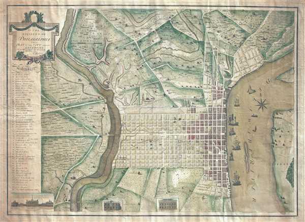
To the Citizens of Philadelphia: This Plan of the City and its Environs is respectfully dedicated by the Editor.
sold
- Digital Map Information
- Suitable for large format printing
- DPI: 300
- File Size: 18.82 MB
- File Type: ZIP / TIFF
- ICC color profile embedded
- Delivered instantly via download link
This is a 1796 Peter Charles Varlé city map or plan of Philadelphia, Pennsylvania. At this point in history, Philadelphia remained the capital of the United States, since the transfer to Washington, D.C. would not take place until ... (more details)
The most complete illustration of Kircher's revolutionary hydro-geographic theories.

Systema Ideale Qvo Exprimitur, Aquarum per Canales hydragogos subterraneos ex mari et in montium hydrophylacia protrusio, aquarumq. subterrestrium per pyragogos canales concoctus.
sold
- Digital Map Information
- Suitable for large format printing
- DPI: 300
- File Size: 11.39 MB
- File Type: ZIP / TIFF
- ICC color profile embedded
- Delivered instantly via download link
This is one of the 17th century polymath Athanasius Kircher's most iconic and graphically intense maps. This map illustrates the subterranean world and is one of the maps included in Kircher's 1665 cosmography Mundus Subterranous ... (more details)
Shows Republic of Texas! One of the earliest known examples of an integrated world map / comparative mountains and rivers charts!
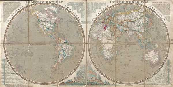
Gilbert's New Map of the World, 1839.
sold
- Digital Map Information
- Suitable for large format printing
- DPI: 300
- File Size: 25.97 MB
- File Type: ZIP / TIFF
- ICC color profile embedded
- Delivered instantly via download link
This is a scarce and fascinating 1839 separate issue James Gilbert and Joshua Archer world map in two hemispheres. The map depicts the world split into the Eastern and the Western hemispheres. Several different intriguing details ... (more details)
A game which was included with a purchase of Weston's English Quality Biscuits in 1933.

The Tarzan Jungle Map and Treasure Hunt
sold
- Digital Map Information
- Suitable for large format printing
- File Size: 8.23 MB
- File Type: ZIP / TIFF
- ICC color profile embedded
- Delivered instantly via download link
This is a 1933 Weston's Quality English Biscuits fantasy game map of Tarzan's Jungle. The map functions as a game board and depicts from the start, which is off the coast of Tarzan's homeland, to the finish, which is, truthfully, ... (more details)
Enormous, impressive, Japanese map of the world.

Zotei yochi kokaizu.
sold
- Digital Map Information
- Suitable for large format printing
- File Size: 69.05 MB
- File Type: ZIP / TIFF
- ICC color profile embedded
- Delivered instantly via download link
An impressive 1875 (Meiji 8) map of the world by Shu Oka. This finely engraved map covers the entire world on Mercator's Projection. The map identifies the routes of various explorers throughout with extensive annotation as well ... (more details)
Extraordinary map depicting the vast railway network in British India at the outbreak of WWI.

Map of Railway Systems in India, Burma, and Ceylon.
sold
- Digital Map Information
- Suitable for large format printing
- File Size: 27.98 MB
- File Type: ZIP / TIFF
- ICC color profile embedded
- Delivered instantly via download link
This is a 1914 Railway Department or Railway Board map of the railway systems in India, Burma, and Sri Lanka (Ceylon). The map depicts the region from Chitral and Kabul (Afghanistan) to Sri Lanka and the Indian Ocean and from ... (more details)
Fascinating Post-Bering Pre-Cook map of the North Atlantic showing Alaska as Island.
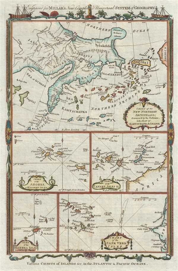
Various Charts of Islands, etc. in the Atlantic and Pacific Oceans.
sold
- Digital Map Information
- Suitable for large format printing
- DPI: 300
- File Size: 2.81 MB
- File Type: ZIP / TIFF
- ICC color profile embedded
- Delivered instantly via download link
This is a 1783 George Henry Millar map of various islands Groups. The map is truly a series of maps printed together on one page, including an early mapping of the Bering Strait and Aleutian Islands, the Azores Islands, the ... (more details)
One of the earliest obtainable maps of Bombay or Mumbai, India.
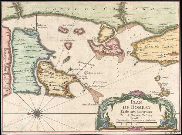
Plan De Bombay et de Ses Environs.
sold
- Digital Map Information
- Suitable for large format printing
- Full resolution TIFF file
- ICC color profile embedded
- Delivered instantly via download link
This is a beautifully hand colored c. 1750 Jacques Nicolas Bellin map of Bombay (Mumbai), India. Bellin's map illustrates Bombay as it was becoming the British East India Company's primary base of operations in India, ... (more details)