

Philipe V. Roy d'Espagne. Buen-retiro. Hermitage de S. Antoine. Entree du Palais Royal a Madrid. La Place Major, de Madrid.
sold
- Digital Map Information
- Suitable for large format printing
- Full resolution TIFF file
- ICC color profile embedded
- Delivered instantly via download link
This is a fine 1701 view of the Royal Palace, Plaza Mayor and the Buen Retiro in Madrid, Spain, by Nicholas De Fer. This beautifully engraved view includes a portrait of Philip V, King of Spain, surrounded by an elaborate and beautiful cartouche. The upper left ... (more details)
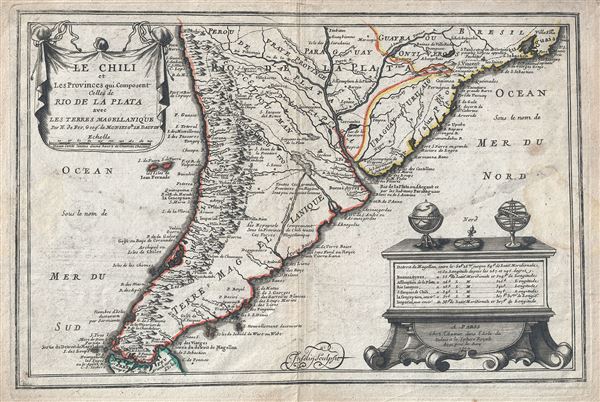
Le Chili et Les Provinces qui Composent Celles de Rio de la Plata avec les Terres Magellanique.
sold
- Digital Map Information
- Suitable for large format printing
- Full resolution TIFF file
- ICC color profile embedded
- Delivered instantly via download link
This is a beautiful 1702 map of southern South America by Nicholas De Fer. It covers from Rio de Janeiro south to the Strait of Magellan and Tierra del Fuego, and includes the modern day nations of Paraguay, Chile, Uruguay and Argentina, with the southern ... (more details)
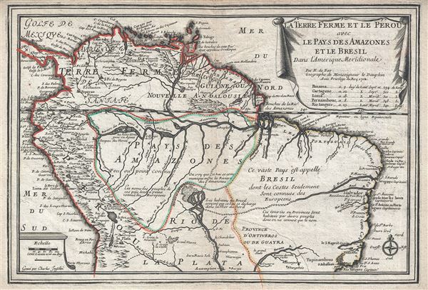
La Terre Ferme et le Perou avec le Pays des Amazones et le Bresil dans l'Amerique Meridionale.
sold
- Digital Map Information
- Suitable for large format printing
- Full resolution TIFF file
- ICC color profile embedded
- Delivered instantly via download link
This is a scarce and beautiful example of Nicholas De Fer's 1702 map of northern South America. It covers from Panama to Rio de Janeiro and renders the entire region in extraordinary detail offering both topographical and political information with ... (more details)

Carte de la Californie suivant. I. La carte manuscrite de l'Amerique de Mathieu Neron Pecci olen dresse a Florence en 1604. II. Sanson 1656. III. De L'Isle Amerique Sept. 1700. IV. le Pere Kino Jesuite en 1705. V. La Societe des Jesuites en 1767.
sold
- Digital Map Information
- Suitable for large format printing
- Full resolution TIFF file
- ICC color profile embedded
- Delivered instantly via download link
This is a rare and important map of California in five different states, ranging from roughly 1656 to 1767. Engraved by the important French cartographer Robert De Vaugondy, for the c.1770 edition of the Denis Diderot (1713-84) Encyclopedie , this ... (more details)
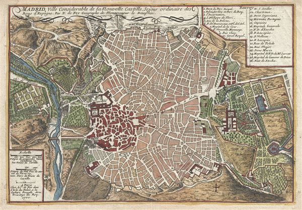
Madrid, Ville Considerable de la Nouvelle Castille.
sold
- Digital Map Information
- Suitable for large format printing
- Full resolution TIFF file
- ICC color profile embedded
- Delivered instantly via download link
This is a beautiful 1700 map or plan of the city of Madrid, Spain by Nicholas De Fer. Centered on the Puerta del Sol, this map covers the center of modern Madrid, Spain's capital city, as well as the surrounding parks, farms, and estates - most of ... (more details)
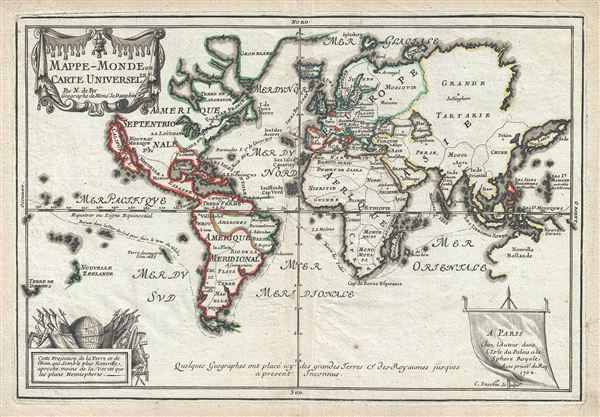
Mappe-Monde ou Carte Universelle.
sold
- Digital Map Information
- Suitable for large format printing
- Full resolution TIFF file
- ICC color profile embedded
- Delivered instantly via download link
This is a scarce and important 1702 Nicholas de Fer map of the world which depicts the entire world according to its 17th century conception. The map is adorned by a beautiful title cartouche in the upper left quadrant and another illustration depicting a globe and flags is featured in the lower left quadrant. Spanish possessions are noted with boundaries color coded in red outline. Routes around the world are illustrated, as are a host of other interesting features. (more details)
Possibly the earliest printed world map to show Australia - well before its recorded discovery!

Pars Orbis.
sold
- Digital Map Information
- Suitable for large format printing
- DPI: 300
- File Size: 37.11 MB
- File Type: ZIP / TIFF
- ICC color profile embedded
- Delivered instantly via download link
This is a scarce and important 1571 map of the world by Benedict Arias Montanus. Finely engraved and prepared for the eight-volume Antwerp Poyglot Bible , this stunning map is considered to by some to be the first printed map to include Australia ... (more details)
Rare maps showing the legendary Mines de St. Barbe.

Les Vieux Mexique ou Nouvelle Espagne avec les costes de la Floride.
sold
- Digital Map Information
- Suitable for large format printing
- Full resolution TIFF file
- ICC color profile embedded
- Delivered instantly via download link
An uncommon 1702 map by Nicolas De Fer of Mexico, the Gulf Coast, and Florida. Centered on the Gulf Of Mexico, this map covers from Baja California to Florida and Cuba, covering in the process, the Gulf of Mexico, parts of New Mexico as far north ... (more details)
Uncommon early map of the West Indies.
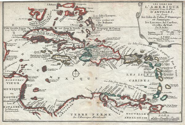
Les Isles de L'Amerique Connues sous le Nom D'Antilles, ou Sont les Isles de Cuba, St. Domingue et Jamaique les Lucayes, les Caribes, et celles du Vent.
sold
- Digital Map Information
- Suitable for large format printing
- Full resolution TIFF file
- ICC color profile embedded
- Delivered instantly via download link
This is a scarce and attractive 1702 map of the West Indies by Nicholas De Fer. It covers the Caribbean from the eastern coast of Yucatan east as far as Barbados and from the southern tip of Florida south to Trinidad and Tobago. Includes Cuba, ... (more details)
Uncommon early map of the East Indies.
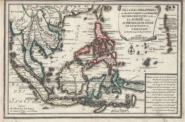
Les Isles Philippines et celles Des Larrons ou de Marianes, Les Isles Moluques et de La Sonde, avec, La Presqu'Isle de l'Inde de la le Gange ou Orientale.
sold
- Digital Map Information
- Suitable for large format printing
- Full resolution TIFF file
- ICC color profile embedded
- Delivered instantly via download link
This is a beautiful and scarce 1702 map of the East Indies by Nicholas De Fer. It covers all of Southeast Asia and the East Indies from the Andaman Islands east to New Guinea and from Taiwan or Formosa south as far as Timor. Includes the ... (more details)

A Cartograph of Treasure Island in San Francisco Bay Golden Gate International Exposition.
sold
- Digital Map Information
- Suitable for large format printing
- Full resolution TIFF file
- ICC color profile embedded
- Delivered instantly via download link
This is an attractive 1940 bird's eye view of Treasure Island in San Francisco Bay, California. Created to depict the fairgrounds of the Golden Gate International Exposition held in 1839 and 1840, the view depicts part of San Francisco in ... (more details)
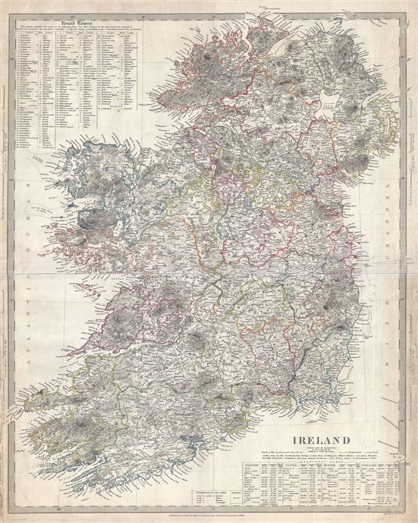
Ireland
sold
This is an appealing 1838 Map of Ireland issued by the Society for the Diffusion of Useful Knowledge, or S.D.U.K. It depicts the entire Emerald divided into 32 counties. It covers from Donegal in the north to Cork in the south. Towns, ... (more details)
Uncommon map presenting Texas at its largest.
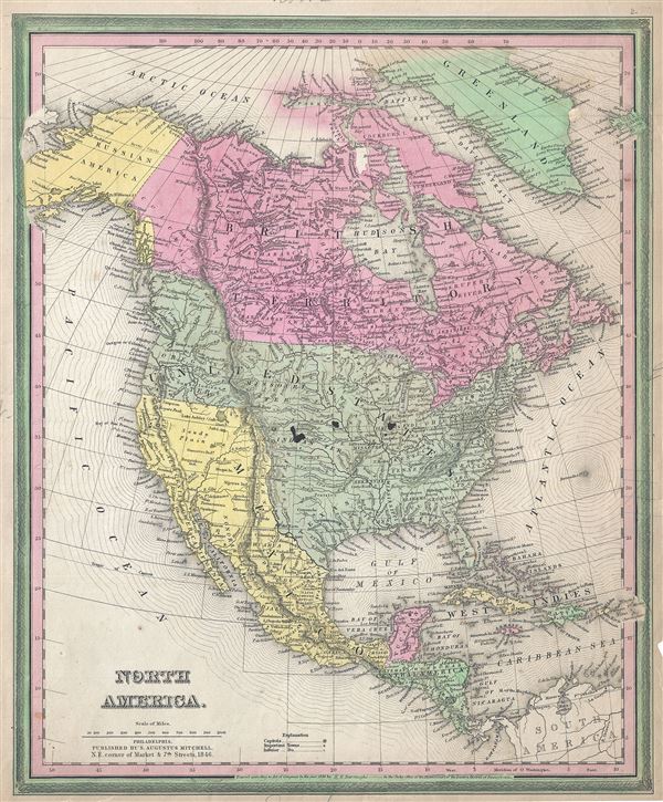
North America.
sold
- Digital Map Information
- Suitable for large format printing
- DPI: 300
- File Size: 8.24 MB
- File Type: ZIP / TIFF
- ICC color profile embedded
- Delivered instantly via download link
This is an important and scarce first edition example of S. A. Mitchell and H. N. Burroughs' 1846 map of North America. This hand colored lithographic map covers all of the United States, Canada, Russian America (Alaska), Mexico and ... (more details)
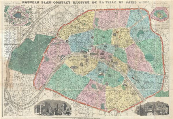
Nouveau Plan Complet Illustre de la Ville de Paris en 1883.
sold
- Digital Map Information
- Suitable for large format printing
- Full resolution TIFF file
- ICC color profile embedded
- Delivered instantly via download link
This is a beautiful 1883 folding map or plan of Paris, France by the French cartographer A. Vuillemin. Centered on the Seine River, it covers embastilled Paris as contained in the Thiers Wall, as well as its immediate vicinity, ... (more details)

Paris Monumental et Metropolitain.
sold
- Digital Map Information
- Suitable for large format printing
- Full resolution TIFF file
- ICC color profile embedded
- Delivered instantly via download link
This extremely appealing c.1920 art deco style pocket map of Paris France by Robelin, combines the virtues of a map and a view. Designed with the tourist in mind, this map covers the embastilled center of Paris and its ... (more details)
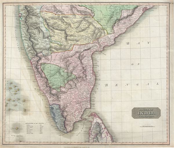
British India, Southern Part.
sold
- Digital Map Information
- Suitable for large format printing
- DPI: 300
- File Size: 17.7 MB
- File Type: ZIP / TIFF
- ICC color profile embedded
- Delivered instantly via download link
This fascinating hand colored 1816 map by Edinburgh cartographer John Thomson depicts southern India. Covers from Bombay in the North to the northern part of Ceylon or Sir Lanka. The map is color coded according to ... (more details)
One of the few early maps to detail the original seven islands of Bombay.
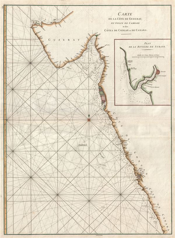
Carte de la Cote de Guzerat, du Golfe de Cambaye et des Cots de Concan et de Canara.
sold
- Digital Map Information
- Suitable for large format printing
- Full resolution TIFF file
- ICC color profile embedded
- Delivered instantly via download link
A scarce 1775 nautical chart or maritime map of the coasts of western Indian in the vicinity of Bombay (Mumbai) and Goa. Composed by Jean-Baptiste d'Apres de Mannevillette, this map covers from Gujarat and the ... (more details)

Rand McNally Indexed Reference Map of San Francisco San Francisco City Map Series.
sold
- Digital Map Information
- Suitable for large format printing
- File Size: 29.2 MB
- File Type: ZIP / TIFF
- ICC color profile embedded
- Delivered instantly via download link
This is a fine c.1940 folding map or plan of the city of San Francisco by Rand McNally. It shows all major streets, parks, cemetery, squares and peaks and covers San Francisco from Fort Point (Golden Gate Bridge) ... (more details)

Map of New York and Vicinity.
sold
- Digital Map Information
- Suitable for large format printing
- File Size: 21.47 MB
- File Type: ZIP / TIFF
- ICC color profile embedded
- Delivered instantly via download link
This is a rare large format 1865 map or plan of New York City by Matthew Dripps. It covers the entire island of Manhattan as well as parts of Brooklyn, Queens, Hoboken and Jersey City. Shows the city in ... (more details)
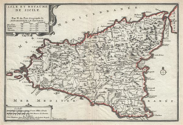
Isle et Royaume de Sicile.
sold
- Digital Map Information
- Suitable for large format printing
- Full resolution TIFF file
- ICC color profile embedded
- Delivered instantly via download link
A beautiful 1701 map of Sicily, Italy by Nicholas De Fer. It covers the Mediterranean Island in its entirety and renders the region in extraordinary detail offering both topographical and political ... (more details)