

La Suisse divisee en ses XIII Cantons et ses Allies.
sold
- Digital Map Information
- Suitable for large format printing
- DPI: 300
- File Size: 11.33 MB
- File Type: ZIP / TIFF
- ICC color profile embedded
- Delivered instantly via download link
This is a beautiful example of Rizzi Zannoni's 1762 decorative map of Switzerland. It covers the entirety of Switzerland divided into its cantons and allies. The map offers excellent detail throughout showing mountains, rivers, forests, national boundaries, ... (more details)
The second major European expedition to northern Japan, Hokkaido, and the Kuril Islands.
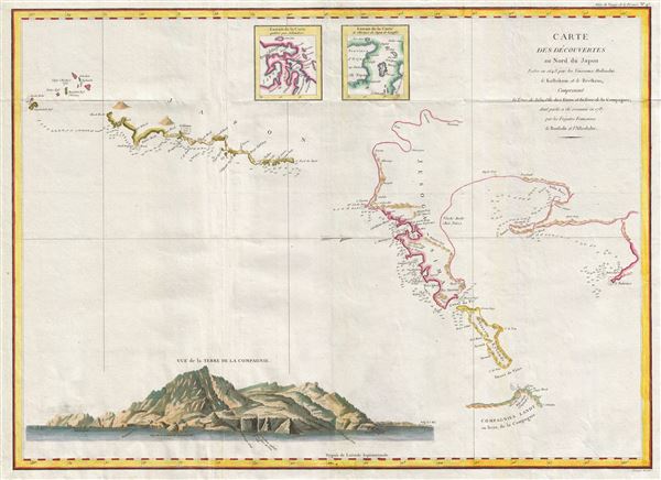
Carte des decouvertes au nord du Japon. Faites en 1643 par les Vaisseaux Hollandais le Kastrikum et le Breskens, comprenant la Terre de Jeso, l'Ile des Etats et la Terre de la Compagnie, dont partie a ete reconnue en 1787 par les Fregates Francaises la Boussole et l'Astrolabe.
sold
- Digital Map Information
- Suitable for large format printing
- DPI: 300
- File Size: 17.22 MB
- File Type: ZIP / TIFF
- ICC color profile embedded
- Delivered instantly via download link
An important 1787 map of northern Japan, Hokkaido, and the Kuril Islands by the French navigator Jean-Francois de Galaup, Comte de Laperouse. Oriented to the west, this map covers from the small islands due south of Yokohama Bay and northwards as far as ... (more details)

l'Italie divisee en ses Differents Etats Royaumes et Republiques.
sold
- Digital Map Information
- Suitable for large format printing
- Full resolution TIFF file
- ICC color profile embedded
- Delivered instantly via download link
This is an appealing decorative 1762 map of Italy by Jean Janvier's. Janvier's map covers from the Gulf of Lyon eastward to include all of Corsica, Sardinia, Italy, the Adriatic, and parts of Hungary and Turkey in Europe. It extends southwards to ... (more details)
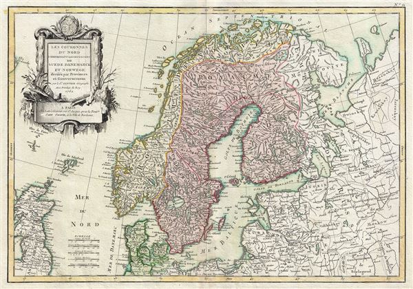
Les Couronnes du Nord Comprenant les Royaumes de Suede Danemarck et Norwege divises par Provinces et Gouvernemens.
sold
- Digital Map Information
- Suitable for large format printing
- Full resolution TIFF file
- ICC color profile embedded
- Delivered instantly via download link
This is a beautiful example of Jean Janvier's 1762 decorative map of Scandinavia. It covers from Iceland and England eastward as far as Moscow, north to the Arctic Sea, and south as far as Denmark and Germany and includes the modern day nations of ... (more details)

Carte des Cotes de Barbarie ou les Royaumes de Maroc, de Fez, d'Alger, de Tunis, et de Tripoli avec les Pays Circonvoisins.
sold
- Digital Map Information
- Suitable for large format printing
- DPI: 300
- File Size: 9.79 MB
- File Type: ZIP / TIFF
- ICC color profile embedded
- Delivered instantly via download link
This is fascinating example of Rigobert Bonne's decorative 1762 map of the Maghreb or Barbary Coast. It covers northwestern Africa and the western Mediterranean. This region consists of the modern day nations of Tunisia, Libya, Algeria and ... (more details)
Identifies the Sea of Korea.
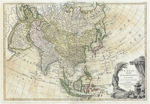
l'Asie divisee en ses Principaux Etats.
sold
- Digital Map Information
- Suitable for large format printing
- Full resolution TIFF file
- ICC color profile embedded
- Delivered instantly via download link
This is a beautiful example of Jean Janvier's 1762 map of Asia. It covers from Africa and the Mediterranean east to Bering Strait and south as far as Java and New Guinea. This map is most interesting in its rendering of the largely ... (more details)
Includes the Muller Peninsula in Alaska and the Sea of the West in North America.

l'Amerique divisee Par Grans Etats.
sold
- Digital Map Information
- Suitable for large format printing
- Full resolution TIFF file
- ICC color profile embedded
- Delivered instantly via download link
This is an altogether fascinating map of North America and South America by Jean Janvier dating to 1762. It covers both continents from the Antarctic Circle to the Arctic Circle, extends westward to New Zealand and eastward as far ... (more details)
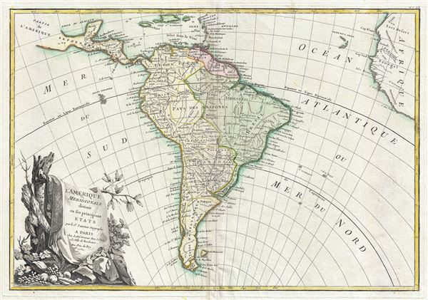
l'Amerique Meridionale divisee en ses principaux Etats.
sold
- Digital Map Information
- Suitable for large format printing
- Full resolution TIFF file
- ICC color profile embedded
- Delivered instantly via download link
This is a beautiful example of Jan Janvier's 1762 decorative map of South America. It covers from the island of Hispaniola and the Yucatan south to Tierra del Fuego and Cape Horn, east to Africa, and west to Mexico. The whole of ... (more details)

Carte Generale de la Pologne avec tous les Etats qui en dependent.
sold
- Digital Map Information
- Suitable for large format printing
- DPI: 300
- File Size: 10.32 MB
- File Type: ZIP / TIFF
- ICC color profile embedded
- Delivered instantly via download link
This is a beautiful example of Rizzi-Zannoni's 1762 decorative map of the Poland and its tributaries. It covers from Denmark and Germany eastward to Russia, northwards to Livonia and south to Hungary, including Lithuania, ... (more details)
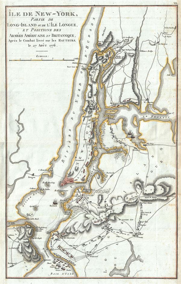
Ile de New York, Partie de Long-Island ou de I'le Longue, et Positions des Armees Americaine et Britannique, Apres le Combat livre sure Hauteurs le 27 Aout 1776.
sold
- Digital Map Information
- Suitable for large format printing
- Full resolution TIFF file
- ICC color profile embedded
- Delivered instantly via download link
This is a rare map of New York City during the American Revolutionary issued for the 1807 French edition of John Marshall's The Life of Washington . The map covers the strategically important Manhattan Island and ... (more details)

Partie de L'Etat de Rhode-Island et Position des Armees Americaine et Britannique, au Siege de Newport, et a l'affaire de 29 Aout 1778.
sold
- Digital Map Information
- Suitable for large format printing
- Full resolution TIFF file
- ICC color profile embedded
- Delivered instantly via download link
This is a rare map of Narragansett Bay, Rhode Island during the American Revolutionary War issued for the 1807 French edition of John Marshall's The Life of Washington . The map covers the strategically important ... (more details)

Shanghai.
sold
- Digital Map Information
- Suitable for large format printing
- File Size: 10.52 MB
- File Type: ZIP / TIFF
- ICC color profile embedded
- Delivered instantly via download link
A scarce pre-World War II map of Shanghai, China, issued by the Osaka Asahi Shimbun in 1937 or Showa 12, during the Battle of Shanghai (August 13, 1937). Centered on the riverfront Bund Distract, this map covers the heart of modern Shanghai including the International Settlement and French Concession. Larger scale regional maps appear in the upper left and lower right corners. (more details)
Scarce pocket map of London, edition not in Howgego.

Smith's New Plan of London, Westminster and Southwark: Comprehending All the New Buildings and 350 References to the Principal Streets with the New Docks at Wapping and Blackwell.
sold
- Digital Map Information
- Suitable for large format printing
- DPI: 300
- File Size: 21.65 MB
- File Type: ZIP / TIFF
- ICC color profile embedded
- Delivered instantly via download link
A scarce 1822 dissected pocket map of London, England, by Charles Smith. Centered on the Thames River, this map covers from Paddington to Greenwich and from Chelsea Common to Stratford. The City of London is ... (more details)
Includes the Muller Peninsula in Alaska, an enlarged Australia, and the Sea of the West in North America.

Mappe-Monde ou Description du Globe Terrestre, Assujettie aux Observations Astronomiques.
sold
- Digital Map Information
- Suitable for large format printing
- Full resolution TIFF file
- ICC color profile embedded
- Delivered instantly via download link
A beautiful and impressive map of the world drawn by Jean Janvier in 1762. Depicts the entire world on a double hemisphere projection framed by elaborate baroque cartouchework. North America, particularly the ... (more details)
A remarkable Pre-Cook polar projection showing the Arctic and the Sea of the West.
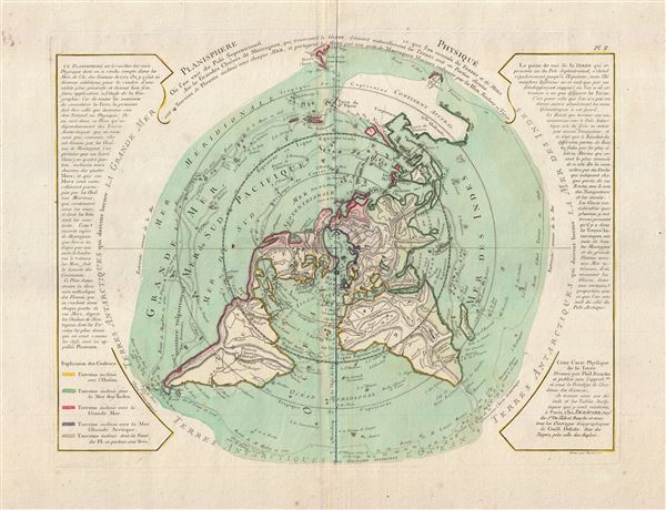
Planisphere Physique.
sold
- Digital Map Information
- Suitable for large format printing
- DPI: 300
- File Size: 12.32 MB
- File Type: ZIP / TIFF
- ICC color profile embedded
- Delivered instantly via download link
An exceptionally bright and beautiful c. 1781 Philippe Buache map of the world presented on an unusual polar projection rendered from the North Pole. The map covers from the North Pole Arctic region south ... (more details)
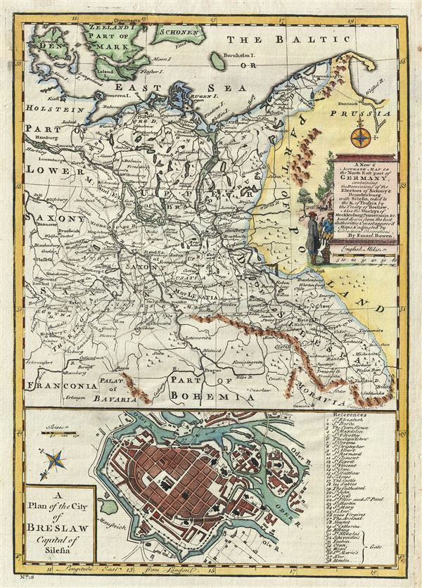
A New & Accurate Map of the North East part of Germany, containing the Dominions of the Electors of Saxony and Brandenburg with Silesia, ceded to the K. of Prussia by the Treaty of Breslaw. Also the Duchys of Mecklenburg, Pomerania etc.
sold
- Digital Map Information
- Suitable for large format printing
- DPI: 300
- File Size: 5.18 MB
- File Type: ZIP / TIFF
- ICC color profile embedded
- Delivered instantly via download link
This is a beautiful 1747 map of the northeastern part of Germany by the British cartographer Emanuel Bowen. It includes the Electors of Saxony and Brandenburg and the duchy of Mecklenburg, Pomerania and ... (more details)

A New & Accurate Map of the South East part of Germany, containing the Electorate of Bavaria, A.Bp. of Saltzburg, K. of Bohemia, with the Queen of Hungary's Hereditary Dominions of Austria, Moravia, Styria, Carinthia, Carniola, Trent, Tirol. etc.
sold
- Digital Map Information
- Suitable for large format printing
- DPI: 300
- File Size: 5.01 MB
- File Type: ZIP / TIFF
- ICC color profile embedded
- Delivered instantly via download link
This is a beautiful 1747 map of the southeastern part of Germany and the Czech Republic by the British cartographer Emanuel Bowen. It includes the Kingdom of Bohemia (modern day Czech Republic), the ... (more details)
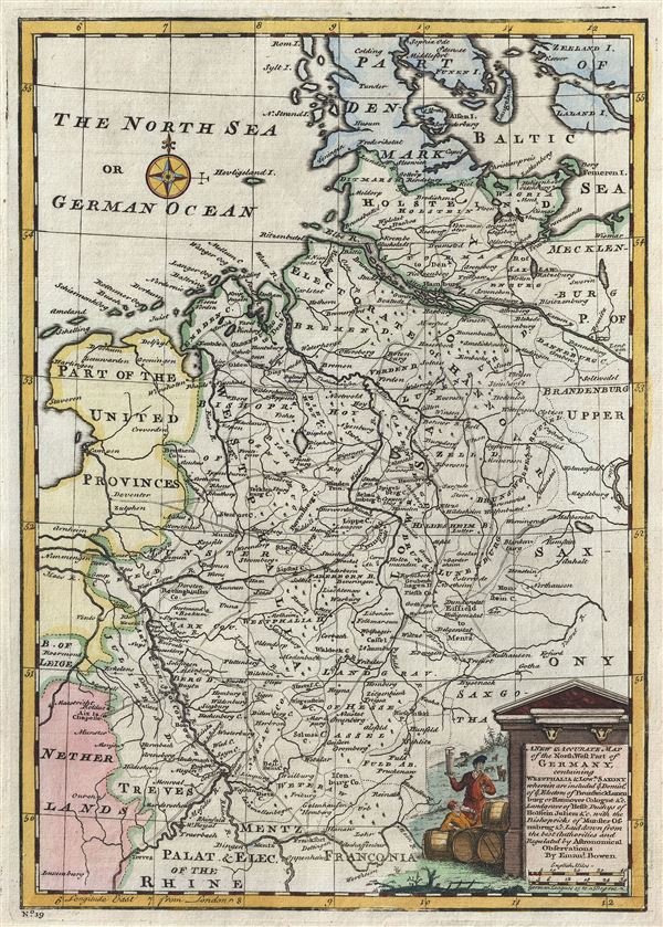
A New and Accurate Map of the Northwest part of Germany, containing Westphalia and Lowr. Saxony, wherein are included ye. domins. of ye. Electors of Brunswick Lunenburg or Hannover Cologne etc., Landgrave of Hesse, Duchys of Holstein, Juliers etc., with the Bishopricks of Munster, Osnabrug etc.
sold
- Digital Map Information
- Suitable for large format printing
- DPI: 300
- File Size: 4.84 MB
- File Type: ZIP / TIFF
- ICC color profile embedded
- Delivered instantly via download link
This is an appealing 1747 map of the northwestern part of Germany by the British Cartographer Emanuel Bowen. It covers the Westphalia and Lower Saxony regions of Germany from Denmark south as far as ... (more details)

Shanghai From an Original Sketch. Bridge across the Cauvery, at Trichinopoly.
sold
- Digital Map Information
- Suitable for large format printing
- Full resolution TIFF file
- ICC color profile embedded
- Delivered instantly via download link
A pleasing view of Shanghai, China from the September 18, 1854 issue of The Illustrated London News. This view of Shanghai at the bottom of the page is drawn from an original sketch and depicts the ... (more details)
Identifies the Sea of Korea.
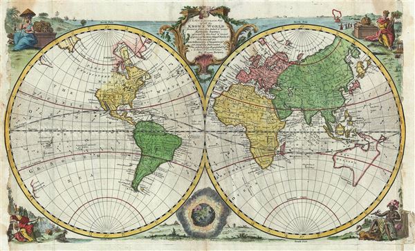
A New and Accurate Map of all the Known World.
sold
- Digital Map Information
- Suitable for large format printing
- DPI: 300
- File Size: 11.66 MB
- File Type: ZIP / TIFF
- ICC color profile embedded
- Delivered instantly via download link
This is an extremely attractive 1747 decorative double hemisphere world map by the English cartographer Emmanuel Bowen. This beautiful map covers the entire world as it was understood in the middle ... (more details)