
Before the Texas Revolution, the Mexican American War, and the Trail of Tears.
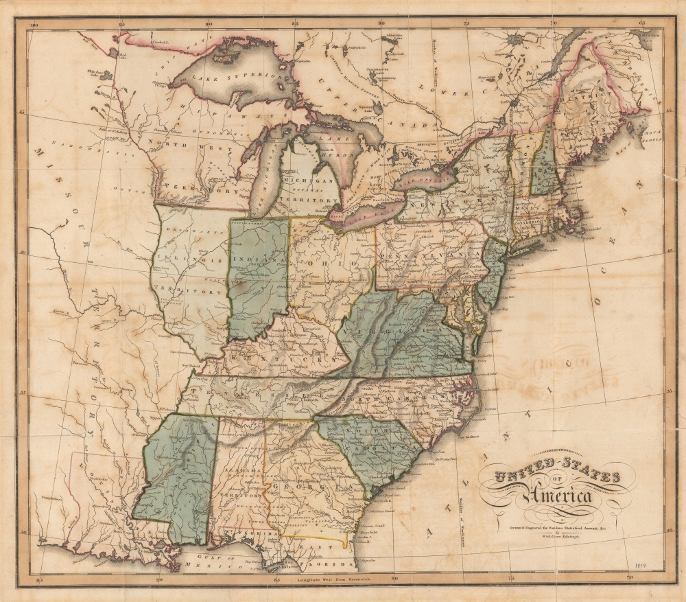
United States of America.
$850.00
Acquire
- Digital Map Information
- Suitable for large format printing
- DPI: 600
- File Size: 31.95 MB
- File Type: ZIP / TIFF
- ICC color profile embedded
- Delivered instantly via download link
A rare 1819 map of the United States issued by William Lizars for David Baillie Warden's Statistical, Political, and Historical Account of the United States of America. The map illustrates the early days of the westward expansion prior to the Texas Revolution, the Mexican-American War, and the Trail of Tears. (more details)
Ortelius, himself.

[Untitled Portrait].
sold
- Digital Map Information
- Suitable for large format printing
- Full resolution TIFF file
- ICC color profile embedded
- Delivered instantly via download link
This is Philip Galle's portrait of Abraham Ortelius, first appearing in the 1579 edition of Ortelius' Theatrum Orbis Terrarum, Galle's engraving is after a portrait by Flemish painter Adriaen Thomasz Key (1544 - 1589), one of Antwerp's most prolific and successful portrait painters, and a guild-member with Ortelius. Key is known for his precise, almost photorealistic portraits making Galle's engraving the most accurate representation of the pioneering mapmaker available to the collector.
The portrait, in left profile, is presented in an elaborately garlanded strapwork frame. At the top is Ortelius' personal symbol: the Chi-Rho, flanked with Alpha and Omega - a Christogram - and the motto 'Vitae Scopus' (The goal of life). At the base of the portrait is an elegiac couplet composed by Andreas de Pape (1542 - 1581), a poet and musician, and also one of Galle's editors. His Latin couplet translates as: Ortelius gave mortals the world to look at, and Galle gave the world Ortelius to look at. (more details)
The portrait, in left profile, is presented in an elaborately garlanded strapwork frame. At the top is Ortelius' personal symbol: the Chi-Rho, flanked with Alpha and Omega - a Christogram - and the motto 'Vitae Scopus' (The goal of life). At the base of the portrait is an elegiac couplet composed by Andreas de Pape (1542 - 1581), a poet and musician, and also one of Galle's editors. His Latin couplet translates as: Ortelius gave mortals the world to look at, and Galle gave the world Ortelius to look at. (more details)
Best colonial map of Virginia and Maryland.
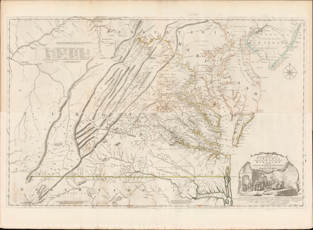
A Map of the most Inhabited part of Virginia containing the whole Province of Maryland with Part of Pensilvania, New Jersey and North Carolina drawn by Joshua Fry and Peter Jefferson in 1775.
sold
- Digital Map Information
- Suitable for large format printing
- Full resolution TIFF file
- ICC color profile embedded
- Delivered instantly via download link
This is the monumental 1775 Fry/Jefferson map of Virginia and Maryland, the most important colonial map of Virginia, in its original four-sheet English version. Drawn by Joshua Fry and Peter Jefferson in 1751 and first printed in 1753, this was the first accurate survey of the interior of Virginia. It was the first printed map to approximate the parallel ridges and valleys of the Appalachian Mountains, and the first to accurately depict the Blue Ridge Mountains. Following the revision of the map in 1755, this was the first map to include Virginia's road system, also marking routes used by frontier traders and Native Americans. Following that revision, it contained the best mapping of the Upper Ohio Valley and the Virginia frontier produced during the French and Indian War (1754 - 1763) and remained the prototype for all subsequent maps of Virginia until the 19th century. As both Fry and Jefferson were denizens of the colony, this further represents the first map of Virginia produced by Virginians. (more details)
Formative Years of Corlears Hook.

[Quackenboss at Corlear's Hook.]
sold
- Digital Map Information
- Suitable for large format printing
- DPI: 600
- File Size: 35.91 MB
- File Type: ZIP / TIFF
- ICC color profile embedded
- Delivered instantly via download link
This is a late 18th century manuscript real estate survey of the Corlears Hook neighborhood of New York City. Its content and comparison with other extant manuscripts strongly suggest a date between 1785 and 1788. The survey reveals patterns of land ownership in the area just prior to the explosion of development that would transform Corlears Hook from pastoral farmland into a notorious tenderloin, while simultaneously preserving evidence of the manors that characterized this part of New York in the eighteenth century. (more details)
Behind the lines in a Civil War battle.

Battle of Weldon Rail-Road. August 21st, 1864.
sold
- Digital Map Information
- Suitable for large format printing
- File Size: 70.18 MB
- File Type: ZIP / TIFF
- ICC color profile embedded
- Delivered instantly via download link
This is a c. 1864 Richard Holland view of the American Civil War Battle of Weldon Railroad. The view is distinctive among Civil War prints for providing a rarely-seen view of events behind the lines of battle. Part of the Petersburg Campaign, the Battle of Weldon Railroad resulted in Union forces successfully severing the last railroad linking Petersburg and Richmond with Wilmington, North Carolina, the Confederacy's last remaining Atlantic port. (more details)
Extraordinary panorama illustrating the route of the Mormon pioneers and the westward expansion.
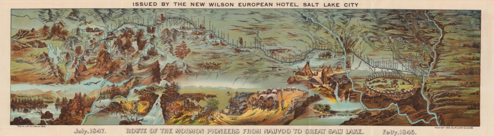
Route of the Mormon Pioneers from Nauvoo to Great Salt Lake.
sold
- Digital Map Information
- Suitable for large format printing
- Full resolution TIFF file
- ICC color profile embedded
- Delivered instantly via download link
This is a beautiful 1899 chromolithograph panoramic bird-eye view map of the 1,300-mile Mormon Trail. It is one of the finest illustrations of the Mormon migration ever published. (more details)
Longing for what was loss in the Great War.

An Anciente Mappe of Fairy Land newly discovered and set forth.
sold
- Digital Map Information
- Suitable for large format printing
- Full resolution TIFF file
- ICC color profile embedded
- Delivered instantly via download link
An unusual discovery. This is a period magazine promotion of Bernard Sleigh's fantastical 1921 map of Fairyland - one of the great masterpieces of fantasy cartography. Bernard Sleigh produced the original to wide acclaim in the aftermath of World War I (1914 - 1918). The present double page presentation, issued by The World magazine, offers a teaser glimpse of the right side of Sleigh's 6-foot-long masterpiece, as well as fascinating content offering unique insights into the map's publication. (more details)
Global geography for the Japanese public.

萬國地誌畧諳射譯圖四 / [Translated Topographical Maps of the World, 4].
sold
- Digital Map Information
- Suitable for large format printing
- File Size: 10.72 MB
- File Type: ZIP / TIFF
- ICC color profile embedded
- Delivered instantly via download link
A colorful 1878 (Meiji 11) Japanese map of North America by Yamada Shintarō and Takahara Tetsuya. It reflects the distribution of geographic knowledge from abroad in the early Meiji period, and more specifically the development of popular geographical knowledge. (more details)
Cuban propaganda decrying American violence in Vietnam.

La Paz de Nixon. La Paix de Nixon. Nixon's Peace.
sold
This is a 1972 Lázaro Abreu Patrón and Organization of Solidarity of the Peoples of Asia, Africa and Latin America Vietnam War propaganda map of Southeast Asia decrying 'Nixon's Peace'. This likely refers to the Nixon administration launching Operation Linebacker II, a massive bombing campaign against North Vietnam in December 1972, as a way to force the North Vietnamese to remain at the negotiating table. (more details)
This WWII unit built bridges, operated hospitals, and delivered supplies.

ADSEC in Action from Thames to Rhine.
sold
This is a 1945 John Ciofalo and Clifford Helstrom World War II pictorial map of ADSEC (Advance Section of the Communications Zone), the forward supply unit of the American army. This unit built bridges, operated hospitals, evacuated wounded, and delivered supplies. (more details)
A Soviet H-Bomb.

EVACUATE. Don't Sit Under the Mushroom. Civil Defense Evacuation Routes King County, Washington.
sold
This is a 1955 Seattle and King County Civil Defense nuclear evacuation map of Seattle, Washington. Published the same year as the first Soviet fusion (thermonuclear) bomb test, this piece underscores American fears of nuclear annihilation from coast to coast. (more details)
Libraries for soldiers.

Library War Service of the American Library Association. United War Work Campaign - Week of November 11, 1918.
sold
- Digital Map Information
- Suitable for large format printing
- File Size: 50.6 MB
- File Type: ZIP / TIFF
- ICC color profile embedded
- Delivered instantly via download link
This is a 1918 American Library Association (ALA) map of the United States highlighting 'Special War Libraries' created by the ALA during World War I. Published during the week of the Armistice (November 11, 1918), squares mark military camps that have dedicated library buildings, while circles mark camps that have libraries in other buildings. Statistics along the bottom border detail the number of camp library buildings in operation at the time of publication, librarians employed by the Service, Library War Service distribution points overseas, and the number of books shipped overseas, among many other facts. (more details)
Selling Sanford.

Sanford, Florida / Seminole County, Florida.
sold
- Digital Map Information
- Suitable for large format printing
- Full resolution TIFF file
- ICC color profile embedded
- Delivered instantly via download link
A detailed c. 1942 pair of maps of Sanford, Florida and Seminole County, of which Sanford is the seat. Along with the accompanying promotional materials, they reflect the successful efforts of local 'boosters,' including the Chamber of Commerce, to promote the area to tourists and migrants. (more details)
All roads lead to Reno.

Alaska to Mexico via Reno - 'Fun Center of the West.'
sold
A 1961 strip road map by Gerald Eddy, produced for the Harolds Club casino in Reno, Nevada. Between the recto and verso, the entire route from Nome, Alaska to the Mexico-Guatemala border is charted, with primacy of place given to Reno and Harolds Club specifically. (more details)
The only indigenous Siamese map outside of Siam.

[Siam, Cambodia.]
sold
- Digital Map Information
- Suitable for large format printing
- Full resolution TIFF file
- ICC color profile embedded
- Delivered instantly via download link
Two c. 1800 Siamese / Thai manuscript maps, drawn back-to-back on hand loomed cotton. The significance of these maps cannot be understated. They are likely working drafts for parts of a series of maps compiled for and presented to the Siamese kings sometime between 1783 and 1825. Collectively, they represent the only examples of indigenous Siamese non-religious cartographic visualization outside 17 Royal Maps (really just 11, see below). As working draft, these maps may predate the Royal Siamese Maps, possibly making them the earliest known Thai maps. (more details)
Realities in conflict.
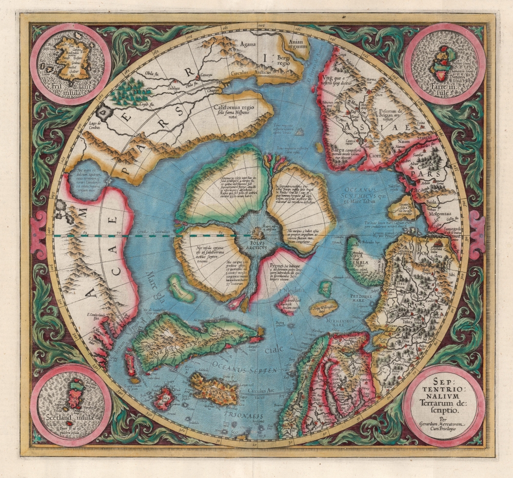
Septentrionalium Terrarum descriptio.
sold
- Digital Map Information
- Suitable for large format printing
- Full resolution TIFF file
- ICC color profile embedded
- Delivered instantly via download link
This is the second state of Gerard Mercator's 1606 map of the North Pole or Arctic, one of the great cartographer's most interesting and important maps. This map marks a significant step forward in the cartographic understanding of the high Arctic, more importantly, is a groundbreaking transition between mediaeval and modern cosmographical perspectives. (more details)
One of the earliest obtainable maps of Singapore.
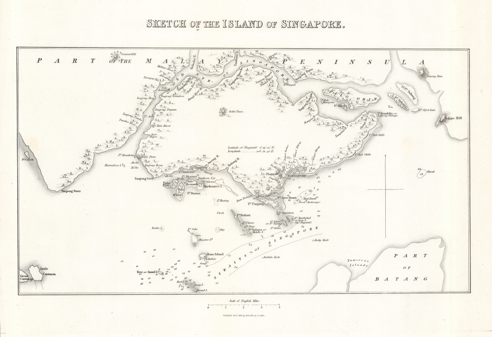
Sketch of the Island of Singapore.
sold
- Digital Map Information
- Suitable for large format printing
- DPI: 600
- File Size: 8.36 MB
- File Type: ZIP / TIFF
- ICC color profile embedded
- Delivered instantly via download link
A scarce, early map and chart of Singapore, published by John Murray in 1830 for Lady Sophia Raffles' Memoir of the life and public services of Sir Thomas Stamford Raffles, four years after her husband's death. It depicts the nascent colonial city in the early years after the development of the Raffles Town Plan, a partially-realized scheme for the city's future development. (more details)
'A towering landmark along the path of Western cartographic development' - Wheat
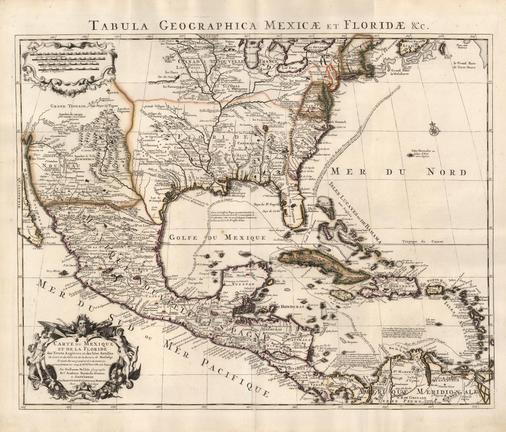
Carte du Mexique et de la Floride des Terres Angloises et des Isles Antilles... / Tabula Geographica Mexicae et Floridae etc.
sold
- Digital Map Information
- Suitable for large format printing
- Full resolution TIFF file
- ICC color profile embedded
- Delivered instantly via download link
This is the 1722 Covens and Mortier issue of Guillaume de L'Isle's groundbreaking map of North America, focusing on Mexico, the Mississippi watershed, and the West Indies. De L'Isle first published this map in 1703, at which point it was the most sophisticated map of the region obtainable: the first map to accurately denote the course of the Mississippi River, the first to accurately place the Great Lakes, and the first appearance on a map of updates from La Salle, Bienville, and D'Iberville. (more details)
Crédit Lyonnais in North and West Africa.
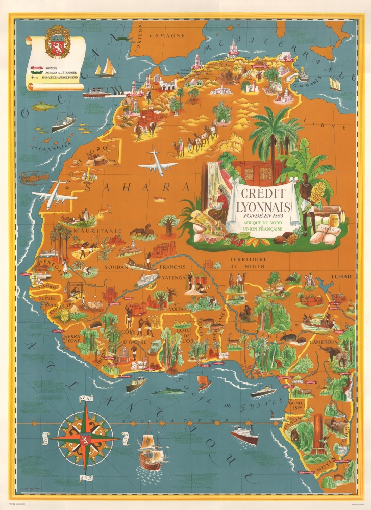
Crédit Lyonnais. Fondé en 1863. Afrique du Nord et Union Française.
sold
This is a c. 1956 Lucien Boucher art deco pictorial map of the Maghreb and West Africa highlighting Crédit Lyonnais banks. The map reflects the work of one of the greatest pictorial map makers of the mid-20th century. Moreover, it illustrates French Africa at the beginning of its decline as a political power. (more details)
Peopling the Peninsula.
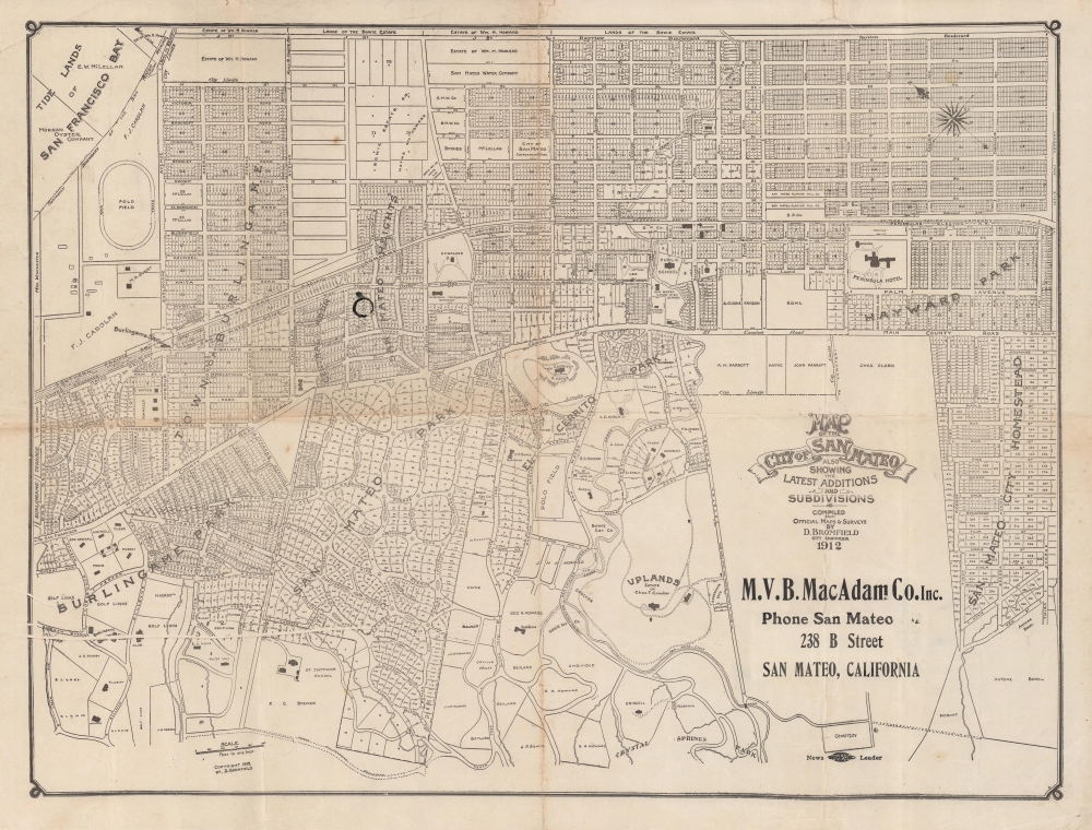
Map of the City of San Mateo showing the latest additions and subdivisions.
sold
- Digital Map Information
- Suitable for large format printing
- File Size: 12.3 MB
- File Type: ZIP / TIFF
- ICC color profile embedded
- Delivered instantly via download link
A rare 1912 map of San Mateo, California by City Engineer Davenport Bromfield. It displays the city on the heels of rapid growth (the population more than doubled between 1900 and 1910), as it and surrounding communities transitioned from farming to a suburban retreat for the elite of San Francisco. (more details)