
The largest Union prisoner of war camp during the Civil War.

Point Lookout, Md. View of Hammond General Hospital and U.S. Genl. Depot for Prisoners of War.
sold
- Digital Map Information
- Suitable for large format printing
- File Size: 150.63 MB
- File Type: ZIP / TIFF
- ICC color profile embedded
- Delivered instantly via download link
This is an 1864 George Everett chromolithograph bird's-eye view of Point Lookout, Maryland, at the height of the American Civil War (1861 - 1865). Point Lookout was home to the Hammond General Hospital (illustrated here in the foreground) and a notorious Prisoner of War camp. (more details)
Chinese slavery in Cuba.

Compania Asiatica de la Habana.
sold
- Digital Map Information
- Suitable for large format printing
- Full resolution TIFF file
- ICC color profile embedded
- Delivered instantly via download link
Highlighting a little-known episode in history, this is a rare 1858 broadside contract between the Compañia Asiatica de la Habana, and a Chinese laborer arranging for his importation to Cuba to work as an indentured servant on a sugar plantation. This document provides an incomparable record of the Chinese experience in Cuba. An illustration at top center shows a ship and a Chinese laborer working next to a Cuban farmer. (more details)
Gold and silver.

Map of the Colorado Territory to accompany Hollister's 'Mines of Colorado' corrected from the Public Surveys of 1866.
sold
- Digital Map Information
- Suitable for large format printing
- File Size: 51.64 MB
- File Type: ZIP / TIFF
- ICC color profile embedded
- Delivered instantly via download link
This is an 1867 Major and Knapp map of the Colorado Territory. Gold, silver, and coal deposits are marked throughout with the 'developed gold region' identified. The territorial capital was then at Golden City. (more details)
Japan exerts control over Taiwan.

臺灣實測明細全圖 / [Complete Detailed Survey Map of Taiwan].
sold
- Digital Map Information
- Suitable for large format printing
- File Size: 16.03 MB
- File Type: ZIP / TIFF
- ICC color profile embedded
- Delivered instantly via download link
A scarce 1895 map of Taiwan by Kurashima Izaemon. It was produced during Japan's military conquest and occupation of the island in the closing stage of the First Sino-Japanese War (1894 - 1895), which began a fifty-year period of colonization. (more details)
Cape Cod - its history and culture.

A Map of Interesting Cape Cod.
sold
- Digital Map Information
- Suitable for large format printing
- File Size: 56.32 MB
- File Type: ZIP / TIFF
- ICC color profile embedded
- Delivered instantly via download link
This is a c. 1950 F. J. Miller pictorial map of Cape Cod, including Nantucket and Martha's Vineyard. The map celebrates Cape Cod, its history of seamanship, and the restful qualities of beachfront life: artists painting picturesque scenery, bucolic coastal scenes, and gentlemanly sporting life. (more details)
Earliest Lithograph of the Singapore Strait.

Presqu'ile de Malacca. Oceanique no. 12.
sold
- Digital Map Information
- Suitable for large format printing
- DPI: 600
- File Size: 21.51 MB
- File Type: ZIP / TIFF
- ICC color profile embedded
- Delivered instantly via download link
This is the 1827 Vandermaelen map of Singapore and the Malay Peninsula. It is the first large-scale atlas map to focus on the area, and the first to be executed in lithography. The map shows Singapore Island, Bintan, Kepulauan Anambas, Kepulauan Natuna Besar, and part of Sumatra. The interior details of Malacca - particularly the attractively hachured mountains appearing on the Malay Peninsula - reveal that despite the presence for nearly eight years of an English colony on Singapore, European knowledge of this part of the world remained scant. In all fairness, this ignorance cannot be laid entirely at Vandermaelen's feet: the Jackson plan itself would not be published for still another year, in 1828, and it was the first map to show the colony. (more details)
One of the first detailed maps of the Taiwan / Formosa interior.
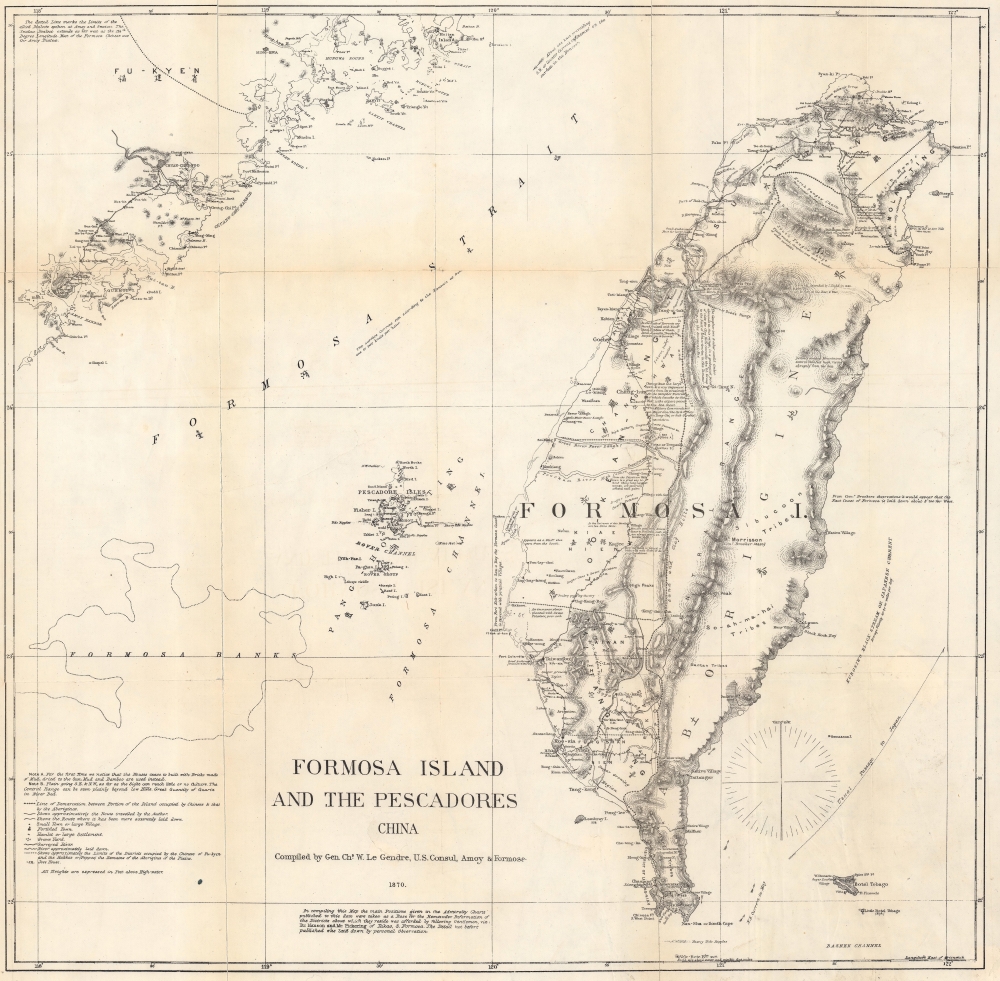
Formosa Island and the Pescadores China.
sold
- Digital Map Information
- Suitable for large format printing
- File Size: 40.43 MB
- File Type: ZIP / TIFF
- ICC color profile embedded
- Delivered instantly via download link
An interesting, important, and uncommon map of Taiwan or Formosa issued in 1870 by the American Consul at Amoy, Charles W. Le Gendre. This map represents the only detailed survey of Taiwan's interior prior to the Japanese invasion. It was issued in the wake of the tragic Rover Incident (see below), but more accurately reflects American interest in Formosa as a naval supply hub in the China Sea. It formed the basis of most subsequent maps of Taiwan's interior until the Japanese surveys of the 1890s. (more details)
National self-determination! (But only for Europeans.)
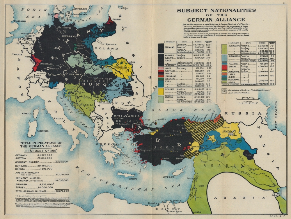
Subject Nationalities of the German Alliance.
sold
- Digital Map Information
- Suitable for large format printing
- Full resolution TIFF file
- ICC color profile embedded
- Delivered instantly via download link
This is a 1917 Cassell propaganda map of Europe promoting national and ethnic self-determination. (more details)
Explore the Canadian Rocky Mountains with the help of the Canadian Pacific Railway.
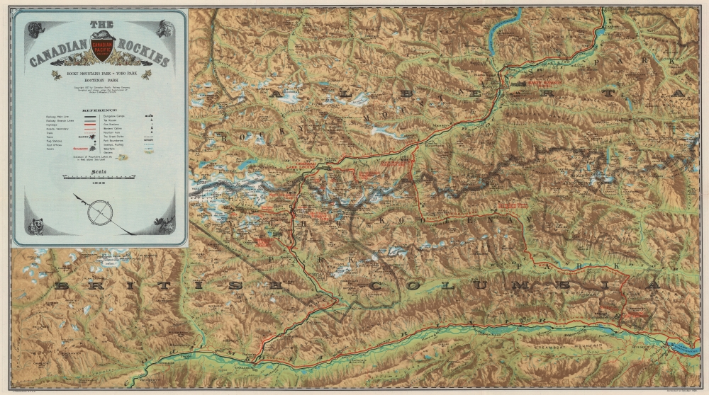
The Canadian Rockies: Rocky Mountain Park - Yoho Park - Kootenay Park.
sold
- Digital Map Information
- Suitable for large format printing
- Full resolution TIFF file
- ICC color profile embedded
- Delivered instantly via download link
This is a 1928 Canadian Pacific Railway pictorial map of the Canadian Rocky Mountains in Alberta and British Columbia created to cultivate outdoor adventure tourism. (more details)
Travel India!

India. Seeing India Made Easy Through this Road, Rail, Sea, and Air Route Map Guide.
sold
This is a c. 1960 Tej Brothers tourist road map of India. (more details)
Following a Wehrmacht division through the Fall of France.
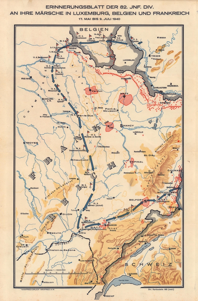
Erinnerungsblatt der 82. Jnf. Div. An Ihre Märsche in Luxemburg, Belgien, und Frankreich 17. Mai bis 9. Juli 1940.
sold
- Digital Map Information
- Suitable for large format printing
- File Size: 24.03 MB
- File Type: ZIP / TIFF
- ICC color profile embedded
- Delivered instantly via download link
This is a c. 1940 Div. Kartenstelle route map of the Wehrmacht 82nd Infantry Division in Eastern France during World War II (1939 - 1945). While route maps following American and British units during World War II are prevalent, their German counterparts are exceedingly rare. (more details)
Cincinnati, including the subway that never was.

Mendenhall's standard guide map of Cincinnati : accompanied by new ready reference street index.
sold
- Digital Map Information
- Suitable for large format printing
- Full resolution TIFF file
- ICC color profile embedded
- Delivered instantly via download link
A large-scale folding map of Cincinnati and its suburbs produced in 1928 by C.S. Mendenhall. It depicts the city as it grew considerably, annexing nearby towns and filling in surrounding countryside. (more details)
The emergence of the East Bay.

Map of Oakland, Berkeley, Piedmont, Alameda, Emeryville, San Leandro, Albany : [prepared for] Henry Z. Jones, Jr. Realtor.
sold
- Digital Map Information
- Suitable for large format printing
- Full resolution TIFF file
- ICC color profile embedded
- Delivered instantly via download link
A rare c. 1933 map of Oakland, Berkeley, and other East Bay cities issued by realtor Henry Z. Jones. It highlights the development of Oakland and the East Bay as an urban hub in the early 20th century. (more details)
New nations emerge.
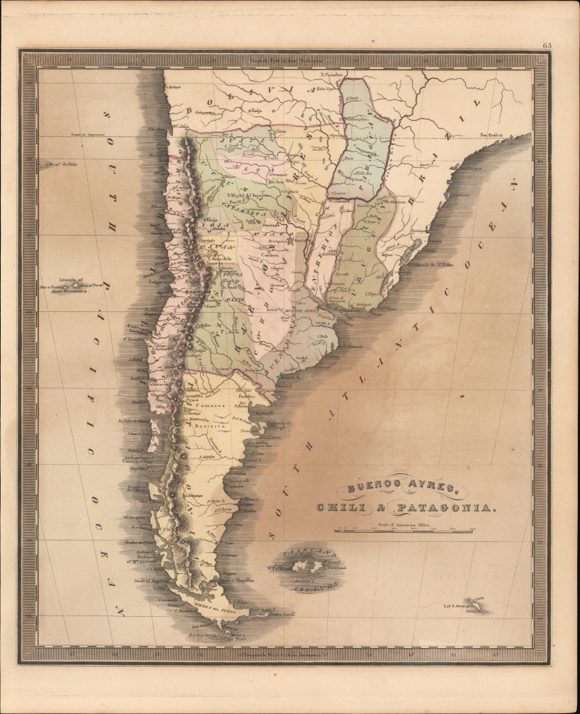
Buenos Ayres, Chili and Patagonia.
sold
- Digital Map Information
- Suitable for large format printing
- DPI: 600
- File Size: 19.84 MB
- File Type: ZIP / TIFF
- ICC color profile embedded
- Delivered instantly via download link
This is Jeremiah Greenleaf's 1849 map of Argentina, Chile, Uruguay, and Paraguay. (more details)
Rare bird's-eye view of Norwich, Connecticut early in the Industrial Revolution.

City of Norwich Conn. 1876.
sold
- Digital Map Information
- Suitable for large format printing
- File Size: 135.7 MB
- File Type: ZIP / TIFF
- ICC color profile embedded
- Delivered instantly via download link
This is a rare 1876 chromolithograph bird's-eye view of Norwich, Connecticut, by Oakley Hoopes Bailey. Centered on the conjunctions of the Yantic, Shetucket, and Thames Rivers, the view looks northwards towards Norwich from a fictive high point just to the south. It illustrates Norwich early in the industrial revolution, with paddlewheel steamships competing for space on the river with sailing ships. Holly Hock Island is here a place of industry, with large factories billowing black smoke. Forested bucolic hills fade off into the horizon. (more details)
French voyages of discovery from the 15th through the 19th century.
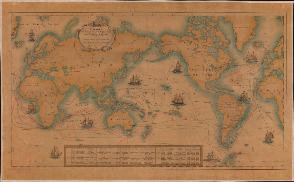
Voyages des Découvertes et d'Explorations des Marins Français depuis le XVe. siècle.
sold
- Digital Map Information
- Suitable for large format printing
- File Size: 197.55 MB
- File Type: ZIP / TIFF
- ICC color profile embedded
- Delivered instantly via download link
This is a 1930 L. Bergelin pictorial map of the world celebrating French voyages of discovery from 1402 to 1840. This map appeared at the end of the Années folles, a post-World War I period of rich social, artistic, and cultural innovation centered in Paris. It coincided with a resurgence of French national pride, much of which was expressed in novel new forms of art that combined advances in printing, the rise of propaganda imagery, and egalitarian social values. (more details)
Steamships in Asia.

Java-China Japan Lyn. / Map Showing Routes Ports of Call and services of the java-China Japan Line.
sold
- Digital Map Information
- Suitable for large format printing
- File Size: 178.73 MB
- File Type: ZIP / TIFF
- ICC color profile embedded
- Delivered instantly via download link
A dramatic large-scale c. 1930 Edward Stanford map promoting the Java-China Japan (JCJL) steamship line. Coverage extends from Mongolia to Java and northern Australia and from Burma to New Guinea, embracing China, Japan, Taiwan, Southeast Asia, the East Indies, and the Philippines. Blue lines trace the routes of the JCJL through the Yellow, China, and Java Seas. (more details)
North America - the Known World.

Known World of the Society for Creative Anachronism.
sold
A remarkable c. 1982 Merald Clark map of the 'Known World' of the Society of Creative Anachronism (SCA). The map adopts a European medieval ethos but is analogous to North America, oriented to the west. The Known World here predates the founding of most international SCA chapters and is thus limited to North America. 'Kingdoms' represent regional Society chapters - for example, Anestorra encapsulates the Texas chapter - with individual cities representing more local groups - Austin is, for example, Bryn Gwlad. (more details)
An attractive small-format map of India and the Spice Islands.

India Orientalis.
sold
- Digital Map Information
- Suitable for large format printing
- DPI: 600
- File Size: 7.01 MB
- File Type: ZIP / TIFF
- ICC color profile embedded
- Delivered instantly via download link
This is Giovanni Magini's 1596 map of the East Indies. It presents what, prior to the explosion of the Dutch into the spice trade, was the state of the art of the European mapping of the East. (more details)
Speculative cartography and urban development in Queens.
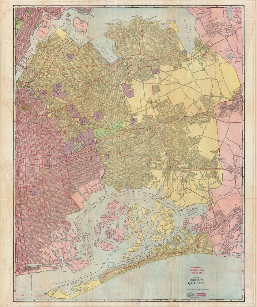
Map of Borough of Queens / Map of Nassau and Suffolk Counties / Map of Boroughs of Manhattan and Bronx.
sold
- Digital Map Information
- Suitable for large format printing
- Full resolution TIFF file
- ICC color profile embedded
- Delivered instantly via download link
A rare, highly-detailed, and curious 1913 map of the Borough of Queens, with maps of Manhattan, the Bronx, and Long Island on the verso. The map reveals Queens during its most explosive period of growth - as such, it is highly speculative, despite a misleading level of seemingly precise detail based upon prospective (but often unrealized) development schemes. (more details)