
Richard Rummell's gorgeous view of Penn State including the original Old Main and Old Engineering.

The Pennsylvania State College.
sold
- Digital Map Information
- Suitable for large format printing
- File Size: 34.25 MB
- File Type: ZIP / TIFF
- ICC color profile embedded
- Delivered instantly via download link
This is a 1910 Richard Rummell view of The Pennsylvania State University, popularly known as Penn State. Illustrating what was then the Pennsylvania State College from the southeast, Allen Street Mall bisects the view and, it should be noted, was still open to traffic at the time. The original Old Main is instantly recognizable just to the right of The Mall overlooking Old Main Lawn. Built in 1863, the original Old Main contained classrooms, laboratories, offices, a chapel, and rooms for 400 students. The building was deemed structurally unsound in the 1920s and razed in 1929. It was rebuilt in 1930, and the Old Main building that stands on campus today occupies the same piece of real estate where the original Old Main stood. Schwab Auditiorium is illustrated just behind and to the left of Old Main. Across The Mall from Old Main stands the Armory, which was originally constructed in 1892. This building housed the physical education facilities, as well as places for varsity athletics and other social events. It also served as the base of operations for the college's Cadet Corps, which was required of all male students until World War I. The Carnegie Building, built in 1904, stands behind the Armory and is currently occupied by Penn State's College of Communication and the Daily Collegian. Other buildings that still stand on campus today that are illustrated here include Old Botany, Ihlseng Cottage, and the McAllister Building. The large building in the foreground just to the left of center is Old Engineering, constructed in 1893 for the college's new engineering program. Unfortunately, the building caught fire and burned down in 1918 and Sackett Hall now stands in its place. (more details)
Provides statistics as to how badly the United States is losing the war in Vietnam.

越南人民抗美救国形势图. / [Vietnamese people's anti-US and national saving situation map.]
sold
- Digital Map Information
- Suitable for large format printing
- File Size: 8.12 MB
- File Type: ZIP / TIFF
- ICC color profile embedded
- Delivered instantly via download link
This is a c. 1967 Chinese anti-American propaganda broadside created by Zhu Yu Lian. The map depicts the region from Laos and Cambodia to the South China Sea and from China to the Cà Mau Peninsula. Both North and South Vietnam are illustrated, with North Vietnam ... (more details)
A French broadside advertising an illustrated history of the 1900 Paris Universal Exposition.

L'Exposition de Paris de 1900 Splendide publication de grand format et illustrée avec luxe.
sold
- Digital Map Information
- Suitable for large format printing
- File Size: 84.11 MB
- File Type: ZIP / TIFF
- ICC color profile embedded
- Delivered instantly via download link
This is a c. 1900 Montgredien promotional broadside of the 1900 Paris Universal Exposition. The broadside, advertising the special-edition book L'Exposition de Paris de 1900, which was published by Montgredien in several volumes in 1900 features portraits of the most important individuals involved in creating the Exposition, a map of the Exposition grounds, and several views of the construction of some of the attractions. The map of the Exposition grounds is situated just above the center of the broadside and identifies the many pavilions and other installations attendees can visit. Some of the buildings erected for the Exposition Universelle will be familiar to modern-day visitors to the City of Light, and these include the Grand Palais, the Petit Palais, and the Pont Alexandre III. The Exposition grounds stretch from the Place de la Concorde to the Place du Trocadero on along the Seine's Right Bank, and, along the Left Bank, from the Eiffel Tower and the Champs de Mars to the Pont Alexandre III and the Esplanade des Invalides. Pavilions on the Champs de Mars are dedicated to fields of interest, such as agriculture, chemistry, education and teaching, and mines and metallurgy. The foreign pavilions line the Left Bank, while the celebrated exhibit 'Le Vieux Paris' is situated on the Right Bank, between the Trocadero and the Grand Palais.
Below the map, a view of the 'Le Vieux Paris' exhibit gives the viewer of what they will encounter: a full-scale rebuilding of Paris's history in the form of buildings from the Midde Ages until the Revolution. People in period costumes will be present and presumably interacted with visitors. Surrounding the central map and view of 'Le Vieux Paris' are portraits of the exhibition's architects and organizers and engravings of parts of the building process. Two large portraits are situated in the two top corners. The one on the left is Joseph-Antoine Bouvard, the Director of Architecture for the entire Exposition Universelle, while Alfred Picard, the General Commissioner of the Exposition, occupies the right corner. Along the left side is a portrait of Alfred Robida, the architect of 'Le Vieux Paris', and other portraits portray the architects of the Grand Palais and the Pont Alexandre III, among other buildings. The views illustrate, among other things, the celebrated electric walkway (which was much like today's moving sidewalks used in airports and other places), the construction of the Petit Palais, and the construction of the Pont Alexandre III. (more details)
Below the map, a view of the 'Le Vieux Paris' exhibit gives the viewer of what they will encounter: a full-scale rebuilding of Paris's history in the form of buildings from the Midde Ages until the Revolution. People in period costumes will be present and presumably interacted with visitors. Surrounding the central map and view of 'Le Vieux Paris' are portraits of the exhibition's architects and organizers and engravings of parts of the building process. Two large portraits are situated in the two top corners. The one on the left is Joseph-Antoine Bouvard, the Director of Architecture for the entire Exposition Universelle, while Alfred Picard, the General Commissioner of the Exposition, occupies the right corner. Along the left side is a portrait of Alfred Robida, the architect of 'Le Vieux Paris', and other portraits portray the architects of the Grand Palais and the Pont Alexandre III, among other buildings. The views illustrate, among other things, the celebrated electric walkway (which was much like today's moving sidewalks used in airports and other places), the construction of the Petit Palais, and the construction of the Pont Alexandre III. (more details)
A bright and color pictorial map of West Hollywood, Florida.
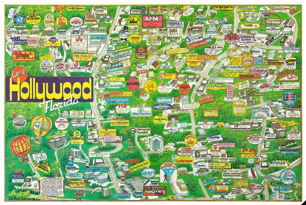
West Hollywood, Florida.
sold
This is a 1986 Robert Zell-Breier pictorial map of West Hollywood, California. Most likely meant as a promotional piece for the city, myriad businesses throughout the city are identified and range from the U.S. Post Office to hair salons, dry cleaners, auto centers, realtors, and Joe 'Z's' Meat Market. The now closed water park Six Flags Atlantis is situated in the lower right corner, while two hot air balloons, bearing advertisements of course, are illustrated in the lower left corner. Dentists, doctors, and hospitals are also promoted as are numerous banks and restaurants, including Gator Subs and Beverages and The Deli Den. (more details)
A wonderful view of the Panthéon in Paris - France's tribute to its most famous citizens.

Vue du Panthéon.
sold
- Digital Map Information
- Suitable for large format printing
- DPI: 600
- File Size: 14.63 MB
- File Type: ZIP / TIFF
- ICC color profile embedded
- Delivered instantly via download link
This is a c. 1845 Jules Arnout view of the Panthéon in Paris, France. The Panthéon, located in the Latin Quarter in the 5th arrondissement, was originally built as a church dedicated to St. Genevieve with the express purpose of houses the reliquary châsse containing her relics. The building was designed after a Greek cross with a massive portico inspired by the Pantheon in Rome. Construction on the Abbey of St. Genevieve, the patron saint of Paris, was completed in 1790. This, however, changed in 1791 during the French Revolution when the National Constituent Assembly declared that the Panthéon would be converted into a mausoleum for the internment of great Frenchmen. This secular monument has changed by to beig a church a handful of times, but today it plays the role of the burial place for French 'national heroes', some of whom include Voltaire, Rousseau, Alexandre Dumas, Jean Moulin, André Malraux, and Simone and Antoine Veil. (more details)
A patriotic propaganda piece that declares 'Remember Pearl Harbor' and touts America's ability to fight World War II.

Democracy in Action. Freedom Defense Recovery.
sold
- Digital Map Information
- Suitable for large format printing
- File Size: 17.95 MB
- File Type: ZIP / TIFF
- ICC color profile embedded
- Delivered instantly via download link
This is a 1941 Frank T. Perone pictorial map of the United States promoting American involvement in World War II. An outline of the continental United States on top of an American flag serves as the central image, with the phrase 'Freedom Defense Recovery' superimposed over the top. The F., D., and R. in the three words are large block letters each containing one of the words in smaller type, emphasizing the initials, which are the same as those of the President in 1941, Franklin Delano Roosevelt, F.D.R., and a portrait of the President is situated in the lower left corner.
Within the outlined United States, Freedom, Defense, and Recovery are illustrated by one large collage made up of those themes. Freedom, the furthest to the left, is depicted by a newspaper with the headline 'Free Press', a 1940s era microphone, a church with its steeple, and the Statue of Liberty. The newspaper, microphone, and church symbolize the Freedom of the Press, the Freedom of Speech, the Freedom of Religion, respectively, each of which are enshrined in the First Amendment to the United States Constitution. The Statue of Liberty is a recognizable symbol for freedom that is not associated with any specific form. Defense is, of course, symbolized by military strength. An airplane, a battleship, and a tank effectively summarize America's drive to win this war and a young man in uniform personifies who will be fighting it. Recovery is furthest to the right and is illustrated by a factory, a farmer plowing a field, and a cashier's window. It may sound crass, but the truth of the matter is that the United States finally pulled out of the Great Depression because of the effort that came with arming for war. America's economy had never functioned at such a high capacity before and, with that effort, finally was able to recover from a decade of economic depression. (more details)
Within the outlined United States, Freedom, Defense, and Recovery are illustrated by one large collage made up of those themes. Freedom, the furthest to the left, is depicted by a newspaper with the headline 'Free Press', a 1940s era microphone, a church with its steeple, and the Statue of Liberty. The newspaper, microphone, and church symbolize the Freedom of the Press, the Freedom of Speech, the Freedom of Religion, respectively, each of which are enshrined in the First Amendment to the United States Constitution. The Statue of Liberty is a recognizable symbol for freedom that is not associated with any specific form. Defense is, of course, symbolized by military strength. An airplane, a battleship, and a tank effectively summarize America's drive to win this war and a young man in uniform personifies who will be fighting it. Recovery is furthest to the right and is illustrated by a factory, a farmer plowing a field, and a cashier's window. It may sound crass, but the truth of the matter is that the United States finally pulled out of the Great Depression because of the effort that came with arming for war. America's economy had never functioned at such a high capacity before and, with that effort, finally was able to recover from a decade of economic depression. (more details)
Iconic pictorial map of Long Island, New York.
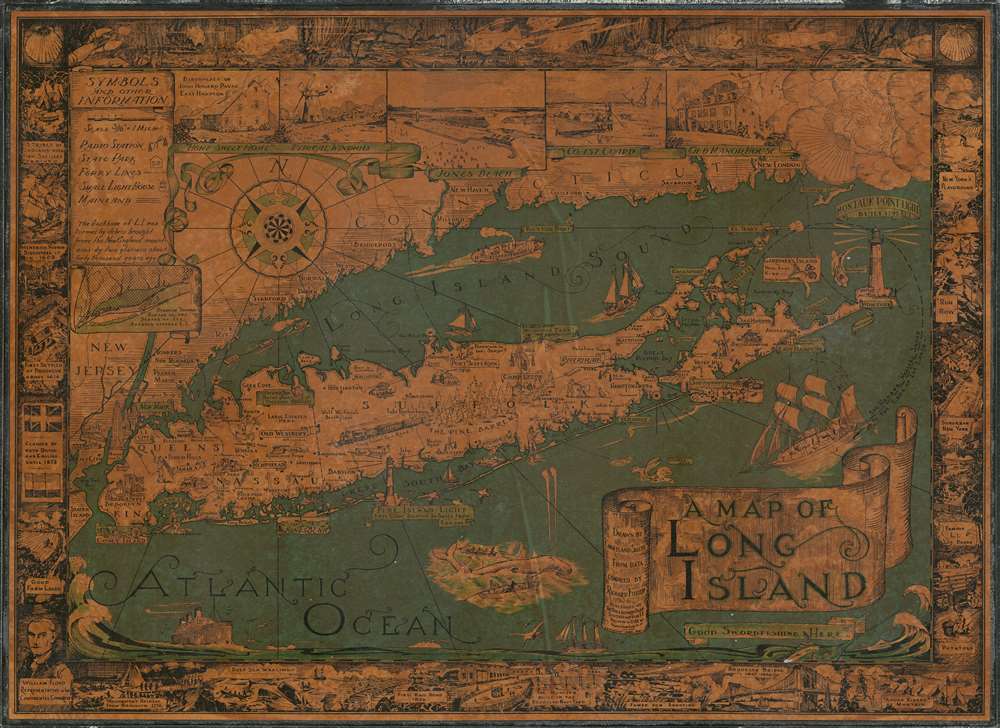
A Map of Long Island.
sold
- Digital Map Information
- Suitable for large format printing
- File Size: 50.71 MB
- File Type: ZIP / TIFF
- ICC color profile embedded
- Delivered instantly via download link
This is a charming 1961 pictorial map of Long Island by Courtland Smith. This historical map covers from New London in Connecticut and Fishers Island south as far as the Lower New York Bay and Staten Island. Long Island is depicted in its entirety from Brooklyn and Queens east to Montauk. Throughout, the map notes cities, towns, beaches, radio stations, parks, ferry lines, lighthouses and several other important landmarks, scenes and activities. Several landmarks have been attractively illustrated, including the Montauk Point Light, Fire Island Light, Southampton, Coney Island, etc. Facts about Gardiner's Island - 'here Capt. Kidd buried loot' and Oyster Park 'Burial Place of Theodore Roosevelt' are noted.
The top left quadrant of the map includes the note, 'The backbone of L.I. was formed by debris brought from the New England Mountains by two glaciers about forty thousand years ago' as well as an inset featuring a 'Diagram showing how far the two Stages of Ice Advance covered L.I.' Five beautiful illustrated views along the top border include the Birthplace of John Howard Payne East Hampton, a Typical Windmill, Jones Beach, Coast Guard and Old Manor House. A decorative compass rose and an art deco style wind figure are also featured. In Long Island Sound and the Atlantic Ocean, pictorial illustrations of Boston Boat, ships, striped bass, a swordfish, whale fishing, and the Sag Harbor Whalers that 'sailed to the ends of the Earth' can be seen. The map is surrounded by an elaborate border, with underwater scenes at the top and historic events and places along the remaining three sides, including the '13 Tribes of Indians when First Settlers Arrived,' 'First Settled at Brooklyn in 1614,' 'First Rail Road 1836,' 'Brooklyn Bridge 1867-1883,' etc. (more details)
The top left quadrant of the map includes the note, 'The backbone of L.I. was formed by debris brought from the New England Mountains by two glaciers about forty thousand years ago' as well as an inset featuring a 'Diagram showing how far the two Stages of Ice Advance covered L.I.' Five beautiful illustrated views along the top border include the Birthplace of John Howard Payne East Hampton, a Typical Windmill, Jones Beach, Coast Guard and Old Manor House. A decorative compass rose and an art deco style wind figure are also featured. In Long Island Sound and the Atlantic Ocean, pictorial illustrations of Boston Boat, ships, striped bass, a swordfish, whale fishing, and the Sag Harbor Whalers that 'sailed to the ends of the Earth' can be seen. The map is surrounded by an elaborate border, with underwater scenes at the top and historic events and places along the remaining three sides, including the '13 Tribes of Indians when First Settlers Arrived,' 'First Settled at Brooklyn in 1614,' 'First Rail Road 1836,' 'Brooklyn Bridge 1867-1883,' etc. (more details)
Published only five years after the completion of the first transcontinental railroad and during an era of rail expansion in the United States.
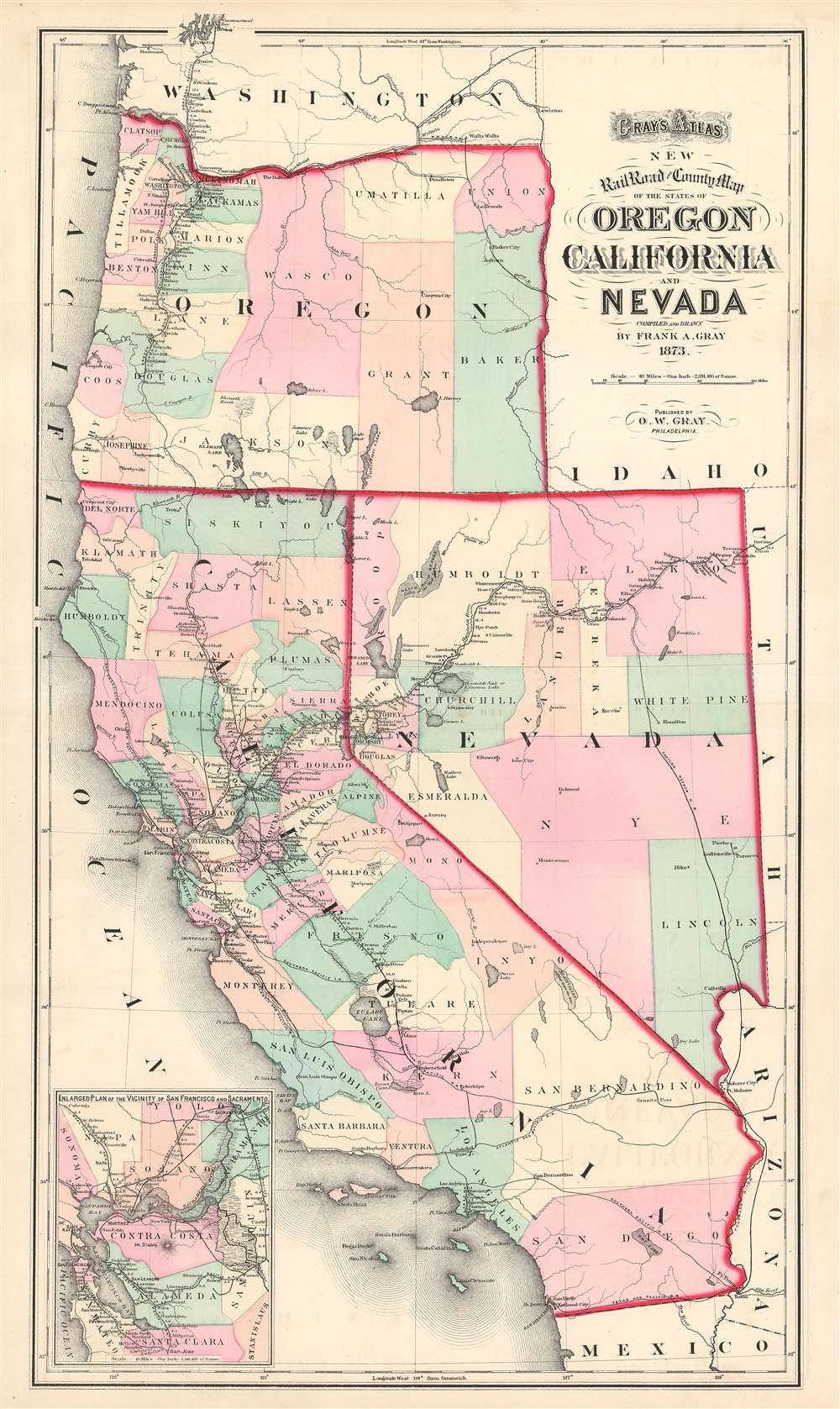
Gray's Atlas New Railroad and County Map of the States of Oregon California and Nevada.
sold
- Digital Map Information
- Suitable for large format printing
- File Size: 21.87 MB
- File Type: ZIP / TIFF
- ICC color profile embedded
- Delivered instantly via download link
This is an 1873 Ormando Gray Map of California, Nevada, and Oregon. The map depicts the region from the Pacific Ocean to Idaho, Utah, and Arizona, and from Washington to Mexico. Published near the height of railroad expansion, the rail lines take center stage. The routes of the Central Pacific, Eastern Nevada, Southern Pacific, Atlantic and Pacific, Texas and Pacific, San Francisco and Northern Pacific, Napa Valley, Oregon and California, Oregon Central, and Northern Pacific Railroads are all illustrated and labeled. The Central Pacific Railroad, begun in 1862, constructed the western portion of the first transcontinental railroad, when it met the Union Pacific at Promontory Summit in the Utah Territory in 1869. Thus, rail travel at the forefront of the popular imagination when this map was published. Stops along all the routes are identified and distances between then are provided. Counties in California, Nevada, and Oregon are illustrated and labeled as well. They are also shaded different colors to allow for easy differentiation. An inset map of the vicinity of San Francisco and Sacramento is situated in the lower left corner. Much like the larger map, the inset map highlights the rail network in the area, complete with a most, if not all, of the stops along each route and the distances between them. (more details)
Brightly colored and highly detailed pictorial map of mammals and birds native to the United States.

Sportsman's Map of U.S. Wildlife.
sold
- Digital Map Information
- Suitable for large format printing
- File Size: 83.71 MB
- File Type: ZIP / TIFF
- ICC color profile embedded
- Delivered instantly via download link
This is a 1956 Ira Moss pictorial map of wildlife and game native to the United States. The map depicts the region from Canada to Mexico and from the Pacific Ocean to the Atlantic Ocean. Bright, colorful, and highly detailed, fifty-five different mammal species ... (more details)
The best, largest, and most important map of Beijing made before World War II.

Surveyed Map of Inner City and Outer City, Beijing. /實測北平市内外城地形圖
sold
- Digital Map Information
- Suitable for large format printing
- DPI: 600
- File Size: 416
- File Type: ZIP / TIFF
- ICC color profile embedded
- Delivered instantly via download link
The best, largest, and most important map of Beijing made before World War II. This is an astounding wall-sized Republic of China era administrative map of Beijing (Beiping) dating to January 1937 (Mingou 26). This map was issued just months before the Marco Polo Bridge Incident, the Battle of Beiping-Tianjin, the opening of the Second Sino Japanese War, and the subsequent Japanese occupation of Beijing. Measuring 85.5 x 79.5 in (217.17 x 201.93 cm), this enormous work is the largest and most detailed map of Beijing (or Beiping) yet produced. When commissioned by 21st Beijing mayor Yuan Liang (袁良, 1882–1953), more than 10 years had passed since the last major map of Beijing was issued - which was both on a smaller scale and inaccurate. (more details)
A map illustrating the electoral districts in the first parliamentary election after the reunification of Vietnam in 1975.
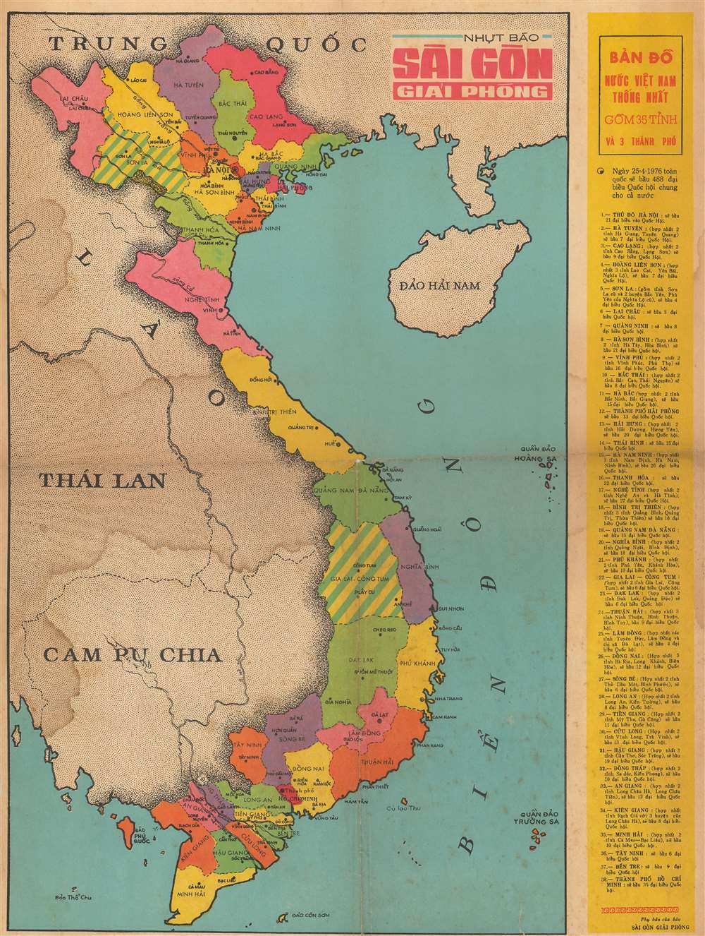
BẢN ĐỒ NUỐC VIỆT NAM THỐNG NHẤT GỒM 35 TỈNH VÀ 3 THÀNH PHỐ. / Vietnamese United Nations Map Included 35 Provinces and 3 Cities.
sold
This is a 1976 Saigon Giai Phong map of Vietnam illustrating the districts created for the 1976 parliamentary elections, the first parliamentary elections in Vietnam after the end of the Vietnam War (1955 - 1975) and the reunification of North and South Vietnam. The map depicts the region from Thailand to Hainan and from Yunnan Province in China to the Cà Mau Peninsula. Vietnam is divided into thirty-eight different parliamentary districts. These are divided between thirty-five provinces and three cities: Hanoi, Haiphong, and Ho Chi Minh City. Cities and towns throughout the country are labeled, including Hanoi, Haiphong, Hué, and Da Nang. A list of all thirty-eight districts, that includes a breakdown of how the delegates will be allotted, is included along the right border. (more details)
A view of New York highlighting the ever-increasing industral might of the city.

Greatest New York.
sold
- Digital Map Information
- Suitable for large format printing
- File Size: 26.91 MB
- File Type: ZIP / TIFF
- ICC color profile embedded
- Delivered instantly via download link
This is a 1911 Henry Wellge bird's-eye view of New York City and environs. The view depicts the region from Newark and Passaic, New Jersey to Long Island and the Atlantic Ocean and from the Harlem River to Staten Island. Beautifully illustrated, myriad buildings throughout the region are rendered. Although individual buildings are not labeled, some landmarks, particularly the bridges over the East River and the Statue of Liberty are easily recognizable. Central and Riverside Park are shockingly open spaces in the otherwise cramped borough of Manhattan. Ships and boats of all sizes ply the waters of the East and Hudson Rivers and the Upper Bay. The docks in Red Hook, Gravesend Bay, Coney Island, and Jamaica Bay are identifiable in Brooklyn. The factories in Bayonne and other parts of New Jersey are easily noticed, highlighted by the large plumes of smoke rising from their smokestacks. The region's railroads are also illustrated, some of which are labeled. (more details)
The largest American pictorial map of China to predate World War II.
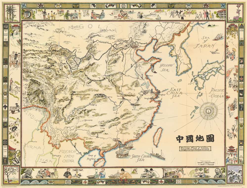
Picture Map of China. 中國地圖
sold
- Digital Map Information
- Suitable for large format printing
- File Size: 89.86 MB
- File Type: ZIP / TIFF
- ICC color profile embedded
- Delivered instantly via download link
This is a striking large format 1932 pictorial wall map of China illustrated by Frank Randolph Southard in 1932. The map covers all of China as well as neighboring Korea and parts of Japan. It is surrounded by an elaborate decorative border featuring Chinese iconography as well as views of Chinese street and country life. The map embraces the romanticized view of Chinese life and culture that many Americans held before World War II. It is moreover, the only large format American pictorial map of China to be issued before the war. While the present map is uncolored, Southard intended the map to be colorized by the buyer. (more details)
Depicts both the N.U. Coliseum and Memorial Stadium and states that There Is No Place Like Nebraska.

Ye Mappe of Ye Good Old University of Nebraska and Adjacent Parts Etc-Etc and Et Cetera in Dear Olde Lincoln Nebraska. / Ye Mappe of Ye Universitas Nebraskensis and Adjacent Parts.
sold
- Digital Map Information
- Suitable for large format printing
- File Size: 36.25 MB
- File Type: ZIP / TIFF
- ICC color profile embedded
- Delivered instantly via download link
This is a 1931 James H. Pickering pictorial map of the University of Nebraska in Lincoln, Nebraska. The map depicts the region from 9th Street to 17th Street and from the State Fairgrounds to M Street. Wonderfully illustrated, buildings across campus and downtown Lincoln are illustrated and labeled, including Morrill Hall, Andrews Hall, Bessey Hall, and Brace Laboratory, the four of which are still standing on campus and host classes. Others, such as the Law College, the library, and the Teacher's College have since been demolished and moved to other locations on campus. Two fixtures on campus, the N.U. Coliseum and Memorial Stadium are also illustrated, with Dana X. Bible, then the head coach of the Nebraska Cornhuskers football team, shown standing on the practice field just outside Memorial Stadium. Fraternity and sorority houses seep to be everywhere, with over a dozen located on campus along 16th Street and along R Street, while numerous others are highlighted in 'bubbles' that provide the address of the house and which fraternity or sorority lives there.
Outside campus, the offices of the Nebraska State Journal (now the Lincoln Journal-Star), the Lincoln Telephone and Telegraph Building, and the public library are among the highlighted sites. The Cornhusker Hotel is depicted in the same location as it is today, between 12th and 13th Street on M Street, and the dome of the Nebraska State Capital makes an appearance in the lower right quadrant. It is important to note that the Agriculture College, today known as East Campus, is illustrated in the upper right corner near the intersection of 33rd and Holdrege Streets.
This map is definitely not a typical city or campus map. Myriad comical illustrations and asides are included throughout, including a pair of dinosaurs 'having a go at puppy love' in the upper right corner, not far from a 'poor ol' buffalo' and some 'Cornhuskers husking corn between classes'. The 'secret societies' of the university, Mortar Board and the Innocents Society, also make an appearance, in the open space near the Administration Building and Pharmacy Hall. Students, deans, and even the campus prowler are also illustrated. Night and day both appear in the sky, with 'Old Man Moon' and 'Old Sol Himself' making an appearance. A short history of the university is situated along the left border that ends with the schools unofficial official motto, 'There Is No Place Like Nebraska'. (more details)
Outside campus, the offices of the Nebraska State Journal (now the Lincoln Journal-Star), the Lincoln Telephone and Telegraph Building, and the public library are among the highlighted sites. The Cornhusker Hotel is depicted in the same location as it is today, between 12th and 13th Street on M Street, and the dome of the Nebraska State Capital makes an appearance in the lower right quadrant. It is important to note that the Agriculture College, today known as East Campus, is illustrated in the upper right corner near the intersection of 33rd and Holdrege Streets.
This map is definitely not a typical city or campus map. Myriad comical illustrations and asides are included throughout, including a pair of dinosaurs 'having a go at puppy love' in the upper right corner, not far from a 'poor ol' buffalo' and some 'Cornhuskers husking corn between classes'. The 'secret societies' of the university, Mortar Board and the Innocents Society, also make an appearance, in the open space near the Administration Building and Pharmacy Hall. Students, deans, and even the campus prowler are also illustrated. Night and day both appear in the sky, with 'Old Man Moon' and 'Old Sol Himself' making an appearance. A short history of the university is situated along the left border that ends with the schools unofficial official motto, 'There Is No Place Like Nebraska'. (more details)
Includes insets of some of the best surfing locations in the world, including the North Shore on Oahu, Honolua Bay on Maui, and Hanalei Bay on Kauai.
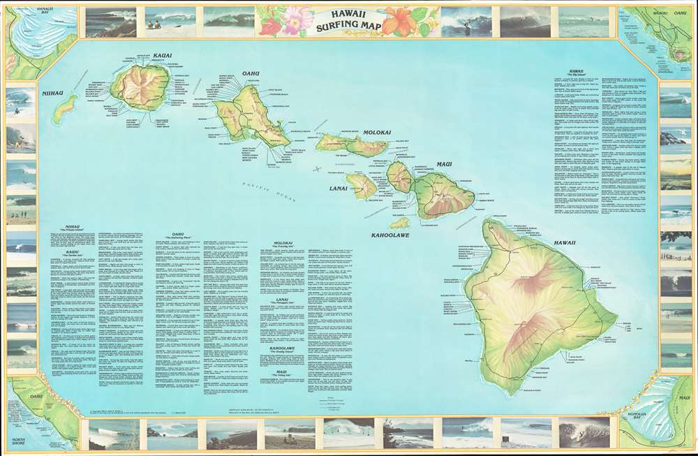
Hawaii Surfing Map.
sold
This is a 1982 Allen B. Wright Jr. surfing map of Hawaii. The map depicts all eight islands in the archipelago with Nihau on the left and Hawaii on the right. Each island is labeled, as are cities and towns on each island, except for Kahoolawe and Nihau. Roads are illustrated as well, including ungraded dirt or jeep trails. Most importantly for this piece is that myriad surfing locales are identified along the coast of the islands, with short descriptions of a large number of them appearing in the lower left corner as well as the upper right, where descriptions of the beaches on the island of Hawaii are situated. The whole is surrounded by a border featuring color photographs of swells and surfers. Four inset maps occupy the four corners and illustrate Hanalei Bay on Kauai, Waikiki and the North Shore on Oahu, and Honolua Bay on Maui. The surfing at Hanalei Bay is the best on Kauai, while Honolua Bay, if the surf is right, can provide some of the best surfing around. Waimea Bay and Pipeline on the North Shore, however, are world famous, while the North Shore has some of the world's finest beaches and bays. (more details)
One of the most popular Johnson maps among American Southwest aficionados.
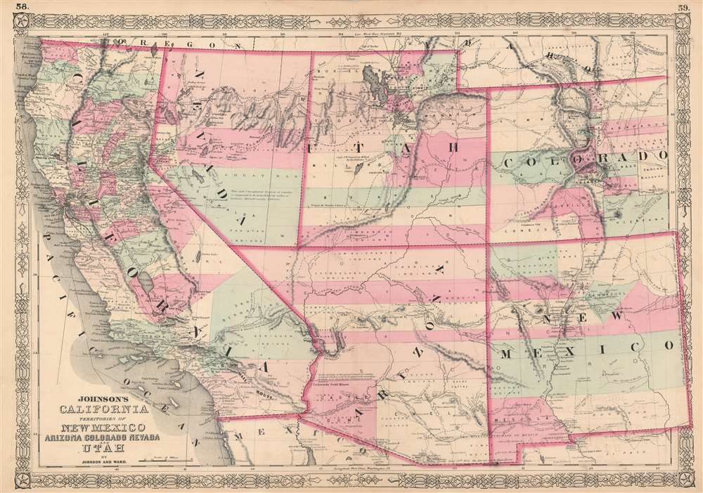
Johnson's California. Territories of New Mexico Arizona Colorado Nevada and Utah.
sold
- Digital Map Information
- Suitable for large format printing
- File Size: 29.69 MB
- File Type: ZIP / TIFF
- ICC color profile embedded
- Delivered instantly via download link
One of the scarcest and most historically significant of A. J. Johnson's southwest series. Published in 1863 at the height of the American Civil War, this stunning map depicts the state of California and the territories of Nevada, Utah, Colorado, New Mexico and Arizona. The map offers superb detail throughout, noting mining districts, emigrant trails, the Santa Fe Trail, the Pony Express Route, and several proposed railroads, as well as American Indian tribes, geological features, and local political divisions. (more details)
A thematic map of Argentina highlighting the country's agricultural production.

Republica Argentina: Superficie, Poblacion, Ferro-Carriles, Cultivos Y Ganados.
sold
- Digital Map Information
- Suitable for large format printing
- File Size: 41.07 MB
- File Type: ZIP / TIFF
- ICC color profile embedded
- Delivered instantly via download link
This is a 1910 Herrera and Dolarea thematic agricultural map of Argentina. The map depicts the region from the Pacific Ocean to the Atlantic Ocean and from Bolivia and Paraguay to Cape Horn and Tierra del Fuego. Divided into three regions and twenty-three different provinces, each province is labeled and the area and population of each are given, along with the kilometers of railroad track present in each province. Then a list of agricultural products produced in each province is present, some of which include corn, wheat, alfalfa, and fruits, measured in the number of hectares farmed. Then livestock raised (measured in number of animals) are listed, which include cattle, sheep, horses, goats, and pigs. Cities are noted, though unlabeled, and connected by red lines, which are most likely railroads. Some of these are dotted lines, indicating routes that are either projected or currently under construction. The fact that the cities are unlabeled implies that the creators believed that their audience would have an in-depth knowledge of Argentine geography which meant that identifying the cities was not necessary. (more details)
WWII Map of the Philippines.
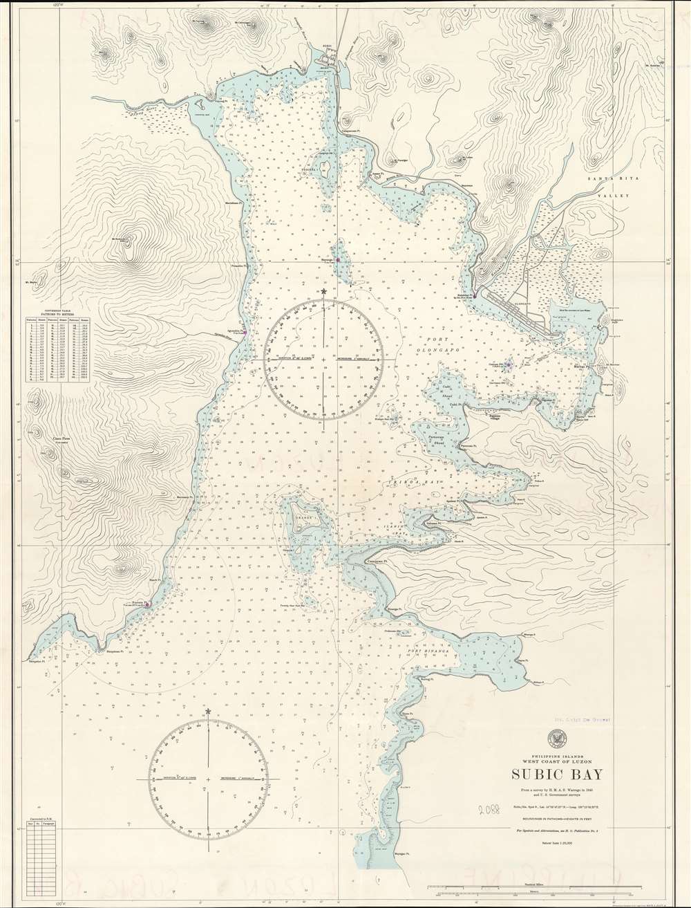
Philippine Islands. West Coast of Luzon. Subic Bay.
sold
- Digital Map Information
- Suitable for large format printing
- File Size: 45.23 MB
- File Type: ZIP / TIFF
- ICC color profile embedded
- Delivered instantly via download link
This is a 1945 U.S. Navy Hydrographic map of Subic Bay on the west coast of Luzon in the Philippine Islands. The map depicts the region from Sampaloc Point to the Santa Rita Valley and from Subic City to Mayagao Point. Highly detailed, myriad depth soundings are noted throughout. Points, ports, and shoals are labeled. The town of Subic is situated at the head of the bay, while Olongapo is located along the bay's eastern coast. Numerous rivers are identified, as are mountains and swamps. (more details)
Nautical Chart including Hong Kong and disputed South China Sea territory near Vietnam!

East India Archipelago. [Western Route to China. Chart No. 5.]
sold
- Digital Map Information
- Suitable for large format printing
- File Size: 116.5 MB
- File Type: ZIP / TIFF
- ICC color profile embedded
- Delivered instantly via download link
This is an uncommon 1878 James Imray map of the South China Sea region between Hong Kong, Hainan, and Vietnam. The chart covers from the Pearl River Delta, south past and including Hainan, and most of the coast of Vietnam to, roughly Saigon There are inset detail maps of Hong Kong, Nha-Trang, Cam-Ranh, Port Xuan-Dai, Touron Bay, Cape Boung-Quioua, Yu-Lin-Kan, Gaalong Bay (Yalang Wan). The map was used for actual navigation and there are pencil marks and manuscript updates associated with maritime use. It bears an 'Imray and Son 1880' stamp suggesting there may be printed updates, but his is not 100% clear as charts were not updated as frequently as one might think. (more details)
A view of the Palais des Tuileries, a royal and imperial residence in Paris that was destroyed by the Paris Commune in 1871.

Vue de la Place du Carrousel.
sold
- Digital Map Information
- Suitable for large format printing
- DPI: 600
- File Size: 12.83 MB
- File Type: ZIP / TIFF
- ICC color profile embedded
- Delivered instantly via download link
This is a c. 1845 Jules Arnout view of the Place du Carrousel and the Palais des Tuileries (Tuileries Palace) in Paris, France. The view illustrates the Place du Carrousel from the east and depicts a typical day in Paris. Parisians rush across the square, on foot, on horseback, and in carriages. All this activity takes place in the shadow of the Arc de Triomphe du Carrousel, constructed to commemorate Napoleon's military victories between 1806 and 1808. Based on the Arch of Constantine in Rome, the Arc de Triomphe du Carrousel is topped by the Horses of Saint Mark from Saint Mark's Cathedral in Venice, which were brought to Paris by Napoleon in 1798 after he captured Venice. Behind the Arc de Triomphe du Carrousel stands the Palais de Tuileries. This palace was the main royal residence for French monarchs from Henry IV through Napoleon III until it was burned down by the Paris Commune in 1871. The Palais des Tuileries was never rebuilt, although a campaign advocating for its reconstruction has been ongoing since 2003. (more details)