
A charming map of Georgia illustrating the lands of both the Cherokee and Creek.
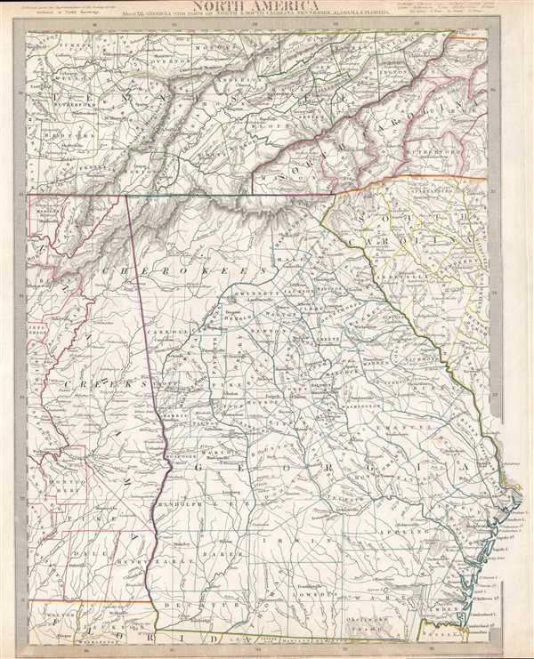
North America Sheet XII. Georgia, with Parts of North and South Carolina, Tennessee, Alabama and Florida.
sold
- Digital Map Information
- Suitable for large format printing
- Full resolution TIFF file
- ICC color profile embedded
- Delivered instantly via download link
This is an uncommon 1833 Society for the Diffusion of Useful Knowledge map of Georgia and parts of Tennessee, Alabama, North Carolina and South Carolina. It depicts the region from the Kentucky-Tennessee border to Florida and from Nashville, Tennessee and ... (more details)
One of the most decorative maps of Tierra del Fuego and the Strait of Magellan.
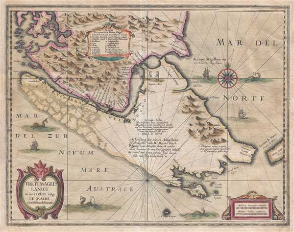
Freti Magellanici ac novi Freti vulgo Le Maire exactissim delineatio.
sold
- Digital Map Information
- Suitable for large format printing
- DPI: 300
- File Size: 10.36 MB
- File Type: ZIP / TIFF
- ICC color profile embedded
- Delivered instantly via download link
This is a 1638 Jodocus Hondius and Jan Jansson map of the Strait of Magellan and Tierra del Fuego, the southernmost tip of South America from the golden age of Dutch cartography. The map depicts the region from mainland Patagonia to Tierra del Fuego, Cape ... (more details)
A charming pictorial map promoting Martha's Vineyard as a vacation destination.
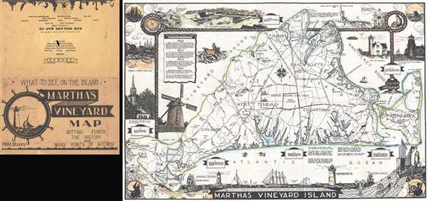
Martha's Vineyard Island.
sold
- Digital Map Information
- Suitable for large format printing
- File Size: 9.82 MB
- File Type: ZIP / TIFF
- ICC color profile embedded
- Delivered instantly via download link
This is a c. 1935 L. H. Parker pictorial map of Martha's Vineyard. The map depicts the entirety of Martha's Vineyard from Gay Head and Gay Head Lighthouse to Chappaquiddick Island and from the West Chop Lighthouse to the Atlantic Ocean. Each of Martha's ... (more details)
Representation of the Spanish holdings in North America.
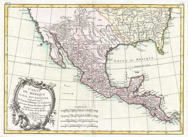
Carte du Mexique ou de la Nlle. Espagne Contenant aussi le Nouveau Mexique, la Californie, avec une Partie des Pays adjacents.
sold
- Digital Map Information
- Suitable for large format printing
- DPI: 300
- File Size: 5.03 MB
- File Type: ZIP / TIFF
- ICC color profile embedded
- Delivered instantly via download link
This is a 1771 Rigobert Bonne map of Mexico and Florida. The map depicts the region from Baja California eastward to Florida and Carolina, and from the northwards mouth of the Chesapeake Bay to Panama. Bonne, being a very cautious cartographer, ... (more details)
A highly detailed and charmingly engraved strip map of the St. Lawrence River - over 8 feet long.

The Phat Boy's Delineations of the St. Lawrence River.
sold
- Digital Map Information
- Suitable for large format printing
- File Size: 24.23 MB
- File Type: ZIP / TIFF
- ICC color profile embedded
- Delivered instantly via download link
This is an 1885 George Ramsdell strip map of the St. Lawrence River. Oriented toward the northeast, the map depicts the river from Lake Ontario to Montreal, noting the steamboat channel along the entire length of the map. Cities and towns are ... (more details)
One of the maps in the Greater CoProsperity Sphere series and one of the most cartographically beautiful 20th century maps of New Zealand.

New Zealand.
sold
- Digital Map Information
- Suitable for large format printing
- File Size: 12.96 MB
- File Type: ZIP / TIFF
- ICC color profile embedded
- Delivered instantly via download link
This is a stunning large format Japanese map of New Zealand dating to World War II, one of the maps in the Greater East Asia Co-Prosperity Sphere set. It is one of the most beautiful cartographic depictions of New Zealand to appear in the ... (more details)
A golf themed political cartoon mocking the continuing Alaska boundary dispute between the United States and Canada.
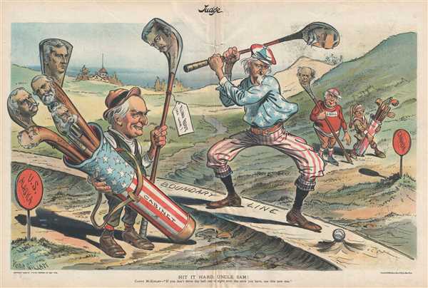
Hit It Hard, Uncle Sam!
sold
- Digital Map Information
- Suitable for large format printing
- File Size: 8.61 MB
- File Type: ZIP / TIFF
- ICC color profile embedded
- Delivered instantly via download link
This is a golf-themed Victor Gillam political cartoon from the August 19,1899 issue of Judge magazine most likely mocking the government's inability to reach an acceptable resolution to the Alaska boundary dispute between Canada and the United States. Gillam's cartoon illustrates Uncle Sam playing a round of golf with John Bull, his British counterpart. President McKinley is acting as Uncle Sam's caddy, carrying a star-spangled golf bag that reads 'Cabinet' and is filled with clubs bearing caricatures of different cabinet secretaries. Bull's caddy is Canada, and they watch while Uncle Sam prepares to hit a golf ball labeled 'Alaskan Dispute' with a club labeled Hay, a reference to John Hay, McKinley's Secretary of State. Hay was a very successful politician and diplomat, serving in various government capacities from Lincoln's administration until his death while serving as President Theodore Roosevelt's Secretary of State. The caption, stated by McKinley, reads, 'If you don't drive the ball out of sight with the stick you have (Hay), use this new one (labeled as the driver and bearing the likeness of Elihu Root, then the Secretary of War). (more details)
An attractive 19th century map of the West Indies.

West India Islands.
sold
- Digital Map Information
- Suitable for large format printing
- DPI: 300
- File Size: 4.06 MB
- File Type: ZIP / TIFF
- ICC color profile embedded
- Delivered instantly via download link
This is an 1851 John Tallis map of the Caribbean or West Indies. The map depicts the region from Cuba and the Caribbean coast of Central America to Barbados and from southern Florida to Colombia and the mouth of the Orinoco River. Each of ... (more details)
The first edition of Johnson's map of Florida.

Johnson's Florida.
sold
- Digital Map Information
- Suitable for large format printing
- File Size: 5.99 MB
- File Type: ZIP / TIFF
- ICC color profile embedded
- Delivered instantly via download link
This is a beautiful example of A. J. Johnson and Ross C. Browning's 1860 first edition map of Florida. The map illustrates Florida in full, with color coding according to county. Cartographically, this map is based upon the J. H. Colton ... (more details)
The first edition of Johnson's map of the world in hemispheres.

Johnson's Western Hemisphere. / Johnson's Eastern Hemisphere.
sold
- Digital Map Information
- Suitable for large format printing
- File Size: 13.96 MB
- File Type: ZIP / TIFF
- ICC color profile embedded
- Delivered instantly via download link
This is a beautiful example of A. J. Johnson and Ross C. Browning's 1860 first edition map of the world on a hemispherical projection. Offering a fascinating snapshot of the world during a period of rapid globalization and discovery, ... (more details)
The first edition of one of the finest mountains and rivers charts of the 19th century.

Mountains and Rivers.
sold
- Digital Map Information
- Suitable for large format printing
- File Size: 12.13 MB
- File Type: ZIP / TIFF
- ICC color profile embedded
- Delivered instantly via download link
One of the finest Mountains and River's Chart published in the mid-19th century. This is the 1860 first edition of A. J. Johnson and Ross C. Browning's chart or map of the relative distances of the world's great rivers and the ... (more details)
A vibrantly colored map of the Capital of the United States.

The 'Standard Guide' Ready Reference Map of Washington, to accompany the 'Washington Standard Guide'.
sold
- Digital Map Information
- Suitable for large format printing
- File Size: 10.53 MB
- File Type: ZIP / TIFF
- ICC color profile embedded
- Delivered instantly via download link
This is an appealing 1912 map or plan of Washington D.C. by the Foster and Reynolds Company of Washington. It covers Washington D.C. from the Arlington National Cemetery eastward as far as 28th Street and the Congressional ... (more details)
Gorgeous map of the Lesser Antilles that labels St. Lucia, Barbados, and Puerto Rico.
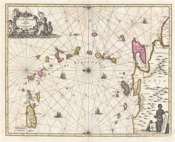
Insula S. Juan de Puerto Rico Caribes; Vel Canibasum Insulae.
sold
- Digital Map Information
- Suitable for large format printing
- DPI: 300
- File Size: 8.88 MB
- File Type: ZIP / TIFF
- ICC color profile embedded
- Delivered instantly via download link
This is an attractive c. 1700 map of the Lesser Antilles by Petrus Schenk and Gerard Valk based on a 1650 map by Jan Jansson. Oriented toward the east, the map depicts the region from Puerto Rico to Venezuela and from the ... (more details)
A beautiful early 18th century map of Asia Minor.

Natolia, quae olim Asia Minor.
$550.00
Acquire
- Digital Map Information
- Suitable for large format printing
- DPI: 300
- File Size: 10.72 MB
- File Type: ZIP / TIFF
- ICC color profile embedded
- Delivered instantly via download link
This is an attractive c. 1708 map of Turkey or Asia Minor. Issued by Petrus Schenk and Gerard Valk, it was engraved in 1636 by Henry Hondius, based on the 1634 map by Johannes Blaeu. The map depicts the region from the ... (more details)
A cartoon satirizing the ability of Mormons in Utah to resist federal efforts to outlaw polygamy.

Utah Defiant - The Mormon Commander Mustering His Forces.
sold
- Digital Map Information
- Suitable for large format printing
- File Size: 8.57 MB
- File Type: ZIP / TIFF
- ICC color profile embedded
- Delivered instantly via download link
This is an 1889 Joseph Ferdinand Keppler political cartoon lampooning Mormon resistance to federal efforts to end the Mormon practice of polygamy for Puck magazine. Taking a humorous approach to a very serious subject, Keppler illustrates various 'units' of the Mormon defense. The 'old guard', situated in the upper left corner, are wearing coal-scuttle helmets and armed with broomsticks, while the 'corps of reserve wives' 'would keep up a heavy, raking fire of pillows from their bedstead stronghold'. The 'extra reserve', behind their fortifications of pots and pans, would lob wash-tub artillery at U.S. troops. The 'young recruits', pictured in the upper-right corner, are armed with umbrellas tipped with knives, forks, and scissors, and the Infant-ry wails their support just below. The Salt Lake Navy plies the waters of the Great Salt Lake in wash-tubs complete with sails and large bottles of bitters for cannons between the 'young recruits' and the 'old guard'. All this action surrounds Mr. Elder John Taylor, 'the chief rooster of the territory' per Puck. (more details)
Highlights the areas in which major battles were fought between 1862 and 1865 - including Gettysburg, Antietam, and the Siege of Petersburg.
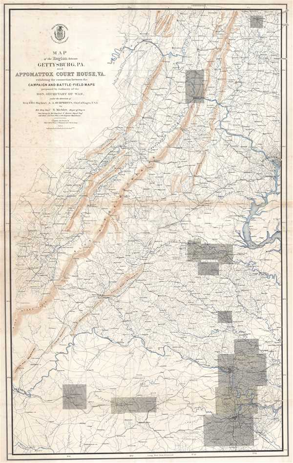
Map of the Region between Gettysburg, PA. and Appomattox Court House, VA. Exhibiting the connection between the Campaign and Battle-Field Maps.
sold
- Digital Map Information
- Suitable for large format printing
- File Size: 27.36 MB
- File Type: ZIP / TIFF
- ICC color profile embedded
- Delivered instantly via download link
This is an 1869 separate-issue Nathaniel Michler map of the eastern United States stretching from Pennsylvania to Virginia marking the locations of major battles during the American Civil War. The map depicts the ... (more details)
One of the more attractive 19th century commercial atlas maps of Boston.
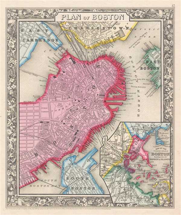
Plan of Boston.
sold
- Digital Map Information
- Suitable for large format printing
- File Size: 4.25 MB
- File Type: ZIP / TIFF
- ICC color profile embedded
- Delivered instantly via download link
This is an 1861 Samuel Augustus Mitchell, Jr. map of Boston, Massachusetts. The map depicts Boston along with parts of East Cambridge, Charlestown, East Boston, and South Boston. Parks, individual streets, ... (more details)
Highlights the American transportation system in the years leading up to World War II.

Map No. 1.
sold
- Digital Map Information
- Suitable for large format printing
- File Size: 12.04 MB
- File Type: ZIP / TIFF
- ICC color profile embedded
- Delivered instantly via download link
This is a 1938 Francis Raymond Elms map of the United States which depicts the continental United States from the Pacific Ocean to the Atlantic Ocean and from Canada to Mexico. Created during the tense ... (more details)
Stunning wall map of Ireland!

A Map of the Kingdom of Ireland, divided into provinces, counties and baronies. Southern section. Shewing the archbishopricks, bishopricks, cities, boroughs, market towns, villages, barracks, mountains, lakes, bays, rivers, bridges, ferries, passes, also the great, the branch & the by post roads together with the inland navigation, by J. Rocque, Chorographer to His Majesty.
sold
- Digital Map Information
- Suitable for large format printing
- DPI: 300
- File Size: 52.1 MB
- File Type: ZIP / TIFF
- ICC color profile embedded
- Delivered instantly via download link
An absolutely stunning and monumental 1794 wall map of Ireland by Jean Rocque. Covers Ireland in full with extraordinary detail throughout. Notes every town, hamlet, bishopric, country, forest, castle ... (more details)
Unusual early locally produced view of Swampscott, Massachusetts.

Swampscott, Essex County Mass., 11 Miles from Boston.
sold
- Digital Map Information
- Suitable for large format printing
- File Size: 9.49 MB
- File Type: ZIP / TIFF
- ICC color profile embedded
- Delivered instantly via download link
This is a rare 1871 locally produced view of Swampscott, Essex County, Massachusetts. The view was issued by John L. Robinson, likely to promote his Swampscott real estate interests. The views are two-color lithograph versions of photographs taken by Frederick M. Smith of Boston. The piece consists of four views on a single sheet:
- View from Inner Ledge of Phillips Point
- View from Lincoln House towards Lynn
- View from the Heights at the head of Burrill St.
- View from Red Rock, Lynn