
A pictorial map of Oahu published two months after the attack on Pearl Harbor. The map illustrates the transition of Hawaii from a remote Paradise to a key battleground in a global war.
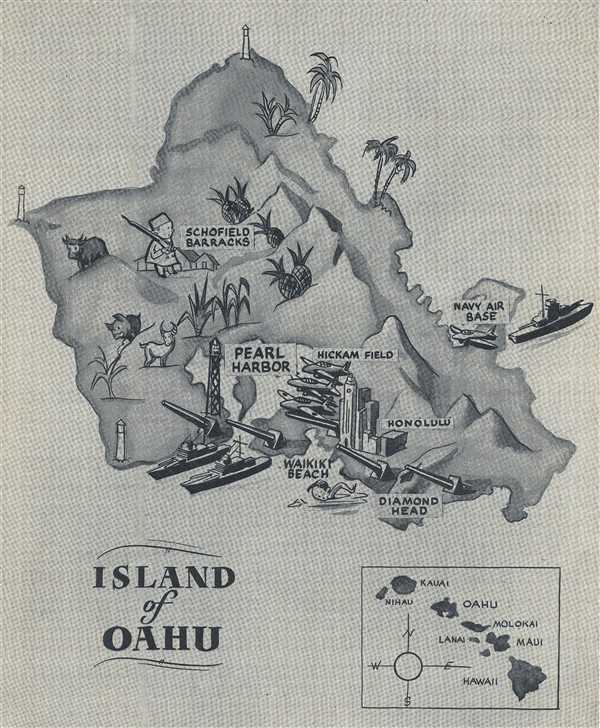
Island of Oahu.
sold
- Digital Map Information
- Suitable for large format printing
- File Size: 4.12 MB
- File Type: ZIP / TIFF
- ICC color profile embedded
- Delivered instantly via download link
This is a 1942 pictorial map of Oahu, Hawaii published in The Guitarist , a special interest magazine. The map depicts the entire island of Oahu from Kawela Bay to Diamond Head and from Kaena Point to Makapu'u Point. The military installations identified are Pearl ... (more details)
A graphically stunning postcard image celebrating the 'Kiss of Oceans' at the Panama Canal.

Meeting of the Atlantic and Pacific. 'The Kiss of the Oceans'.
sold
- Digital Map Information
- Suitable for large format printing
- File Size: 0.6 MB
- File Type: ZIP / TIFF
- ICC color profile embedded
- Delivered instantly via download link
This is a 1932 Isaac L. Maduro, Jr. postcard map of the western hemisphere. The map depicts the region from the Pacific Ocean to the Atlantic Ocean and from Canada to Cape Horn. Created to celebrate the Panama Canal, 'the kiss of the oceans', the artistic focus of ... (more details)
An incredible map created in 1943 tracing the events of World War II until that point.
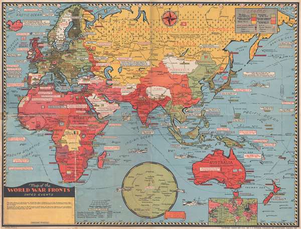
Map of the World War Fronts. Dated Events.
sold
- Digital Map Information
- Suitable for large format printing
- File Size: 11.76 MB
- File Type: ZIP / TIFF
- ICC color profile embedded
- Delivered instantly via download link
This is a 1943 Stanley Francis Turner map of Europe, Asia, and Africa during World War II. The map depicts from the Atlantic Ocean to the International Date Line, the Aleutian Islands, and Midway Island in the Pacific Ocean and from the Arctic Ocean and the ... (more details)
Working blueback nautical chart of the Gulf of Mexico and the West Indies.
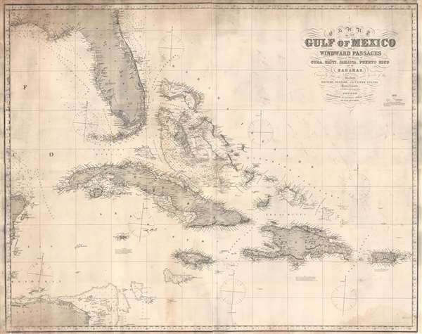
Chart of the Gulf of Mexico and Windward Passages Including the Islands of Cuba, Haïti, Jamaica, Puerto Rico, and the Bahamas.
sold
- Digital Map Information
- Suitable for large format printing
- Full resolution TIFF file
- ICC color profile embedded
- Delivered instantly via download link
This is an 1873 James Imray blueback nautical chart or maritime map of the Gulf of Mexico and the West Indies, including the Greater Antilles. The map depicts from Pensacola, Florida and the eastern tip of the Yucatan Peninsula to Puerto Rico and from Georgia to Honduras and the Mosquito Coast. Highly detailed, numerous depth soundings are included, particularly along the coast of the United States, the coast of Cuba, in the Bahamas. Locations throughout the region are labeled, mostly along the coastlines, but some inland locations are indicated on Cuba and Hispaniola. Havana, Pensacola, Cape Canaveral, St. Augustine, Port au Prince, and San Juan are among the locations labeled. Manuscript notations in the form of yellow dots mark the location of every lighthouse in the region from the Bay of Honduras and Pensacola to Puerto Rico. (more details)
Working Nauical Chart encompassing all of the Lesser Antilles, including the Virgin Island and St. Lucia.
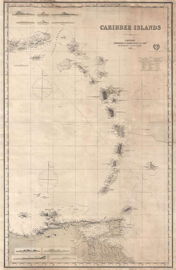
Caribbee Islands.
sold
- Digital Map Information
- Suitable for large format printing
- File Size: 17.42 MB
- File Type: ZIP / TIFF
- ICC color profile embedded
- Delivered instantly via download link
This is an 1873 James Imray blueback nautical chart or maritime map of the Lesser Antilles in the West Indies. The map depicts the region from the eastern portion of Puerto Rico to Barbados and from Puerto Rico to South America, including the Virgin Islands, Antigua and Barbuda, Montserrat, Martinique, Guadeloupe, Dominica, St. Lucia, St. Vincent and the Grenadines, and Trinidad and Tobago. Highly detailed, coastal locations are labeled on each of the islands and topography is illustrated on those islands that had been surveyed. Each island also bears the label of which colonial power controlled the island, whether it was France, Spain, the United Kingdom, the Netherlands, or Sweden. Depth soundings are included around the Virgin Islands, Anguilla, St. Martin, St. Bartholomew, Montserrat, Antigua and Barbuda, St. Eustatius, St. Christopher, Nevis, the Grenadines, and Trinidad and Tobago, as well as along the South American coast. Numerous locations along the coast of South America are also labeled, including the Orinoco River Delta and its mouth. Ten profile views of the islands are included along both the top and bottom border, including Guadeloupe, Martinique, Barbados, and St. Eustatius. Notes on the soundings and lines of longitude are situated along the right border, along with a note from the publishers stating that they 'request communications that may tend to the improvement of this, or any of their works'. (more details)
One of the first American maps to identify Singapore.

East Indies.
sold
- Digital Map Information
- Suitable for large format printing
- File Size: 7.83 MB
- File Type: ZIP / TIFF
- ICC color profile embedded
- Delivered instantly via download link
This is a beautiful full color first edition example of J. H. Colton's 1855 Colton map of the East Indies. The map depicts from Burma in the extreme northwest to New Guinea and East Timor in the southeast, which includes of burma, Pegu, Siam (Thailand), ... (more details)
A gorgeous full color example of the first edition of Colton's map of Washington. D.C.

Colton's Georgetown and the City of Washington The Capital of the United States of America.
sold
- Digital Map Information
- Suitable for large format printing
- File Size: 5.6 MB
- File Type: ZIP / TIFF
- ICC color profile embedded
- Delivered instantly via download link
This is an 1855 first edition of Colton's rare map of Washington D.C. and Georgetown in exceptionally rich full color. The map depicts the city in incredible detail from Georgetown (Georgetown University, then College, shown) on the upper left to ... (more details)
Cold War Era map illustrating Washington, D.C. evacuation routes in the event of a nuclear strike.

Washington Warning Area Map I.
sold
This is a 1959 Office of Civil and Defense Mobilization map of Washington, D.C created during the height of the Cold War. The map depicts the city from Falls Church and Springfield, Virginia to District Heights and Randolph Village, Maryland. ... (more details)
British India at the height of the Raj.

Johnson's Hindostan or British India
sold
- Digital Map Information
- Suitable for large format printing
- File Size: 6.29 MB
- File Type: ZIP / TIFF
- ICC color profile embedded
- Delivered instantly via download link
This is a very nice example of Johnson and Ward's 1863 map of India and Southeast Asia. It covers from the mouths of the Indus River eastward to include all of India, Burma, Siam (Thailand), Laos, Cambodia, Malaysia (Malacca) Singapore and ... (more details)
Both contemporary and ancient place names are given.

Johnson's Palestine.
sold
- Digital Map Information
- Suitable for large format printing
- File Size: 6.73 MB
- File Type: ZIP / TIFF
- ICC color profile embedded
- Delivered instantly via download link
This is a beautiful example of Johnson and Ward's 1863 map of Palestine, Israel or the Holy Land. It details the region from Beirut south to Busaireh and Kadesh Barnea and extends eastward as far as Mount Alsadamus in modern day Syria. ... (more details)
Includes the Austro-Hungarian Empire.

Johnson's Austria Turkey in Europe and Greece.
sold
- Digital Map Information
- Suitable for large format printing
- File Size: 15.66 MB
- File Type: ZIP / TIFF
- ICC color profile embedded
- Delivered instantly via download link
This is a beautiful example of Johnson and Ward's 1863 map of Austria, Turkey in Europe and Greece. The map depicts from Italy eastward to include all of Austria, Hungary, the Balkans (Bosnia, Serbia, Albania, Croatia, Macedonia, ... (more details)
Depicts these Southern states at the height of the Civil War.
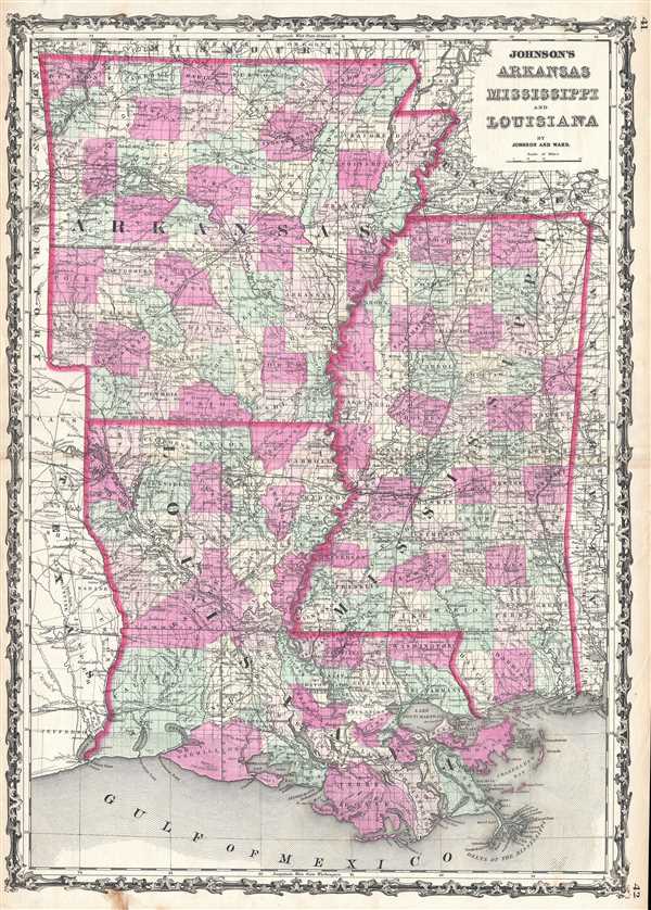
Johnson's Arkansas, Mississippi, And Louisiana.
sold
- Digital Map Information
- Suitable for large format printing
- File Size: 17.6 MB
- File Type: ZIP / TIFF
- ICC color profile embedded
- Delivered instantly via download link
This is a beautiful example of Johnson and Ward's 1863 map of Arkansas, Mississippi and Louisiana. This rare map offers a fascinating snapshot of these secessionist states during the American Civil War. The map depicts all three ... (more details)
The first Johnson map to depict a partitioned Virginia.

Johnson's Pennsylvania, Virginia, Delaware, and Maryland.
sold
- Digital Map Information
- Suitable for large format printing
- File Size: 17.41 MB
- File Type: ZIP / TIFF
- ICC color profile embedded
- Delivered instantly via download link
This is an 1863 Johnson and Ward map of Pennsylvania, Virginia, West Virginia, Delaware, and Maryland. The map depicts the region from Ohio and Kentucky to the Atlantic Ocean and from New York to North Carolina. This is the first ... (more details)
Unusual dual purpose map illustrating both American Indian lands and Quaker annual meetings.
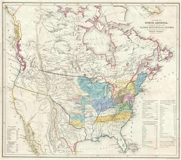
A Map of North America denoting the boundaries of the Yearly Meetings of Friends and the locations of the various Indian Tribes.
sold
- Digital Map Information
- Suitable for large format printing
- DPI: 300
- File Size: 9.25 MB
- File Type: ZIP / TIFF
- ICC color profile embedded
- Delivered instantly via download link
A fascinating 1844 map of the United States, the Republic of Texas, and Canada. This map was made for the annual Society of Friends (Quakers) Aborigines' Committee of the Meetings of Sufferings. This was an annual meeting ... (more details)
Rare Japanese national flag sample book predating WWII with controversial flags : 'Five Races Under One Union' flag of China, Nazi Swastika Flag, Manchukuo Flag.

[Hiraoka National Flag Sampe Book]
sold
This is a rare Japanese Pre-World War II era sample flag book published between 1937 and 1940. The sample book containing 25 national flags including Japan, Nazi Germany, Manchukuo, the Provisional Government of the ... (more details)
World War II Allied target map of Tsingtao. This map is unique and unlike any others we were able to locate.
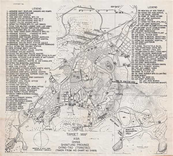
Target Map. Asia. China. Shantung Province. Ch'ing-Tap (Tsingtao).
sold
- Digital Map Information
- Suitable for large format printing
- File Size: 9.7 MB
- File Type: ZIP / TIFF
- ICC color profile embedded
- Delivered instantly via download link
This is a 'top-secret' or 'confidential' Allied 1944 map of Qingdao (Tsingtao), China, probably by the United States Army Air Forces, with potential bombing targets labeled throughout (Despite the fact that Tsingtao ... (more details)
Map illustrating the fading French Louisiana just before the Louisiana Purchase.
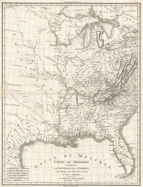
Cours Du Mississipi Comprenant La Louisiane, Les 2 Florides, Une Partie Des Etats-Unis, et Pays Adjacents.
sold
- Digital Map Information
- Suitable for large format printing
- DPI: 300
- File Size: 8.83 MB
- File Type: ZIP / TIFF
- ICC color profile embedded
- Delivered instantly via download link
A scarce 1803 map by Jean-Baptiste Poirson illustrating French Louisiana on the cusp of the Louisiana Purchase. Centered on the Mississippi River Valley, the map extends from the Great Lakes to the Gulf of Mexico, ... (more details)
Incredile pictorial map recounting Montana's frontier history.

Montana. Frontier. Pioneer.
sold
- Digital Map Information
- Suitable for large format printing
- File Size: 10.36 MB
- File Type: ZIP / TIFF
- ICC color profile embedded
- Delivered instantly via download link
This is a 1937 Irvin Shope pictorial map of Montana. The map depicts the state from Idaho to the Dakotas and from Canada to Wyoming, including Yellowstone National Park. Highly detailed, myriad captions, ... (more details)
A charming pictorial map of Greenwich Village - labels New York University and the Whitney Museum.
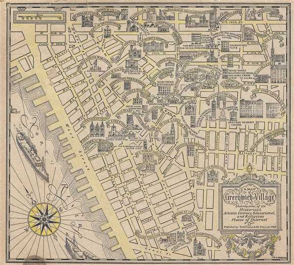
A Map of Greenwich Village Showing some of its Historical, Artistic, Literary, Educational, and Religious Places of Interest.
sold
- Digital Map Information
- Suitable for large format printing
- File Size: 3.7 MB
- File Type: ZIP / TIFF
- ICC color profile embedded
- Delivered instantly via download link
This is a 1934 E. L. Harper pictorial map of Greenwich Village. The map depicts this New York City neighborhood from the North (Hudson) River to Lafayette Street and from East 14th Street to Canal ... (more details)
Map illustrating the Bordeaux Wine Region and neighboring Armagnac Region.

Le Gouvernement General de Guienne et Gascogne.
sold
- Digital Map Information
- Suitable for large format printing
- DPI: 300
- File Size: 17.11 MB
- File Type: ZIP / TIFF
- ICC color profile embedded
- Delivered instantly via download link
This is a fascinating 1742 map of the modern French departments of Gironde, Gascony (Gascogne), and Guyenne. This coastal region is the seat of the Bordeaux wine region and produces many of the ... (more details)