
Illustrates five different spheres used in cartography.

Sphère de Ptolomée.
sold
- Digital Map Information
- Suitable for large format printing
- DPI: 300
- File Size: 4.14 MB
- File Type: ZIP / TIFF
- ICC color profile embedded
- Delivered instantly via download link
This is Rigobert Bonne's 1775 curious decorative chart of the Spheres. The chart features five different spheres used in mapmaking and calculating map projections. From top left, Sphère de Ptolomée (Ptolemaic Sphere), Sphère Droite (Right Sphere), Sphère ... (more details)
Important early map of New Orleans.
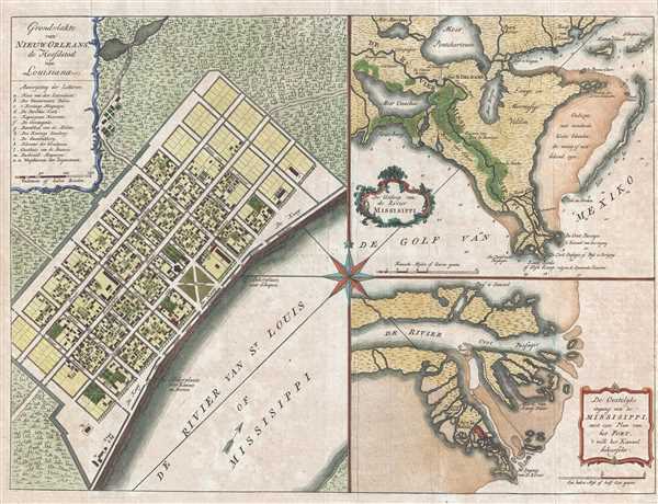
Grondvlakte van Nieuw Orleans, de hoofdstad van Louisiana. / De uitloop van de Rivier Missisippi. / De oostelyke ingang van de Missisippi, met een plan van het fort, 't welk het kanaal beheerscht.
sold
- Digital Map Information
- Suitable for large format printing
- DPI: 300
- File Size: 7.06 MB
- File Type: ZIP / TIFF
- ICC color profile embedded
- Delivered instantly via download link
A fine example of one of the more beautiful 18th century maps of New Orleans and the Mississippi River Delta. This map, issued in 1769 by Isaak Tirion, is essentially three related maps on a single sheet. The primary map, occupying the left quadrants, is a ... (more details)
Labels numerous cities, towns, and missions throughout the region.
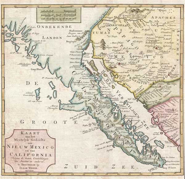
Kaart van het Westelyk Gedeelte van Nieuw Mexico en van California Volgens de Laatste Ontdekkingen der Jesuiten en Anderen.
sold
- Digital Map Information
- Suitable for large format printing
- DPI: 300
- File Size: 4.39 MB
- File Type: ZIP / TIFF
- ICC color profile embedded
- Delivered instantly via download link
A scarce and important 1765 map detailing the Spanish/Mexican borderlands in the California-New Mexico (including modern-day Arizona) region. Despite its title, this map does not cover New Mexico, instead, it focuses on the Gulf of California, Baja ... (more details)
Features an interesting pre-Republic mapping of Texas folded into the Intendency of San Louis Potosi.

Mexico.
sold
- Digital Map Information
- Suitable for large format printing
- DPI: 300
- File Size: 2.39 MB
- File Type: ZIP / TIFF
- ICC color profile embedded
- Delivered instantly via download link
This is a scarce and important 1828 map of Mexico by Anthony Finley. The map depicts from upper California and New Albion south to Guatemala, including the modern-day regions of California, New Mexico, Arizona, Colorado, Utah, Nevada, Texas and ... (more details)
Illustrates the apocryphal Laguna de Xarayes.
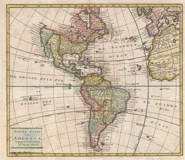
Nieuwe Kaart van America.
sold
- Digital Map Information
- Suitable for large format printing
- DPI: 300
- File Size: 4.98 MB
- File Type: ZIP / TIFF
- ICC color profile embedded
- Delivered instantly via download link
This is a c. 1769 Isaak Tirion map of the Americas. The map depicts from the Pacific Ocean to Europe, the British Isles, and West Africa and from Hudson Bay to Tierra del Fuego. Regions throughout the Americas are labeled, including some of the ... (more details)
Beautiful view created during the Second Spanish period in Pensacola's history.
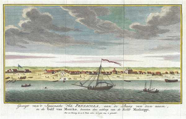
Gezigt van't Spaansche Vlek Pensacoa, aan de Baay van diennaam, in de Golf van Mexiko, beoosten den uitloop van de Rivier Missisippi. Naar een Tekening, die op de Plaats zebre, in it jaar 1743, is gemaakt.
sold
- Digital Map Information
- Suitable for large format printing
- DPI: 300
- File Size: 2.17 MB
- File Type: ZIP / TIFF
- ICC color profile embedded
- Delivered instantly via download link
This is a 1743 Isaak Tirion view of Pensacola, Florida. This incredibly attractive view most likely depicts the settlement from Pensacola Bay. Numerous churches, houses, and other buildings are illustrated, along with a sailing ship and several ... (more details)
Depicts land assigned to the Sac and Fox, Winnebago, and Ottowa Nations before they were forcibly removed to the Indian Territory.
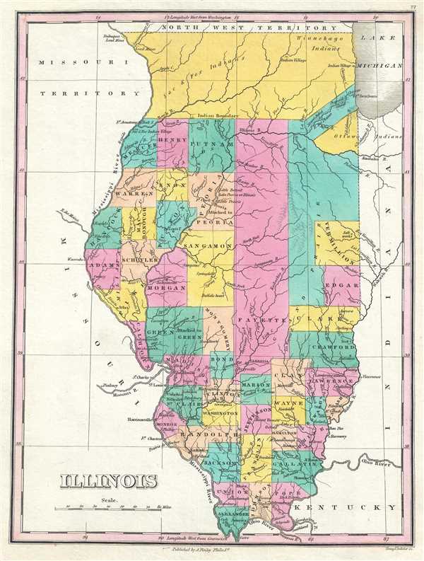
Illinois.
sold
- Digital Map Information
- Suitable for large format printing
- DPI: 300
- File Size: 2.26 MB
- File Type: ZIP / TIFF
- ICC color profile embedded
- Delivered instantly via download link
This is an 1828 Anthony Finley map of Illinois. The map depicts the state and the region from the Northwest Territory to Kentucky and from the Missouri Territory to Indiana in Finley's classic minimalist style. Rivers, roads, canals, and some ... (more details)
Depicts land assigned to the Delaware, Miami, Kickapoo, Ottaway, and Pottawatomie Nations before they were forcibly removed to the Indian Territory.

Indiana.
sold
- Digital Map Information
- Suitable for large format printing
- DPI: 300
- File Size: 2.33 MB
- File Type: ZIP / TIFF
- ICC color profile embedded
- Delivered instantly via download link
This is an 1828 Anthony Finley map of Indiana. The map depicts the state and the region from the Michigan Territory and Lake Michigan to Kentucky and from Illinois to Ohio in Finley's classic minimalist style. Rivers, roads, canals, and some ... (more details)
One of the earliest obtainable maps of the State of Missouri.
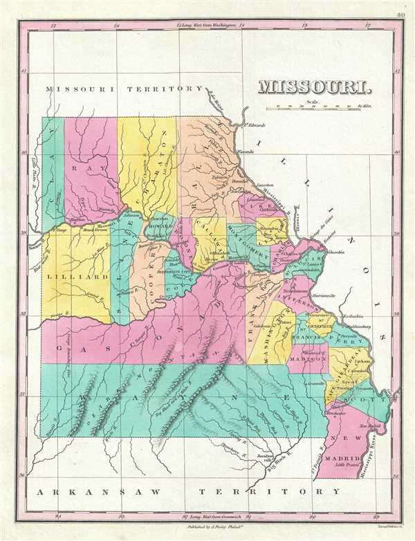
Missouri.
sold
- Digital Map Information
- Suitable for large format printing
- DPI: 300
- File Size: 2.29 MB
- File Type: ZIP / TIFF
- ICC color profile embedded
- Delivered instantly via download link
This is an 1828 Anthony Finley map of Missouri shortly following statehood. This is one of the earliest obtainable maps of the State of Missouri. The map depicts the newly created state from the Missouri Terrotory to the Arkansas ... (more details)
Depicts land assigned to the Chickasaw and Choctaw Nations prior to the Trail of Tears.

Mississippi.
sold
- Digital Map Information
- Suitable for large format printing
- DPI: 300
- File Size: 2.47 MB
- File Type: ZIP / TIFF
- ICC color profile embedded
- Delivered instantly via download link
This is an 1828 Anthony Finley map of Mississippi. The map depicts the state and the region from Louisiana and Arkansas to Alabama and from Tennessee and Arkansas to Louisiana, Lake Pontchartrain, Mobile Bay, and the Gulf of Mexico ... (more details)
Labels 'Guanaham' or 'Cat Isle,' the first land sighted by Columbus in the Americas.

West Indies.
sold
- Digital Map Information
- Suitable for large format printing
- DPI: 300
- File Size: 3.13 MB
- File Type: ZIP / TIFF
- ICC color profile embedded
- Delivered instantly via download link
This is an 1828 Anthony Finley map of the West Indies and Caribbean. The map depicts the Greater and Lesser Antilles as well as the Bahamas and portions of the Spanish Main from southern Florida to Colombia and from Cuba and ... (more details)
Ilustrates Cherokee territory in southeastern Tennessee prior to the Trail of Tears.

Tennessee.
sold
- Digital Map Information
- Suitable for large format printing
- DPI: 300
- File Size: 2.2 MB
- File Type: ZIP / TIFF
- ICC color profile embedded
- Delivered instantly via download link
This is an 1828 Anthony Finley map of Tennessee. The map depicts the state and the region from Kentucky to Mississippi, Alabama, and Georgia and from the Mississippi River to North Carolina in Finley's classic minimalist ... (more details)
Brilliant regional and county map of Ireland.

Ireland.
sold
- Digital Map Information
- Suitable for large format printing
- DPI: 300
- File Size: 2.82 MB
- File Type: ZIP / TIFF
- ICC color profile embedded
- Delivered instantly via download link
This is an 1828 Anthony Finley map of Ireland. The map depicts Ireland from the Atlantic Ocean to the Irish Sea and from the North Channel to St. George's Channel. Rivers, roads, canals, and some topographical features ... (more details)
Predates Italian Unification - depicts the Papal States.

Italy.
sold
- Digital Map Information
- Suitable for large format printing
- DPI: 300
- File Size: 2.86 MB
- File Type: ZIP / TIFF
- ICC color profile embedded
- Delivered instantly via download link
This is an 1828 Anthony Finley map of Italy. The map depicts the Italian peninsula from Austria and Switzerland to Sicily and Malta. The Islands of Sardinia and Corsica are included, as well as Dalmatia across the ... (more details)
Created during the Greek War for Independence from the Ottoman Empire.

Greece.
sold
- Digital Map Information
- Suitable for large format printing
- DPI: 300
- File Size: 2.79 MB
- File Type: ZIP / TIFF
- ICC color profile embedded
- Delivered instantly via download link
This is a beautiful 1828 Anthony Finley's map of Greece. The map depicts the region from Macedonia to the island of Candia and from the Ionian Sea to Asia Minor, and includes many of the Cyclades. Numerous ... (more details)
Prussia as it was under King Friedrich Wilhelm III.

Prussia.
sold
- Digital Map Information
- Suitable for large format printing
- DPI: 300
- File Size: 2.69 MB
- File Type: ZIP / TIFF
- ICC color profile embedded
- Delivered instantly via download link
This is an 1828 Anthony Finley map of Prussia. The map depicts from the Baltic Sea to Saxony and Austria and from Hanover to Russia, detailing the Kingdom of Prussia, the most powerful state of the Germanic ... (more details)
An example of an early edition of one of the most celebrated maps of London.
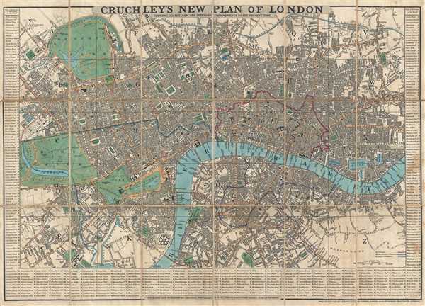
Cruchley's New Plan of London. Shewing All the New and Intended Improvements to the Present Time.
sold
- Digital Map Information
- Suitable for large format printing
- DPI: 300
- File Size: 14.97 MB
- File Type: ZIP / TIFF
- ICC color profile embedded
- Delivered instantly via download link
This is an 1834 edition of George Frederick Cruchley's famous city map or plan of London, England. The map depicts the city from Hyde Park to the London Docks and from Regent's Park and the Regents Canal to ... (more details)
Showing Creek and Cherokee territory prior to the Trail of Tears.
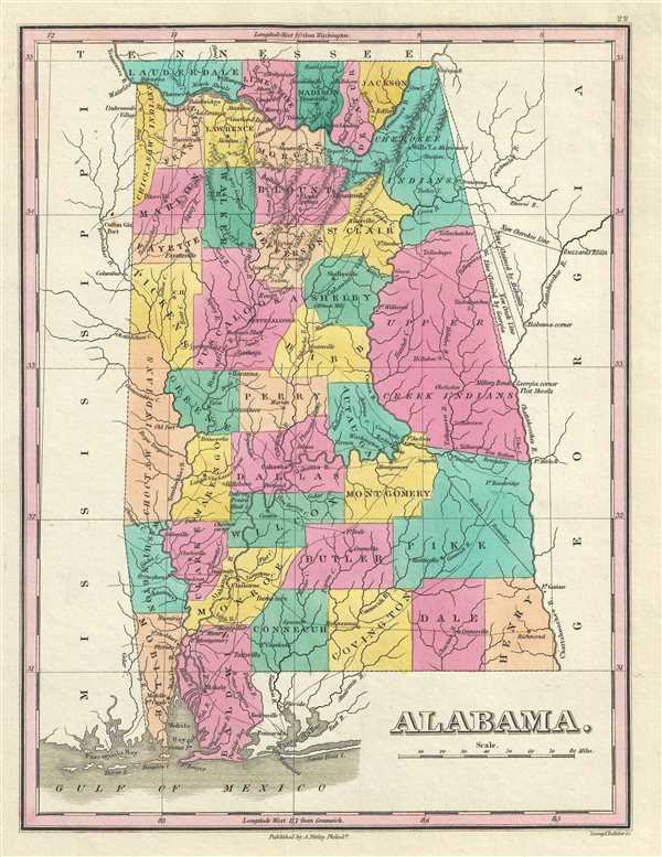
Alabama.
sold
- Digital Map Information
- Suitable for large format printing
- DPI: 300
- File Size: 2.78 MB
- File Type: ZIP / TIFF
- ICC color profile embedded
- Delivered instantly via download link
This is an 1828 Anthony Finley map of Alabama. The map depicts the state from Tennessee to the Gulf of Mexico and from Mississippi to Georgia in Finley's classic minimalist style. Rivers, roads, canals, ... (more details)
Showing Creek and Cherokee territory prior to the Trail of Tears.
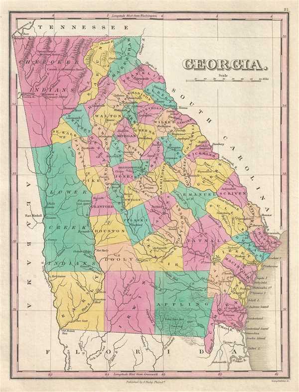
Georgia.
sold
- Digital Map Information
- Suitable for large format printing
- DPI: 300
- File Size: 2.68 MB
- File Type: ZIP / TIFF
- ICC color profile embedded
- Delivered instantly via download link
This is an 1828 Anthony Finley map of Georgia. The map depicts the state from Tennessee to Florida and from Alabama to South Carolina and the Atlantic Ocean in Finley's classic minimalist style. ... (more details)
Depicts North Carolina exclusively - usually both North and South Carolina are depicted.

North Carolina.
sold
- Digital Map Information
- Suitable for large format printing
- DPI: 300
- File Size: 2.41 MB
- File Type: ZIP / TIFF
- ICC color profile embedded
- Delivered instantly via download link
This is an 1828 Anthony Finley map of North Carolina. This rare map plate configuration depicts the state individually rather than bundled with South Carolina - as is more common. The region is ... (more details)