
Map of Korea drawn just after the Japan–Korea Annexation Treaty.

朝鮮全圖 / Map of Korea.
sold
- Digital Map Information
- Suitable for large format printing
- File Size: 12.11 MB
- File Type: ZIP / TIFF
- ICC color profile embedded
- Delivered instantly via download link
This uncommon 1910 map of Korea was issued following the Japan–Korea Annexation Treaty, the agreement that formally annexed Korea as part of Japan. The map covers all of Korea, including modern day North Korea and South Korea. This 1910 annexation began what is ... (more details)
Illustrates North America and Greenland as one large continent.
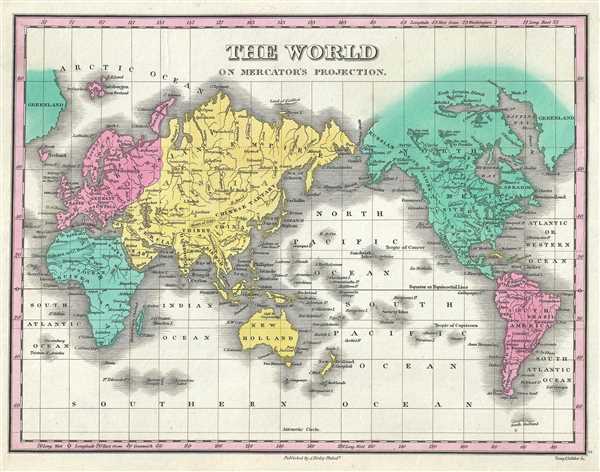
The World on Mercator's Projection.
sold
- Digital Map Information
- Suitable for large format printing
- DPI: 300
- File Size: 2.56 MB
- File Type: ZIP / TIFF
- ICC color profile embedded
- Delivered instantly via download link
This is an 1828 Anthony Finley map of the World. The map depicts the world on a Mercator Projection. Numerous countries and several cities are identified, although no national boundaries are illustrated. In all, more cities are labeled than countries. Myriad ... (more details)
Includes inset maps of the Bordeaux and Bourgogne wine regions.
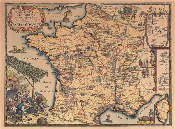
Fromaiges et Vignobles.
sold
- Digital Map Information
- Suitable for large format printing
- File Size: 13.98 MB
- File Type: ZIP / TIFF
- ICC color profile embedded
- Delivered instantly via download link
This is a 1963 Daniel-Louis Derveaux map of France, illustrating French wine and cheese producers. The map depicts the region from the English Channel and Belgium and Luxembourg to the Mediterranean Sea and from the Bay of Biscay to Germany, Switzerland, and ... (more details)
Labels numerous world capitals.

Eastern Hemisphere.
sold
- Digital Map Information
- Suitable for large format printing
- DPI: 300
- File Size: 2.3 MB
- File Type: ZIP / TIFF
- ICC color profile embedded
- Delivered instantly via download link
This is an 1828 Anthony Finley map of the Eastern Hemisphere. The map depicts the hemisphere from the eastern Atlantic Ocean across Africa and Europe to Asia and Australia and from the North Pole to the South Pole. Deserts, rivers, mountain ranges, lakes, ... (more details)
Champlain's great lost map of 1616 hidden within a Duval Map of 1664! The first printed map showing Lake Ontario and Lake Huron!
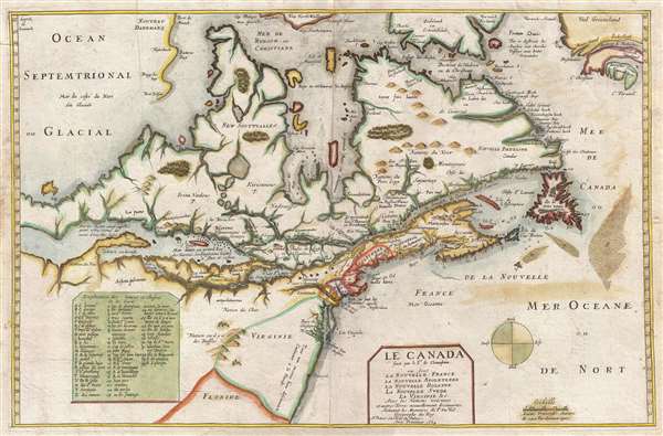
Le Canada faict par le Sr. de Champlain ou son La Nouelle France, La Nouvelle Angleterre, La Nouvelle Hollande, La Nouvelle Svede, La Virginie…
sold
- Digital Map Information
- Suitable for large format printing
- DPI: 300
- File Size: 9.35 MB
- File Type: ZIP / TIFF
- ICC color profile embedded
- Delivered instantly via download link
Truly one of the most intriguing maps we have had the privilege of working with. Ostensibly, this is the second edition of Pierre Du Val's map, Le Canada , but hidden within this map is one of the great historic maps – Samuel de Champlain's unpublished ... (more details)
Illustrates the historic flight of Valery Chkalov over the North Pole, pioneering the Polar Route!
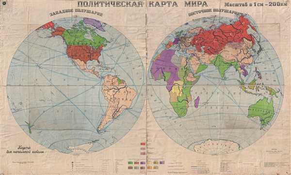
A Political Map of the World (ПОЛИТИЧЕСКАЯ КАРТА МИРА)
sold
- Digital Map Information
- Suitable for large format printing
- File Size: 60.81 MB
- File Type: ZIP / TIFF
- ICC color profile embedded
- Delivered instantly via download link
This is a 1938 Council of People's Commissars world map in two hemispheres. With the Western Hemisphere on the left and the Eastern Hemisphere on the right, the map depicts the world from the coast of Kamchatka and the Central Pacific Ocean across North ... (more details)
The only Civil War Era wall map of the United States issued by the U.S. Government.

The Washington Map of the United States.
sold
This is the 1861 second edition of Matthew Fontaine Maury’s important wall map of the United States, published by simultaneously by Joseph Taintor of Philadelphia and Holmes Harrison of London. This map covers the entirety of the United States as ... (more details)
Dutch version of the most popular caricature of Napoleon Bonaparte - denouncing his villiany!

Eigenaardige Afbeelding des geweldenaars.
sold
- Digital Map Information
- Suitable for large format printing
- DPI: 300
- File Size: 0.48 MB
- File Type: ZIP / TIFF
- ICC color profile embedded
- Delivered instantly via download link
This is an 1814 Evert Maaskamp caricature of Napoleon and political broadside attacking the violence and death perpetrated by the power-hungry despot. The caricature is based upon a portrait sketched by a Hanoverian artist named Heinrich Anton ... (more details)
World War II Era Japanese map illustrating Japanese intention to add Hawaii to its Empire!

標準大東亞分圖 : ハワイ誻島 / Standard Map of the Great East Co-Prosperity Sphere. Hawaiian Islands.
sold
- Digital Map Information
- Suitable for large format printing
- File Size: 11.05 MB
- File Type: ZIP / TIFF
- ICC color profile embedded
- Delivered instantly via download link
This is a rare 1943 Showa 18 map Japanese World War II (WWII) map of Hawaii from the Greater East Asian Co-Prosperity Sphere series. The map details the major Hawaiian Islands with an inset of Honolulu and Pearl Harbor, and other detailing ... (more details)
Includes charming vignettes of trains entering and leaving the city.

Plan de Paris en 1864 Divisé en 20 Arrondissements.
sold
- Digital Map Information
- Suitable for large format printing
- File Size: 23.57 MB
- File Type: ZIP / TIFF
- ICC color profile embedded
- Delivered instantly via download link
This is an 1864 J. N. Henriot city map or plan of Paris France. The map depicts the city from the Basilica of St. Denis (Abbaye de St. Denis) to the Fort de Bicêtre and from the Bois de Boulogne to the Fort de Nogent and the Fot de Rosny. ... (more details)
Depicts the region surrounding Beijing including roads and railroads.

Nearer Vicinity of Peking.
sold
- Digital Map Information
- Suitable for large format printing
- File Size: 2.61 MB
- File Type: ZIP / TIFF
- ICC color profile embedded
- Delivered instantly via download link
This is a 1924 Fei-Shi map of the vicinity around Beijing / Peking, China. The map depicts the region from Nankow and Nankou Pass (Juyong Pass) to Fang-Shan Hsien and Ta-Hsing. Forty-five locations around the map are numerically ... (more details)
Incredibly detailed city map of Beijing during the Interwar Period - identifies over 200 locations!

Plan of Peking Inside its Walls.
sold
- Digital Map Information
- Suitable for large format printing
- File Size: 8.7 MB
- File Type: ZIP / TIFF
- ICC color profile embedded
- Delivered instantly via download link
This is a 1924 Fei-Shi city map or plan of Beijing / Peking, China. The map depicts the city in great detail, numerically identifying over 210 locations throughout the city. The Tartar City, Chinese City, Legation Quarter, ... (more details)
Wonderful and rare pictorial map of Cape Ann, Massachusetts.

A Salty Map of Cape Ann.
sold
- Digital Map Information
- Suitable for large format printing
- File Size: 20.11 MB
- File Type: ZIP / TIFF
- ICC color profile embedded
- Delivered instantly via download link
A scarce and unusual map, this is a 1947 Larry O'Toole pictorial map of Cape Ann, Massachusetts. Cape Ann is in northeastern Massachusetts, about 30 miles from Boston. Cape Ann marks the northern limit of Massachusetts ... (more details)
Represents the culmination of the work conducted by the U.S. Coast Survey around Cape Fear.

Preliminary Chart of Frying Pan Shoals and Entrances to Cape Fear River North Carolina.
sold
- Digital Map Information
- Suitable for large format printing
- File Size: 17.79 MB
- File Type: ZIP / TIFF
- ICC color profile embedded
- Delivered instantly via download link
This is an 1857 U.S. Coast Survey nautical chart or maritime map of Cape Fear, North Carolina. One of the largest and most striking U.S.C.S. maps of the region, it depicts from Federal Point south to the top of Cape ... (more details)
Detailed chart of the Massachusetts coast between Ipswich and Annisquam.

Ipswich and Annisquam Harbors Massachusetts.
sold
- Digital Map Information
- Suitable for large format printing
- File Size: 15.9 MB
- File Type: ZIP / TIFF
- ICC color profile embedded
- Delivered instantly via download link
This is an 1857 U.S. Coast Survey nautical chart or maritime map of Ipswich and Annisquam Harbors, Massachusetts. The map depicts the region from the Ipswich River and Plum Island to the Essex River and Dogtown and ... (more details)
Important Texas coast chart detailing the Matagorda ay Lavaca Bay area.

Preliminary Chart of the Entrance to Matagorda Bay, Texas. / Sub-Sketch Part of Matagorda and Lavaca Bays. / Sub-Sketch Part of Lavaca Bay.
sold
- Digital Map Information
- Suitable for large format printing
- File Size: 10.45 MB
- File Type: ZIP / TIFF
- ICC color profile embedded
- Delivered instantly via download link
This is an uncommon 1857 U.S. Coast Survey nautical chart or maritime map of Matagorda Bay and Lavaca Bay in Texas. This sheet depicts three different sections of the Texas coast. The primary map, occupying the ... (more details)
Includes a detailed depiction of Nantucket and Vineyard Sounds.

Preliminary Chart No. 4 of the Sea Coast of the United States from Plymouth Mass. To Saughkonnet River R. I.
sold
- Digital Map Information
- Suitable for large format printing
- File Size: 16.83 MB
- File Type: ZIP / TIFF
- ICC color profile embedded
- Delivered instantly via download link
This is an 1857 United States Coast Survey nautical chart or maritime map of the Massachusetts coast. The map depicts from Plymouth, Massachusetts to Saughkonnet River, Rhode Island. Barnstable County, Cape ... (more details)
One of the earliest American nautical charts to specifically detail this region.

St. Helena Sound South Carolina.
sold
- Digital Map Information
- Suitable for large format printing
- File Size: 13.58 MB
- File Type: ZIP / TIFF
- ICC color profile embedded
- Delivered instantly via download link
This is an 1857 U.S. Coast Survey nautical chart or maritime map of St. Helena Sound, South Carolina. The map depicts from the Edisto Islands south past Morgan Island and St. Helena Island to Fripp's ... (more details)
Early U.S. Coast Survey map of New Jersey.

Sketch B. No. 3 Showing the Triangulation and Geographical Positions in Section no. II From New York City to Cape Henlopen.
sold
- Digital Map Information
- Suitable for large format printing
- DPI: 300
- File Size: 10.39 MB
- File Type: ZIP / TIFF
- ICC color profile embedded
- Delivered instantly via download link
This is an exceptional example of the 1851 U.S. Coast Survey's nautical chart or maritime map for New Jersey and the Delaware Bay. It covers the coast line from New York City south through New Jersey ... (more details)
An early nautical chart of New York Harbor - labels Manhattan and Brooklyn!
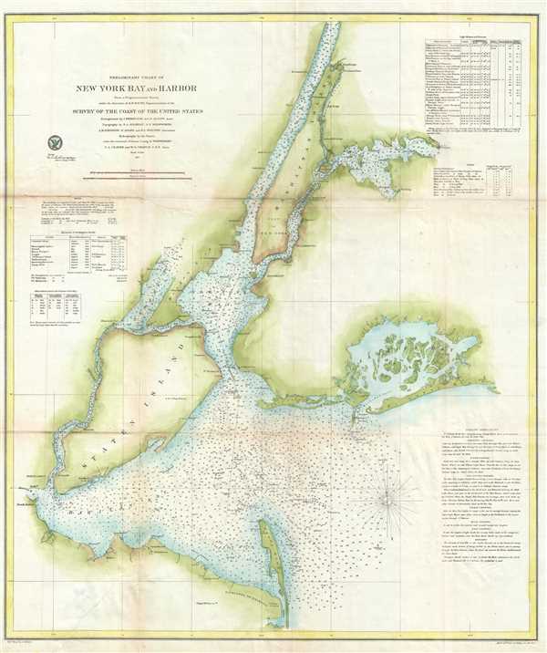
Preliminary Chart of New York Bay and Harbor.
sold
- Digital Map Information
- Suitable for large format printing
- File Size: 13.65 MB
- File Type: ZIP / TIFF
- ICC color profile embedded
- Delivered instantly via download link
This is a rare 1857 U.S. Coast Survey nautical chart or maritime map of New York City, it's harbor, and environs. One of the first 19th century charts to depict New York City as we know it today, it ... (more details)