
Exceptional Beaufort Harbor, North Carolina.

Beaufort Harbor North Carolina.
sold
- Digital Map Information
- Suitable for large format printing
- File Size: 21.14 MB
- File Type: ZIP / TIFF
- ICC color profile embedded
- Delivered instantly via download link
This is a scarce hand-colored 1857 U.S.C.S. maritime map or nautical chart of Beaufort Harbor, North Carolina. The chart depicts the North Carolina coast from Carolina City westward through Beaufort as far as Lenoxville Point. It features superb inland detail of ... (more details)
Educational WPA Poster Map by the modernist Cleveland artist Fren Rentschler.
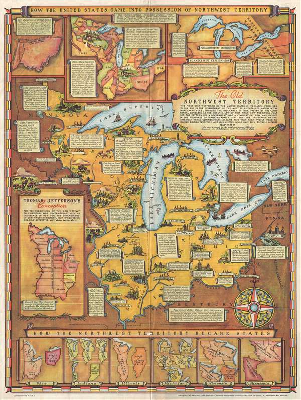
The Old Northwest Territory.
sold
- Digital Map Information
- Suitable for large format printing
- File Size: 13.85 MB
- File Type: ZIP / TIFF
- ICC color profile embedded
- Delivered instantly via download link
An uncommon 1937 pictorial map of the old Northwest Territory by Fred Rentschler. The map includes all five of the great lakes and focuses on the modern-day states of Minnesota, Wisconsin, Illinois, Indiana, Michigan, and Ohio. It includes numerous vignette ... (more details)
An exceptionally detailed map of New York City just after the Civil War.
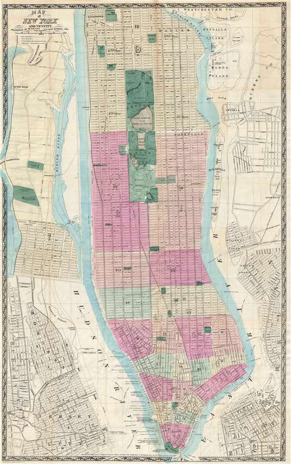
Map of New York and Vicinity.
sold
- Digital Map Information
- Suitable for large format printing
- File Size: 14.94 MB
- File Type: ZIP / TIFF
- ICC color profile embedded
- Delivered instantly via download link
This is a scarce large format 1865 map or plan of New York City by Matthew Dripps. It covers the entire island of Manhattan as well as parts of Brooklyn, Queens, Hoboken and Jersey City. The map shows the city in considerable detail with all streets and, in ... (more details)
Extremely rare map of Australia during the 1851 Gold Rush.
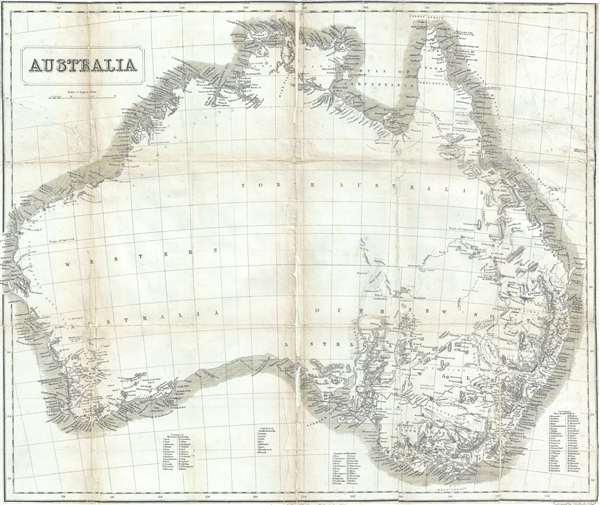
Australia.
sold
- Digital Map Information
- Suitable for large format printing
- DPI: 300
- File Size: 9.3 MB
- File Type: ZIP / TIFF
- ICC color profile embedded
- Delivered instantly via download link
A remarkable 1853 John Capper Map of Australia issued to promote the 1851 Victoria Gold Rush. Capper's map covers the entire continent and offers a wealth of interesting annotations. On the western side of the continent, for example there is annotation that ... (more details)
A beautifully craftied pictorial tourist map of Rome, Italy, illustrating the birth of the Roman Tram System.

Pianta Guida della Citta di Roma : Veduta a volo d'uccello.
sold
- Digital Map Information
- Suitable for large format printing
- File Size: 17.46 MB
- File Type: ZIP / TIFF
- ICC color profile embedded
- Delivered instantly via download link
This is an 1885 Romolo Bulla tourist map of Rome, Italy. Oriented to the west-southwest, Bulla's map shows from the Aventine Hill, on the left, to the Piazza del Popolo and the Villa Borghese, on the right, and from the Vatican at the top of the map to the ... (more details)
Map of the Napa River and the Mare Island Straits, California.

Mare Island Straits California.
sold
- Digital Map Information
- Suitable for large format printing
- File Size: 7.48 MB
- File Type: ZIP / TIFF
- ICC color profile embedded
- Delivered instantly via download link
This is a lovely hand colored example of the 1857 U.S. Coast Survey nautical chart or maritime map of the Napa River and the Mare Island Straits, California. The map covers part of the San Francisco Bay area including Mare Island, Straits of Karquines and ... (more details)
A visually striking map of Geneva, Switzerland.
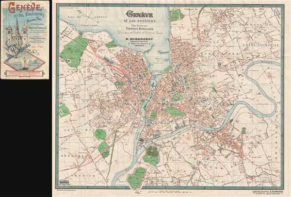
Genève et ses environs.
sold
- Digital Map Information
- Suitable for large format printing
- File Size: 13.44 MB
- File Type: ZIP / TIFF
- ICC color profile embedded
- Delivered instantly via download link
This is a beautifully colored 1900 Charles Bobillier city map of Geneva, Switzerland. This map illustrates the city of Geneva in detail, labeling all the major streets and bridges, and the surrounding area. The parks and gardens are also labeled. The ... (more details)
Sir Clements Robert Markham remarkable reconnaissance of the Helmand River in Afghanistan.
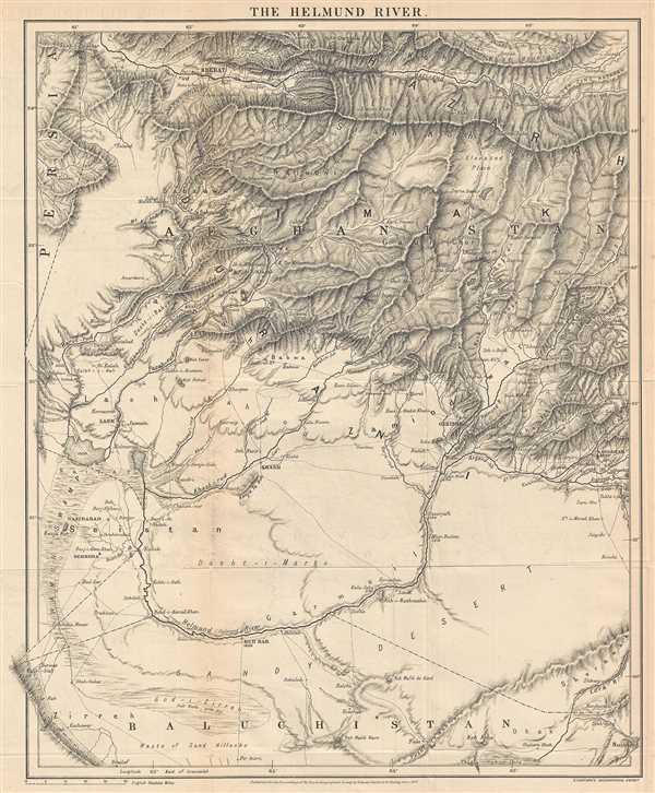
The Helmund River.
sold
- Digital Map Information
- Suitable for large format printing
- File Size: 6.65 MB
- File Type: ZIP / TIFF
- ICC color profile embedded
- Delivered instantly via download link
This is a rare 1879 Sir Clements Robert Markham map of Afghanistan and Pakistan. This map illustrates southwestern Afghanistan and northwestern Pakistan (Baluchistan) and parts of extreme eastern Iran (Persia), including the Hindu Kush (Koh-i-Baba), ... (more details)
Rare map of Turkmenistan and Iran illustrating Sir Rawlinson's reconnaissance of the Russian invasion of Central Asia.
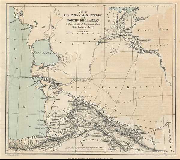
Map of the Turcoman Steppe and Northern Khorassan to illustrate Sir H. Rawlinson's paper 'The Road to Merv'
sold
- Digital Map Information
- Suitable for large format printing
- File Size: 1.71 MB
- File Type: ZIP / TIFF
- ICC color profile embedded
- Delivered instantly via download link
This is a rare 1879 Sir Henry Rawlinson map of Turkmenistan and Iran. The map shows from the eastern Caspian Sea to the western half of Turkmenistan, which the map calls the Turcoman Steppe and from the Aral Sea to the northern reaches of Iran ... (more details)
A splendid and highly graphic pictorial map of Paris and its monuments.

Paris Monumental et Métropolitain.
sold
- Digital Map Information
- Suitable for large format printing
- Full resolution TIFF file
- ICC color profile embedded
- Delivered instantly via download link
This extremely appealing c. 1920 pocket map of Paris France by Robelin, combines the virtues of a map and a view. Designed with the tourist in mind, this map covers the embastilled center of Paris and its immediate vicinity. It reflects the ... (more details)
One of the earliest accurate nautical charts of St. Louis Bay, Mississippi.

St. Louis Bay and Shieldsboro Harbor Mississippi.
sold
- Digital Map Information
- Suitable for large format printing
- File Size: 8.63 MB
- File Type: ZIP / TIFF
- ICC color profile embedded
- Delivered instantly via download link
An attractive hand colored 1857 U.S. Coast Survey triangulation chart or map of St. Louis Bay, Mississippi. The chart details the area around St. Louis Bay including the town of Shieldsboro (modern St. Louis Bay) and Pass Christian, ... (more details)
One of the earliest accurate nautical charts of Entrance to York River, Virginia.

Preliminary Chart of York River Virginia from Entrance to King's Creek.
sold
- Digital Map Information
- Suitable for large format printing
- File Size: 10.63 MB
- File Type: ZIP / TIFF
- ICC color profile embedded
- Delivered instantly via download link
An attractive hand colored 1857 U.S. Coast Survey nautical chart or map of Virginia's York River. The chart covers the course of the York River from its entrance at Chesapeake Bay to King's Creek. It offers countless depth ... (more details)
Extremely attractive and detailed large early American map of the Philippines.
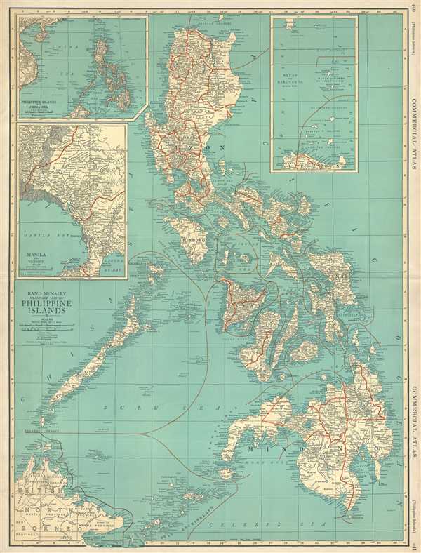
Rand McNally Standard Map of Philippine Islands
sold
- Digital Map Information
- Suitable for large format printing
- File Size: 9.82 MB
- File Type: ZIP / TIFF
- ICC color profile embedded
- Delivered instantly via download link
This is a 1924 Rand McNally map of the Philippines. This map illustrates the entire Philippine archipelago and labels all the major islands, including Luzon, Leyte, Panay, Samar, and Mindanao. The map also includes British ... (more details)
A rare and incredible view of the port and city of Le Havre, France.

Panorama du Port et de la Ville du Hâvre.
sold
- Digital Map Information
- Suitable for large format printing
- File Size: 8.56 MB
- File Type: ZIP / TIFF
- ICC color profile embedded
- Delivered instantly via download link
This is a visually striking 1868 Léon Auguste Asselineau view of the port and city of Le Havre, France. This panorama reveals the port of Le Havre on a windy day with rough seas. There are ships of several different types ... (more details)
Triangulation chart of Florida's northwest coast.
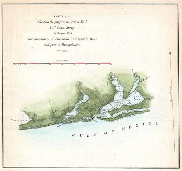
Sketch C Showing the progress in Section No. 7. Reconnoissance of Pensacola and Perdido Bays and plan of Triangulation.
sold
- Digital Map Information
- Suitable for large format printing
- DPI: 300
- File Size: 0.91 MB
- File Type: ZIP / TIFF
- ICC color profile embedded
- Delivered instantly via download link
A lovely example of the 1849 U.S. Coast Survey progress and triangulation chart or map of the Gulf Coast of northwest Florida from Pensacola Bay and Santa Rosa Sound west to Bon Secour Bay in Alabama. Includes Perdido Bay. ... (more details)
Interesting map depicting the distribution of the world's animals, industry and ocean currents.

Johnson's Map of The World Showing the Geographical Distribution and Range of The Principal Members of The Animal Kingdom. Johnson's Map of The World Illustrating the Productive Industry and exhibiting the principal features of Commerce And Navigation. Johnson's Map Showing the Principal Ocean Currents and Boundaries of the River Systems.
sold
- Digital Map Information
- Suitable for large format printing
- File Size: 6.02 MB
- File Type: ZIP / TIFF
- ICC color profile embedded
- Delivered instantly via download link
This is one of the thematic world map sets from the rare 1864 edition of Johnson and Ward's New Illustrated Atlas . It features three maps within a single border. The first map depicts the geographical distribution and ... (more details)
Triangulation chart of Rappahannock River, Virginia.

Preliminary Chart of Rappahannock River Virginia from Occupacia Creek to Deep Creek.
sold
- Digital Map Information
- Suitable for large format printing
- File Size: 7.91 MB
- File Type: ZIP / TIFF
- ICC color profile embedded
- Delivered instantly via download link
An uncommon hand colored example of the 1857 U.S. Coast Survey nautical chart or maritime map of the Rappahannock River, Virginia. The map focuses on the middle stretch of the Rappahannock just north of the River's ... (more details)
A delightful and colorful historical pictorial map of Ireland.
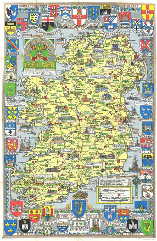
Historical Map of Ireland.
sold
- Digital Map Information
- Suitable for large format printing
- File Size: 28.5 MB
- File Type: ZIP / TIFF
- ICC color profile embedded
- Delivered instantly via download link
This is a delightful 1969 L.G. Bullock pictorial historical map of Ireland. Bullock's map shows the entire Emerald Isle as well as a small amount of the sea. The map is very elaborate and includes several intriguing aspects. (more details)
Ritter's outstanding 'Sundial Map' linking time and geography.

[Untitled Sundial Map]
sold
- Digital Map Information
- Suitable for large format printing
- DPI: 300
- File Size: 6.47 MB
- File Type: ZIP / TIFF
- ICC color profile embedded
- Delivered instantly via download link
A spectacular map of the utmost curiosity and unparalleled cartographic coolness, this is Franz Ritter's untitled 1640 map of the world on a polar gnomonic projection – often referred to as the 'Sundial Map.' ... (more details)
Important second edition of Mercator and Hondius' Map of the Arctic showing a break with 16th century cartographic convention.

Septentrionalium Terrarum descriptio.
sold
- Digital Map Information
- Suitable for large format printing
- DPI: 300
- File Size: 12.89 MB
- File Type: ZIP / TIFF
- ICC color profile embedded
- Delivered instantly via download link
This is the second edition of Gerard Mercator's map of the North Pole or Arctic, one of the great cartographer's most interesting and important maps. Mercator's Arctic projection has its roots in his ... (more details)