
Hagstrom, Andrew Gunnar (sold)

Andrew Gunnar Hagstrom (1890 - September 24, 1977) was a map publisher based in Maspeth, Queens. Hagstrom was a Swedish immigrant who came to new York in 1909 where took work milking cows at a farm near Coney Island, Brooklyn. He then worked in the meat packing industry while taking a degree in commercial art at the New York Mechanics Institute. Afterwords he founded a drafting business in Manhattan, creating a map to illustrate his drafting skill help customers locate his shop. His map proved popular and he expanded operations, founding the Hagstrom Map Company (1916 - 1968) and issuing additional maps of various parts of New York City and the surrounding regions. By 1949, Hagstrom had issued more than 150 maps, guides, and atlases, most of which focused on New York. Hagstrom pioneered a cartographic style that exaggerated street size to increase clarity and create additional room for large print readable labeling. Even the New York Subway system hired Hagstrom to produce its map, which was in use from the 1940s to 1958. Hagstrom died in 1977, at the age of 81. Hagstrom was knighted by the King of Sweden. His company flourished until 1968 when it was acquired by Macmillan. The brand has since passed through multiple corporate portfolios and is currently the property by Kappa Publishing Group.
Celebrates the 1933 opening of Rockefeller Center.
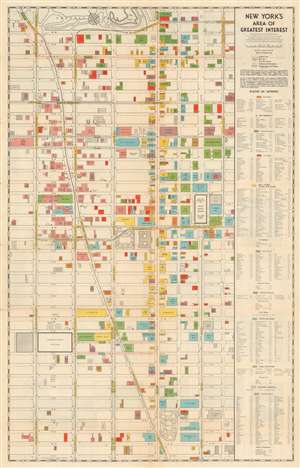
New York's Area of Greatest Interest.
sold
- Digital Map Information
- Suitable for large format printing
- Full resolution TIFF file
- ICC color profile embedded
- Delivered instantly via download link
This is a scarce 1933 first edition Robert Wentworth Floyd map of midtown Manhattan compiled for the Fifth Avenue Association and Rockefeller Center. Centered on Bryant Park, the map covers from 61st Street to 22nd Street and from 8th Avenue to Lexington Ave. Locations of note are color coded according to their function, with banks, churches, clubs, stores, hotels, office buildings, public buildings, railway terminals, and theaters differentiated. The verso contains text content promoting Rockefeller Center - which opened in the same year this map was published and most certainly contributed to its compilation. Also on the verso, there is a smaller map of New York City by Hagstrom illustrating transit routes. (more details)
Travel by radio.
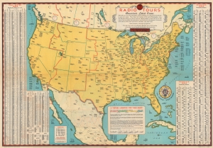
RCA Radio Tours - America's Latest Game.
sold
- Digital Map Information
- Suitable for large format printing
- Full resolution TIFF file
- ICC color profile embedded
- Delivered instantly via download link
This is a 1934 RCA Radiotron map of the United States. Presented as a game, radio stations, with their call signs and frequencies, are labeled throughout the U.S., Canada, Cuba, and Mexico. (more details)
Superb Golden Age pictorial map drawn to promote shopping and tourism to Downtown Brooklyn.
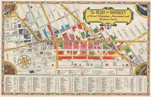
The Heart of Brooklyn A Great Shopping, Amusement and Business Center.
sold
- Digital Map Information
- Suitable for large format printing
- Full resolution TIFF file
- ICC color profile embedded
- Delivered instantly via download link
A nearly unknown but wonderful 1935 pictorial map of downtown Brooklyn published for the Downtown Brooklyn Association and prepared by the Hagstrom Company. The map was drawn to promote the shopping and nightlife in downtown Brooklyn, with particular attention to ... (more details)
Highlights Manhattan's many theatres, including the New Amsterdam and Lyric Theatres.
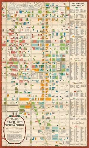
New York's Principal Theatre, Hotel, amd Shopping District.
sold
- Digital Map Information
- Suitable for large format printing
- File Size: 24.25 MB
- File Type: ZIP / TIFF
- ICC color profile embedded
- Delivered instantly via download link
This is a 1939 First Edition Hagstrom / R. W. Floyd map of Midtown Manhattan highlighting the Theatre District and its many theatres. The map depicts the city from Eighth Avenue to Lexington Avenue and from West 61st Street, Central Park, and East 61st Street to 22nd Street. Although numerous buildings are illustrated, not all the city blocks are filled. Banks, churches, clubs, department stores, hotels, nightclubs, office buildings, public buildings, train stations, and theatres are shaded using various colors to allow for easy differentiation and identification. An index, situated along the map's right side, lists the identified locations, offers a color-coding key, and notes each building's coordinates on the map. (more details)
Early mapping of New York Subways.
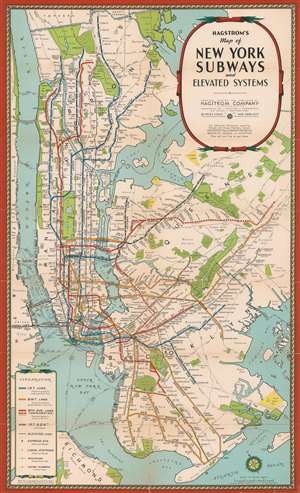
Hagstrom's Map of New York Subways and elevatd Systems.
sold
- Digital Map Information
- Suitable for large format printing
- Full resolution TIFF file
- ICC color profile embedded
- Delivered instantly via download link
An uncommon early c. 1939 edition of Hagstrom's map of New York City showing subways and elevated trains, including the BMT and IRT lines. The map covers most of New York City with the exception of Staten Island. Parks are detailed, as are major avenues and streets, but he focus of the map is the subway and transit lines. Color coding defines the lines, the IRT (blue), BMT (yellow), 8th Avenue line (Red), Joint lines (blue and yellow). The map also attempts to show major railway lines. This map is undated but predates the 1939 merger of the December 12, 1939 merger of the IRT, BMT, IND (independent lines), the largest railroad merger in U.S. history. (more details)
A wonderful promotional piece for the 1939 New York World's Fair highlighting travel routes to the fair and all that the city has to offer visitors.
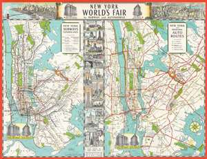
New York World's Fair by Subway and Automobile.
sold
- Digital Map Information
- Suitable for large format printing
- File Size: 25.94 MB
- File Type: ZIP / TIFF
- ICC color profile embedded
- Delivered instantly via download link
A promotional piece for the 1939 New York World's Fair, this c. 1939 Hagstrom map combines a New York City subway map and a map of road routes to the World's Fair together on one sheet. Both maps illustrate generally the same area from New Jersey to Nassau County on Long Island and from Westchester County to The Narrows. The grounds of the World's Fair in Queens are shaded orange and include an illustration of the Trylon and Perisphere, the monumental constructions that became the symbol of the fair.
More detail is included in New Jersey in the road map, allowing travelers by car to have a better understanding of how to navigate the routes to the fair. On the other hand, significant detail is depicted in the five boroughs of New York City on the subway map, as nearly every subway station is marked, the I.R.T., B.M.T., and Independent lines are illustrated by different colors, and elevated lines (most of which have since been dismantled) are included as well.
Eighteen vignettes sites around Manhattan, including the Metropolitan Museum of Art, the Empire State Building, and Rockefeller Center, separate the two maps. Each vignette is numbered and labeled, with these numbers appearing inscribed in black circles on the auto route map. Other sites, such as Grand Central Terminal and Penn Station, are sketched on the auto route map as well. The Hotel Times Square and the Hotel Breslin are drawn in profile on both maps and marked by stars. They also flank the map's title along the top border. Two aerial views of New York City are also situated along the top border. A view of Lower Manhattan and the Financial District is included on the left, which includes the Brooklyn Bridge. On the right is a view of Midtown looking to the east, with both the Empire State Building and the Chrysler building prominently illustrated. The Trylon and Persiphere are visible on the horizon at the top of the view. (more details)
More detail is included in New Jersey in the road map, allowing travelers by car to have a better understanding of how to navigate the routes to the fair. On the other hand, significant detail is depicted in the five boroughs of New York City on the subway map, as nearly every subway station is marked, the I.R.T., B.M.T., and Independent lines are illustrated by different colors, and elevated lines (most of which have since been dismantled) are included as well.
Eighteen vignettes sites around Manhattan, including the Metropolitan Museum of Art, the Empire State Building, and Rockefeller Center, separate the two maps. Each vignette is numbered and labeled, with these numbers appearing inscribed in black circles on the auto route map. Other sites, such as Grand Central Terminal and Penn Station, are sketched on the auto route map as well. The Hotel Times Square and the Hotel Breslin are drawn in profile on both maps and marked by stars. They also flank the map's title along the top border. Two aerial views of New York City are also situated along the top border. A view of Lower Manhattan and the Financial District is included on the left, which includes the Brooklyn Bridge. On the right is a view of Midtown looking to the east, with both the Empire State Building and the Chrysler building prominently illustrated. The Trylon and Persiphere are visible on the horizon at the top of the view. (more details)
A highly detailed city map of Brooklyn from around the beginning of World War II.
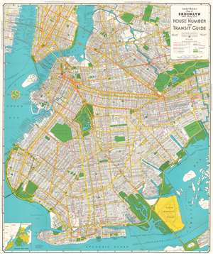
Hagstrom's Map of Brooklyn, New York City House Number and Transit Guide.
sold
- Digital Map Information
- Suitable for large format printing
- File Size: 49.56 MB
- File Type: ZIP / TIFF
- ICC color profile embedded
- Delivered instantly via download link
This is a c. 1940 Hagstrom map of Brooklyn, New York, and the immediate vicinity. Every street in Brooklyn is labeled, as are the streets in Manhattan up to East 25th Street and part of Queens. Subway lines are illustrated in red, with different symbols used to differentiate between the IRT West Side, the IRT East Side, the BMT, and the IND. Surface streetcar lines are also marked by thin red lines, while elevated subway lines are illustrated by solid black lines. The Long Island Railroad is also illustrated. Parks are colored green, along with cemeteries, which are identified by small crosses. Prospect Park and the Botanic Gardens are depicted in some detail, with both the Central Library and the Brooklyn Museum illustrated and labeled, along with Grand Army Plaza. (more details)
We miss you Broadway!
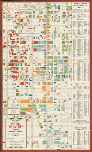
Hagstrom's Map of New York Theatres, Hotels, Shopping District.
sold
- Digital Map Information
- Suitable for large format printing
- Full resolution TIFF file
- ICC color profile embedded
- Delivered instantly via download link
This is a c. 1940 Hagstrom map of Midtown Manhattan highlighting the Theatre District and its many theatres. The map depicts the city from Eighth Avenue to Lexington Avenue and from West 61st Street, Central Park, and East 61st Street to 22nd Street. Although numerous buildings are illustrated, not all the city blocks are filled. Banks, churches, clubs, department stores, hotels, nightclubs, office buildings, public buildings, train stations, and theatres are shaded using various colors to allow for easy differentiation and identification. An index, situated along the map's right side, lists the identified locations, offers a color-coding key, and notes each building's coordinates on the map. (more details)
Highlights Manhattan's many theatres, including the New Amsterdam and Lyric Theatres.
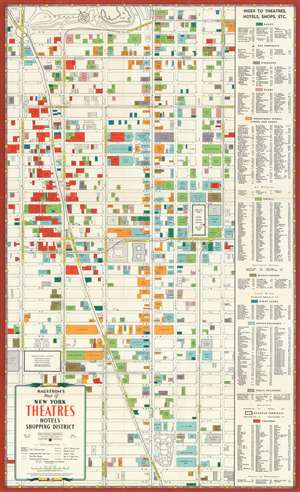
Hagstrom's Map of New York Theatres, Hotels, Shopping District.
sold
- Digital Map Information
- Suitable for large format printing
- File Size: 26.72 MB
- File Type: ZIP / TIFF
- ICC color profile embedded
- Delivered instantly via download link
This is a c. 1940 Hagstrom map of Midtown Manhattan highlighting the Theatre District and its many theatres. The map depicts the city from Eighth Avenue to Lexington Avenue and from West 61st Street, Central Park, and East 61st Street to 22nd Street. Although numerous buildings are illustrated, not all the city blocks are filled. Banks, churches, clubs, department stores, hotels, nightclubs, office buildings, public buildings, train stations, and theatres are shaded using various colors to allow for easy differentiation and identification. An index, situated along the map's right side, lists the identified locations, offers a color-coding key, and notes each building's coordinates on the map. (more details)
Everything a Visitor could want in friendly New York City.
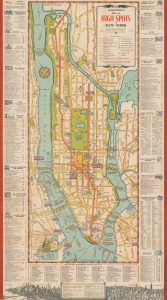
Hagstrom's Map of High Spots in New York.
sold
- Digital Map Information
- Suitable for large format printing
- File Size: 25.18 MB
- File Type: ZIP / TIFF
- ICC color profile embedded
- Delivered instantly via download link
This is a 1940 Hagstrom map of New York City. Highlighting sites throughout the city, many with small pictorial icons, the map caters to the casual sightseer by marking tourist sites and the more dedicated visitor in chronicling nightclubs and theaters. (more details)
Published for military personnel visiting New York during World War II.
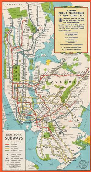
New York Subways.
sold
- Digital Map Information
- Suitable for large format printing
- Full resolution TIFF file
- ICC color profile embedded
- Delivered instantly via download link
An uncommon c. 1944 edition of Hagstrom's map of New York City showing subways and elevated trains, including the BMT and IRT lines. The map covers most of New York City with the exception of Staten Island. Parks are detailed, as are major avenues and streets, but the focus of the map is the subway and transit lines. Color coding defines the lines, the IRT (blue), BMT (yellow), IND (Red), and Joint lines (blue and yellow). The map also attempts to show major railway lines. (more details)
For military personnel visiting New York during World War II.
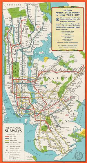
New York Subways.
sold
- Digital Map Information
- Suitable for large format printing
- Full resolution TIFF file
- ICC color profile embedded
- Delivered instantly via download link
An uncommon c. 1944 edition of Hagstrom's map of New York City showing subways and elevated trains, including the BMT and IRT lines. The map covers most of New York City with the exception of Staten Island. Parks are detailed, as are major avenues and streets, but the focus of the map is the subway and transit lines. Color coding defines the lines, the IRT (blue), BMT (yellow), IND (Red), and Joint lines (blue and yellow). The map also attempts to show major railway lines. (more details)
Comic take on World War II Rationing.
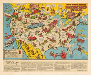
Bill Wiffletree's Ration Map of U.S.
sold
- Digital Map Information
- Suitable for large format printing
- File Size: 39.46 MB
- File Type: ZIP / TIFF
- ICC color profile embedded
- Delivered instantly via download link
A fine example of Edward McCandish's rarest map, his 1944 pictorial 'Bill Whiffletree' Ration Map of the United States. The map offers a humorous satirical perspective on the hotly contested and controversial government rationing program then in effect. Stylistically, the map is similar to McCandish's earlier Bootlegger's Map. As part of the World War II OPA Rationing Program, coupon books were issued for many common household goods including sugar, meat, cheese, fish and milk. Purchases of such items could only be completed with a corresponding coupon. For some, rationing was a patriotic duty, while others were frustrated by want. Some of the humorous commentary drives the conflict home: 'Pappy Don't Even Know What He's A-Layin' Fer - A German, A Revenooer, Er A Japanee'; 'On Exhibition Today Only The Last Idaho Potato'; and 'How About a Light, Pal? Matches is Rationed Over Here.' (more details)
Everything a Visitor could want in friendly New York City.
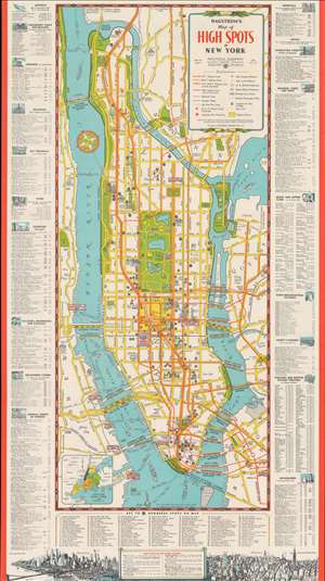
Hagstrom's Map of High Spots in New York.
sold
- Digital Map Information
- Suitable for large format printing
- File Size: 40.74 MB
- File Type: ZIP / TIFF
- ICC color profile embedded
- Delivered instantly via download link
This is a 1945 Hagstrom map of New York City. Highlighting sites throughout the city, many with small pictorial icons, the map caters to the casual sightseer by marking tourist sites as well the more dedicated visitor, in chronicling nightclubs and theaters. (more details)
Mapping New York Nightlife.
Hagstrom's Map of High Spots in New York.
sold
- Digital Map Information
- Suitable for large format printing
- Full resolution TIFF file
- ICC color profile embedded
- Delivered instantly via download link
This is a 1945 Hagstrom map of New York City, presenting an enlightening overview of New York nightlife near the end of the war era. (more details)
Everything a Visitor Could Want To Do In Friendly New York City
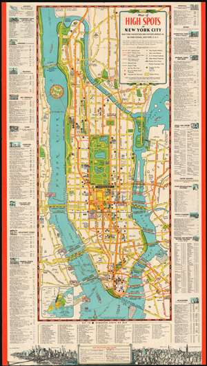
Map of High Spots in New York City.
sold
- Digital Map Information
- Suitable for large format printing
- File Size: 28.17 MB
- File Type: ZIP / TIFF
- ICC color profile embedded
- Delivered instantly via download link
This 1949 Hagstrom Map of New York City, was produced for and published by the New York Convention and Visitors Bureau and the Department of Commerce. It highlights for the visitor to New York a wide array of The City's attractions, ranging from points of interest for the casual sightseer to nightclubs for the more dedicated visitor. (more details)
Highlights Manhattan's many theatres, including the New Amsterdam and Lyric Theatres, as well as the newly-constructed United Nations Headquarters.
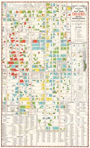
Hagstrom's Map of New York Theatres, Hotels, Shopping District and United Nations Headquarters.
sold
- Digital Map Information
- Suitable for large format printing
- File Size: 32.76 MB
- File Type: ZIP / TIFF
- ICC color profile embedded
- Delivered instantly via download link
This is a c. 1950 Hagstrom map of Midtown Manhattan highlighting the Theatre District and its many theatres. The map depicts the city from Eighth Avenue to the East River and from West 61st Street, Central Park, and East 61st Street to 26th Street. Although myriad buildings are illustrated, not all the city blocks are filled. Banks, churches, clubs, department stores, hotels, nightclubs, office buildings, public buildings, train stations, and theatres are shaded using various colors to allow for easy differentiation and identification.
The focus, of course, is on the areas many theatres, which are shaded red. Numerous theatres still in operation today are labeled here, including the New Amsterdam, Lyric, Majestic, Broadhurst, Booth, Golden, Barrymore, and the Music Box. Numerous others illustrated here have since been closed or repurposed. The newly-constructed United Nations Headquarters, located along the East River between East 42nd Street and East 48th Street, is illustrated and the Secretariat Building, the Meeting Halls, and the Assembly Hall are all labeled. Other New York City landmarks that fall within the map's borders include the Empire State Building, the central branch of the New York Public Library, the Museum of Modern Art (MoMA), Bryant Park, Grand Central Station, and Herald Square. Both Macy's and Bloomingdale's are labeled, as are the Waldorf Astoria Hotel and the Plaza Hotel. An index, situated along the bottom of the map, lists the identified locations, provides the color with which they are shaded, and each building's location on the map's grid. Streets and avenues are also labeled and subway lines are illustrated and identified as well. (more details)
The focus, of course, is on the areas many theatres, which are shaded red. Numerous theatres still in operation today are labeled here, including the New Amsterdam, Lyric, Majestic, Broadhurst, Booth, Golden, Barrymore, and the Music Box. Numerous others illustrated here have since been closed or repurposed. The newly-constructed United Nations Headquarters, located along the East River between East 42nd Street and East 48th Street, is illustrated and the Secretariat Building, the Meeting Halls, and the Assembly Hall are all labeled. Other New York City landmarks that fall within the map's borders include the Empire State Building, the central branch of the New York Public Library, the Museum of Modern Art (MoMA), Bryant Park, Grand Central Station, and Herald Square. Both Macy's and Bloomingdale's are labeled, as are the Waldorf Astoria Hotel and the Plaza Hotel. An index, situated along the bottom of the map, lists the identified locations, provides the color with which they are shaded, and each building's location on the map's grid. Streets and avenues are also labeled and subway lines are illustrated and identified as well. (more details)
Highlights Manhattan's many theatres, including the New Amsterdam and Lyric Theatres, as well as the newly-constructed United Nations Headquarters.
Hagstrom's Map of New York Theatres, Hotels, Shopping District and United Nations Headquarters.
sold
- Digital Map Information
- Suitable for large format printing
- Full resolution TIFF file
- ICC color profile embedded
- Delivered instantly via download link
This is a c. 1950 Hagstrom map of Midtown Manhattan highlighting the Theatre District and its many theatres. The map depicts the city from Eighth Avenue to the East River and from West 61st Street, Central Park, and East 61st Street to 26th Street. Although myriad buildings are illustrated, not all the city blocks are filled. Banks, churches, clubs, department stores, hotels, nightclubs, office buildings, public buildings, train stations, and theatres are shaded using various colors to allow for easy differentiation and identification. (more details)
Silver Springs - the largest tourist attractions in Florida in the 1950s.
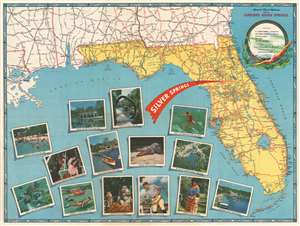
America's Finest Highways Lead to Florida's Silver Springs.
sold
- Digital Map Information
- Suitable for large format printing
- Full resolution TIFF file
- ICC color profile embedded
- Delivered instantly via download link
This is a 1952 Hagstrom map of Florida. Created as a promotional piece for Silver Springs, a tourist attraction outside Ocala, Florida, a large red 'arrow' emphasizes Silver Springs' location in central Florida. U.S. highways are illustrated in red and four highways pass through Ocala, highlighting how easy it would be for travelers to stop at Silver Springs on their way to their final destination or on their way home. Gorgeous color photographs increase Silver Springs' appeal and promote its crystal-clear water, glass-bottom boats, reptile house, and its rhesus macaques. Throughout the 1930s and 1940s, billboards and other advertisements appeared along highways around the country proclaiming the wonders found at Silver Springs, pointing the way, and telling motorists just how far it was from where they were to this paradise. By the 1950s, Silver Springs was the largest tourist attraction in Florida. Today, the 'attraction' is now part of Silver Springs State Park, but the glass-bottom boats (and the slightly dangerous monkeys) still beckon thousands of visitors every year. A wonderful pictorial border, consisting of illustrations of fish, a woman swimming, and a glass-bottom boat, surrounds the entire map. Five maps on the verso detail the highway connections between locations throughout the United States and Silver Springs. (more details)
A plan to improve the New York City Subway.
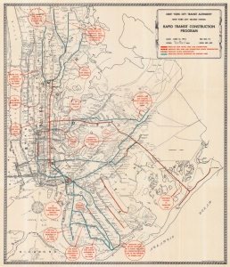
This is a 1954 Hagstrom map of New York City Subway construction projects. It illustrates developments, such as the 2nd Avenue Line, that are only now coming to fruition. (more details)
New York's world famous theaters, including Lincoln Center and the Metropolitan Opera.
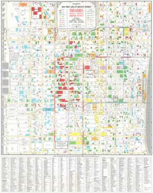
Hagstrom's Map of New York Area of Greatest Interest: Theatres, Hotels, Motels, Shopping District
sold
This is a c. 1966 Hagstrom map of Midtown Manhattan highlighting the Theatre District and its many theatres. The map depicts the city from the West Side Highway and the Hudson River Piers to the East River and from West 66th Street, Central Park, and East 66th Street to 30th Street. Although myriad buildings are illustrated, not all the city blocks are filled. Theatres, hotels and motels, garages or parking lots, prominent stores, tv or radio stations, churches and synagogues, night or supper clubs, and special points of interest are shaded using various colors to allow for easy differentiation and identification. (more details)