
Murray, John (sold)
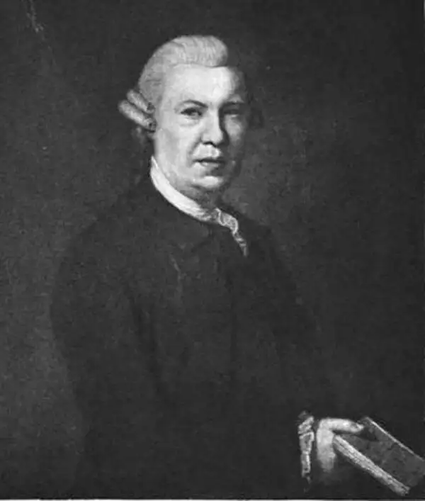
John Murray I (1737 - 1793) founded the British publishing firm John Murray (1768 - present) in London. Born in Edinburgh, Murray served as an officer in the Royal Marines and built a list of authors that included Isaac D’Israeli and published the English Review. Murray the elder also was one of the founding sponsors of the London evening newspaper The Star in 1788. John Murray II (November 27 1778 - June 27, 1843) continued the family publishing business and developed it into one of the most important and influential publishing houses in Britain. The list of authors published by the firm grew to include Jane Austen, Sir Walter Scott, Washington Irving, George Crabbe, and Lord Byron under his tenure. Murray II also moved the business to 50 Albermarle Street in Mayfair, which became famous for Murray’s tradition of ‘four o’clock friends’, which was afternoon tea with his writers. John Murray III (1808 - 1892) continued to grow the business, and the firm published the first English translation of Goethe’s Theory of Colours, David Livingstone’s Missionary Travels and Charles Darwin’s Origin of Species during his tenure. Murray also published Herman Melville’s first two books. The firm began publishing Murray Handbooks in 1836, an ancestor of all modern travel guides. Sir John Murray IV (1851 - 1928) was publisher to Queen Victoria. Three successive Murray’s after Murray IV led the business until it was purchased by Hodder Headline in 2002, which was acquired by the French conglomerate Lagardère Group in 2004. Today, Murray is an imprint of Lagardère under the imprint Hachette UK.
A little known coast...

A Draught of the Windward Cost of the Mosquito Shore from Point Pattuck to St. Johns and Continued on the Spanish Main, to Escuda Veragua with the Islands, Keys, and Shoals, From the latest Authorities.
sold
- Digital Map Information
- Suitable for large format printing
- File Size: 5.89 MB
- File Type: ZIP / TIFF
- ICC color profile embedded
- Delivered instantly via download link
This is a scarce 1785 John Lodge map of the Mosquitia or Mosquito Coast, roughly corresponding to present-day eastern Nicaragua and Costa Rica. The map was issued to illustrate the heated colonial conflict between England and Spain over the remote and inhospitable coastline. (more details)
The first two years of the disastrous Coppermine expedition.
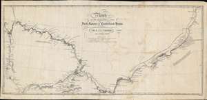
Route of the Expedition from York County to Cumberland House and the Summer and Winter Tracks from thence to Isle a la Crosse in 1819 and 1820.
sold
- Digital Map Information
- Suitable for large format printing
- DPI: 600
- File Size: 9.62 MB
- File Type: ZIP / TIFF
- ICC color profile embedded
- Delivered instantly via download link
This is an 1823 John Franklin map of Manitoba and Saskatchewan, Canada. Depicting from York Factory, Manitoba, to Lac Île-à-la-Crosse in Saskatchewan, the map traces the first two years of Franklin's ill-fated Coppermine Expedition. Franklin marks the expedition's daily camps, beginning on September 9, 1819, in York Factory. Short notes provide information concerning the soil, trees, and other flora. Locations of latitude measurements are even noted. Numerous lakes are identified, including Lake Winnipeg. Portages (when the river was impassable by boat) also appear along the expedition's route and the distance of each is provided in yards. (more details)
One of the earliest obtainable maps of Singapore.
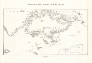
Sketch of the Island of Singapore.
sold
- Digital Map Information
- Suitable for large format printing
- DPI: 600
- File Size: 8.36 MB
- File Type: ZIP / TIFF
- ICC color profile embedded
- Delivered instantly via download link
A scarce, early map and chart of Singapore, published by John Murray in 1830 for Lady Sophia Raffles' Memoir of the life and public services of Sir Thomas Stamford Raffles, four years after her husband's death. It depicts the nascent colonial city in the early years after the development of the Raffles Town Plan, a partially-realized scheme for the city's future development. (more details)
Illustrates the expedition of Richard and John Lander down the Niger River.
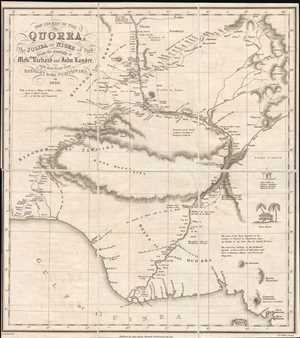
The Course of the Quorra, the Joliba or Niger of Park from the Journals of Messrs Richard and John Lander, with their Route from Badagry to the Northward in 1830.
sold
- Digital Map Information
- Suitable for large format printing
- DPI: 300
- File Size: 3.16 MB
- File Type: ZIP / TIFF
- ICC color profile embedded
- Delivered instantly via download link
This is an 1831 Alexander Bridport Becher and John Murray map the course of the Niger River in Nigeria. The map, solidly in the tradition of early 19th century European maps of Africa, depicts the Niger River and the route followed by the expedition led by Richard ... (more details)
One of the Earliest Maps of the Colony of Western Australia
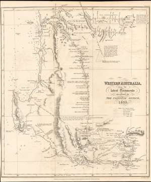
Western Australia from the Latest Documents received in The Colonial Office 1832.
sold
- Digital Map Information
- Suitable for large format printing
- DPI: 600
- File Size: 8.3 MB
- File Type: ZIP / TIFF
- ICC color profile embedded
- Delivered instantly via download link
This 1832 Royal Geographical Society map of Western Australia is one of the earliest printed maps of the newly established Colony of Western Australia, hitherto known as the Swan River Colony. The map encompasses the area north of Perth and south coast beyond Albany. The mapping of the interior reveals the first European efforts to explore the region. (more details)
The only commercial atlas map to specifically illustrate Nebraska territory at its ephemeral fullest.
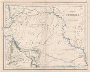
Territory of Nebraska.
sold
- Digital Map Information
- Suitable for large format printing
- File Size: 4.79 MB
- File Type: ZIP / TIFF
- ICC color profile embedded
- Delivered instantly via download link
This is a rare 1857 Henry Darwin Rogers map of the ephemeral Nebraska Territory at its fullest, extending from Kansas to the Canadian border. Few maps illustrate Nebraska in this form, and most of those only as part of a larger map. The presently offered map is ... (more details)
Summary of seventy years of Antarctic exploration.
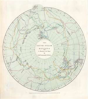
The South Polar Regions to Illustrate the Paper by Staff Commander J.E. Davis.
sold
- Digital Map Information
- Suitable for large format printing
- File Size: 4.23 MB
- File Type: ZIP / TIFF
- ICC color profile embedded
- Delivered instantly via download link
This is an 1869 John Murray map of Antarctic / South Pole explorations between 1773 and 1845. Dashed lines traced in hand color follow the expeditions of Cook, Bellinghausen, Weddel, Biscoe, Kemp, D'Urville, Balleny, Wilkes, Ross, and Moore. Each explorer's course is labeled, many with the month and year, and an arrow illustrating the direction they were traveling. Very little detail on the Antarctic continent itself is present. Islands, points, 'lands' named by or for explorers, and notes concerning the concentrations of sea ice appear throughout. Parts of New Zealand and South America are included and provide some geographical context for the map's audience. (more details)
Corfu, a popular tourist destination for the ultra-wealthy.
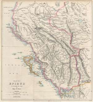
Map of Epirus to accompany the Paper by Major R. Stuart.
sold
- Digital Map Information
- Suitable for large format printing
- File Size: 9.01 MB
- File Type: ZIP / TIFF
- ICC color profile embedded
- Delivered instantly via download link
An important geographical region in antiquity and a popular tourist destination today, this is an 1869 John Murray map of Corfu and Epirus, Greece. Corfu appears in the Ionian Sea just off the coast of Epirus. Cities and towns throughout, including Corfu, the largest city on the island of Corfu, and Ioannina (labeled here as Yanina), the regional capital. (more details)
Early study on manmade climate change.
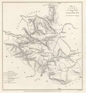
Map of Coorg to accompany the Paper by George Bidie, M.B.
sold
- Digital Map Information
- Suitable for large format printing
- File Size: 2.88 MB
- File Type: ZIP / TIFF
- ICC color profile embedded
- Delivered instantly via download link
This is an 1869 John Murray map of Kodagu (formerly Coorg) District in Karnataka, India. This is one of the earliest maps we are aware of to deal with manmade climate change. Created to accompany a paper published in The Journal of the Royal Geographical Society. The paper's author, George Bidie, described Coorg to his readers:
Coorg lies near the centre of the Western Ghâts, and chiefly in the eastern aspect of the range. On its western margin the crests of the chain rise up in bold peaked mountain masses, some of which attain the height of 5000 feet above the sea, and to the east of these the country consists of a series of low, long-backed hills, with intersecting deep-set valleys, running out towards, and gradually subsiding in, the table-land of Mysore.(more details)
Farthest north...
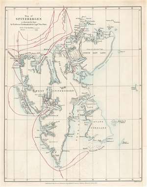
Map of Spitzbergen to illustrate the Paper by Professor Nordenskiöld and Captain Von Otter.
sold
- Digital Map Information
- Suitable for large format printing
- File Size: 3.25 MB
- File Type: ZIP / TIFF
- ICC color profile embedded
- Delivered instantly via download link
This is an 1868 John Murry Map of Spitsbergen in the Svalbard Archipelago, Norway, drawn to illustrate the 1868 Arctic expedition led by Adolf Erik Nordenskiöld and Frederick Wilhelm von Otter. Situated off the northern coast of Norway, Spitsbergen is the only permanently inhabited island in the archipelago. Numerous bays, points, coastal islands, fjords, and other important coastal locations are identified. Red lines trace the expedition's route. Its goals were to study the region's fauna, flora, geography, and geology. Its most notable achievement is that Nordenskiöld and Von Otter reached the highest latitude ever visited by humans in the Eastern Hemisphere up until that time, 81°40' North Latitude. Nordenskiöld and Von Otter both contended that if their ship, the Sofia had not been damaged by ice at that latitude, they would have been able to travel significantly further north, perhaps even to 83°N. (more details)
Follows the founder of the Denver and Rio Grande Railroad.
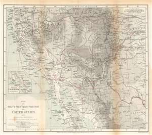
Map of the Southwestern Portion of the United States, and of Sonora and Chihuahua.
sold
- Digital Map Information
- Suitable for large format printing
- File Size: 14.77 MB
- File Type: ZIP / TIFF
- ICC color profile embedded
- Delivered instantly via download link
This is an 1870 Ernst Georg Ravenstein map of the southwestern United States. The map traces William Abraham Bell's travels in the region, including his time with the Kansas Pacific Railroad Survey. A red line illustrates Bell's peregrinations from Kansas west to the Pacific Ocean, his voyage up the Pacific coast to San Francisco, and his overland trek back to Kansas. From Kansas, Bell headed east where he booked passage across the Atlantic to England. After the expedition Bell co-founded the Denver and Rio Grande Railway. (more details)
Farthest extent of European settlement in America before Columbus.
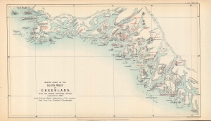
Sketch chart of the south west of Greenland from the Danish Admiralty Survey, corrected to 1873, with Professor Rafn's adaptation of the ancient sites from Ivar Bardsen's chorography.
sold
- Digital Map Information
- Suitable for large format printing
- File Size: 5.16 MB
- File Type: ZIP / TIFF
- ICC color profile embedded
- Delivered instantly via download link
A fascinating 1873 map of the southwest coast of Greenland, lithographed by Edward Weller for the Journal of the Royal Geographical Society, published by John Murray. It accompanied an article by Richard Henry Major, one of the journal's editors, which argued for two instances of pre-Columbian discovery of the Americas, one (later debunked) by the Venetian Zeno Brothers in the 14th century, and one by the Norse settlers of Greenland, later corroborated. (more details)
Highlights the Dead Sea and the Sea of Galilee.
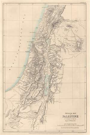
Physical Map of Palestine to accompany the Paper by Major C.W. Wilson R.E.
sold
- Digital Map Information
- Suitable for large format printing
- File Size: 6.77 MB
- File Type: ZIP / TIFF
- ICC color profile embedded
- Delivered instantly via download link
This is an 1873 John Murray map of Palestine, Israel, and the Holy Land highlighting the region's physical features. Depicting from Beirut south to Petra, the region's striking topography becomes immediately apparent. Many peaks are identified, including the Mount of Olives near Jerusalem, and their elevations provided. Both the Dead Sea and the Sea of Galilee are illustrated and labeled. The region's river network is detailed as well. Haifa, Jaffa, Tyre, Bethlehem, Hebron, Jericho, and Gaza are among the identified cities. (more details)
A guide to the historically and archaeologically rich region of Sistan.
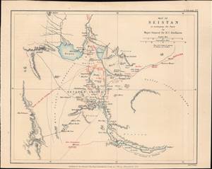
Map of Seistan, to accompany the Paper by Major-General Sir H.C. Rawlison.
sold
- Digital Map Information
- Suitable for large format printing
- File Size: 3.47 MB
- File Type: ZIP / TIFF
- ICC color profile embedded
- Delivered instantly via download link
This is a rare 1873 Weller and H. C. Rawlinson map of Sistan (Seistan), on the border of modern Iran and Afghanistan near Baluchistan, Pakistan. It was prepared to illustrate the British intelligence officer, H. C. Rawlinson's, expedition into the region - a strategic reconnaissance in the Great Game. This region remains to this day little known and is rarely prested cartographically - this possibly being the only 19th-century specific map. (more details)
First scientific survey of Central Madagascar.
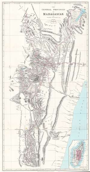
The Central Provinces of Madagascar.
sold
- Digital Map Information
- Suitable for large format printing
- File Size: 21.02 MB
- File Type: ZIP / TIFF
- ICC color profile embedded
- Delivered instantly via download link
This is an 1875 John Mullens map of the central provinces of Madagascar - considered the first scientific survey of the central provinces around Antananarivo, the island's capital. Red lines trace Mullens's peregrinations as an official of the London Missionary Society. He was widely welcomed as a guest and given free rein to collect geographical and cartographic data. Throughout, cites, towns, and villages are identified for the first time on a modern map. Mountains are named and elevations given. An inset in the lower right illustrates this map in the context the entirety of Madagascar. (more details)
Pundit explorations in Tibet and Nepal.
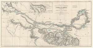
Map showing Routes of Native Explorers in Tibet and Nepal to Illustrate the Papers by Mr. Markham and Lieut. Colonel T.G. Montgomerie.
sold
- Digital Map Information
- Suitable for large format printing
- File Size: 14.11 MB
- File Type: ZIP / TIFF
- ICC color profile embedded
- Delivered instantly via download link
Discover routes of secret survey and exploration trips in the vicinity of Mount Everest with this 1875 John Murray and Royal Geographical Society map of Nepal and Tibet. Dashed and dotted lines follow the routes of 'pundits', native Indian surveyors employed by the British to secretly survey Tibet and Nepal - areas restricted to the British on pain of death. (more details)