
Weller, Edward (sold)

Edward Weller (July 1, 1819 - 1884) was a cartographer and engraver based in London. Weller was a nephew of another well-known map publisher Sidney Hall (1788 - 1831), who gave him 50 Pounds to pay his apprenticeship fees. He engraved for many prominent mapmakers and was active enough in the community to be recommended for membership to the Royal Geographical Society in 1851 on the recommendation of John Arrowsmith, among others. He eventually inherited the Sidney Hall map business which led him to follow Arrowsmith as the unofficial geographer to the Royal Geographical Society. Weller was among the first map printers in London to embrace lithography. His best known work appears in Cassell's Weekly Dispatch Atlas, published in monthly segments for subscribers of the 'Weekly Dispatch' newspaper. This collection of maps eventually grew to include much of the known world. Published in various editions from 1855 through the early 1880s. Weller died in May of 1884, leaving behind a successful business and an unhappy widow. His son, Francis Sidney Weller (1849 - 1910), followed in his father's footsteps and continued the family map business. The atlas Mackenzie's Comprehensive Gazetteer of England and Wales was published in 1894 and bore F. S. Weller's signature on the maps.
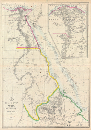
Egypt, Nubia, Abyssinia, and the Red Sea.
sold
- Digital Map Information
- Suitable for large format printing
- DPI: 300
- File Size: 57.26 MB
- File Type: ZIP / TIFF
- ICC color profile embedded
- Delivered instantly via download link
This is a hand colored map of Egypt, Nubia and Abyssinia, dating to 1858, by London cartographer Edward Weller. Depicts northeastern Africa from what is today central Ethiopia, northward along the Nile to Egypt and the Delta. Shows the Red Sea in full along with ... (more details)
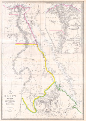
Egypt, Nubia, Abyssinia and the Red Sea.
sold
- Digital Map Information
- Suitable for large format printing
- File Size: 3.47 MB
- File Type: ZIP / TIFF
- ICC color profile embedded
- Delivered instantly via download link
This hand colored map is a lithographic transfer, dating to 1858, by London cartographer Edward Weller. Depicts northeastern Africa from the city of Addis Ababa in Ethiopia, north along the Nile to Egypt and the Delta. Shows the Red Sea in full along with ... (more details)
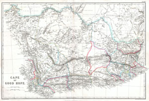
Cape of Good Hope.
sold
- Digital Map Information
- Suitable for large format printing
- File Size: 8.99 MB
- File Type: ZIP / TIFF
- ICC color profile embedded
- Delivered instantly via download link
An extremely attractive c. 1860 of South Africa and the Cape of Good Hope. Covers much of the southern top of Africa from S. Helena Bay and the Cape of Good Hope to 'Kaffir Land' in the east. This highly detailed map is most likely based on Edward ... (more details)
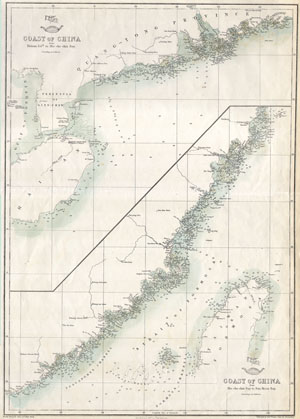
Coast of China from Hainan 1s1d. to Hie-che-chin Bay / Coast of China fromHie-che-chin Bay to San Moon Bay
sold
- Digital Map Information
- Suitable for large format printing
- File Size: 1.77 MB
- File Type: ZIP / TIFF
- ICC color profile embedded
- Delivered instantly via download link
This hand colored map is a lithographic transfer, dating to 1863, by London cartographer Edward Weller. Depicts the coast of China, including the Strait of Formosa and most of Taiwan or Formosa Island. Depth soundings indicated in fathoms along ... (more details)
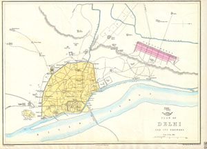
Plan of Delhi and its Environs.
sold
- Digital Map Information
- Suitable for large format printing
- DPI: 300
- File Size: 5.21 MB
- File Type: ZIP / TIFF
- ICC color profile embedded
- Delivered instantly via download link
This is a seldom seen map of Delhi, India, dating to 1858, by London cartographer Edward Weller. Depicts the city of Delhi shortly after the suppression of the Indian Mutiny in 1857. Oriented to the west. Shows what is today Old Delhi west of the ... (more details)
The largest original map of Victorian London obtainable.
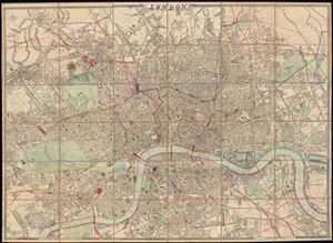
London.
sold
- Digital Map Information
- Suitable for large format printing
- File Size: 25.36 MB
- File Type: ZIP / TIFF
- ICC color profile embedded
- Delivered instantly via download link
A remarkable and monumental map of London, this is Weller and Cassell's 1866 wall map of London. When it was first issued in 1861 this was the largest scale map of London yet produced. Cassell was justly proud of his map bragging, 'as well as ... (more details)
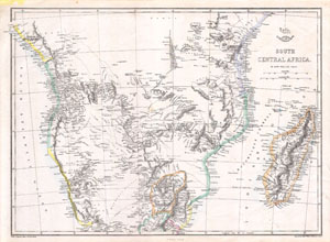
South Central Africa.
sold
- Digital Map Information
- Suitable for large format printing
- File Size: 3.19 MB
- File Type: ZIP / TIFF
- ICC color profile embedded
- Delivered instantly via download link
This is an 1868 Weekly Dispatch Atlas map of south-central Africa. (more details)
Corfu, a popular tourist destination for the ultra-wealthy.
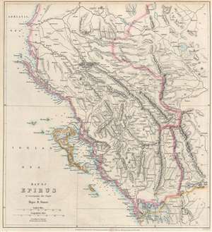
Map of Epirus to accompany the Paper by Major R. Stuart.
sold
- Digital Map Information
- Suitable for large format printing
- File Size: 9.01 MB
- File Type: ZIP / TIFF
- ICC color profile embedded
- Delivered instantly via download link
An important geographical region in antiquity and a popular tourist destination today, this is an 1869 John Murray map of Corfu and Epirus, Greece. Corfu appears in the Ionian Sea just off the coast of Epirus. Cities and towns throughout, including Corfu, the largest city on the island of Corfu, and Ioannina (labeled here as Yanina), the regional capital. (more details)
Early study on manmade climate change.
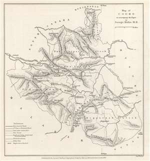
Map of Coorg to accompany the Paper by George Bidie, M.B.
sold
- Digital Map Information
- Suitable for large format printing
- File Size: 2.88 MB
- File Type: ZIP / TIFF
- ICC color profile embedded
- Delivered instantly via download link
This is an 1869 John Murray map of Kodagu (formerly Coorg) District in Karnataka, India. This is one of the earliest maps we are aware of to deal with manmade climate change. Created to accompany a paper published in The Journal of the Royal Geographical Society. The paper's author, George Bidie, described Coorg to his readers:
Coorg lies near the centre of the Western Ghâts, and chiefly in the eastern aspect of the range. On its western margin the crests of the chain rise up in bold peaked mountain masses, some of which attain the height of 5000 feet above the sea, and to the east of these the country consists of a series of low, long-backed hills, with intersecting deep-set valleys, running out towards, and gradually subsiding in, the table-land of Mysore.(more details)
Farthest north...
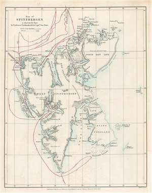
Map of Spitzbergen to illustrate the Paper by Professor Nordenskiöld and Captain Von Otter.
sold
- Digital Map Information
- Suitable for large format printing
- File Size: 3.25 MB
- File Type: ZIP / TIFF
- ICC color profile embedded
- Delivered instantly via download link
This is an 1868 John Murry Map of Spitsbergen in the Svalbard Archipelago, Norway, drawn to illustrate the 1868 Arctic expedition led by Adolf Erik Nordenskiöld and Frederick Wilhelm von Otter. Situated off the northern coast of Norway, Spitsbergen is the only permanently inhabited island in the archipelago. Numerous bays, points, coastal islands, fjords, and other important coastal locations are identified. Red lines trace the expedition's route. Its goals were to study the region's fauna, flora, geography, and geology. Its most notable achievement is that Nordenskiöld and Von Otter reached the highest latitude ever visited by humans in the Eastern Hemisphere up until that time, 81°40' North Latitude. Nordenskiöld and Von Otter both contended that if their ship, the Sofia had not been damaged by ice at that latitude, they would have been able to travel significantly further north, perhaps even to 83°N. (more details)
Farthest extent of European settlement in America before Columbus.
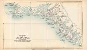
Sketch chart of the south west of Greenland from the Danish Admiralty Survey, corrected to 1873, with Professor Rafn's adaptation of the ancient sites from Ivar Bardsen's chorography.
sold
- Digital Map Information
- Suitable for large format printing
- File Size: 5.16 MB
- File Type: ZIP / TIFF
- ICC color profile embedded
- Delivered instantly via download link
A fascinating 1873 map of the southwest coast of Greenland, lithographed by Edward Weller for the Journal of the Royal Geographical Society, published by John Murray. It accompanied an article by Richard Henry Major, one of the journal's editors, which argued for two instances of pre-Columbian discovery of the Americas, one (later debunked) by the Venetian Zeno Brothers in the 14th century, and one by the Norse settlers of Greenland, later corroborated. (more details)
Highlights the Dead Sea and the Sea of Galilee.
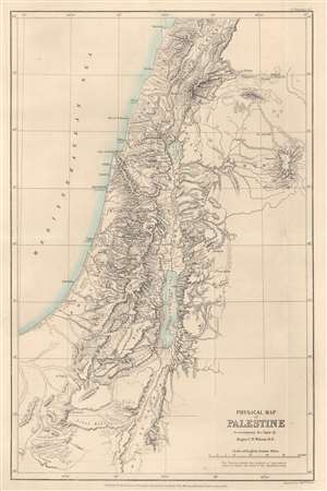
Physical Map of Palestine to accompany the Paper by Major C.W. Wilson R.E.
sold
- Digital Map Information
- Suitable for large format printing
- File Size: 6.77 MB
- File Type: ZIP / TIFF
- ICC color profile embedded
- Delivered instantly via download link
This is an 1873 John Murray map of Palestine, Israel, and the Holy Land highlighting the region's physical features. Depicting from Beirut south to Petra, the region's striking topography becomes immediately apparent. Many peaks are identified, including the Mount of Olives near Jerusalem, and their elevations provided. Both the Dead Sea and the Sea of Galilee are illustrated and labeled. The region's river network is detailed as well. Haifa, Jaffa, Tyre, Bethlehem, Hebron, Jericho, and Gaza are among the identified cities. (more details)
A guide to the historically and archaeologically rich region of Sistan.
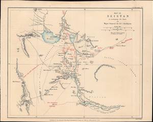
Map of Seistan, to accompany the Paper by Major-General Sir H.C. Rawlison.
sold
- Digital Map Information
- Suitable for large format printing
- File Size: 3.47 MB
- File Type: ZIP / TIFF
- ICC color profile embedded
- Delivered instantly via download link
This is a rare 1873 Weller and H. C. Rawlinson map of Sistan (Seistan), on the border of modern Iran and Afghanistan near Baluchistan, Pakistan. It was prepared to illustrate the British intelligence officer, H. C. Rawlinson's, expedition into the region - a strategic reconnaissance in the Great Game. This region remains to this day little known and is rarely prested cartographically - this possibly being the only 19th-century specific map. (more details)
Pre-Columbian Discovery of America, or an Elaborate Hoax?
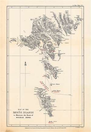
Map of the Færöe Islands, to Illustrate the Route of Nicolo Zeno.
sold
- Digital Map Information
- Suitable for large format printing
- File Size: 10.7 MB
- File Type: ZIP / TIFF
- ICC color profile embedded
- Delivered instantly via download link
This is Edward Weller's map of the Faroe Islands, published in 1873 in the Journal of the Royal Geographical Society, outlining the presumed route of Nicolò Zeno, a Venetian mariner who may have visited the islands in the late 14th century. The potential travels of Nicolò and his brother Antonio, including a possible discovery of the New World a century before Columbus, have been one of the most enduring debates in the history of cartography. (more details)
First scientific survey of Central Madagascar.
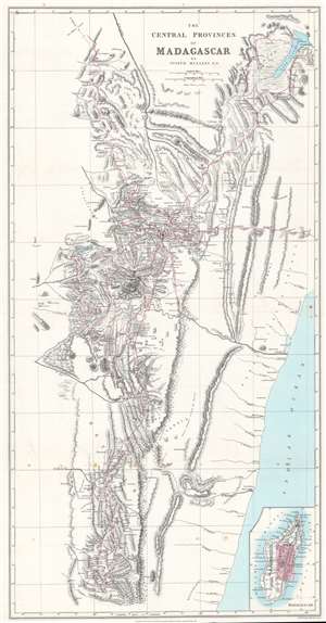
The Central Provinces of Madagascar.
sold
- Digital Map Information
- Suitable for large format printing
- File Size: 21.02 MB
- File Type: ZIP / TIFF
- ICC color profile embedded
- Delivered instantly via download link
This is an 1875 John Mullens map of the central provinces of Madagascar - considered the first scientific survey of the central provinces around Antananarivo, the island's capital. Red lines trace Mullens's peregrinations as an official of the London Missionary Society. He was widely welcomed as a guest and given free rein to collect geographical and cartographic data. Throughout, cites, towns, and villages are identified for the first time on a modern map. Mountains are named and elevations given. An inset in the lower right illustrates this map in the context the entirety of Madagascar. (more details)
One of the first western maps of Xinjiang, China illustrating a British trade mission from India into the region.
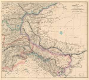
Map of Central Asia to accompany the Paper by Captain H. Trotter R.E., on the Geographical Results of Sir T.D. Forsyth's Mission to Kashgar, 1873 - 74.
sold
- Digital Map Information
- Suitable for large format printing
- File Size: 28.32 MB
- File Type: ZIP / TIFF
- ICC color profile embedded
- Delivered instantly via download link
This is an 1878 William John Turner and Royal Geographical Society map of Xinjiang, China that traces explorations of the Forsyth Mission of 1873 - 1874, making this one of the first detailed Western maps of the region. The map depicts the region from Peshawar, Pakistan to Tibet and from the Tian Shan Mountains to Pangong Lake. British, Russian, Chinese, and Afghan territory are outlined in different colors and are explained in a key situated in the lower right corner. The routes taken by the various different teams that constituted the Forsyth Mission are traced in red. Three different groups set out from Leh, in India, and met back up at Yarkand, in the 'Dominion of Yakoob Khan', and proceeded to Kashgar, where they met Yakub Beg. (more details)
The first complete and relatively accurate mapping of the Congo River.
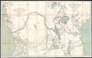
Westliche Hälfte von Äquatorial-Afrika und die Forschungsreisen zu Land und zu Wasser von Henry M. Stanley in den Jahren 1874 - 77. / Östliche Hälfte von Äquatorial-Afrika und den Forschungsreisen zu Land und zu Wasser von Henry M. Stanley in den Jahren 1874 - 77.
sold
- Digital Map Information
- Suitable for large format printing
- File Size: 81.23 MB
- File Type: ZIP / TIFF
- ICC color profile embedded
- Delivered instantly via download link
A map of considerable historical significance, this is the 1878 German edition Edward Weller and Henry Morton Stanley's map of Equatorial Africa, the first to describe the course of the entire Congo River. The map depicts the region from the Atlantic Ocean to the Indian Ocean and from the mouth of the Bight of Biafra to the southern tip of Lake Malawi (Lake Nyassa). The bright red line present on the map traces Stanley's expedition from Zanzibar to the Atlantic Ocean, with myriad locations identified along its path and some commentaries on different locations included. (more details)
Exploring Kilimanjaro.
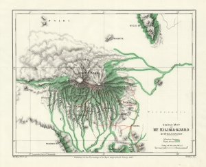
Sketch Map of Mt. Kilima-Njaro.
sold
- Digital Map Information
- Suitable for large format printing
- File Size: 11.4 MB
- File Type: ZIP / TIFF
- ICC color profile embedded
- Delivered instantly via download link
This is an 1884 Henry Johnston map of Mount Kilimanjaro, Tanzania. It is one of the earliest obtainable specific maps of Kilimanjaro. The Johnston expedition was set against the colonial backdrop of conflict between German and British claims in East Africa. (more details)
Exploring Mt. Kilimanjaro.
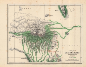
Sketch Map of Mt. Kilima-Njaro.
sold
- Digital Map Information
- Suitable for large format printing
- File Size: 12.08 MB
- File Type: ZIP / TIFF
- ICC color profile embedded
- Delivered instantly via download link
This is an 1884 Henry Johnston map of Mount Kilimanjaro, Tanzania. It is one of the earliest obtainable specific maps of Kilimanjaro. The Johnston expedition was set against the colonial backdrop of conflict between German and British claims in East Africa. (more details)
Details the Chinese, Taiwanese, and Filipino coasts.
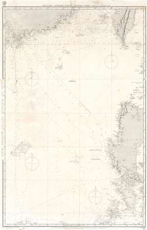
China Sea, Northern Portion, Eastern Sheet.
sold
- Digital Map Information
- Suitable for large format printing
- File Size: 36.89 MB
- File Type: ZIP / TIFF
- ICC color profile embedded
- Delivered instantly via download link
This is an 1887 British Admiralty nautical chart or maritime map of the South China Sea. The map depicts the region from Macau (Macao) to the Batan Islands and from the Pescadores Islands to Panay Island in the Philippines. Myriad depth soundings are indicated throughout, with particular focus given to the Chinese coast the Strait of Formosa, and the coastal waters of the islands in the Philippines, including Manila Bay. Coastal cities and towns are labeled in all depicted areas, such as Macao, Victoria, Hong Kong, and Manila, as are bays, points, and other coastal features. Shoals, banks, and various other hazards are also noted. Coastal lights are marked by yellow dots. (more details)
A reduction of the survey by Bjorn Gunnlaugsson - the first scientific survey of Iceland.
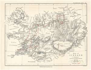
Map of Iceland to illustrate the Paper by Dr. K. Grossmann.
sold
- Digital Map Information
- Suitable for large format printing
- File Size: 5.08 MB
- File Type: ZIP / TIFF
- ICC color profile embedded
- Delivered instantly via download link
This is an 1894 Edward Weller map of Iceland. Created to accompany the paper given by Karl Grossmann to the Royal Geographical Society (RGS), the map depicts the entire island and is a reduction of the ground-breaking survey of Björn Gunnlaugsson. Grossmann's route is traced in red. His justification for presenting what may have appeared as 'a superfluous task' before the RGS was multiple, stating that the abundance of interesting physiographical features in Iceland is 'surprising' and that they 'are not always accessible', which led to a 'very fragmentary' understanding of Iceland. Grossmann also made a point of photographically documenting his journey, one of the first explorers to do so, stating that very few illustrations have ever been produced, with those that are most commonly reproduced in illustrated publications either being 'incorrect' or 'old time-honoured woodcuts, often copied secondhand, and mostly without acknowledgement'. (more details)
Arthur Donaldson Smith's explorations in East Africa.
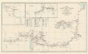
Map to illustrate Explorations in North East Africa.
sold
- Digital Map Information
- Suitable for large format printing
- File Size: 19.99 MB
- File Type: ZIP / TIFF
- ICC color profile embedded
- Delivered instantly via download link
This is a 1900 Arthur Donaldson Smith map of East Africa. The map depicts from the Gulf of Aden south into modern-day Ethiopia and then west across modern-day Kenya and Uganda to the Nile River. Red lines trace Donaldson Smith's two expeditions through the region, with a dotted line following his 1894 - 1895 expedition and a solid line highlighting his route in 1899 - 1900. Locations along both routes are labeled, and Donaldson Smith provides dates when his party arrived at certain places, allowing the viewer to follow both expedition's progress across the continent. An inset map of the 1895 expedition's path south from Lake Rudolf is situated in the upper left corner next to a triangulation survey of most of the territory between Lake Rudolf and the Nile River. A chart of Donaldson Smith's astronomical observations during both expeditions appears below the inset devoted to the triangulation survey. (more details)
A detailed Admiralty chart focusing on the coastlines and the islands.
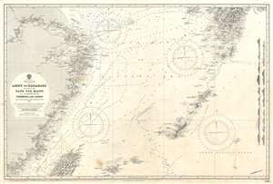
Amoy to Nagasaki Including the Yang Tse Kiang and the Islands Between Formosa and Japan.
sold
- Digital Map Information
- Suitable for large format printing
- File Size: 51.79 MB
- File Type: ZIP / TIFF
- ICC color profile embedded
- Delivered instantly via download link
This is a 1926 British Admiralty nautical chart or maritime map of the East China Sea. The map depicts the region from Nanking (Nanjing) and Shanghai, China to Kyushu and from Nagasaki, Japan to Taiwan / Formosa. Highly detailed, myriad depth soundings are indicated throughout, with the highest concentrations along the Chinese and Japanese coastlines, in the Formosa Strait, and encircling the numerous islands between Kyushu and Taiwan. Depth soundings are also present along high-traffic shipping routes, and along the Yangtze River past Nanjing. Innumerable cities, towns, and villages are labeled throughout, including Shanghai, Hangzhou, Nanjing, Nagasaki, and Kagoshima. Extreme detail is paid to the Okinawa Group, the Amami Groupand the Linschoten Islands, three island groups between Kyushu, the southernmost of the Home Islands of Japan, and Taiwan. (more details)