
Bestiary of fantastical northern monsters.

Meerwunder und seltzame Thier wie die in den Mitnåchtigen Låndern im Meer.
sold
- Digital Map Information
- Suitable for large format printing
- Full resolution TIFF file
- ICC color profile embedded
- Delivered instantly via download link
Often euphemistically referred to as Münster's Monsters, this is Sebastian Münster's bestiary of sea serpents and other astonishing monsters, some fictional, some real. The image first appeared in the expanded 1550 editions of Münster's Cosmographia, a work which for more than half a century provided the European literate layperson their best source of information about the world. Most of the beasts here are derived from a 1539 map of Scandinavia by Olaus Magnus. As fanciful as these creatures may appear, many depict actual creatures that Scandinavian sailors and whalemen occasionally encountered. Among the more recognizable beasts are whales identifiable by the spouts from their blowholes; two enormous lobsters (one of which is dragging a hapless sailor into the depths), a sea serpent (possibly an oarfish), the whale fish, and something that might very well be a walrus. There are fictional sea monsters too, including a pig faced sea beast, apparently seen by sailors in 1537, and the Sea Buffalo, something that looks like a cross between a bull and a fish. (more details)
Post-War Hong Kong.
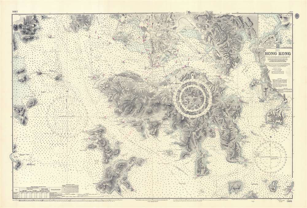
China. Hong Kong. Surveyed by Captn. Sir E. Belcher, H.M. Surveying Ship Sulphur, 1841...
sold
An iconic map of the utmost importance and rarity, this is the 1966 issue of Edward Belcher's 1843 nautical map of Hong Kong (香港) and vicinity. The map covers all of Hong Kong Island (香港島) as well as the Kowloon (九龍) Peninsula and, either in part or full, the adjacent island of Lan Tao (大嶼山), Peng Chau (坪洲), Hei Ling Chau (喜靈洲), Lamma (南丫島), Sheung Sze Mun (雙四門), Po Toi (蒲苔羣島), and Tung Lung Chau (東龍洲). Detail throughout is impressive, refined to the level of individual buildings, especially Victoria, Central, and on the Kowloon Peninsula. Belcher's work was so impressive that, although updated countless times, the base map, as here, remained unchanged for over 100 years. (more details)
Japanese colonialism in America.

邦人拓殖事業状況南米土地取得圖 / Japanese Residents and Land Acquired in South America.
sold
- Digital Map Information
- Suitable for large format printing
- File Size: 40.76 MB
- File Type: ZIP / TIFF
- ICC color profile embedded
- Delivered instantly via download link
A most curious Showa 1, or 1926, map of South America illustrating Japanese pre-war colonization. The map documents a little-known period of Japanese expansionism when the empire was attempting to use population and economic power to mirror European colonization. The map covers all of South America. Japanese immigration numbers are highlighted in red. Most impressive are the 192,823 immigrants in Brazil (São Paulo alone, illustrated via inset, had 190,896), and the 21,550 in Peru. At sea, lines illustrate shipping routes operated by the Nippon Yusen Line (red), and the Osaka Shosen Kaisha Line (blue). Critical resources are highlighted in red. (more details)
The cultural root of Shanghai.

松江府川沙縣 / Songjiang Fucheng County.
sold
- Digital Map Information
- Suitable for large format printing
- Full resolution TIFF file
- ICC color profile embedded
- Delivered instantly via download link
A rare Qing Dynasty, c. 1820, manuscript map of Songjiang, Shanghai. Before the founding of Shanghai as a concession city, Songjiang (松江鎮) was the largest city and town seat of Songjiang County, and as such, is considered the cultural root of Shanghai. As the foreign concessions grew and developed, Shanghai became the dominant regional center. Songjiang, located just to the southwest of central Shanghai, is today a historic suburb, Songjiang District. Like many ancient Chinese cities in the Yangtze delta region, this map reveals Songjiang as a city of canals, which served as key transportation infrastructure. Of the walls shown here, constructed in 751 AD, about 4.5 km remain - the rest were demolished between 1930 and 1982. (more details)
The last British redoubt its former colonies...
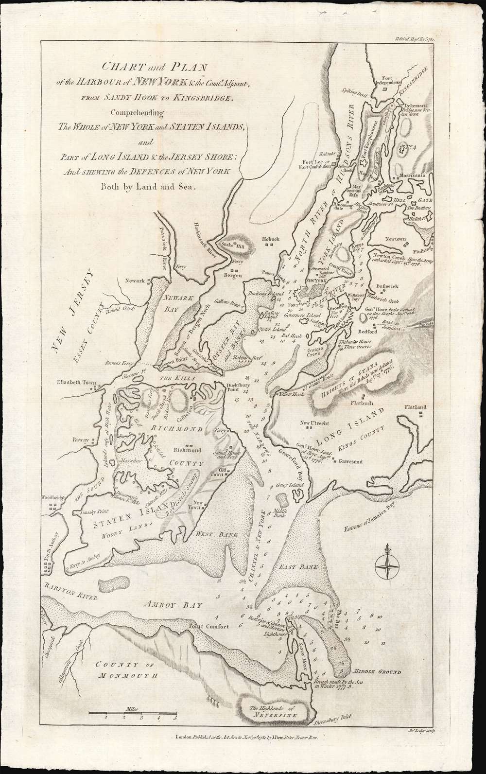
Chart and Plan of the Harbour of New York and the Couny Adjacent, from Sandy Hook to Kingsbridge, Comprehending The Whole ofNew York and Staten Islands, and Part of Long Isladn adn the Jersey Shore: And Shewing the Defences of New York Both by Land and Sea.
sold
- Digital Map Information
- Suitable for large format printing
- Full resolution TIFF file
- ICC color profile embedded
- Delivered instantly via download link
An important 1781 map of New York City near the end of the American Revolutionary War. This map was prepared by John Bew and engraved in London by John Lodge. Coverage extends from Sandy Hook to Fort Independence in the Bronx, and from Perth Amboy to western Long Island. When this map was issued, in November of 1781, news of the British defeat at the October 19, 1781 Battle of Yorktown, and the subsequent surrender of General Cornwallis, had already reached London. With its large, defensible harbor, multiple forts, and large defending force, it appeared that New York might soon be the last redoubt of British power in the rebelling colonies. This map reflects New York's defensive ability, citing the locations of new forts under construction, as well as existing forts repurposed for British defense, such as Fort Washington / Knyphausen. (more details)
Tokyo before Perry!

萬世御江戸繪圖 / [Mansei Edo Ryosuke].
sold
- Digital Map Information
- Suitable for large format printing
- File Size: 100.09 MB
- File Type: ZIP / TIFF
- ICC color profile embedded
- Delivered instantly via download link
This is a scarce 1850 (Kaei 3) late Tokugawa Era xylographic map of Edo / Tokyo, Japan. This very attractive map is loosely oriented to the east, although like most Edo Era maps, the cartography is not directionally specific and so text is oriented in every direction - Japanese maps were meant to be laid on the floor and studied from all angles while walking around them. The map is centered on the Imperial Palace - the red dot. Being pre-Perry (1852), this map is very much in the traditional Edo style, giving little evidence of foreign influence. Note, for example, the Japanese convention of naming blocks, not streets. A flap extends coverage south of the Sumida River. (more details)
One of the largest, most decorative 18th century maps of Sicily.

A Map of the Island and Kingdom of Sicily From the latest Observations By John Senex/ A Particular Map of the Island of Malta and the Neighboring Islands.
sold
- Digital Map Information
- Suitable for large format printing
- Full resolution TIFF file
- ICC color profile embedded
- Delivered instantly via download link
This is a beautiful example of John Senex's 1721 map of Sicily and Malta. It was the largest and most detailed English map of the island printed to date, pictorially showing the island's mountainous terrain with particular attention to its famous volcano, Etna, its vineyards, salt pans and post roads, and cities. The map is a faithful translation of Guillaume De l'Isle's 1717 Carte de l'Isle et Royaume de Sicile. (more details)
Iconic pictorial map of Hawaii.
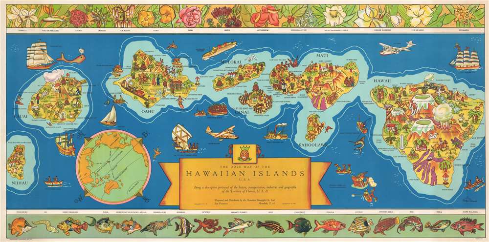
The Dole Map of the Hawaiian Islands U.S.A. Being a descriptive portrayal of the history, transportation, industries and geography of the Territory of Hawaii, U.S.A.
sold
- Digital Map Information
- Suitable for large format printing
- File Size: 38.85 MB
- File Type: ZIP / TIFF
- ICC color profile embedded
- Delivered instantly via download link
One of the most iconic pictorial maps of Hawaii from its territorial period. This 1937 Parker Edwards pictorial map of the Hawaiian Archipelago was issued by the Dole Pineapple Company to highlight the islands and Dole's business interests. Depicting the Hawaiian Islands of Hawaii, Maui, Kahoolawe, Lanai, Molokai, Oahu, Kauai, and Niihau, pictorial vignettes decorate each island and relate scenes of daily life, tourist 'attractions,' and Hawaiian history. On Hawaii, for example, each volcano is labeled with elevations provided. The lava flows from the many eruptions are illustrated as well. Pearl Harbor - not yet the site of an infamous attack - is labeled. Several aspects of Dole's operation in the islands, including pineapple plantations, Dole canneries, etc. also are depicted. The upper border includes drawings of Hawaiian flora. In contrast, the lower border highlights resident sea life. (more details)
Natural wonders and history.

A Pictorial Map of the United States.
sold
- Digital Map Information
- Suitable for large format printing
- File Size: 42.1 MB
- File Type: ZIP / TIFF
- ICC color profile embedded
- Delivered instantly via download link
This is a 1944 Elmer Jacobs pictorial map of the United States. Beautifully illustrated vignettes populate the continental U.S. from coast to coast and highlight aspects of American history, everyday life, and the country's natural beauty. Among these are illustrations of the Grand Canyon in Arizona, Mesa Verde in Colorado, and Crater Lake in Oregon. Historical references include illustrations of the Oregon Trail in Nebraska and Oregon, the Alamo in Texas, and the U.S. Capital in Washington, D.C. (more details)
From Boston to Cape Cod.
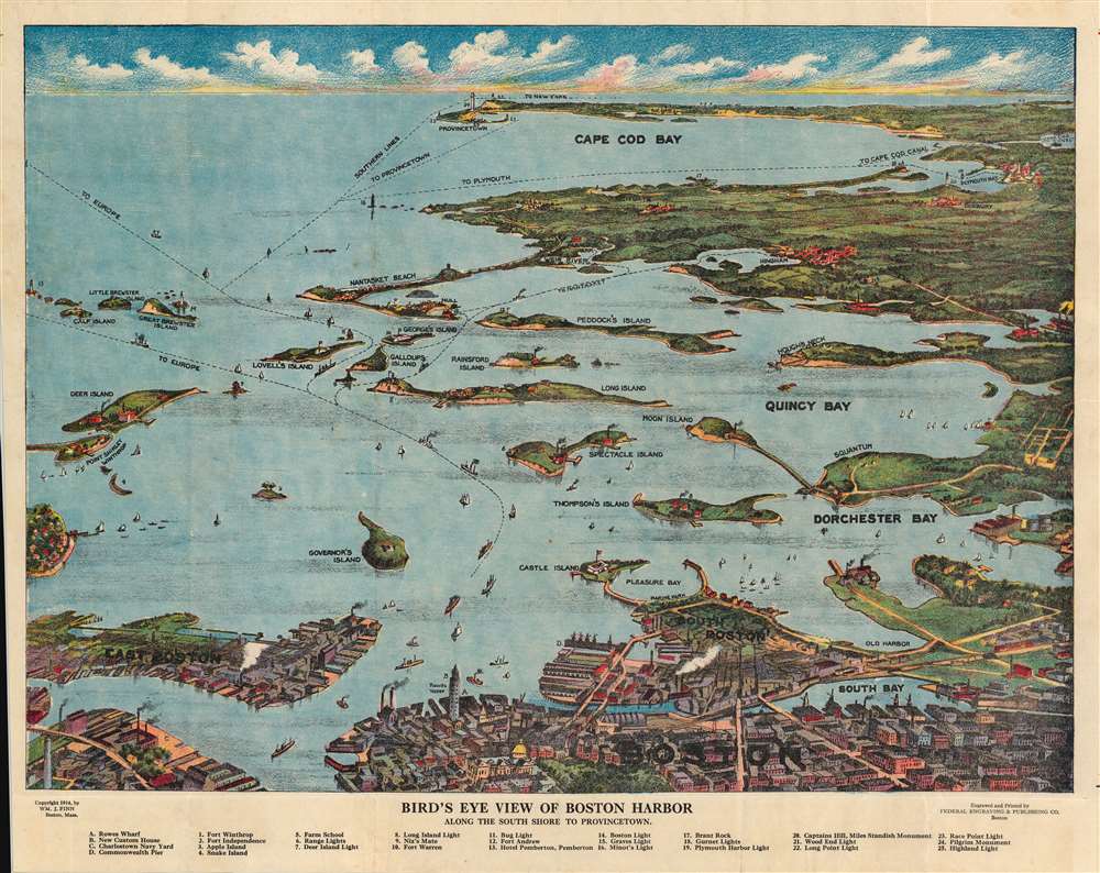
Bird's Eye View of Boston Harbor along the South Shore to Provincetown.
sold
- Digital Map Information
- Suitable for large format printing
- File Size: 54.87 MB
- File Type: ZIP / TIFF
- ICC color profile embedded
- Delivered instantly via download link
This is a 1914 William J. Finn chromolithograph bird's eye view of Boston Harbor from Boston to Provincetown. This view was drawn and published for sale to steamship passengers at the Union News stands at the Rowes Wharf steamship terminal, which serviced the Nantasket Line. All of Cape Cod Bay, Quincy Bay, and Dorchester Bay are depicted, including the communities of Boston, East Boston, South Boston, Dorchester, Quincy, and Hough's Neck, Mingham, Nantasket, Duxbury, Cohasset, and Scituate. Numerous islands in Boston Harbor are illustrated and labeled, including Moon Island, Spectacle Island, Thomson's Island, and Governor's Island. Ferry and steamboat lines are also labeled. Twenty-five locations throughout the region are numerically labeled and correspond with an index situated along the bottom border. Four additional locations are labeled alphabetically, which are also included in said index. (more details)
The Lookout Mountain Airline Highway from Cincinnati to Chattanooga.
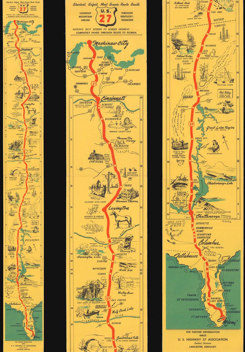
U.S. 27. Shortest, Safest, Most Scenic Route South. Nation's Best Border to Border Highway...Completely Paved Through Route to Florida.
sold
- Digital Map Information
- Suitable for large format printing
- Full resolution TIFF file
- ICC color profile embedded
- Delivered instantly via download link
This is a c. 1948 U.S. Highway 27 Association pictorial strip highway map of central United States. The map traces Highway 27 from Mackinaw City in Michigan south through Indiana, Ohio, Kentucky, Tennessee, Georgia, and Florida all the way to Miami. The area between Cincinnati and Chattanooga is given particular attention, with pictorial vignettes highlighting potential sites of interest: a thoroughbred horse farm near Lexington, Kentucky, the nuclear facility at Oak Ridge, Tennessee, and the site of the famous (or infamous) Scopes Monkey Trial, Dayton, Tennessee. (more details)
The most important Irish artist of the 20th century ... and W. B. Yeats' brother

A View of Pirate Island.
sold
- Digital Map Information
- Suitable for large format printing
- File Size: 8.23 MB
- File Type: ZIP / TIFF
- ICC color profile embedded
- Delivered instantly via download link
Created by Jack B. Yeats, this wonderful 1911 pictorial map of the fictitious Pirate Island. The island is populated by references to Yeats's life and literary works. The large ship in the bay, the Pasear, for example, is named after a ship he and his friends built in their backyard during his childhood in Ireland. Sligo, here a character meriting a house, was in fact Yeats's hometown in Ireland. The Pasear is also mentioned in Yeats's work The Little Fleet. Also, Theodore's House is a reference to The Little Fleet, which had a section devoted to a boat known as the 'Theodore'. (more details)
An attractively-engraved 16th century map of Transylvania.

Transsilvania.
sold
- Digital Map Information
- Suitable for large format printing
- DPI: 600
- File Size: 1.82 MB
- File Type: ZIP / TIFF
- ICC color profile embedded
- Delivered instantly via download link
This is a miniature edition of Abraham Ortelius' 1595 map of Transylvania, in what is now central Romania: the map shows the region northwest of Bucharest (the city, which had not yet become the capital, is not named: it is overshadowed by Târgoviște (here in an archaic Germanized spelling Tervisch), then the capital of Walachia.) The full-size map appearing in Ortelius' 1570 Theatrum Orbis Terrarum was the first atlas map of the region. It was sourced from a Vienna map published in 1566 by Johannes Sambucus, and engraved by the Venetian engraver Michael Tramezzini (that map is unacquirable). Ortelius' Theatrum, the first modern atlas, proved popular, and his full-size atlas was sufficiently successful that demand was recognized for a smaller, less-expensive option to the original work, and several miniature, so-called Epitome atlases of Ortelius' work appeared in the late 16th and early 17th centuries. (more details)
Sailing to Australia for the Victoria Gold Rush!
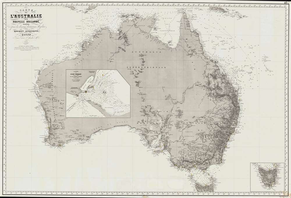
Carte de L'Australie ou Nouvelle Hollande, dressée d'aprés les derniers documents Anglais part Robiquet, Hydrographe, Paris.
sold
- Digital Map Information
- Suitable for large format printing
- File Size: 88.54 MB
- File Type: ZIP / TIFF
- ICC color profile embedded
- Delivered instantly via download link
A fine and exquisitely detailed 1863 first edition of Aimé Robiquet's privately published nautical chart or maritime map of Australia. Covering all of Australia, with Tasmania represented as an inset, this map was published to capitalize on navigation to Melbourne associated with the Victoria Gold Rush - hence the large inset of Port Phillip, the access point to Melbourne and the wealth lying just inland. Robiquet compiled this chart from the most up-to-date English sources, with several modifications and additions of his own to increase accuracy. (more details)
The Fifth Aliyah.
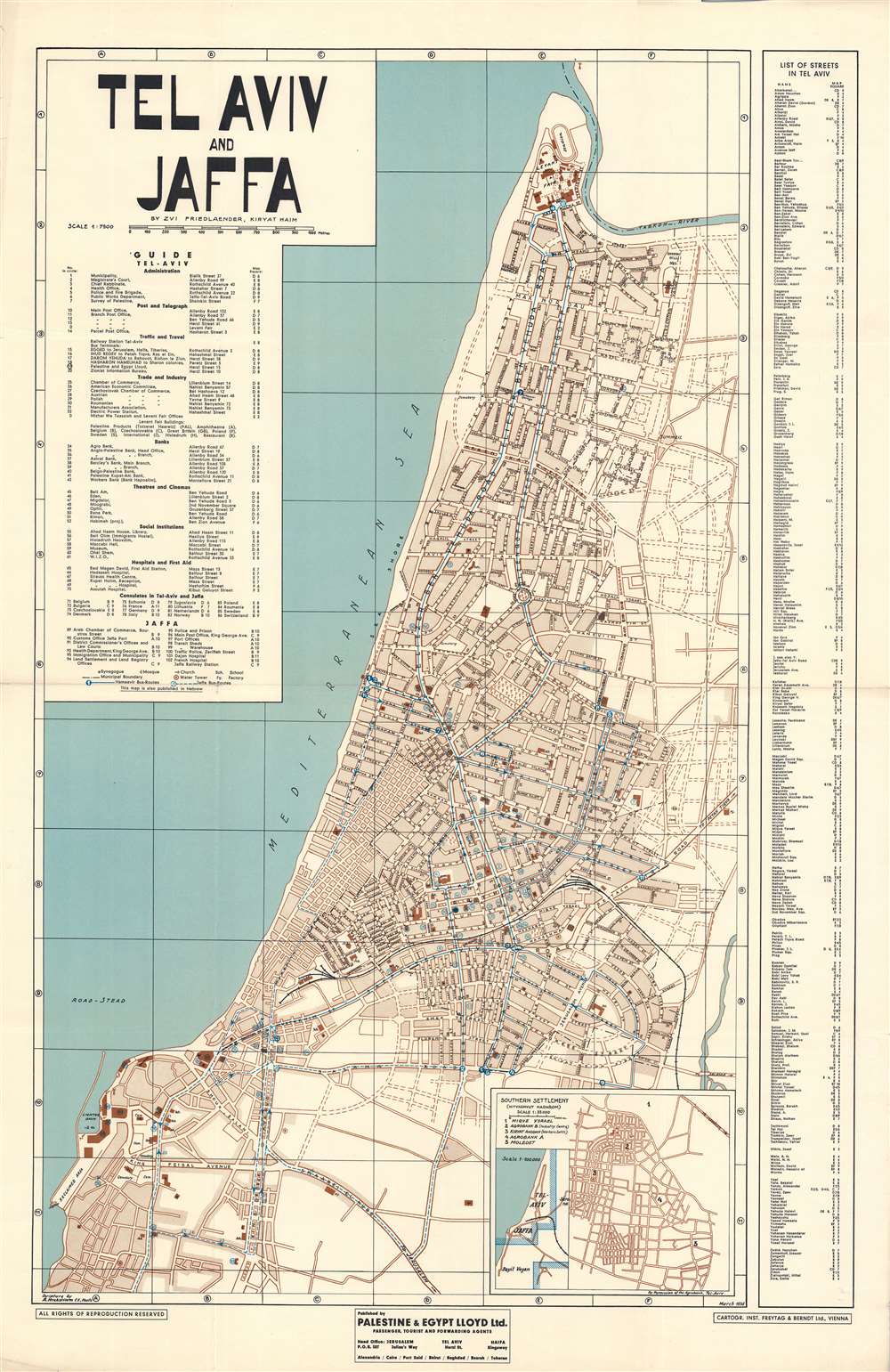
Tel Aviv and Jaffa.
sold
- Digital Map Information
- Suitable for large format printing
- File Size: 63.27 MB
- File Type: ZIP / TIFF
- ICC color profile embedded
- Delivered instantly via download link
This is an impressive large-scale 1936 map of Tel Aviv and Jaffa, Israel, by Zvi H. Friedlander, issued during the Fifth Aliyah (1929 - 1939). The map reflects Tel Aviv at the height of its Pre-War growth, when thousands of Jews, fleeing ever increasing antisemitism in Europe, made a new home in British Palestine. It also reflects the height of Bauhaus construction in Tel Aviv. (more details)
The celebrated 'Sarajevo Survival Map'.

1992 1993 Sarajevo 1994 1995.
sold
The internationally celebrated 'Sarajevo Survival Map', this is a 1996 FAMA pictorial map of Sarajevo, Bosnia and Herzegovina, illustrating the Siege of Sarajevo. The map depicts Sarajevo, resting in the valley of the Miljacka River. On the high ground surrounding the city, tanks, howitzers, and other artillery threaten the city and its inhabitants. The Siege of Sarajevo lasted from April 5, 1992 through February 29, 1996, a total of 1,425 days, making it the longest siege of a capital city in the history of modern warfare. (more details)
One of the earliest maps to illustrate Brooklyn after its 1855 consolidation.
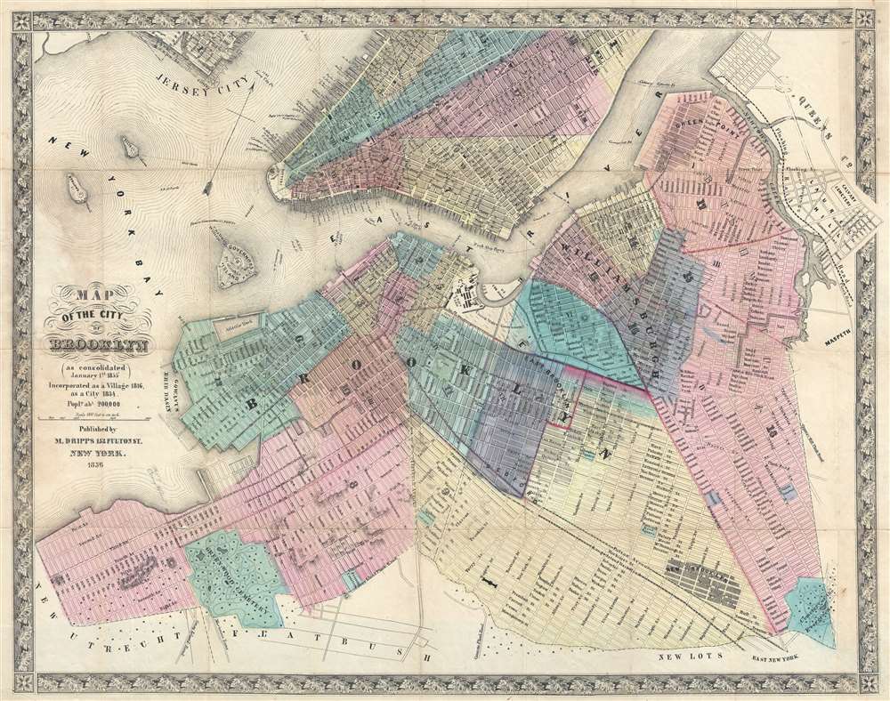
Map of the City of Brooklyn (as consolidated January 1st 1855).
sold
- Digital Map Information
- Suitable for large format printing
- File Size: 18.57 MB
- File Type: ZIP / TIFF
- ICC color profile embedded
- Delivered instantly via download link
This is a scarce 1856 map of Brooklyn, New York City by Matthew Dripps. The map follows the 1855 consolidation of Brooklyn, Williamsburg, Bushwick, and Greenpoint into a single city - as such it is one of the first maps to show Brooklyn much as we know it today - in fact, it is the earliest obtainable map we are aware of to do so. The map extends southwards roughly to 60th street, eastwards to Evergreen Cemetery, and northwards to Newtown creek. Parts of adjacent Manhattan (as far north as 40th Street), Queens (Long Island City), and Jersey City are illustrated. Many modern neighborhoods are not specifically named, such as Red Hook, Bedford Stuyvesant, Fort Green, etc. but are nonetheless present and identifiable. The Brooklyn Navy Yard is clearly represented with individual buildings recognizable. Sunset Park, although not identified, is apparent via the hachuring used to render elevation. Prospect Park, not yet conceived, is notably absent. (more details)
Foundational Nigeria map made at the beginning of Britain's most aggressive expansion into the region.
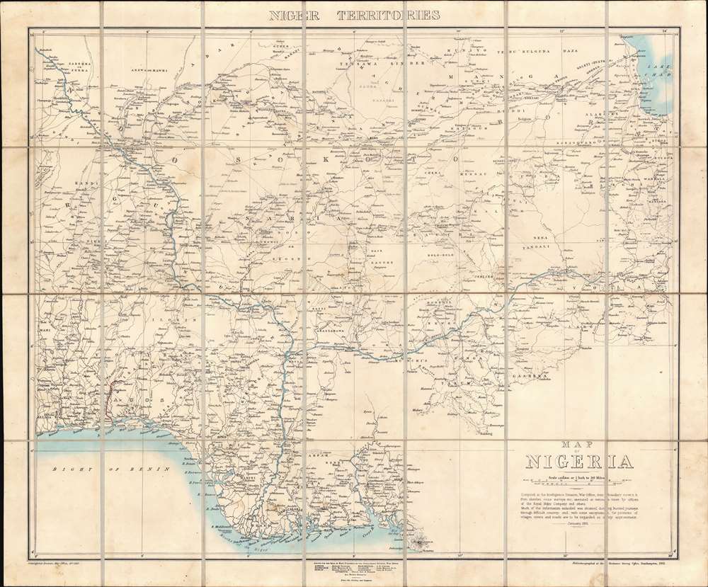
Map of Nigeria.
sold
- Digital Map Information
- Suitable for large format printing
- File Size: 39.32 MB
- File Type: ZIP / TIFF
- ICC color profile embedded
- Delivered instantly via download link
A rare 1901 first edition map of Nigeria issued by the Intelligence Division of the British War Office. The map was issued shortly after the British Crown took full control of Nigeria, establishing the Colony and Protectorate of Nigeria, and at the beginning of a period of aggressive expansion and conquest. Coverage extends from the Bight of Benin to Lake Chad, then south to Mount Cameroon. The map offers impressive detail - and not only along the well-traveled Niger, but also inland, naming hundreds of African cities and villages, as well as conflicting tribal and religious land claims. This is the first edition of the present map, although the basic template and cartographic data was reused until World War II (1939 - 1945), marking it as a foundational map. (more details)
Battle of Chickamauga by a Civil War veteran.

Chickamauga Battlefield.
sold
- Digital Map Information
- Suitable for large format printing
- File Size: 30.04 MB
- File Type: ZIP / TIFF
- ICC color profile embedded
- Delivered instantly via download link
This is an 1895 Joseph C. McElroy map of the Battle of Chattanooga, American Civil War (1861 - 1865). Federal (blue) and Confederate (red) lines on September 19 and September 20 are marked across the battlefield, with each unit identified by its commanding officer. Artillery batteries appear as cannons. As this map was created after the war for the Ohio Commission, monuments to various units are illustrated as well. (more details)
Hebrew Pictorial Map Game board.

[A Helicopter Journey.]
sold
An unusual c. 1955 Israeli boardgame in Hebrew by Amarna. The title transliterates to 'Tuil Behelicopter' or 'A Helicopter Journey.' The game combines a map game with a Hebrew version of Scrabble. Tokens are tiny helicopters. The game is complete with all original instructions, game cards, and tokens present. (more details)