
One of the earliest obtainable maps of Atlantic City.
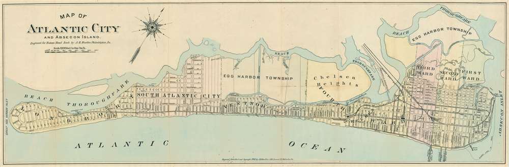
Map of Atlantic City and Absecon Island.
sold
- Digital Map Information
- Suitable for large format printing
- File Size: 20.75 MB
- File Type: ZIP / TIFF
- ICC color profile embedded
- Delivered instantly via download link
This is a rare 1902 August Henry Muller map of Absecon Island, including Atlantic City, issued in 1902. The map was published the year of Absecon's official incorporation as a city, making it one of the earliest obtainable separate issue maps of Atlantic City, Ventor, and Margate. The map is oriented to the northwest and covers all of Absecon Island from Great Egg Harbor Inlet to Absecon Inlet. The Boardwalk and Casino district of Atlantic City appears at right, with Youngs Ocean Pier, Auditorium Pier, Atlantic City Steel Pier, and Heinz Pier noted. Although long predating the casino period, Atlantic City in 1902 was still a hot spot for tourists. It offered luxurious grand hotels, the famous Boardwalk, sport fishing, spacious beaches, and golf. The Pennsylvania Railroad offered easy access connecting Atlantic City to both New York and Philadelphia. Quieter residential districts spread to the west, most offering commodious beach front real-estate that connects to the 'action' of Atlantic City via a convenient tram network. (more details)
2.5 years before the creation of Israel by the United Nations.
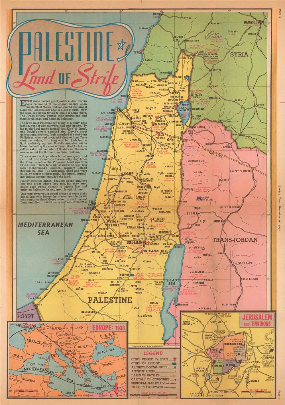
Palestine Land of Strife.
sold
- Digital Map Information
- Suitable for large format printing
- File Size: 18.83 MB
- File Type: ZIP / TIFF
- ICC color profile embedded
- Delivered instantly via download link
This is a 1945 Edwin Sundberg map of Palestine. The map depicts the region from Sidon to the Dead Sea and from the Mediterranean to Damascus. Throughout the region, cities and towns are labeled, and modern highways connect many of the major population centers. Red text marks important locations in Biblical history and battles fought in the region during the Crusades and World War I. Crosses mark cities visited by Jesus. An inset in the lower right corner details Jerusalem and its environs, including the divisions of the Old City. A second inset on the lower left illustrates Europe in 1938, the year before Adolf Hitler and Nazi Germany invaded Poland and ignited World War II. (more details)
Possible Allied invasion routes to Berlin.

Routes to Berlin.
sold
- Digital Map Information
- Suitable for large format printing
- File Size: 96.1 MB
- File Type: ZIP / TIFF
- ICC color profile embedded
- Delivered instantly via download link
This is a large, separately issued 1943 Robert M. Chapin, Jr. map Europe. Created for TIME, the map illustrates four possible Allied invasion strategies proposed by Colonel Conrad H. Lanza, U.S. Army (ret.) (1878 - 1963) in an article published in the June 1943 issue of the Field Artillery Journal. In this article, Colonel Lanza discussed potential Allied invasion points around continental Europe, although he did not attempt to predict where or when an invasion would take place. Each of Lanza's plans focused on the central Allied objective - capturing Berlin. Here, Chapin and TIME detail four of his proposed possibilities. The first involved an invasion of Norway between Oslo and Kristiansand, which would also necessitate landings on the western and northern Norwegian coasts are diversions. The Allies would then have a shorter distance to travel between Norway and Berlin but would have to combat large concentrations of enemy soldiers in a relatively small geographic area. This plan would also force the Allies to forcibly liberate Copenhagen, which would be a difficult task to say the least. Possible landings in Belgium and the Netherlands were also included by Chapin in this first possibility. Lanza's second proposal illustrated here involved invading southwestern France along the Spanish border from the Atlantic and Mediterranean coasts nearly simultaneously. The third option took advantage of Allied positions in Sicily, Sardinia, and Corsica to land troops in the northern Adriatic. Lanza proposed this option, it appears, because western Italy's terrain (the Alps and several major rivers) made invading Germany from there much more difficult. The final option depicted here is an Allied invasion of the continent through the Aegean Sea and Greece. Lanza pointed to the difficulties presented by German-held islands in the Aegean alongside the distances involved (on the order of 950 miles) and implied that this strategy was unlikely. (more details)
POW camps in Germany holding Americans.

Location of German Camps and Hospitals Where American Prisoners of War and Civilian Internees Are Held. based on information received to December 31, 1944.
sold
- Digital Map Information
- Suitable for large format printing
- File Size: 19.09 MB
- File Type: ZIP / TIFF
- ICC color profile embedded
- Delivered instantly via download link
This is a 1945 American National Red Cross map of German prison camps holding American prisoners of war (POWs) and civilian internees. Centered on eastern Germany, camps are labeled in striking red. Various symbols are used to mark camps for prisoners of war, airmen, officers, civilian internees, hospitals, and Marlag and Milag, where Navy and Merchant Marine personnel were imprisoned. Indexes along the left and right sides of the map list the names of each camp, the nearest town, and in in what square of the map grid they are located. These are divided into the same five categories, allowing viewers to quickly find the specific category in which they are interested. (more details)
Spectacular un-urban view of the utmost peculiarity.
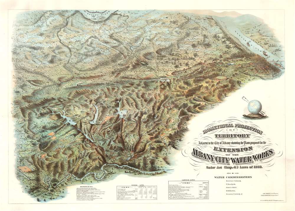
Isometrical Projection of Territory Adjacent to the City of Albany showing the Plans proposed for the Extension of the Albany City Water Works Under Act Chap. 42 Laws of 1868.
sold
- Digital Map Information
- Suitable for large format printing
- File Size: 84.17 MB
- File Type: ZIP / TIFF
- ICC color profile embedded
- Delivered instantly via download link
An oddity the likes of which we have never before seen, this is an innovative and stunning c. 1868 chromolithograph perspective bird's-eye view of the hills and waterworks to the southwest of Albany, New York. The view was drawn by the brilliant and ambitious German-American civil engineer Julius Caesar Laass. While city views were common after the American Civil War, it is unique to discover such a stunning large format chromolithograph illustrating an expansive, largely undeveloped, rural area. This view is thus both unique and innovative in this regard. (more details)
Supplying the Confederacy through the Blockade.

The Bahama Banks and Gulf of Florida, by Edmund Blunt.
sold
- Digital Map Information
- Suitable for large format printing
- Full resolution TIFF file
- ICC color profile embedded
- Delivered instantly via download link
A scarce, detailed, and highly attractive 1847 blueback-style nautical chart or maritime map of Florida and the Bahamas by Edmond Blunt and his sons E. and G. W. Blunt featuring notes and annotations suggestive of use by a Confederate blockade runner. The map offer unique insight into the supply line and trade routes of the Confederacy during the American Civil War. The chart covers Florida from 29°37' N, or, roughly speaking, from the latitude of Lake George south past the Florida Keys (then called the Florida Reef), as far as Cuba and from the longitude of Cape St. George eastwards to include the Bahama Islands. It offers limited inland detail but a fine mapping of coastal regions and countless depth soundings, especially around Tampa Bay, the Florida Keys, and throughout the Bahama Banks - a notoriously dangerous area for ships even with such a fine chart as this. Twelve shore profiles decorate the upper right quadrant. (more details)
South Sea whaling.

[South Pacific]
sold
- Digital Map Information
- Suitable for large format printing
- Full resolution TIFF file
- ICC color profile embedded
- Delivered instantly via download link
A rare 1825 James Norie blueback nautical chart or maritime map of the South Pacific with notations from a whaling voyage undertaken between 1855 and 1856. The chart, a composite of three charts joined by the original owner, covers from Borneo and Australia to South America and The Falkland Islands. (more details)
Beautiful, Historical Perspective View of Paris.

Paris Wie wie solche Ao. 1620 im Wessen gestanden.
sold
- Digital Map Information
- Suitable for large format printing
- Full resolution TIFF file
- ICC color profile embedded
- Delivered instantly via download link
This is a 1655 Caspar Merian bird's eye view of Paris, France. It appeared in Merian's Topographiae Gallae,, published in Frankfurt in 1655. The view is oriented to the north-east, looking up the Seine towards Notre Dame (at center). Boats can be seen plying the river (whose direction of flow is indicated with arrows.) The walled city has 290 of its principal structures numbered to a key which appeared in the text.* The title of the view indicates that it portrays Paris 'as it stood in 1620,' perhaps in order to imply it was composed by the elder Merian to accompany his famous panorama which was executed in and around that time. This was misleading on Caspar's part: this view is in fact a reduced and embellished version, not of a Merian plan of 1615, but the 1635 edition Melchior Tavernier's bird's eye view of Paris. The Tavernier lacks Merian's decorative flourishes: the coats-of-arms of Paris and of France; the figures in the garb of Parisians of various stations depicted in the lower left; and the helpfully-placed compass shown in the lower right-hand corner of the view.
*the first leaf of the text list is present with the map, with the remainder present in reproduction. (more details)
*the first leaf of the text list is present with the map, with the remainder present in reproduction. (more details)
Beautiful, Minutely Detailed Plan of Paris.
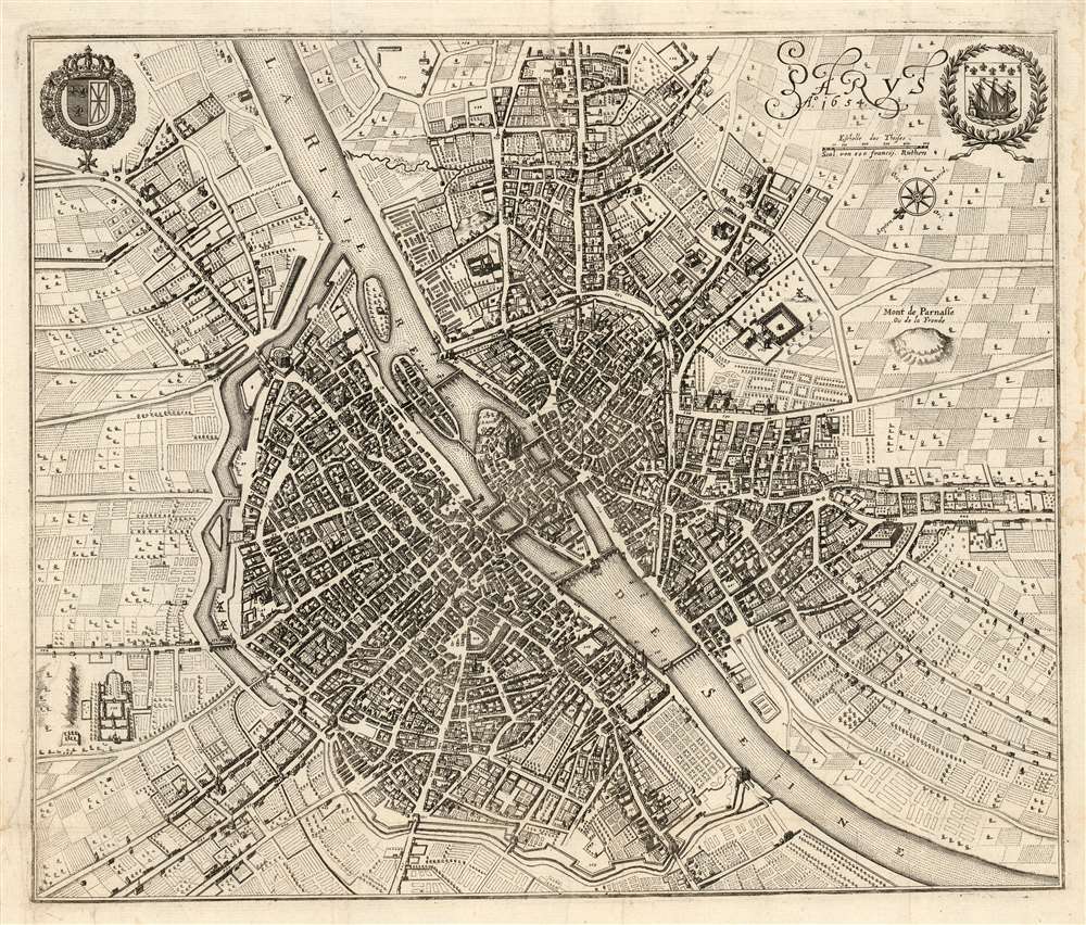
Parys Ao. 1654.
sold
- Digital Map Information
- Suitable for large format printing
- Full resolution TIFF file
- ICC color profile embedded
- Delivered instantly via download link
This is a 1655 Caspar Merian plan, or map of Paris, France. It appeared in Merian's Topographiae Gallae, published in Frankfurt in 1655. The plan is oriented to the south-east, centered on the Île de la Cité and Notre Dame Cathedral. The younger Merian includes in the upper corners the coats-of-arms of Paris and of France. The walled city has 793 streets, parks, and principal structures numbered to a key which appeared in the text, and which is included in full with this plan (three leaves, double-sided letterpress.) The title of the view implies that it portrays Paris 'in 1654,' and indeed it is a faithful reproduction of the four-sheet (and all-but unobtainable) Boisseau Plan général de la ville, cité, université, isles et faubourgs de Paris, which was not published until 1657 despite being dated 1648. (more details)
The first separate map of any Southeast Asian island to be based on actual observation.' - Suarez
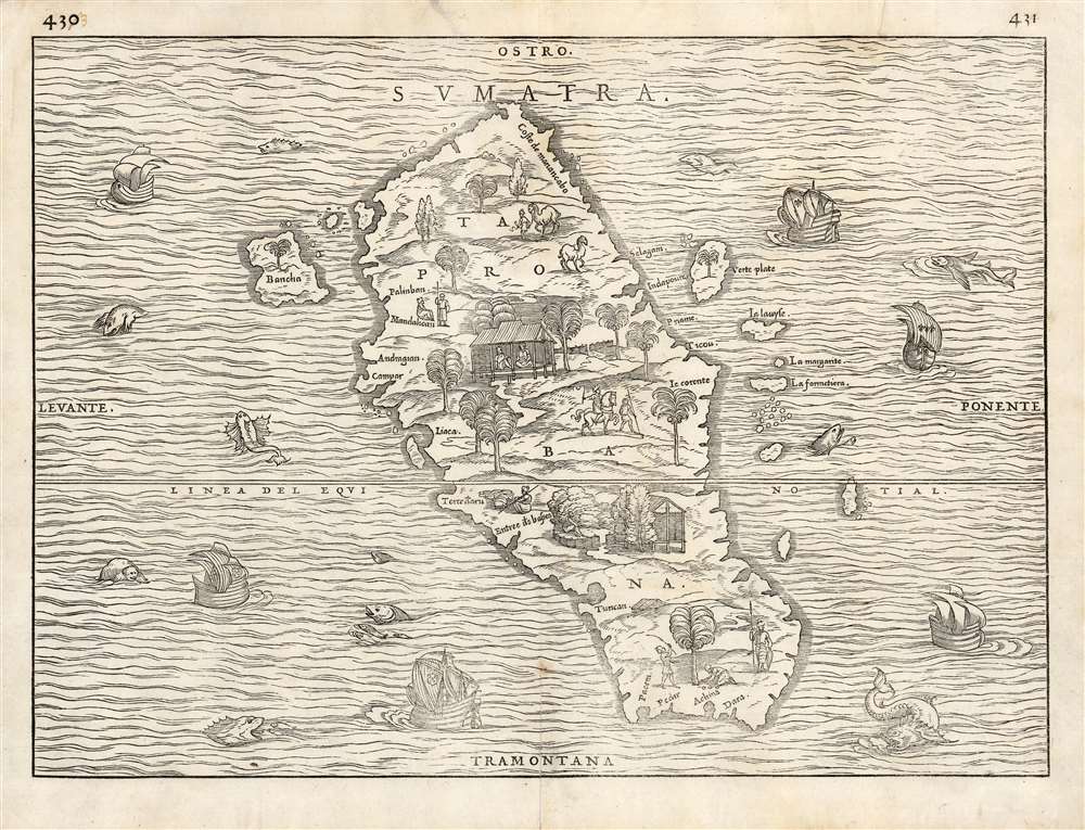
Sumatra Taprobana.
sold
- Digital Map Information
- Suitable for large format printing
- Full resolution TIFF file
- ICC color profile embedded
- Delivered instantly via download link
This is the seminal 1556 Giovanni Battista Ramusio map of Sumatra, 'the first separate map of any Southeast Asian island to be based on actual observation' (Suarez) and one of the first European maps to focus narrowly on so remote a part of the world. It appeared in Ramusio's i>Navigationi et Viaggi, the first collection of explorers' first-hand accounts of their travels. The source for this particular map came from the reports of Jean and Raoul Parmentier, who in 1529 ran the Portuguese blockade and attempted to compete with that power on behalf of the French by setting up a trading post at the Sumatran port of Ticon. It didn't work out - the Parmentier brothers died of fever, and only one ship of the expedition returned to France. The French saw no advantage in following up on this failure.
The woodcut, nonetheless represents the first glimpse in print of any specific Southeast Asian island, and this alone would make it desirable. It is moreover a very attractively executed woodcut: the sea around the island teems with fish, sea monsters, and ships - some of these bearing the Portuguese arms, and some flying the fleur de lis, alluding to the map's political context. There is also an element of Ramusio perhaps egging on his French audience, suggesting that whatever the Portuguese have found, the French ought to be able to take.
The map of the island is the first to entirely abandon Ptolemy's depiction of Taprobana, and along with Münster is among the first to associate the placename Taprobana definitively with Sumatra rather than Ptolemy's conflation of the place with Sri Lanka. It is moreover also the first map to approach an accurate outline of Sumatra, showing river inlets and bays on the coastline realistically. The island's inland features are presented pictorially, showing trees, dwellings, animals and people - men leading horses and camels, armed soldiers, men on horseback, and others harvesting coconuts. The variety and specificity of the depicted denizens suggest the presence of, and the author's familiarity with, organized social structures on Sumatra: an indication that here was not an uncivilized place, (like Ramusio's demon-haunted map of Canada), but somewhere one could go to do business. (more details)
The woodcut, nonetheless represents the first glimpse in print of any specific Southeast Asian island, and this alone would make it desirable. It is moreover a very attractively executed woodcut: the sea around the island teems with fish, sea monsters, and ships - some of these bearing the Portuguese arms, and some flying the fleur de lis, alluding to the map's political context. There is also an element of Ramusio perhaps egging on his French audience, suggesting that whatever the Portuguese have found, the French ought to be able to take.
The map of the island is the first to entirely abandon Ptolemy's depiction of Taprobana, and along with Münster is among the first to associate the placename Taprobana definitively with Sumatra rather than Ptolemy's conflation of the place with Sri Lanka. It is moreover also the first map to approach an accurate outline of Sumatra, showing river inlets and bays on the coastline realistically. The island's inland features are presented pictorially, showing trees, dwellings, animals and people - men leading horses and camels, armed soldiers, men on horseback, and others harvesting coconuts. The variety and specificity of the depicted denizens suggest the presence of, and the author's familiarity with, organized social structures on Sumatra: an indication that here was not an uncivilized place, (like Ramusio's demon-haunted map of Canada), but somewhere one could go to do business. (more details)
The Golden Age of Hollywood.

A slightly cockeyed map of that slightly cockeyed community Hollywood executed by that slightly cockeyed topographer...
sold
- Digital Map Information
- Suitable for large format printing
- File Size: 31.53 MB
- File Type: ZIP / TIFF
- ICC color profile embedded
- Delivered instantly via download link
This is a 1937 John. Groth pictorial map of Hollywood, California. Hollywood's glitz and glamour abound, with movie studios, such as Universal, 20th Century Fox, M.G.M., R.K.O., Warner Brothers, United Artists, Columbia, and Paramount, all vying for the viewer's attention. Radio stations, including N.B.C. and K.N.X., attempt to distract the viewer from the movie studios. Buses full of people travel Hollywood's roads, which are all labeled. Large crowds of people congregate around Cathay, at the American Legion Stadium, and the Santa Anita Racetrack. High society clubs and eateries, such as the Clover Club, Victor Hugo, the Beverly Wilshire, and Perino's. Groth contrasts Hollywood's wealth with windows into its obvious poverty, personified by Chinese laborers working near M.G.M. and migrants selling fruits and vegetables walking the streets next to the city's fashionable movie stars. (more details)
Soviet map of Cuba published during the Cuban Missile Crisis.

КУБА. / CUBA.
sold
This is a 1962 Soviet Department of Geodesy and Cartography map of Cuba published the year of the Cuban Missile Crisis - thus one of the few published maps to capture this ephemeral moment from the Soviet perspective. Printed in the Soviet Union and with all text in Russian, a political and topographic map occupies the majority of the sheet. Cities and towns appear throughout the island, including Havana, Matanzas, Cardenas, and Santiago. Roads and railroads are illustrated, along with rivers, mangroves, and swamps. Anchors mark ports and dashed lines connect them and distances between them are noted. An inset in the upper right quadrant details Cuba economically and highlights Cuban industries, including metalworking, oil refining, and textiles. Special attention is paid to mining activities, which extract iron ore, oil, copper, chromium, nickel, and cobalt, among other metals. A second inset of the Caribbean region, depicting from the southern United States to northern South America, occupies the lower left corner and situates Cuba regionally. (more details)
'An iron snake will cross from the lake of salt to the lands of the Great Lake.' - ancient Kikuyu prophecy
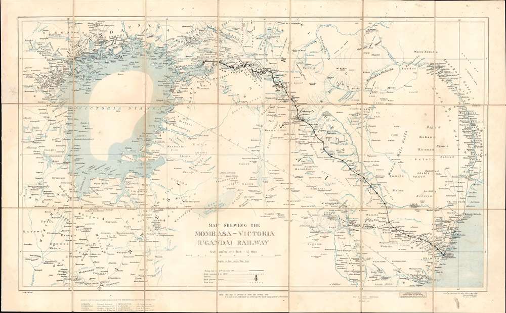
Map Shewing the Mombasa-Victoria (Uganda) Railway.
sold
- Digital Map Information
- Suitable for large format printing
- Full resolution TIFF file
- ICC color profile embedded
- Delivered instantly via download link
A rare and significant 1903 War Office 'Scramble for Africa' map illustrating the course of the Mombasa-Victoria Railway. Generally known as the Uganda Railroad, for its destination, the line is marked here running through Kenya from the Indian Ocean, through Nairobi, to the Lake Victoria port of Kisumu, Uganda. The map's coverage extends from the western shores of Lake Victoria to the Indian Ocean and the Tana River, embracing the heart of modern Kenya. Mount Kilimanjaro is named and connected to the railroad via an overland trade route from the stop of Voi. Beyond the railroad route, the map names countless villages and focuses on inland waterways. The border with rival German East Africa (Tanzania) is noted, underscoring the significance of the completed railroad to strategic control of the region. (more details)
Siege of Petersburg including the Battle of Five Forks, forcing the retreat of the Army of Northern Virginia.

Petersburg and Five Forks.
sold
- Digital Map Information
- Suitable for large format printing
- File Size: 64.72 MB
- File Type: ZIP / TIFF
- ICC color profile embedded
- Delivered instantly via download link
This is an 1867 John Weyss and Nathaniel Michler map of Petersburg and Five Forks, Virginia illustrating the Siege of Petersburg during the American Civil War (1862 - 1865). The map depicts the region from Five Forks to Prince George Court House and from the river road north of the Appomattox River to Malone's Bridge on Rowanty Creek. (more details)
A fascinating map celebrating nautical Massachusetts.

Map of Romantic Boston Bay and Cape Cod The Land Of Our Pilgrim Forefathers.
sold
- Digital Map Information
- Suitable for large format printing
- Full resolution TIFF file
- ICC color profile embedded
- Delivered instantly via download link
A charming 1944 pictorial map of Boston Bay Cape Cod and its towns, created by New England author and historian Edward Rowe Snow. A lover of all things piratical and nautical, Snow names the towns of coastal Massachusetts and Cape Cod with little fanfare, but luxuriates in his depictions of lighthouses, ships, shipwrecks, and whales. The shipwrecks are not generic, but specific, named ships ranging from the Pirate ship 'Whidah' (Whydah Gally, a slaver and pirate ship sunk in 1717) to Submarine S-4 (SS-109, a U.S. Submarine sunk in 1927). In addition to the abundance of wrecks, Snow notes many scenes of New England history, mostly of the sort calculated to instill patriotism in the hearts of the young audience for whom this map was intended. Notes such as 'John Smith Fought Indians Here 1614' 'the Home of Daniel Webster' and 'The American Army of Two' and 'The Tea Party' abound. (more details)
Pirate gold and buried treasure.

The Virgin Islands.
sold
This is a c. 1960 G. Hoyt serigraph pictorial map of the Virgin Islands. Hoyt's playful map depicts parts of the U.S. Virgin Islands and the British Virgin Islands, including St. John, Tortola, and Virgin Gorda. The Sir Francis Drake Channel, Salt Island Passage, the Winward Passage, The Narrows, and Pillsbury Sound appear. The overall motif evokes the bygone era of pirates and privateers, sacking ships for their wealth, and then burying it in great chests. Two large sailing ships ply the waters of the Caribbean Sea, and the Atlantic Ocean and cannons adorn the top right and left corners. Spanish doubloons decorate the bottom border. A treasure chest, a cutlass, and an anchor in the lower right corner suggest both the great wealth and violence associated with piracy. (more details)
Moscow's famous buildings, including the Kremlin and the Bolshoi Theatre, in profile.

Москва ПАНОРАМНЫЙ ПЛАН ЦЕНТРАЛЬНОЙ, ЧАСТи ГОРОДА. / Moscow PANORAMIC PLAN OF THE CENTRAL PART OF THE CITY.
sold
This is a 1975 Rabochiy Publishing pictorial city plan or map of Moscow, Russia. Centered on the Kremlin, numerous buildings throughout the city are illustrated in profile. St. Basil's Cathedral, the Bolshoi Theatre, the Cathedral of Christ the Savior, the Kotelnicheskaya Embankment Building, and the State Historical Museum are among these famous sites. Pictorial symbols mark museums and exhibitions, theaters and concert halls, cinemas, monuments, 'wedding palaces', hotels, and athletic facilities. Red circles with the letter 'M' inscribed in them highlight Moscow's many subway stations. In all, 421 locations throughout central Moscow are numerically identified and correspond with an index on the verso. (more details)
A Cartographic Historical Digest of Casco Bay.

Birds Eye View of Casco Bay: Portland, Maine and Surroundings.
sold
- Digital Map Information
- Suitable for large format printing
- File Size: 37.03 MB
- File Type: ZIP / TIFF
- ICC color profile embedded
- Delivered instantly via download link
This is a beautiful 1950 bird’s eye-view map of Casco Bay, Portland, Maine. It is the last edition of the George Walker view of the same title, issued in 1906. The view covers Casco Bay, an inlet of the Gulf of Maine on the southern coast of Maine, from Port Elizabeth and South Portland with Rangeley Lakes and Mount Washington in New Hampshire on the horizon. The city of Portland is beautifully rendered. Throughout, the map notes towns, islands, capes, points, and a few other topographical features. The bustling bay is shown full of ships and ferries traveling between its various islands and cities. As distinct from the original 1906, the title of this edition has been moved from the bottom of the map to the top, and the bottom has been filled with a tour of the region marking such highlights as John Smith's visit in 1614, a hiding spot of Captain Kidd's treasure, and the excellent hotel and cottage accommodations on the principal islands. (more details)
Pirate fun!
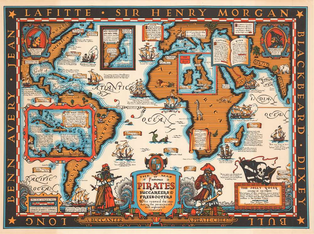
The Map of Famous Pirates Buccaneers and Freebooters who roamed the seas during the seventeenth and eighteenth centuries.
sold
- Digital Map Information
- Suitable for large format printing
- File Size: 32.61 MB
- File Type: ZIP / TIFF
- ICC color profile embedded
- Delivered instantly via download link
This is a 1938 Darby Harbold pictorial map of the world romanticizing the age of global piracy. The map celebrates the 'luminaries' of the era, including Blackbeard, Jean Lafitte, and Samuel Burgess. Pirate ships attack and conquer vessels on the open ocean throughout the world and then take their 'booty' and either bury it (banners proclaiming sites of buried treasure appear all over the world) or sell it. Short histories of pirate exploits dot the map and provide some understanding of the era's most successful brigands. Also, Harbold comments (in passing) on the different names given to pirates, such as 'buccaneers,' 'corsairs,' 'rovers,' and 'freebooters.' Harbold references the controversy surrounding Captain William Kidd, pirate or pirate-hunter? Her short text states that some believe Kidd to have been unjustly accused of being a pirate because he threatened the business interests of wealthy English citizens. Nonetheless, Kidd was tried and convicted of piracy and executed. Perhaps this episode suggests that piracy is all in the eye of the beholder as it were, and is not as black and white as history suggests. (more details)
The USA bullies a little boy.

Carte de la Guerre Hispano-Américaine.
sold
- Digital Map Information
- Suitable for large format printing
- File Size: 31.79 MB
- File Type: ZIP / TIFF
- ICC color profile embedded
- Delivered instantly via download link
This is an 1898 anti-American propaganda map of the eastern United States and the Caribbean published during the Spanish-American War (April 21, 1898 - December 10, 1898) by the 'then' radical-socialist French newspaper La Depêche. The map illustrates the eastern United States, the Caribbean, and, in a large inset, the Philippines - thus detailing all major theaters of engagement. In the Atlantic, there is a striking vignette engraving a very worried looking Alphonso XIII, the boy King of Spain. Alphonso XIII was King of Spain from birth and in this illustration is just 12, as the map underscores by printing his birth date. The anti-American message is subtle but clear - look at the big bad USA bullying this poor little boy. (more details)