
Illustrates over one hundred different flags from around the world.

A Chart of National Flags.
sold
- Digital Map Information
- Suitable for large format printing
- DPI: 600
- File Size: 25.56 MB
- File Type: ZIP / TIFF
- ICC color profile embedded
- Delivered instantly via download link
This is an 1851 Henry Bill chart of national flags. Illustrating one hundred five different flags, nations, city-states, companies, and other entities are represented here. The five largest flags, one in each of the four corners and a fifth situated at top center, ... (more details)
The first accurate map of the Adirondacks.
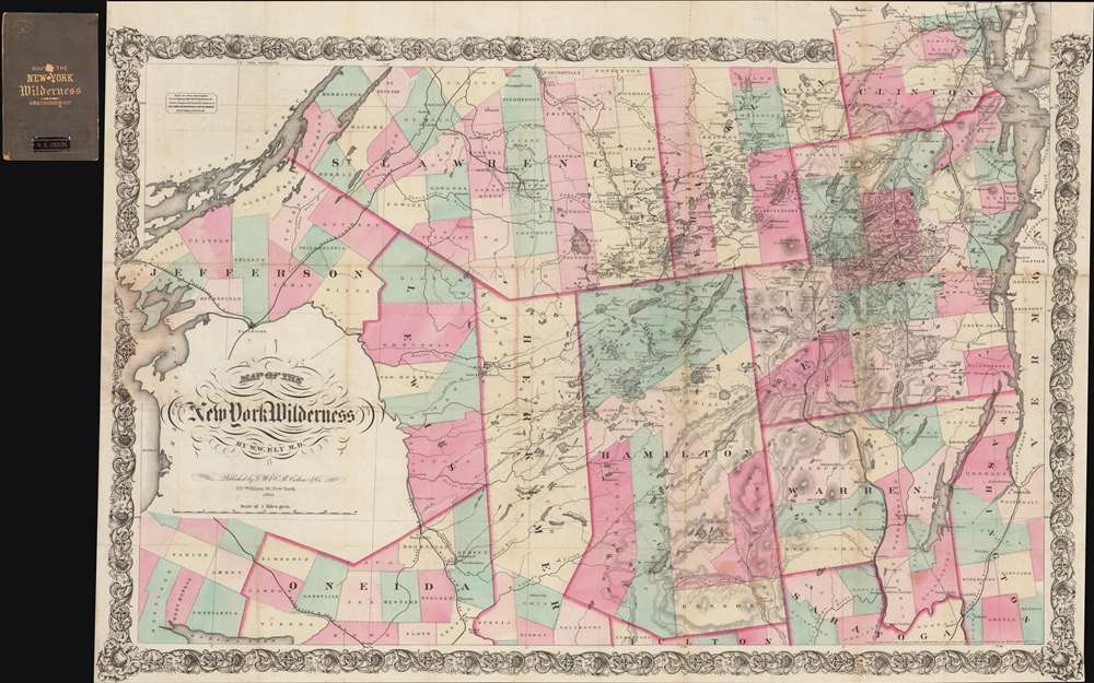
Map of the New York Wilderness.
sold
- Digital Map Information
- Suitable for large format printing
- File Size: 70.01 MB
- File Type: ZIP / TIFF
- ICC color profile embedded
- Delivered instantly via download link
A rare 1869 edition of William Watson Ely's map of New York's Adirondack Mountains - this is the first large scale map of the Adirondacks. The map covers from the St. Lawrence River to Lake Champlain inclusive of the counties of St. Lawrence, Clinton, Essex, Hamilton, Warren, Herkimer, Jefferson, Lewis, and Oneida. The whole is surrounded by an elaborate decorative vine motif border. (more details)
Highlights British possessions in the Atlantic World.
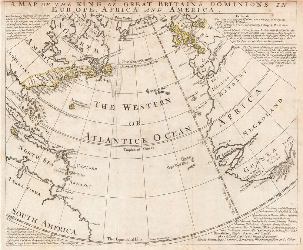
A Map of the King of Great Britain's Dominions in Europe, Africa, and America.
sold
- Digital Map Information
- Suitable for large format printing
- File Size: 37.9 MB
- File Type: ZIP / TIFF
- ICC color profile embedded
- Delivered instantly via download link
This is a c. 1740 pre-French and Indian War Emmanuel Bowen map of the British Empire in Europe, Africa, and the Americas, or what historians refer to as the Atlantic World. Beautifully engraved and highly informative, the map centers on the Atlantic Ocean, with the Americas on the left and Europe and Africa on the right. Yellow outlining is used to identify which parts of the world 'are now possessed by the King of Great Britain', including the American colonies that became the United States, numerous islands in the Caribbean, and a pair of duchies in modern-day Germany. Areas outlined in green were formerly controlled by the British crown. Colonies, settlements, islands, or countries, are identified throughout, several which are underlined, identifying it as a possession of the Great Britain. These include Gibraltar, Charles Town (Charleston, South Carolina), and Acra (Accra, Ghana), etc. Information concerning the map and the Empire is situated in the corners, including an explanation of how to read the map and details related to British possessions in Asia. (more details)
A view of San Francisco during the California Gold Rush.

San Francisco. 1850.
sold
- Digital Map Information
- Suitable for large format printing
- DPI: 600
- File Size: 11.02 MB
- File Type: ZIP / TIFF
- ICC color profile embedded
- Delivered instantly via download link
This is an 1850 Theodore Taylor Johnson view of San Francisco during the California Gold Rush. Conveying at once the city's frontier reality and its burgeoning populace, the number of buildings and ships at anchor in the bay make it obvious that the city's ... (more details)
Important French and Indian War issue of Bellin's influential Map of the Great Lakes. Probably the most decorative of the series.

Partie Occidentale de la Nouvelle France ou du Canada.
sold
- Digital Map Information
- Suitable for large format printing
- DPI: 600
- File Size: 22.1 MB
- File Type: ZIP / TIFF
- ICC color profile embedded
- Delivered instantly via download link
A rare and extremely influential 1755 map of the Great Lakes drawn by Jacques Nicholas Bellin. This map, which appeared in the 1755 issue of the Homann Heirs Atlas Major , depicts all five of the Great Lakes as well as the adjacent Indian lands and the ... (more details)
Tanner's world map depicting the routes of Captain Cook and other explorers.
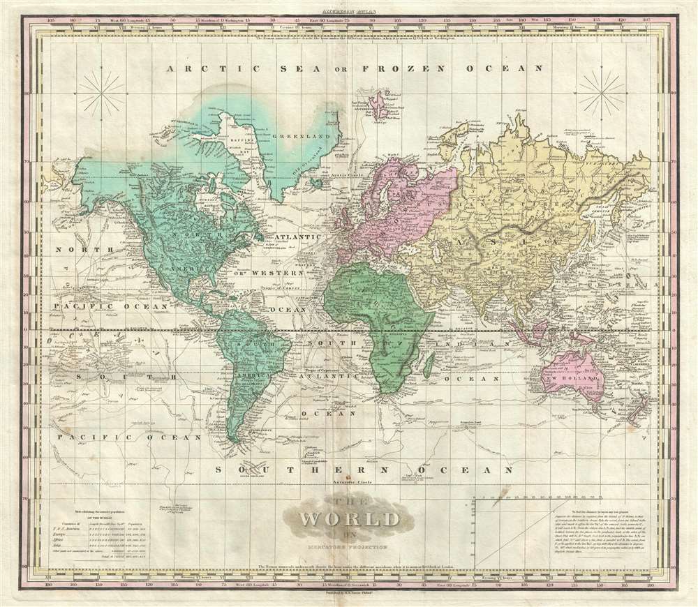
The World on Mercator's Projection.
sold
- Digital Map Information
- Suitable for large format printing
- Full resolution TIFF file
- ICC color profile embedded
- Delivered instantly via download link
This is an 1825 Henry Shenk Tanner world map on Mercator's projection. The map depicts six of the seven continents, excluding Antarctica, although the Antarctic Circle is noted. Curiously, the only continent not to be illustrated in its entirety is ... (more details)
A wonderful 18th century map of the southern Philippines.

Carte des Isles Philippines. Dressée sur la Carte Espagnole du R.P. Murillo de Velarde. 2e Feuille. Pour servir a l'Histoire Générale des Voyages.
sold
- Digital Map Information
- Suitable for large format printing
- DPI: 600
- File Size: 5.95 MB
- File Type: ZIP / TIFF
- ICC color profile embedded
- Delivered instantly via download link
This is a 1752 Jacques-Nicolas Bellin map of the southern Philippines including the islands of Leyte, Mindanao, Negros, Cebu, Palawan, and Samar. Beautifully engraved, the map depicts the region from Samar to Borneo and from Palawan to Mindanao. ... (more details)
A beautiful 18th century map of Iceland - known as the Land of Fire and Ice.

Carte de l'Islande, Pour Servir à la Continuation de l'Histoire générale des Voyages.
sold
- Digital Map Information
- Suitable for large format printing
- DPI: 600
- File Size: 11.68 MB
- File Type: ZIP / TIFF
- ICC color profile embedded
- Delivered instantly via download link
This is a 1759 Jacques-Nicolas Bellin map of Iceland. The map depicts the entirety of the island and divides it into four regions. Numerous rivers are illustrated, as are groups of mountains. Two ' villes episcopales ' are noted, Skalhol and ... (more details)
Grenville's map of Florida in rare English edition.

Granville's Railroad and Township Map of Florida.
sold
- Digital Map Information
- Suitable for large format printing
- File Size: 12.69 MB
- File Type: ZIP / TIFF
- ICC color profile embedded
- Delivered instantly via download link
An uncommon 1886 Charles Granville folding pocket map of Florida here in its first English edition. Covering all of Florida, the map divides the state into counties, with an index of place names appearing in the lower right. An inset at left center extends the map west as far as Alabama. The map names Miami and shows a number of railroads in central and norther Florida but predates Flagler's East Coast Florida Railway. Several of the canals proposed to drain the Everglades into Lake Okeechobee are also noted. (more details)
Extremely rare WWII map of Singapore using Japanese Occupation name Shonanto.

昭南島市街地圖 / Syonan-to City Street Map. [Singapore].
sold
- Digital Map Information
- Suitable for large format printing
- File Size: 14.9 MB
- File Type: ZIP / TIFF
- ICC color profile embedded
- Delivered instantly via download link
A very rare unrecorded variant of the 1942 WWII (World War II) map of Singapore City and island. This is notably one of the few maps to use the ephemeral Japanese Occupation (1942-1945) term for Singapore, 'Syonan-to' (昭南島 ... (more details)
An important record of the Japanese-American experience.

North America. City of Los Angeles. / 北米加州ロスアンゼルス市略圖
sold
- Digital Map Information
- Suitable for large format printing
- File Size: 43.45 MB
- File Type: ZIP / TIFF
- ICC color profile embedded
- Delivered instantly via download link
A rare 1929 Japanese language map of Little Tokyo, Los Angeles published by Pacific Printing for the Olympic Hotel. The recto features a detailed map of the Little Tokyo district. The map is oriented to the west and centered on the intersection of San Pedro Street and East 9th Ave. Above the map proper is an illustration of the grand Olympic Hotel, then the best Japanese-focused hotel in Los Angeles. The map is further surrounded by advertisements for Japanese owned business in the area, many of which are also noted on the map. The recto, or back of the map, features more advertisements and a general plan of Greater Los Angeles. (more details)
Garbutt return's the Underground Map to Beck's Values.

London Transport. Underground.
sold
- Digital Map Information
- Suitable for large format printing
- File Size: 82.02 MB
- File Type: ZIP / TIFF
- ICC color profile embedded
- Delivered instantly via download link
A c. 1972 large format map of the London Underground as drawn by Paul E. Garbutt made for in-station display. This map, or rather schematic transport diagram, is drawn on the c. 1930s Harry Beck model. In 1960, when the Victoria Line was introduced, the classic Beck map had to be redrawn. The job fell to publicity artist Harold Hutchison, who redesigned the Beck map, replacing Beck's curves with unpopular angles and square interchanges. The map was so unpopular, that in 1962 London Transit worker Paul E. Garbutt, again redesigned it, returning to the Beck style, but retaining some of Huchinson's ideas, including black rings for interchanges and lower-case text for non-interchange stations. Around this time Garbutt also introduced the distinctive bottle shape of the Circle Line which, years later, Absolute Vodka was able to leverage for some clever advertising. This version of the underground map was prepared in 1972 and includes plans to extend the Piccadilly Line to Hattan Cross and Heathrow Airport, a project that was not completed until 1977. (more details)
Bilingual German and English map of the region around Mount Everest.

Mahalangur Himal Chomolongma - Mount Everest.
sold
This is the first and most important modern map of the Mount Everest region. This extraordinary map was published in 1957 by the Deutscher Alpenverein (German Alpine Club) and Österreichischer Alpenverein (Austrian Alpine Club) based upon photogrammetric survey work conducted by Erwin Schneider during the 1955 Norman G. Dyrhenfurth Himalaya Expedition. The six-color chromolithograph map depicts the Khumbu, or the south (Nepalese) approach Mount Everest, which appears in the upper right, covering from Tsolatse to Baruntse and from Lingtren to Ama Dablam. The detail throughout, down to stone walls and tiny paths, is an extraordinary representation of the Khumbu's complex terrain. Topography is represented by contours at 20-meter intervals with every 100 meters emphasized. (more details)
A gorgeous pictorial map of Africa featuring illustrations of African wildlife.

Afrika i bilder.
sold
- Digital Map Information
- Suitable for large format printing
- File Size: 48.65 MB
- File Type: ZIP / TIFF
- ICC color profile embedded
- Delivered instantly via download link
This is a stunning c. 1955 B. Lindblad pictorial map of Africa. The map depicts the region from the Atlantic Ocean to the Persian Gulf and the Indian Ocean and from Spain, Sicily, and Greece to the Cape of Good Hope. Beautifully illustrated, the incredible biodiversity of this vast continent is on full display. The relative prosperity of French Colonial Africa along the Mediterranean is highlighted by green hills, mountains, and buildings meant to denote cities. The ruins of Carthage are illustrated in Tunisia, as are the Pyramids at Giza in Egypt. The artist emphasized the life-giving power of the Nile River by making the river valley a blue and green channel through the brown wasteland of the Sahara. The nomadic lifestyle of the people living in the Sahara is shown, complete with camels and horses.
Sub-Saharan Africa is verdantly colored, with West Africa featuring a native village and locals fashioning ivory into trinkets. The wildlife of the region is, of course, the map's focus. Elephants, gazelles, gorillas, leopards, hippos, lions, and giraffes are only a few of the species illustrated. The duality of native existence up against modern technology and the constant drive to exploit Africa's seemingly infinite natural resources also take center stage, with a large tractor and a diamond mine drawn next to local villages and livestock.
The Middle East and the Arabian Peninsula are also illustrated in the upper right corner, complete with an illustration of the Great Mosque of Mecca in profile. Oil derricks are depicted along the Persian Gulf, along with a tanker plying the Gulf's waters to take the 'black gold' to market. (more details)
Sub-Saharan Africa is verdantly colored, with West Africa featuring a native village and locals fashioning ivory into trinkets. The wildlife of the region is, of course, the map's focus. Elephants, gazelles, gorillas, leopards, hippos, lions, and giraffes are only a few of the species illustrated. The duality of native existence up against modern technology and the constant drive to exploit Africa's seemingly infinite natural resources also take center stage, with a large tractor and a diamond mine drawn next to local villages and livestock.
The Middle East and the Arabian Peninsula are also illustrated in the upper right corner, complete with an illustration of the Great Mosque of Mecca in profile. Oil derricks are depicted along the Persian Gulf, along with a tanker plying the Gulf's waters to take the 'black gold' to market. (more details)
First edition of Camy's humerous pictorial map of Alaska.
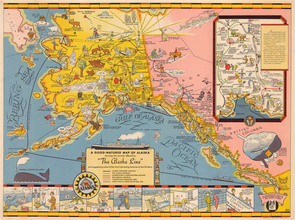
A Good-Natured Map of Alaska, showing the services offered by 'the Alaska Line' and suggesting some of the most interesting features of the Territory.
sold
- Digital Map Information
- Suitable for large format printing
- File Size: 11.7 MB
- File Type: ZIP / TIFF
- ICC color profile embedded
- Delivered instantly via download link
A delightful 1934 first edition pictorial map of Alaska drawn by Edward Camy to promote 'The Alaska Line'. Drawn in the style of Jo Mora, Camy's map covers most of Alaska and parts of the Yukon and British Columbia as far south as Seattle. For a place that is shrouded in twilight for several months a year, this map is remarkably bright and sunny – no doubt an attempt by the Alaska Line to offset the image of Alaska as cold and dreary. Cartoonish vignette illustrations elaborate on Alaska's flora, fauna, culture, scenery, mineral wealth, and the activities that can be enjoyed there. The route of the steamship line is traced as it weaves around the islands near Sitka on its way to Valdez and Kodiak. Other routes go directly to Nome or island hop through the Aleutians. An inset map in the upper right quadrant offers travelers the option to disembark in Cordova and set out on an inland tour to Fairbanks, visiting Mount McKinley and Anchorage before re-embarking at Seward. A cartoon strip along the bottom of the map follows the adventures of two travelers as they dine, dance, sleep and play their way up the coast. A whale in the lower left is advertised as a 'portable geyser'. (more details)
Also known as the Battle of the Plains of Abraham, this battle was a key British victory in the French and Indian War.

An Authentic Plan of the River St. Laurence, from Sillery to the Falls of Montmorency.
sold
- Digital Map Information
- Suitable for large format printing
- DPI: 600
- File Size: 2.03 MB
- File Type: ZIP / TIFF
- ICC color profile embedded
- Delivered instantly via download link
This is a 1759 John Gibson map of the Battle of Quebec during the French and Indian War, the name for the North American theater during the 7 Years' War between Britain and France. Also known as the Battle of the Plains of Abraham, the map depicts the region from the sillery to Montmorency Falls and from Charlebourg to the Isle of Orleans (Isle d'Orléans). The blockading British fleet is illustrated in the St. Lawrence, while French encampments are labeled all along the river from Quebec City to the Montmorency Falls. The battle, which took place to the west of Quebec City, is illustrated by French and British battle lines. (more details)
Features a pictorial border consisting of illustrations of birds and plants native to North Carolina.
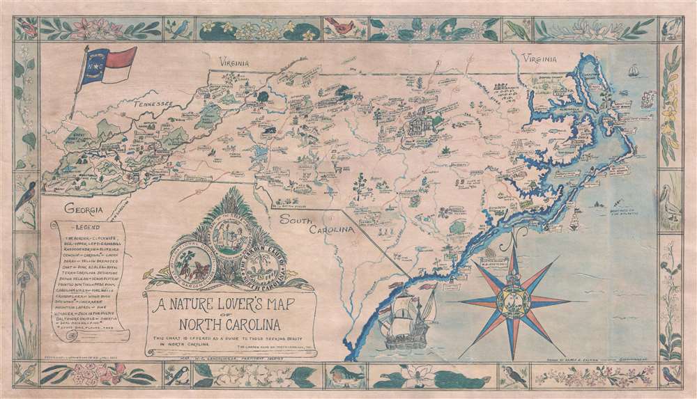
A Nature Lover's Map of North Carolina.
sold
- Digital Map Information
- Suitable for large format printing
- File Size: 22 MB
- File Type: ZIP / TIFF
- ICC color profile embedded
- Delivered instantly via download link
A striking and rare 1966 Grace Belknap Illman pictorial map of North Carolina. The map depicts all of North Carolina as well as adjacent parts of Georgia, Tennessee, Virginia and South Carolina. Cities, towns, points of interest, gardens, parks, and historical sites are illustrated pictorially. Flower shows and festivals are also noted, since this map was published by the Garden Club of North Carolina.
National parks and state parks throughout the state are also illustrated and labeled. Great sailing ships from the 17th or 18th century appear in the Atlantic off the Outer Banks, where several sinking ships highlight the 'graveyard of the Atlantic.' Kitty Hawk, where Orville and Wilber Wright made the first powered flight in human history, includes an illustration of the 'Wright Flyer'. The seals of the State of North Carolina, the National Council of State Garden Clubs, and the Garden Club of North Carolina are situated to the left of center, just above the title cartouche. The whole is surrounded by a pictorial border highlighting North Carolina's striking diversity of flora and fauna. (more details)
National parks and state parks throughout the state are also illustrated and labeled. Great sailing ships from the 17th or 18th century appear in the Atlantic off the Outer Banks, where several sinking ships highlight the 'graveyard of the Atlantic.' Kitty Hawk, where Orville and Wilber Wright made the first powered flight in human history, includes an illustration of the 'Wright Flyer'. The seals of the State of North Carolina, the National Council of State Garden Clubs, and the Garden Club of North Carolina are situated to the left of center, just above the title cartouche. The whole is surrounded by a pictorial border highlighting North Carolina's striking diversity of flora and fauna. (more details)
Detailed and gorgeous map of the Korean War - with unit insignia, manuscript notations, and a signature!

Pacific Stars and Stripes Map of the War.
sold
- Digital Map Information
- Suitable for large format printing
- File Size: 11.7 MB
- File Type: ZIP / TIFF
- ICC color profile embedded
- Delivered instantly via download link
This is a 1953 Pacific Stars and Stripes map of the Korean War. The map depicts the Korean peninsula from the Yalu River and the Tumen River to the Korea Strait and from the Yellow Sea to the Sea of Japan. Twenty-five different ... (more details)
Amusing pictorial map of the United States with its various legends and folklore.

Folklore and Legends of Our Country.
sold
- Digital Map Information
- Suitable for large format printing
- Full resolution TIFF file
- ICC color profile embedded
- Delivered instantly via download link
This is an appealing and colorful 1962 Esso pictorial map of the United States illustrated with our national folklore and legends. Recognizable figures include Paul Bunyan and his great Blue Ox, Long Jon Silver, Moby Dick, ... (more details)
A gorgeous map of the Maldives, known the world over for the spectacular beauty of its beaches and scenery.
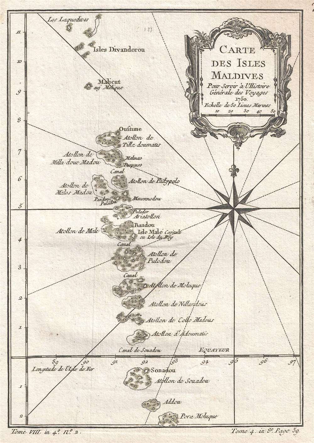
Carte des Isles Maldives. Pour Servir à l'Histoire Générale de Voyages.
sold
- Digital Map Information
- Suitable for large format printing
- Full resolution TIFF file
- ICC color profile embedded
- Delivered instantly via download link
This is a 1750 Jacques-Nicolas Bellin map of the Maldives, an nation situated in the Indian Ocean about six hundred miles southwest of the Asian continent. The map depicts the archipelago from Les Laquedives to Pora ... (more details)