
Bay Area Bioregionalism.
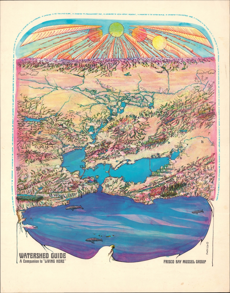
Watershed Guide A Companion to 'Living Here'.
$850.00
Acquire
A colorful view of the bioregion of San Francisco Bay, prepared in 1977 by the environmental activist organization Frisco Bay Mussel Group as a supplement to their publication Living Here. (more details)
Yosemite's El Capitan.
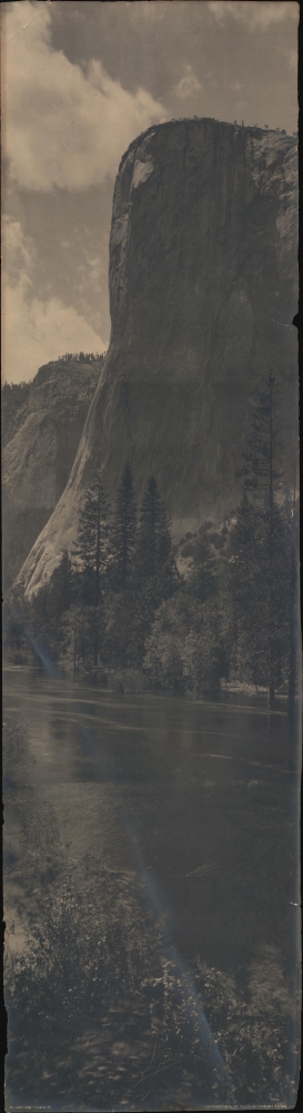
El Capitan, Yosemite.
$650.00
Acquire
- Digital Map Information
- Suitable for large format printing
- File Size: 8.38 MB
- File Type: ZIP / TIFF
- ICC color profile embedded
- Delivered instantly via download link
This is a 1906 Arthur C. Pillsbury panoramic photograph of the southeast face of El Capitan in Yosemite National Park, California. Measuring nearly a yard tall, El Capitan 3000-foot elevation towers above a stand of trees along the banks of the Merced River in the foreground. (more details)
First edition pictorial map Mount Desert Island.

Mount Desert Island Region of the Maine Coast.
sold
This is a rare first-edition 1941 Luther S. Phillips pictorial map of Mount Desert Island, Maine. It highlights one of the most popular tourist destinations on the eastern seaboard - Acadia National Park. Phillips was a local of Mount Desert Island, living most of his life in Northeast Harbor. His fun pictorial maps were popular with tourists and locals, enjoying a wide following. First editions of his works, as here, are now very scarce. (more details)
Vietnam War: A Viet Cong Battle Plan.

Trận chiến dấu chống cân của CBB II/d1 ngây 4/9/68 tai Phước Lâm. [Defense battle against raid by CBB II/d1 4/9/68 at Phước Lâm.]
sold
This is a Vietnam War Era Viet Cong manuscript map illustrating the defense of Phước Lâm, a commune in Long An province. (more details)
San Francisco's Late 19th Century Water System.

Map of San Francisco Showing the Water Service of Spring Valley Water Works.
sold
- Digital Map Information
- Suitable for large format printing
- File Size: 29.02 MB
- File Type: ZIP / TIFF
- ICC color profile embedded
- Delivered instantly via download link
A scarce and important 1894 Britton and Rey map of San Francisco highlighting the water system owned by the Spring Valley Water Works, arguably the most powerful monopoly in California at the time of publication. However, it was also facing public criticism and an insufficient supply of water for the city, prompting extremely ambitious plans in the following years. (more details)
Beautifully engraved miniature world map.
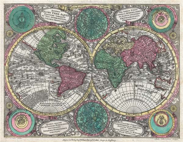
Diversi Globi Terr-Aquei Statione Variante et Visu Intercedente, Per Coluros Tropicorum Per Ambos Polos et Particul, Sphaerae Zenith in Planum Deleati Orthographici Prospectus.
sold
- Digital Map Information
- Suitable for large format printing
- DPI: 300
- File Size: 3.44 MB
- File Type: ZIP / TIFF
- ICC color profile embedded
- Delivered instantly via download link
A full-color c. 1762 double-hemisphere map of the world by Tobias Conrad Lotter. Published for the Atlas Minor, this is a small yet dense map, with the hemispheres surrounded by two celestial charts and four conflicting cosmographical hypotheses (Ptolemaica, Copernicana, Decarta, and Tychonica), as well as rich decorative embellishments. The map includes several oddities and cartographic anomalies, including an illustration of Insular California on the Luke Foxe / Sanson model, an expanse of land leading west from northwestern North America associated with Juan de Gama, an ephemeral New Zealand, the routes of various important explorers, and a loosely defined Australian coastline. (more details)
Economic Arteries: Federal-Aid Highway Act of 1956.

America's Products and the Trucks that Carry Them.
sold
This is a 1958 General Drafting Company pictorial map of the United States, its industry, and the transportation network used to move its products. The map follows the 1956 Federal-Aid Highway Act, celebrating the success of the American Highway system and the hard work of truckers in moving goods along a growing arterial network of interstate trade. (more details)
WWII Radio Show: 'Adventures of the Sea Hound'.

Captain Silver's Sea Chart.
sold
- Digital Map Information
- Suitable for large format printing
- File Size: 37.95 MB
- File Type: ZIP / TIFF
- ICC color profile embedded
- Delivered instantly via download link
An impressive 1942 NEFF pictorial map of the Americas issued for the popular World War II radio show Adventures of the Sea Hound. Each episode of the Sea Hound followed Silver and his companions to a different country, mostly in Latin America. This map allowed young listeners to follow the adventures and learn key geographical and historical facts. (more details)
Fly the Spirit of St. Louis across the Atlantic!

Lindbergh landing in PARIS But this card lands here to say - 'I think of you and friendly thoughts Fly to YOU, day by day!'
sold
- Digital Map Information
- Suitable for large format printing
- Full resolution TIFF file
- ICC color profile embedded
- Delivered instantly via download link
This is a c. 1927 large-format mechanical postcard map celebrating Charles Lindbergh's transatlantic flight. It is a playful novelty production, with Lindbergh's plane Spirit of St. Louis attached to the card by a brad such that it can slide across the card on a track from New York to Paris. (more details)
Scoping out the Taipa for the EIC during the Napoleonic Wars.
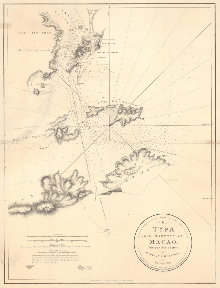
The Typa and Harbour of Macao; Principally from a Survey by Captain P. Heywood, of The Royal Navy.
sold
- Digital Map Information
- Suitable for large format printing
- File Size: 20.15 MB
- File Type: ZIP / TIFF
- ICC color profile embedded
- Delivered instantly via download link
This is the only known example of the 1809 Laurie and Whittle first edition of Peter Heywood's seminal survey of Macau (Macao) and nearby Taipa. This survey, conducted independently while Heywood's ship, the La Dedaigneuse, was being refitted in Macau, is the most important mapping of Macau since the 1778-79 survey of Heywood's erstwhile hydrography instructor, captain, and lifelong nemesis, Captain William Bligh of Bounty infamy. The survey appeared in the context of the Napoleonic Wars, when Franco-Spanish fleets were plaguing East India Company (EIC) fleets, and the British were keen to establish a foothold in the Pearl River Delta. Taipa, being a long-established EIC mooring point, was the prime target. (more details)
One of the most distinctive maps of the Dutch Golden Age.

Nova Belgica Et Anglia Nova.
sold
- Digital Map Information
- Suitable for large format printing
- Full resolution TIFF file
- ICC color profile embedded
- Delivered instantly via download link
This is a gorgeous 1643 edition of Willem Blaeu's foundational 1634 map of the American Northeast, presenting the regions settled by the Dutch (New Netherlands) and the English (New England). Uniquely oriented to the west, Blaeu's map covers the American coast from Virginia, past New York and Long Island to Cape Cod, New England, and Quebec. The map is the first of the region to depict the fur-bearing and food animals of the region accurately, and it does so in profusion. Between this imagery and the fleet of trade ships heading towards the coast, the decorative elements vividly emphasize the region's resource wealth. (more details)
One of the most important printed images of George Washington ever issued.

The Washington Family. George Washington his Lady, and her two Grandchildren by the name of Curstis. / La Famille de Washington. George Washington, Son Espose, et ses duex petits Enfants du Nom de Custis.
sold
- Digital Map Information
- Suitable for large format printing
- DPI: 600
- File Size: 68.69 MB
- File Type: ZIP / TIFF
- ICC color profile embedded
- Delivered instantly via download link
A rare 1798 Edward Savage view of George Washington and his family at Mount Vernon - one of the few engraved images of Washington issued during his lifetime. The work illustrates Washington in all his roles: a military leader, a family man, and a visionary politician. It is considered one of the most important printed images of George Washington ever issued. (more details)
First English reconnaissance of Spanish settlement in California.
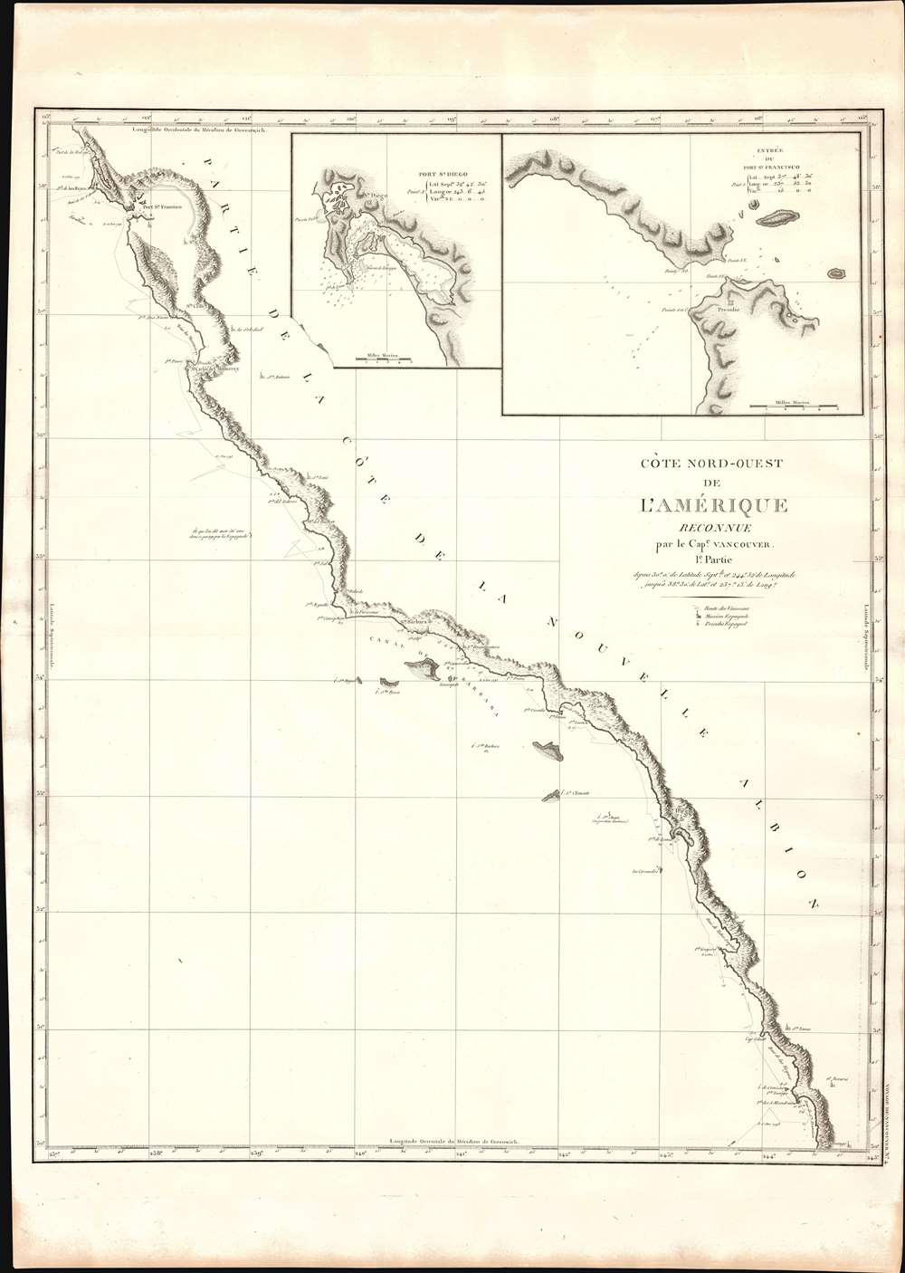
Cote Nord-Ouest de L'Amerique Reconnue par le Cape. Vancouver. 1e Partie.
$1,500.00
Acquire
- Digital Map Information
- Suitable for large format printing
- DPI: 600
- File Size: 24.66 MB
- File Type: ZIP / TIFF
- ICC color profile embedded
- Delivered instantly via download link
One of the great navigator George Vancouver's most important and influential maps, this is his 1799 charting of the California coastline roughly from Santo Domingo, Mexico, to San Francisco Bay. Vancouver's exploration of the California coastline was significant, breaking the Spanish wall of silence and producing the first English reconnaissance on Spanish settlement and colonization of the West Coast. Vancouver's mapping of California generated the finest coastal chart of the region to date. (more details)
Boulder Dam: 'Forecasting the world's greatest Land Boom!'

Kingman The Golden Gateway to Proposed Boulder Dam.
sold
- Digital Map Information
- Suitable for large format printing
- File Size: 79.43 MB
- File Type: ZIP / TIFF
- ICC color profile embedded
- Delivered instantly via download link
This is the only known example of a 1928 double-sided broadside promoting Kingman, Arizona, in anticipation of the construction of the Boulder Dam. The map promotes the 'Golden Gate Addition,' which developers 'Bolder Dam Properties' predict will be the 'world's greatest land boom.' (more details)
In the wake of the Revolutionary War.
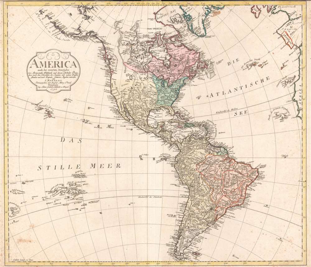
America nach der zweyten Ausgabe von Arrowsmiths Weltcharte und dessen Globular Projection nach den Berichten der Jesuiten und anderer Reisebe Schreiber, und nach Raymals, Gatterers, Angaben entworten von C. Mannert.
sold
- Digital Map Information
- Suitable for large format printing
- Full resolution TIFF file
- ICC color profile embedded
- Delivered instantly via download link
A scarce 1796 map of North and South America by Conrad Mannert. The map depicts the Americas shortly following the close of the American Revolutionary War (1775 - 1783). (more details)
Targeting the Home Islands.

Japan, The Target A Pictorial Jap-Map.
sold
- Digital Map Information
- Suitable for large format printing
- File Size: 18.23 MB
- File Type: ZIP / TIFF
- ICC color profile embedded
- Delivered instantly via download link
This is a rare 1944 Ernest Dudley Chase pictorial map of Japan, Korea, and Taiwan, reflecting the steady advance of Allied forces towards the Home Islands in the final phase of World War II (1939 - 1945) in the Pacific. It is signed by Chase in pencil on the lower margin. (more details)
Greeting the Atomic Age! The end of war and free energy!
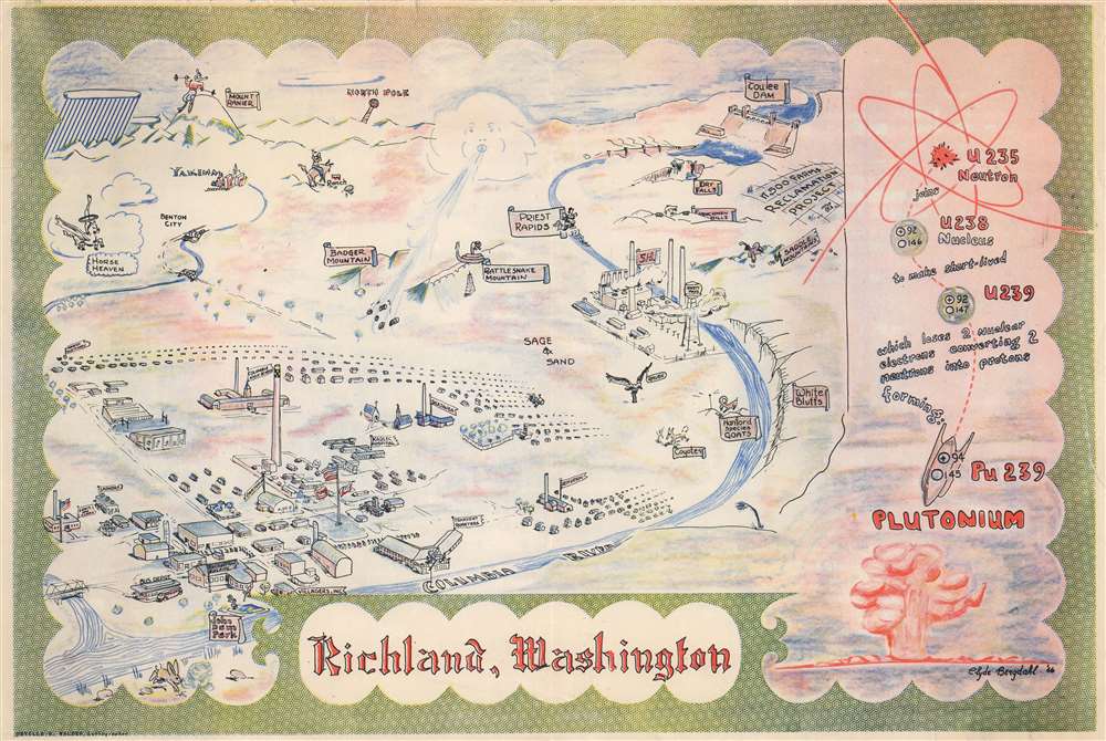
Richland, Washington.
sold
- Digital Map Information
- Suitable for large format printing
- File Size: 15.37 MB
- File Type: ZIP / TIFF
- ICC color profile embedded
- Delivered instantly via download link
This 1946 Clyde Bergdahl pictorial map of Richland, Washington, illustrates the 'Atomic City' between World War II (1939 - 1945) and the beginning of the Cold War (1947 - 1991). The imagery here is significant in illustrating the remarkable and ephemeral enthusiasm with which Americans greeted the Atomic Age - which seemed to promise endless free energy and the end to war. (more details)
'Out of the World and onto the Planet! Out of the cities and on to Planetedges.'

[The Pacific Basin].
sold
A rare distinctive persuasive map of the Pacific Basin produced in 1969 by the Diggers, a group of artists and political activists in San Francisco that intersected with other currents of 1960s Bay Area counterculture. (more details)
This map will 'add ten or more years to your life.'

North Lake Worth Palm Beach County, Florida. An Opportunity to Own a Home on the Most Beautiful Lake in Florida.
sold
- Digital Map Information
- Suitable for large format printing
- File Size: 21.53 MB
- File Type: ZIP / TIFF
- ICC color profile embedded
- Delivered instantly via download link
This is a rare 1913 Bryant and Greenwood map and promotional brochure advertising the initial development of North Lake Worth. This is the first map we've seen promoting Florida real estate directly to the elderly, claiming it will add 'ten or more years to your life.' (more details)
'The cartographic model for the next thirty years' -Kershaw
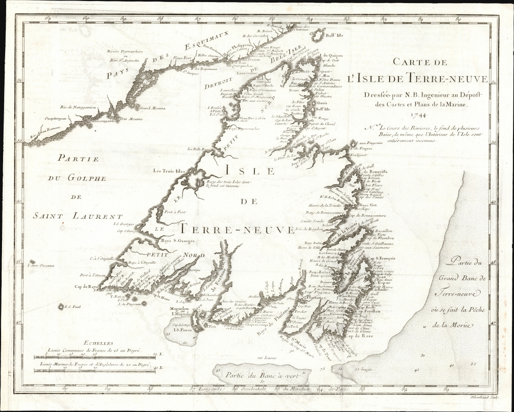
Carte De L'Isle de Terre-Neuve Dressée-par N. B. Ingenieur au Dépost des Cartes et Plans de la Marine 1744.
$750.00
Acquire
- Digital Map Information
- Suitable for large format printing
- File Size: 7.81 MB
- File Type: ZIP / TIFF
- ICC color profile embedded
- Delivered instantly via download link
This is the 1744 Bellin map of Newfoundland, a keystone map that set the standard for the mapping of the island for the third quarter of the 18th century. Newfoundland commanded a strategic position at the mouth of the St. Lawrence River, but its importance as a fishery would resonate throughout the century. The map's scope encompasses not only the island but also its position relative to the Labrador coast and the codfish-rich Grand Banks, emphasizing those important points. (more details)