
Employs a different color for each of the city's cadastrals.
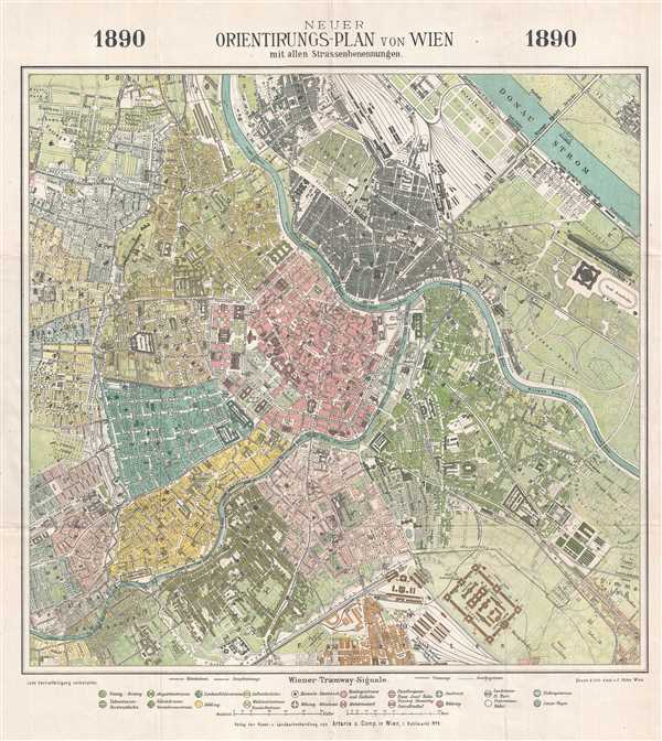
Neuer Orientirungs-Plan von Wien mit allen Strassenbenennungen.
sold
- Digital Map Information
- Suitable for large format printing
- File Size: 11.08 MB
- File Type: ZIP / TIFF
- ICC color profile embedded
- Delivered instantly via download link
This is an 1890 F. Köke city map or plan of Vienna, Austria. The map depicts the city from Währing and Neulerchenfeld to Leopoldstadt and Simmering and from Brigittenau to Favoriten. Each of the different cadastrals are numbered, labeled, and colored differently ... (more details)
Two different locations on Long Island are sketched here - Sands Point and Long Beach Bay.
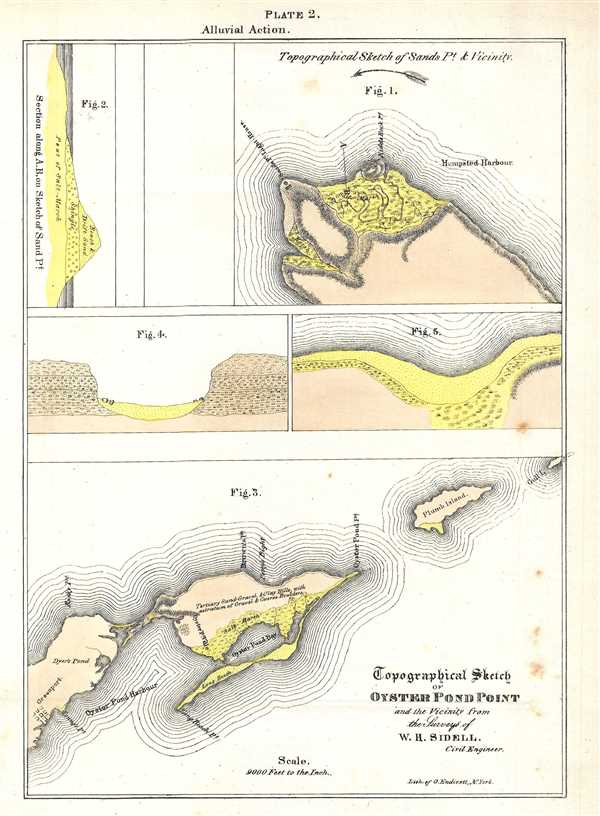
Topographical Sketch of Oyster Pond Point and the Vicinity from the Surveys of W. H. Sidell.
sold
- Digital Map Information
- Suitable for large format printing
- DPI: 300
- File Size: 1.37 MB
- File Type: ZIP / TIFF
- ICC color profile embedded
- Delivered instantly via download link
This is an 1842 William Mather lithograph plate from his Geology of New York, Part I depicting Oyster Pond Point and Sands Point, Long Island. Today, the areas in Figure 3 labeled here as Oyster Pond Harbour and Oyster Pond Bay are known as the Peconic River and ... (more details)
Compares the relative size of the world's lakes and islands.

Comparative Size of Lakes and Islands.
sold
- Digital Map Information
- Suitable for large format printing
- File Size: 6.66 MB
- File Type: ZIP / TIFF
- ICC color profile embedded
- Delivered instantly via download link
This is an 1857 J. H. Colton curious topical chart of the world's great islands and lakes. The chart is divided into lakes and islands of the Eastern and Western Hemispheres. Curiously, the chart does not include Greenland - whose northern limits had not yet ... (more details)
A cave in upstate New York which was explored by two ordinary people in the early 1830s.

Ball's Cave, Schoharie Court House.
sold
- Digital Map Information
- Suitable for large format printing
- DPI: 300
- File Size: 2.69 MB
- File Type: ZIP / TIFF
- ICC color profile embedded
- Delivered instantly via download link
This is an 1842 William Mather lithograph plate from his Geology of New York, Part I depicting Ball's Cave. Ball's Cave was located in Schoharie County about two miles from the courthouse in Schoharie. It was discovered and explored by John Gebhard and John ... (more details)
One of a kind map of a Civil War Camp in Arlington Heights, Virginia.

Encampment of the 25th Regiment Maine Volunteers.
sold
- Digital Map Information
- Suitable for large format printing
- File Size: 3.93 MB
- File Type: ZIP / TIFF
- ICC color profile embedded
- Delivered instantly via download link
This is an unusual Civil War broadside map illustrating the Encampment of the 25th Regiment Maine Volunteers. The map illustrates the Arlington Heights Camp of the 25th Maine Regiment where they spent the Winters of 1862 and 1863. The 25th Maine Regiment ... (more details)
Japanese propaganda map illustrating WWI and the Russo-Japanese War. The fulfillment of the Meiji Dream!
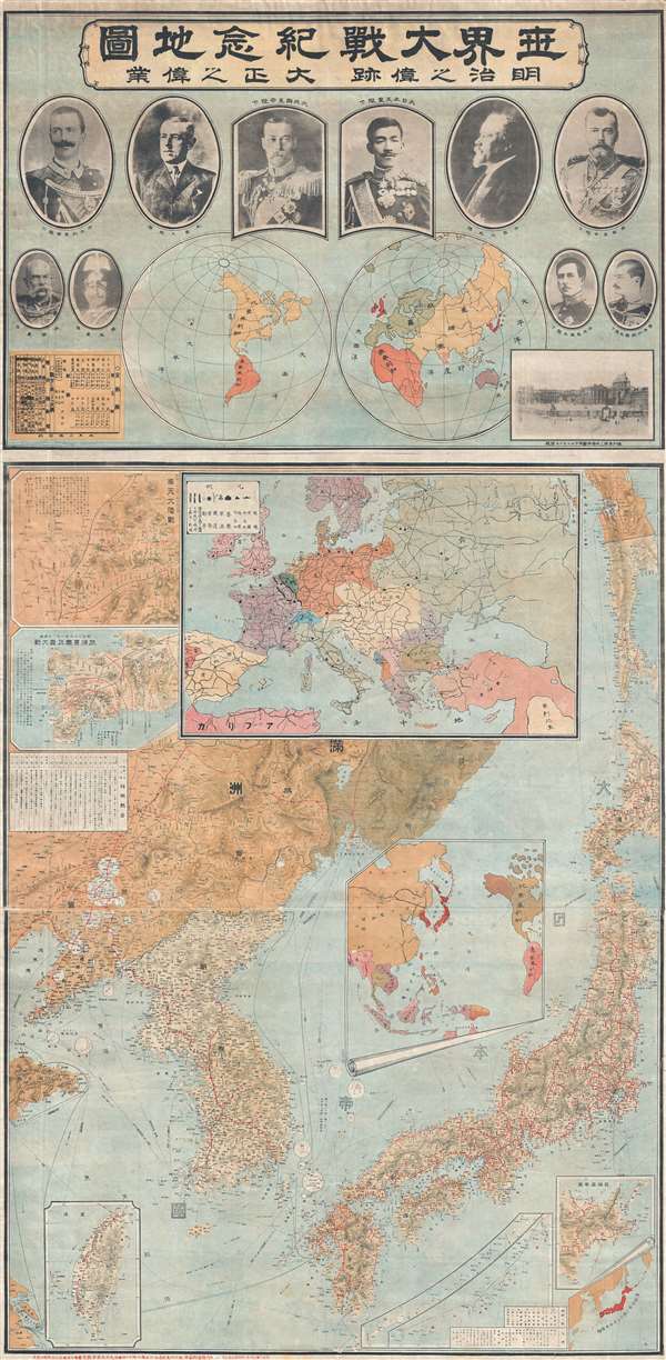
世界大戰紀念地圖 明治之偉跡 大正之偉業 / Commemorative Map of the World War. The Great Footprint of Meiji, the Great Undertaking of Taisho.
sold
- Digital Map Information
- Suitable for large format printing
- File Size: 65.91 MB
- File Type: ZIP / TIFF
- ICC color profile embedded
- Delivered instantly via download link
A rare, exceptional, and impressively proportioned 1919 Taishō 8 Japanese propaganda map prepared to celebrate Japanese achievements in World War I (Jul 28, 1914 - Nov 11, 1918) and the Russo-Japanese War (Feb 8, 1904 - Sep 5, 1905). During the course ... (more details)
Super rare Tobacco Advertising map of Florida!
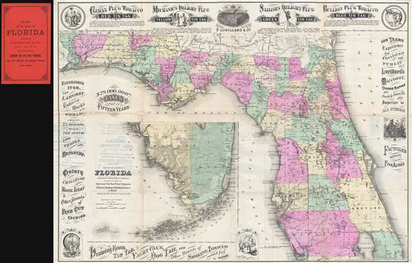
Colton's Map of the State of Florida Presented by P. Lorillard and Co. Jersey City N.J. Manufacturers of Genuine Tin Tag Plug Tobacco Fine Cut Chewing and Smoking Tobacco and Snuff.
sold
- Digital Map Information
- Suitable for large format printing
- File Size: 14.97 MB
- File Type: ZIP / TIFF
- ICC color profile embedded
- Delivered instantly via download link
This is a rare 1882 promotional advertising map of Florida issued by 'G. W. and C. B. Colton' and Pierre Lorillard. The map was issued to promote the Lorillard Tobacco Company of New Jersey, at the time one of the largest and most profitable tobacco ... (more details)
Includes several pieces of Beatles ephemera, including one of the earliest Beatles maps of Liverpool ever created.

Beatles Map. / The Beatles Collection From Liverpool to the World.
sold
This is an extremely rare and complete 1974 City of Liverpool Beatles souvenir set including a Beatles pictorial map of Liverpool, a Beatles Fan Club letter, several Beatles postcards, and other Beatles ephemera. Per the National Museums of Liverpool, ... (more details)
A rare original example of Rummel's panoramic bird's-eye view of Yale Univeristy.

[Yale University.]
sold
- Digital Map Information
- Suitable for large format printing
- File Size: 10.25 MB
- File Type: ZIP / TIFF
- ICC color profile embedded
- Delivered instantly via download link
A scarce 1906 signed photogravure bird's-eye view of Yale University drawn by Richard Rummell and published by F. D. Nichols of Boston. The view is centered on Osborne Hall (now demolished and replaced with Bingham Hall) with its distinctive ... (more details)
Impressive large format nautical chart of the West Indies.

Chart of the Gulf of Mexico and Windward Passages including the Islands of Cuba, Haiti, Jamaica Puerto Rico and the Bahamas.
sold
- Digital Map Information
- Suitable for large format printing
- File Size: 91.19 MB
- File Type: ZIP / TIFF
- ICC color profile embedded
- Delivered instantly via download link
A large and expansive 1871 James Imray blueback nautical chart or maritime map of the Gulf of Mexico and the West Indies, including the Greater Antilles. As a working chart, it bears all of the hallmarks of a shipboard chart and a life at sea, including pencil marks related to navigation. The map covers from Mexico to the Virgin Island and from northern Florida to Honduras, including all of the Gulf of Mexico, Cuba, Florida, the Yucatan, Santo Domingo (Hispaniola), Jamaica, Porto Rico, and the Bahamas, as well as the Gulf Coast in the vicinity of Texas, Mississippi, Louisiana, and Alabama. Inset maps detail the River Goazacolcos, the port of Veracruz (Mexico), and the Laguna de Terminos. (more details)
Beautiful, rare, and important, this blueback chart of Jamaica was issued in the year of the Great Jamaican Slave Revolt or Baptist War.
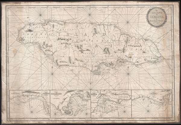
The Island of Jamaica, by W. Heather.
sold
- Digital Map Information
- Suitable for large format printing
- Full resolution TIFF file
- ICC color profile embedded
- Delivered instantly via download link
This is a rare and stunning 1832 blueback nautical chart or map of Jamaica by William Heather and John W. Norie. As a working chart, it bears all of the hallmarks of a shipboard chart and a life at sea. The map details all of Jamaica with four inset detail harbor maps along the bottom, from left: Savanna, Portland Point, Kingston, Morant. Sounding along the south coast, and in the insets, in fathoms.
Unlike many British blueback charts, the present map actually offers considerable inland detail. Here Jamaica is divided into three counties (Cornwall, Middlesex and Surry), each of which is in turn subdivided into Parishes. The chart includes significant topographical detail, including roads, rivers, mountains, towns, churches, military camps, and more. (more details)
Unlike many British blueback charts, the present map actually offers considerable inland detail. Here Jamaica is divided into three counties (Cornwall, Middlesex and Surry), each of which is in turn subdivided into Parishes. The chart includes significant topographical detail, including roads, rivers, mountains, towns, churches, military camps, and more. (more details)
Unusually oriented and enormous nautical chart detailing a voyage through the Bahamas to the Dry Tortugas.
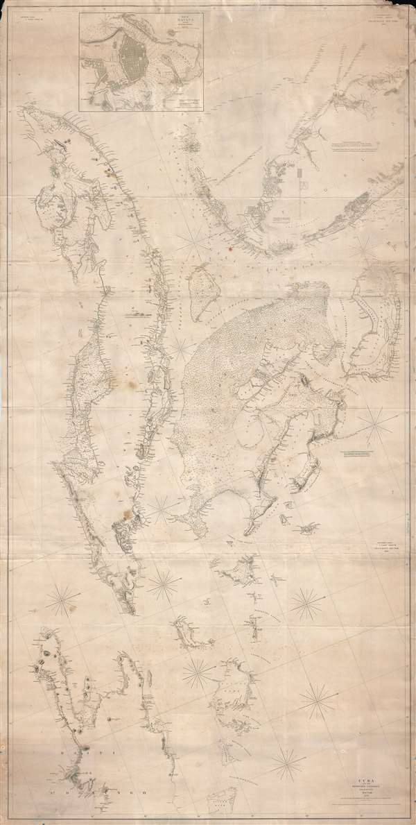
Southern Coast, U. States. Sheet VIII. / Cuba and the Windward Passages. / Southern Coast.. U. States. Sheet VII.
sold
- Digital Map Information
- Suitable for large format printing
- DPI: 300
- File Size: 72.09 MB
- File Type: ZIP / TIFF
- ICC color profile embedded
- Delivered instantly via download link
An enormous and expansive 1844 - 1857 nautical chart or maritime map of Southern Florida, the Bahamas, and Cuba. Curiously oriented to the northeast, this sprawling map covers from central Florida in the vicinity of Tampa Bay, to western ... (more details)
Famed Savannah artist Christopher Murphy's only pictorial map.

Daughters of the American Revolution Historic Map of Georgia.
sold
- Digital Map Information
- Suitable for large format printing
- DPI: 300
- File Size: 15.12 MB
- File Type: ZIP / TIFF
- ICC color profile embedded
- Delivered instantly via download link
This is a rare 1938 golden age pictorial map of Georgia published by the Daughters of the American Revolution and drawn by Savannah's favorite hometown artist Christopher Murphy. The map focuses on historical events, sights, ... (more details)
An incredibly detailed city plan of Singapore.
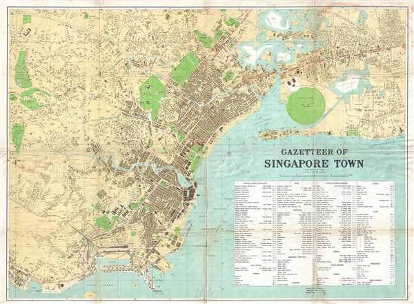
Gazetteer of Singapore Town.
sold
- Digital Map Information
- Suitable for large format printing
- File Size: 26.67 MB
- File Type: ZIP / TIFF
- ICC color profile embedded
- Delivered instantly via download link
This is a 1938 F.M.S. Survey city map or plan of Singapore. The map depicts the city of Singapore from Bukit Timah Road and Telok Blanga Road to the Sea View Hotel and Paya Lebar. Highly detailed, individual buildings are ... (more details)
Chart of the Canary Islands from Vidal's survyes.
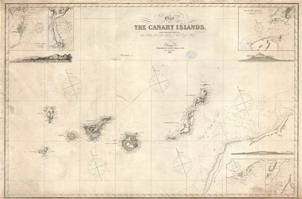
Chart of the Canary Islands, Drawn from the Surveys of Capt. Vidal and Liet. Arlett of the Royal Navy.
sold
- Digital Map Information
- Suitable for large format printing
- File Size: 22.22 MB
- File Type: ZIP / TIFF
- ICC color profile embedded
- Delivered instantly via download link
An elegant 1875 James Imray nautical chart or map of the Canary Islands. This map was originally published by Imray in 1860, the present example being a later edition, based upon the important surveys of Captain Alexander Thomas Emeric Vidal of the Royal Navy. Centered on Gran Canaria, the map extends to cover all of the islands as well as parts of the adjacent west African coast. Insets details Santa Cruz (Tenerife), Puerto da la Luz (Las Palmas, Gran Canaria), Arreciffe (Arrecife, Lanzarote), the Strait of Rio, and Bocayna Strait. Profiles detail Tenerife, Grand Canaria, and Santa Cruz. (more details)
Scarce nautical chart illustrating the Guianas.

Coast of Guiana.
sold
- Digital Map Information
- Suitable for large format printing
- File Size: 53.4 MB
- File Type: ZIP / TIFF
- ICC color profile embedded
- Delivered instantly via download link
This is a large and impressive nautical chart of maritime map of the British Guiana, Surinam, and French Guiana coast in South America. The map covers from Trinidad and Tobago, and the mouth of the mouth of the Orinoco in Venezuela, east as far as Cape Orange and the River Uassa (River Oyapok), including the modern-day nations of British Guiana, Surinam (Dutch Guiana), and French Guiana. Insets detail the River Surinam, The Demerara and Essequibo Rivers, the River Maroni, Cayenne, the River Corentyn, and the Salut Islands. The chart contains copious annotations describing the difficult river navigation in this region. (more details)
Illustrates the island's Arctic ruggedness and the fearsome Kodiak bear!
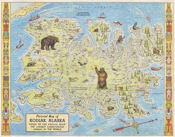
Pictorial Map of Kodiak, Alaska 'Home of the Kodiak Bear' the Largest Carnivorous Animal in the World.
sold
- Digital Map Information
- Suitable for large format printing
- File Size: 13.04 MB
- File Type: ZIP / TIFF
- ICC color profile embedded
- Delivered instantly via download link
This is a 1948 Lowell E. Jones pictorial map of Kodiak, Alaska. Oriented from the east, the map depicts the whole of Kodiak Island from Shelikof Strait to Sitkaudak Island and from Olga Bay to Afgonak Island. Standing ... (more details)
Map of the Holy Land noting the lands claimed by the Tribes of Israel.

Terrae Sanctae Tabula e Scripturae Sacrae, Flavii Josephi, Eusebii et Divi Heironymi …
sold
- Digital Map Information
- Suitable for large format printing
- DPI: 300
- File Size: 14.67 MB
- File Type: ZIP / TIFF
- ICC color profile embedded
- Delivered instantly via download link
A beautiful example of Guillaume and Joseph Delisle's 1763 decorative map of the Holy Land, including Israel and Palestine. In two sheets, the map depicts the region from Gaza and the Dead Sea north to Sidon (modern ... (more details)
Lists hundreds of Irish family names from all over the Emerald Isle.
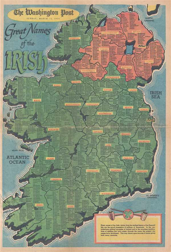
Great Names of the Irish.
sold
- Digital Map Information
- Suitable for large format printing
- File Size: 14.25 MB
- File Type: ZIP / TIFF
- ICC color profile embedded
- Delivered instantly via download link
This is a 1953 Washington Post map of Ireland featuring Irish family names. The map depicts the entirety of the Emerald Isle from the North Channel to the Celtic Sea and from the Atlantic Ocean to the Irish Sea. ... (more details)
Spectacular dissected wall map of the Untied State revealing a remarkable and ephemeral deportment of the Plains States.
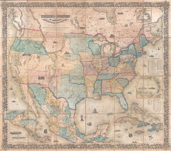
Colton's map of the United States of America, the British provinces, Mexico and the West Indies. Showing the country from the Atlantic to the Pacific Ocean.
sold
- Digital Map Information
- Suitable for large format printing
- DPI: 300
- File Size: 126.09 MB
- File Type: ZIP / TIFF
- ICC color profile embedded
- Delivered instantly via download link
This is a large 1853/54 J. H. Colton dissected wall map of the United States with significant Trans-Mississippi and Great Plains content. This is the largest and most significant of the three separate issue ... (more details)