
Nice first edition map of Egypt by David Burr.

Egypt.
sold
- Digital Map Information
- Suitable for large format printing
- DPI: 300
- File Size: 4.85 MB
- File Type: ZIP / TIFF
- ICC color profile embedded
- Delivered instantly via download link
This is a lovely 1834 first edition map of Egypt by David H. Burr. It depicts Egypt, centered on the Nile River from its delta on the Mediterranean, south as far as Asalieh. Burr notes numerous cities and villages along the river as well as beautifully rendered ... (more details)
Striking map of Greece.

Greece.
sold
- Digital Map Information
- Suitable for large format printing
- DPI: 300
- File Size: 5.33 MB
- File Type: ZIP / TIFF
- ICC color profile embedded
- Delivered instantly via download link
This is David H. Burr’s 1835 first edition map of Greece. It covers from the Sea of Marmora south to include Candia or Crete. Towns, rivers, mountains, islands and various other important topographical details are noted. Elevation throughout is rendered by ... (more details)
Beautiful map representing Prussia during the early 19th century.

Prussian States.
sold
- Digital Map Information
- Suitable for large format printing
- DPI: 300
- File Size: 4.62 MB
- File Type: ZIP / TIFF
- ICC color profile embedded
- Delivered instantly via download link
This is a beautiful 1835 first edition map of Prussia by David H. Burr. Covering parts of the modern day nations of Germany, Poland and Lithuania, Prussia stretches across the map from the Lower Rhine moving eastward, including Brandenburg and Silesia, to ... (more details)
Map detailing Galveston Bay in Texas.

(I No. 2) Preliminary Sketch of Galveston Bay.
sold
- Digital Map Information
- Suitable for large format printing
- DPI: 300
- File Size: 6.93 MB
- File Type: ZIP / TIFF
- ICC color profile embedded
- Delivered instantly via download link
An uncommon 1851 U.S. Coast Survey nautical chart or maritime map of Galveston Bay, Texas. The map covers from Turtle Bay to the entrance to Galveston Bay, including the City of Galveston, Galveston Island, and Bolivar Peninsula. Supplementary inset maps ... (more details)
Nautical Chart depicting Alabama's Mobile Bay.
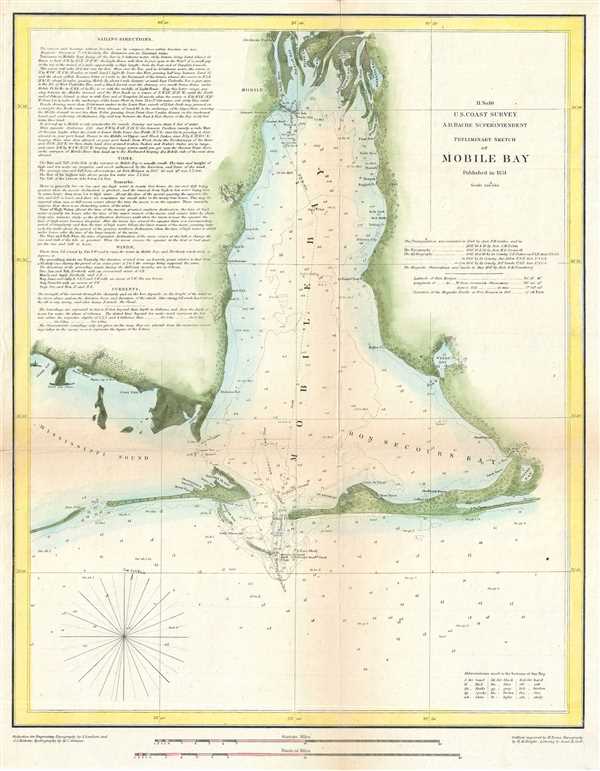
H No. 10 Preliminary Sketch of Mobile Bay.
sold
- Digital Map Information
- Suitable for large format printing
- DPI: 300
- File Size: 5.1 MB
- File Type: ZIP / TIFF
- ICC color profile embedded
- Delivered instantly via download link
This is an uncommon 1851 U.S. Coast Survey Chart or Map of Mobile Bay, Alabama. It covers from Grand Bay and the mouths of the Alabama and Apalachee Rivers south to Mobile Point, Dauphine Island, and the Sand Island Bank. Also extends westward into the ... (more details)
Map depicting the Coast Survey's early mappings of the Puget Sound.

Sketch K Showing the Progress of the Survey in Section No. XI (Upper Sheet) From Tillamook Bay to the Boundary from 1851 to 1860.
sold
- Digital Map Information
- Suitable for large format printing
- File Size: 7.63 MB
- File Type: ZIP / TIFF
- ICC color profile embedded
- Delivered instantly via download link
An uncommon hand-colored 1860 U.S. Coast Survey map and triangulation chart of Washington, Vancouver and the Puget Sound from Tillamook Head to Vancouver Island, including Juan De Fuca Strait, the Puget Sound, Olympia, and Seattle. Details from the ... (more details)
Unusual nautical chart of Drakes Bay, California - Sir Francis Drake's most likely landing spot.

Preliminary Chart of Drake's Bay California.
sold
- Digital Map Information
- Suitable for large format printing
- File Size: 8.86 MB
- File Type: ZIP / TIFF
- ICC color profile embedded
- Delivered instantly via download link
An uncommon 1860 map of Drakes Bay or Puerto De Los Reyes on the Point Reyes national seashore in California. Located approximately 30 miles northwest of San Francisco, Drakes Bay has long been considered the most likely landing site of the ... (more details)
Nautical chart detailing the Delta of the Mississippi and its surrounding coast.

Sketch H Showing the Progress of the Survey in Section No. VIII from 1846 - 1860.
sold
- Digital Map Information
- Suitable for large format printing
- File Size: 9.03 MB
- File Type: ZIP / TIFF
- ICC color profile embedded
- Delivered instantly via download link
A very attractive example of the 1860 U.S. Coast Survey nautical chart or map of the Mississippi River Delta and environs. Centered on the fanlike river delta itself, this map extends westward as far as Marsh Island and Vermillion Bay and ... (more details)
Map of Victorian London popular with Jack the Ripper researchers showing parks, streets, and important buildings.
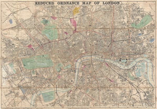
Whitbread's Reduced Ordnance Map of London.
sold
- Digital Map Information
- Suitable for large format printing
- File Size: 33.51 MB
- File Type: ZIP / TIFF
- ICC color profile embedded
- Delivered instantly via download link
A very attractive large map of London, England, published by Whitbread in 1873. As this title suggests, this map was reduced from the Ordnance Survey for the consumer market. The map covers from the West End around Edgeware Road to ... (more details)
Large decorative nautical chart of the Outer Banks.
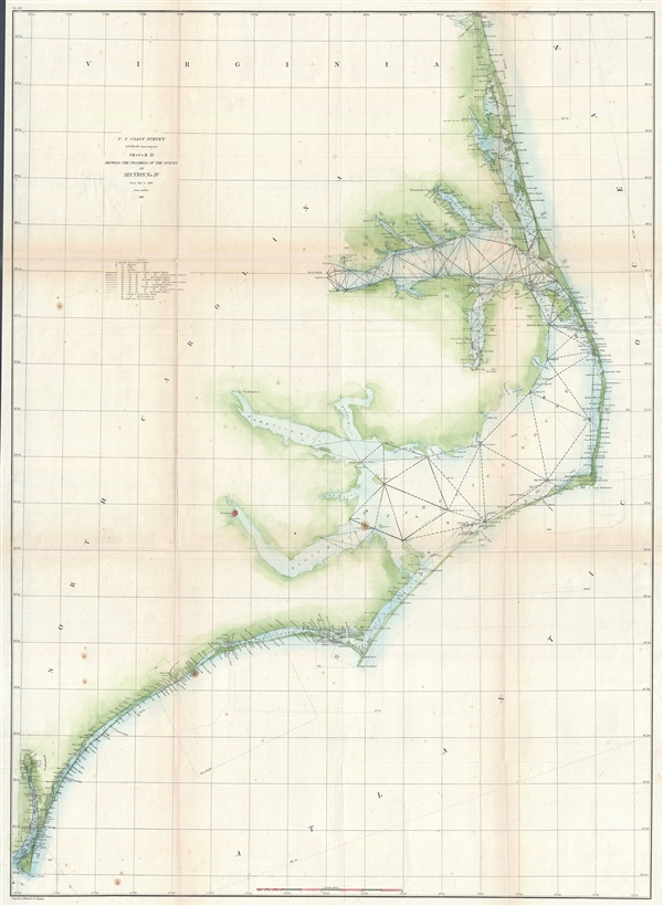
Sketch D Showing the Progress of the Survey in Section No. IV from 1845 to 1860.
sold
- Digital Map Information
- Suitable for large format printing
- File Size: 16.18 MB
- File Type: ZIP / TIFF
- ICC color profile embedded
- Delivered instantly via download link
This is an exceptional example of the 1860 U.S. Coast Survey's progress chart for the coasts of Virginia and North Carolina. Covers from Cape Henry, Virginia, south past the Pamlico Sound and Cape Hatteras, to Cape Fear. It was ... (more details)
World War II Era Nautical map of Oahu.

Hawaiian Islands Oahu.
sold
- Digital Map Information
- Suitable for large format printing
- File Size: 29.06 MB
- File Type: ZIP / TIFF
- ICC color profile embedded
- Delivered instantly via download link
This is an uncommon 1945 nautical chart or maritime map of Oahu - the most populous island in the Hawaiian Archipelago. Offers some inland detail as well including topography, rivers, roads, railroad lines, craters, peaks and ... (more details)
Rare separately issued map of Bar Harbor by the United States Coast Survey.

Bar Harbor Mount Desert Island Maine.
sold
- Digital Map Information
- Suitable for large format printing
- File Size: 7.77 MB
- File Type: ZIP / TIFF
- ICC color profile embedded
- Delivered instantly via download link
A scarce 1885 U.S Coast and Geodetic Survey nautical chart or maritime map of Bar Harbor, Mount Desert Island, Maine. Presented on a polyconic projection, this map is centered on the town of Bar Harbor, but covers much of ... (more details)
A foundational map of Persia, Arabia, and India.

Premiere Partie de la Carte d'Asie contenant La Turquie, L'Arabie, La Perse, L'Inde en deca du Gange et de la Tartarie ce qui est limitrophe de la Perse et de l'Inde.
sold
- Digital Map Information
- Suitable for large format printing
- DPI: 300
- File Size: 34.98 MB
- File Type: ZIP / TIFF
- ICC color profile embedded
- Delivered instantly via download link
A monumental and highly detailed 1751 map of India, Persia, and Arabia by the French cartographer Jean Baptiste Bourguignon d'Anville. Centered on Persia, this map covers from Istanbul to eastern India and Tibet, and from ... (more details)
A large decorative map of Milwaukee.
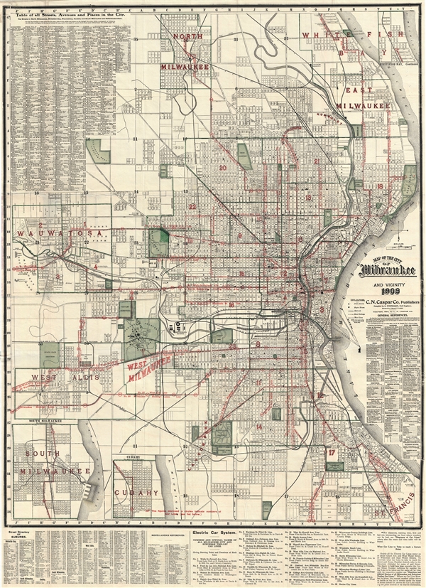
Map of the City of Milwaukee and Vicinity.
sold
- Digital Map Information
- Suitable for large format printing
- File Size: 41.4 MB
- File Type: ZIP / TIFF
- ICC color profile embedded
- Delivered instantly via download link
A dramatic and scarce 1909 large scale map of Milwaukee, Wisconsin by the C. N. Caspar Company. The map extends from Wauwatosa to Lake Michigan and from North Milwaukee to St. Francis. City wards, schools, engine houses, ... (more details)
Sanson’s 1650 map of North America and 1656 map of New Mexico seem to the present writer by far the most interesting and important maps … - C. Wheat
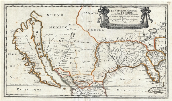
Le Nouveau Mexique, et la Floride: Tirées de diverses Cartes, et Relations. Par N. Sanson d'Abbeville Geogr ordre du Roy. A Paris. Chez Pierre Mariette, Rue S. Iacque a l'Esperance Avec Privilege du Roy, pour vingt Ans. 1656.
sold
- Digital Map Information
- Suitable for large format printing
- DPI: 300
- File Size: 11.08 MB
- File Type: ZIP / TIFF
- ICC color profile embedded
- Delivered instantly via download link
Sanson and Mariette's 1656 first edition map of the central and western part of North America is one of the most important maps ever published pertaining to the American west. This map represents the first time this ... (more details)
Exceptional large folding map of Central Park.

Map of the Central Park January 1st 1870.
sold
- Digital Map Information
- Suitable for large format printing
- File Size: 9.73 MB
- File Type: ZIP / TIFF
- ICC color profile embedded
- Delivered instantly via download link
An altogether extraordinary hand colored map of New York City's Central Park prepared and printed by Knapp for inclusion in the Thirteenth Annual Report of the Board of Commissioners of the Central Park. This is an ... (more details)
Extraordinary bird's eye view of India during the 1857 Indian Rebellion.
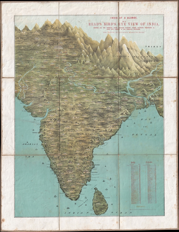
India at a Glance. No. 2. Read's Birds' Eye View of India, showing all the principal cities, Military Stations, Rivers, Railways, Telegraphs, &C. From Cape Comorin to the Himalaya Mountains.
sold
- Digital Map Information
- Suitable for large format printing
- File Size: 24.21 MB
- File Type: ZIP / TIFF
- ICC color profile embedded
- Delivered instantly via download link
A map of the utmost rarity, this is Mary Read's 1857 chromolithograph bird's eye view of India. The view presents the subcontinent as it might be seen from somewhere high above the Indian ocean just south of Sri ... (more details)
The earliest map to use the term Great Lakes. Includes four fictional islands in Lake Superior later used to draw the post-Revolutionary War US-Canada border.
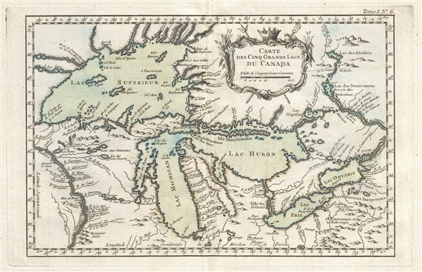
Carte des Cinq Grands Lacs du Canada.
sold
- Digital Map Information
- Suitable for large format printing
- Full resolution TIFF file
- ICC color profile embedded
- Delivered instantly via download link
An unusual 1764 variant edition Jacques-Nicholas Bellin influential map of the Great Lakes. This is the earliest known map to use the term 'Great Lakes'. Cartographically, this map follows Bellin's 1744 mapping ... (more details)
One of the earliest obtainable specific maps of Charleston, South Carolina.
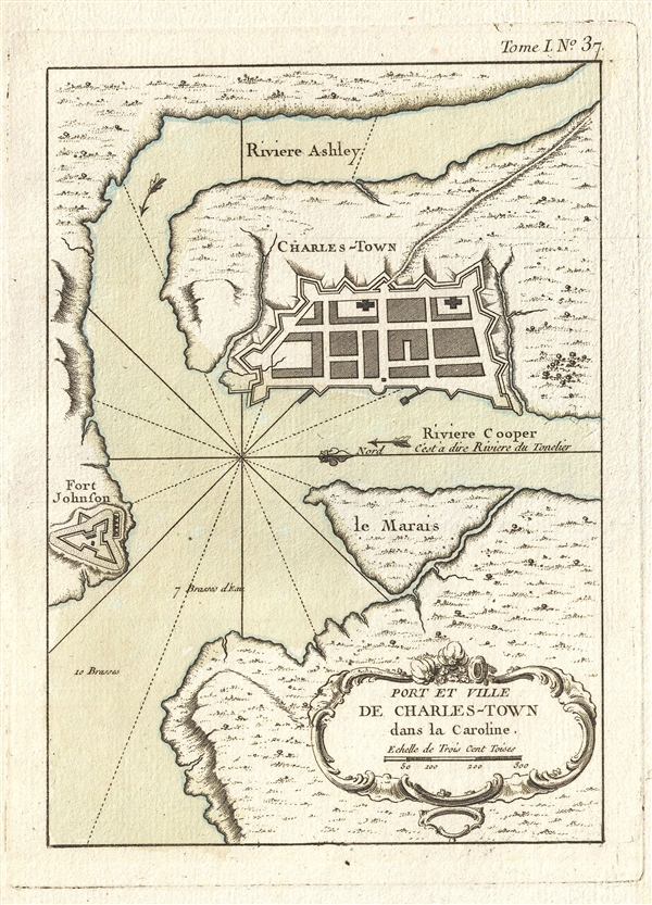
Port et Ville de Charles-Town dans la Caroline.
sold
- Digital Map Information
- Suitable for large format printing
- DPI: 300
- File Size: 2.31 MB
- File Type: ZIP / TIFF
- ICC color profile embedded
- Delivered instantly via download link
One of the earliest obtainable maps of Charleston, this is Jacques Nicholas Bellin's 1764 Port et Ville de Charles-Town dans la Caroline. Oriented to the west, this fine early map details the convergence of the ... (more details)
One of the earliest obtainable maps or plans of New Orleans, Louisiana.
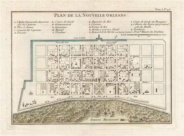
Plan de la Nouvelle Orleans.
sold
- Digital Map Information
- Suitable for large format printing
- DPI: 300
- File Size: 3.58 MB
- File Type: ZIP / TIFF
- ICC color profile embedded
- Delivered instantly via download link
This scarce 1764 map by J. N. Bellin is one of the earliest obtainable maps of New Orleans, Louisiana. Oriented to the northwest, Bellin's map covers the original settlement of New Orleans along the Mississippi ... (more details)