
One of George Vancouver's most beautiful and impressive maps.

Cote nord-ouest de l'Amerique. Reconnue par le Cape. Vancouver. Ve. Partie
sold
- Digital Map Information
- Suitable for large format printing
- DPI: 300
- File Size: 18.12 MB
- File Type: ZIP / TIFF
- ICC color profile embedded
- Delivered instantly via download link
One of the great navigator George Vancouver's beautiful maps, this 1799 chart focuses on the rugged coastline of the southern Alaska panhandle from modern day Yakutat Bay (Baie de Beering) to the Alexander Archipelago (Archipel du Roi George III). Traditionally, ... (more details)
The first published map of the northwest coast to show Vancouver Island, the Puget Sound, and the Columbia River.

Carte de la Partie de la Cote Nord-Ouest de L'Amerique Reconnue pendant Etes de 1792, 1793, et 1794
sold
- Digital Map Information
- Suitable for large format printing
- DPI: 300
- File Size: 17.19 MB
- File Type: ZIP / TIFF
- ICC color profile embedded
- Delivered instantly via download link
One of the great navigator George Vancouver's most important and influential maps, this is the 1799 general reconnaissance of the west coast of America from San Diego to Kodiak Island, Alaska. At last the west coast of America, particular the Pacific Northwest, ... (more details)
Rare early planning map of the Wollman Rink and Concert Grove part of Prospect Park, Brooklyn.

Design for the Arrangement of Pedestrian Concourse.
sold
- Digital Map Information
- Suitable for large format printing
- File Size: 2.72 MB
- File Type: ZIP / TIFF
- ICC color profile embedded
- Delivered instantly via download link
A rare 1871 example Vaux & Olmsted's map of part of Prospect Park, Brooklyn. His map focuses on the section of Prospect Park now occupied by Wollman Rink and the adjacent Concert Grove. Pathways, individual trees, pavilions, boat landings, seats, and fountains ... (more details)
A very early planning map of Prospect Park.

Design for Prospect Park as Proposed to be Laid Out for The City of Brooklyn.
sold
- Digital Map Information
- Suitable for large format printing
- File Size: 7.27 MB
- File Type: ZIP / TIFF
- ICC color profile embedded
- Delivered instantly via download link
A rare 1871 example of Vaux & Olmsted's map of Prospect Park, Brooklyn. Issued shortly after its 1867 completion, this is one of the first published maps to focus on the design of Prospect Park. Depicts the park as a whole and includes pathways, lakes, ... (more details)
A fine 18th century wall map of North America.

North America.
sold
- Digital Map Information
- Suitable for large format printing
- DPI: 300
- File Size: 40.79 MB
- File Type: ZIP / TIFF
- ICC color profile embedded
- Delivered instantly via download link
This is an exceptionally interesting and beautiful 1752 wall map of North America composed by Malachy Postlethwayte. Postlethwayte, an Englishman, prepared this map for issue in conjunction with the second edition (1752) of his popular Dictionary of ... (more details)
Vancouver's most important map. The first map to show Vancouver Island and the Puget Sound.

Cote Nord-Ouest de L'Amerique Reconnue par le Cape. Vancouver. 3e. Partie.
sold
- Digital Map Information
- Suitable for large format printing
- DPI: 300
- File Size: 21.35 MB
- File Type: ZIP / TIFF
- ICC color profile embedded
- Delivered instantly via download link
Considered to be the great navigator George Vancouver's most important and influential map, this is the third plate of his reconnaissance of the northwest coast of America. This 1799 map covers from Cape Lookout (modern day Oregon) northwards past ... (more details)
Striking Japanese Nautical of Singapore Strait.
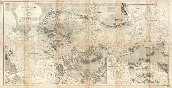
China Sea Singapore Strait.
sold
- Digital Map Information
- Suitable for large format printing
- File Size: 5.63 MB
- File Type: ZIP / TIFF
- ICC color profile embedded
- Delivered instantly via download link
This is a rare and striking large format 1923 Japanese nautical chart of Singapore Strait. Centered on Singapore Island, this maritime map covers from Great Karimum Island in the west quadrant to Pulo Bintang in the east, it extends north as far ... (more details)
Quite simply the largest, most beautiful, and most important early map of Hawaii ever published.
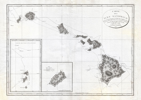
Carte des Iles Sandwich d'apres la reconnoissance qui en a ete faite dans les differentes relaches de la corvette La Decouverte et de sa conserve Le Chatham commandes par le Capt. Vancouver en 1792, 1793 et 1794.
sold
- Digital Map Information
- Suitable for large format printing
- DPI: 300
- File Size: 16.94 MB
- File Type: ZIP / TIFF
- ICC color profile embedded
- Delivered instantly via download link
A seminal map. This is a fine example of George Vancouver's 1799 map of the Hawaiian Islands, considered the largest, most important, and most beautiful map of Hawaii to appear in the 18th century. George Vancouver first sighted Hawaii on ... (more details)
Impressive wall map of India.

The East Indies, with the Roads.
sold
- Digital Map Information
- Suitable for large format printing
- DPI: 300
- File Size: 90.75 MB
- File Type: ZIP / TIFF
- ICC color profile embedded
- Delivered instantly via download link
This is a staggering wall size map of India and Ceylon originally issued in 1768 by Thomas Jeffreys. Covers the Indian subcontinent from Mekran in the west to Assam and Aracan in the east, and from Bhutan in the north, south to Ceylon and ... (more details)

Porto Rico and Virgin Isles. Haiti, Hispaniola or St. Domingo.
sold
- Digital Map Information
- Suitable for large format printing
- DPI: 300
- File Size: 19.46 MB
- File Type: ZIP / TIFF
- ICC color profile embedded
- Delivered instantly via download link
This fascinating hand colored 1814 map by Edinburgh cartographer John Thomson depicts the modern West Indies or Caribbean nations of Porto Rico, the Virgin Islands, Haiti, and the Dominican Republic. Divided into two sections, this is a ... (more details)
Identifies the tracks of the great 18th century navigators.
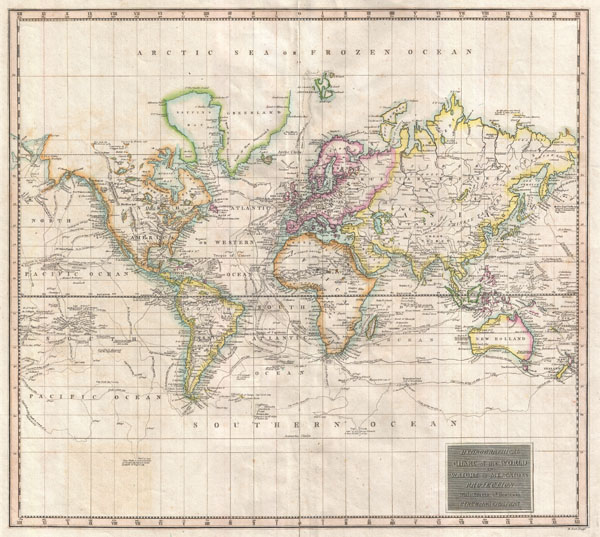
Hydrographical Chart of the World on Wright or Mercators Projection With Tracts of the Last Circumnavigators.
sold
- Digital Map Information
- Suitable for large format printing
- DPI: 300
- File Size: 14.13 MB
- File Type: ZIP / TIFF
- ICC color profile embedded
- Delivered instantly via download link
An excellent example of John Thomson's 1814 map of the world on Mercator's projection. Published in the 1814 edition of Thomson's General Atlas , this map was drawn to illustrate the great voyages of discovery of the late 18th ... (more details)
A rarely seen first state first edition of this important map.

West Indies.
sold
- Digital Map Information
- Suitable for large format printing
- DPI: 300
- File Size: 19.5 MB
- File Type: ZIP / TIFF
- ICC color profile embedded
- Delivered instantly via download link
This is a fascinating 1814 map of the West Indies and Central America by the Edinburgh cartographer John Thomson. It covers from the Carolinas south through Texas, Mexico and Central America to the northern part of South ... (more details)
The finest example of this map we have ever encountered.
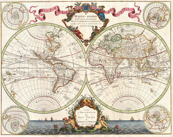
Mappe-Monde Dresse sur les Observations de Mrs. De L'Academie Royale des Sciences et quelque3s autres et sur les memoires les plus recens Par M. De L'Isle.
sold
- Digital Map Information
- Suitable for large format printing
- DPI: 300
- File Size: 19.55 MB
- File Type: ZIP / TIFF
- ICC color profile embedded
- Delivered instantly via download link
Published by the venerable Covens and Mortier firm, this is an exceptionally beautiful example of Guillaume de L'Isle's important c. 1730 map of the world in two hemispheres. The map consists of two central hemispheres, ... (more details)

cder Kinder Israel Auszug aus Egypten ... und Viertzig Jahrige Reyse.
sold
- Digital Map Information
- Suitable for large format printing
- DPI: 300
- File Size: 7.16 MB
- File Type: ZIP / TIFF
- ICC color profile embedded
- Delivered instantly via download link
An extremely rare plan of the Israel, Palestine, or the Holy Land issued in Wittenberg, Germany, around 1670 for Martin Luther's Protestant translation of the Bible. This rare Bible contained several early maps of the ... (more details)

Land Tafel darinnen die gegendt des Paradijs das land Cannaan… (Country table of the paradise of the land of Canaan)
sold
- Digital Map Information
- Suitable for large format printing
- DPI: 300
- File Size: 9.38 MB
- File Type: ZIP / TIFF
- ICC color profile embedded
- Delivered instantly via download link
An extremely rare plan of the Holy Land issued in Wittenberg, Germany, around 1670 for Martin Luther's Protestant translation of the Bible. This rare Bible contained several early maps of the Holy Land drawn by Georg ... (more details)

Mountains and Rivers.
sold
- Digital Map Information
- Suitable for large format printing
- File Size: 8.15 MB
- File Type: ZIP / TIFF
- ICC color profile embedded
- Delivered instantly via download link
A colorful and playful example of the genre of 'maps' that lay rivers side by side, and mountains side by side, for purposes of comparing their sizes. Mountains are grouped by Eastern and Western Hemisphere. Most ... (more details)

Pacific Ocean.
sold
- Digital Map Information
- Suitable for large format printing
- DPI: 300
- File Size: 4.19 MB
- File Type: ZIP / TIFF
- ICC color profile embedded
- Delivered instantly via download link
A small yet attractive map of the Pacific Ocean, with a light blue, hand colored border. Identifies Australia as New Holland. Borneo is wildly misshapen. The disputed sea between Japan and Korea is here ... (more details)

Chart of the Harbour of New York & the Counties Adjacent, from Sandy Hook to Kingsbridge, Comprehending thw Whole of New York and Staten Island and Part of Long Island & the Jersey Shore and Shewing the Defences of New York both by Land and Sea.
sold
- Digital Map Information
- Suitable for large format printing
- File Size: 7.11 MB
- File Type: ZIP / TIFF
- ICC color profile embedded
- Delivered instantly via download link
The title of this fine work says it all: 'Chart of the Harbour of New York & the Counties Adjacent, from Sandy Hook to Kingsbridge, Comprehending the Whole of New York and Staten Island and Part of Long ... (more details)
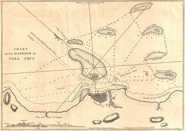
Chart of the Harbour of Vera Cruz.
$175.00
Acquire
- Digital Map Information
- Suitable for large format printing
- DPI: 300
- File Size: 4.91 MB
- File Type: ZIP / TIFF
- ICC color profile embedded
- Delivered instantly via download link
A fine 1809 nautical chart of the Harbor of Veracruz, Mexico by the American nautical chart publisher Eli Blunt. This map identifies the Reef of the Gallician, Island of Sacrifices, Green Island, ... (more details)
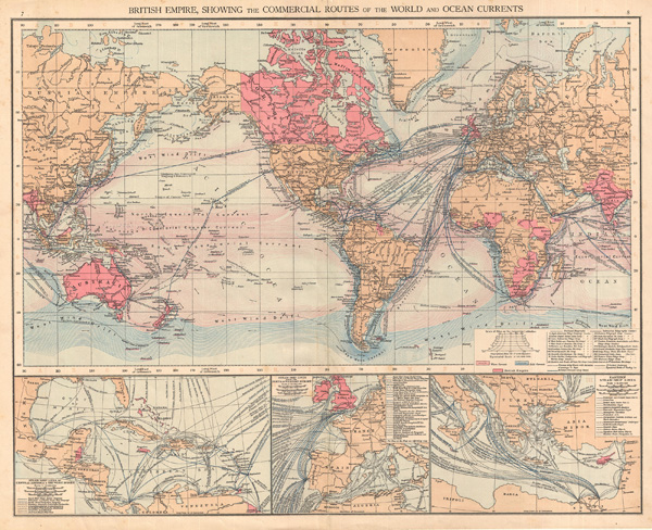
British Empire, showing the commercial routes of the world and ocean currents
sold
- Digital Map Information
- Suitable for large format printing
- File Size: 16.94 MB
- File Type: ZIP / TIFF
- ICC color profile embedded
- Delivered instantly via download link
This beautiful colored map of the British Empire in 1895 show the commercial routes of the world and ocean currents. Includes three insets detailing steamship lines in 1) Central America & the ... (more details)