
“Scientific cartography of the Territory of Utah may be said to date from the appearance of this map”-C. I. Wheat
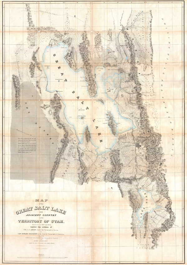
Map of the Great Salt Lake and Adjacent Country in the Territory of Utah.
sold
- Digital Map Information
- Suitable for large format printing
- DPI: 300
- File Size: 41.47 MB
- File Type: ZIP / TIFF
- ICC color profile embedded
- Delivered instantly via download link
It had been a daring feat of exploration, succeeding where the mountain men had all failed, and by means of his map of the western portion of the lake, Stansbury had painted at least one more bold stroke into the unfinished portrait of the national landscape. - ... (more details)
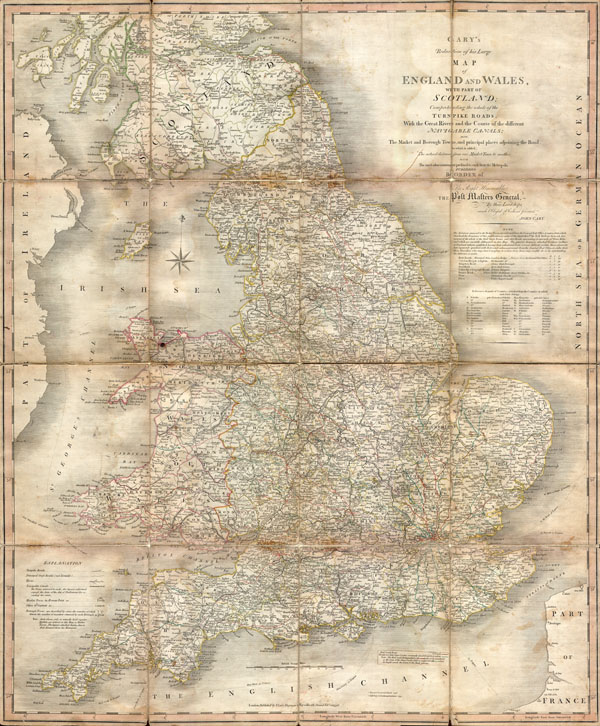
Cary’s Reduction of his Large Map of England and Wales, with part of Scotland; Comprehending the whole of the Turnpike Roads, With the Great Rivers and the Course of the different Navigable Canals: also The Market and Borough Town, and principal places adjoining the Road. To which is added, the Actual distance from one Market Town to another, with The exact admeasurement prefixed to each from the Metropolis. Published by Order of, and Dedicated with Permission to The Right Honorable the Post Masters General, by their Lordships, much Obliged & Obedient Servant, John Cary.
sold
- Digital Map Information
- Suitable for large format printing
- DPI: 300
- File Size: 20.42 MB
- File Type: ZIP / TIFF
- ICC color profile embedded
- Delivered instantly via download link
An important 1796 Case Map of England, Wales and the Southern part of Scotland by John Cary. This is in fact a reduction of Cary's seminal and enormous large format map of England and Wales produced a few years previously. Map depicts the region in impressive ... (more details)
Possibly the most beautiful map of Cook's travels in the Arctic.
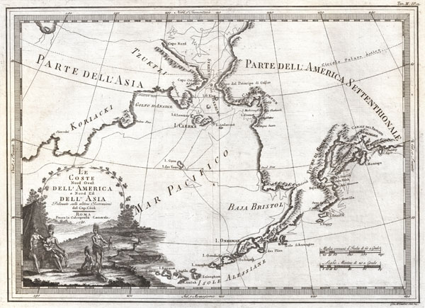
Le Coste Nord Ovest Dell' America e Nord Est Dell' Asia Delineate sulle ultime Osservazioni del Cp. Cook.
sold
- Digital Map Information
- Suitable for large format printing
- DPI: 300
- File Size: 9.03 MB
- File Type: ZIP / TIFF
- ICC color profile embedded
- Delivered instantly via download link
An extraordinarily fine example of Cassini's 1798 map of Alaska, the Bering Strait, and Siberia. Cassini issued this map in his 1798 atlas to illustrate the discoveries made by James Cook. Cook was the first to accurately chart the Alaskan coastline and ... (more details)
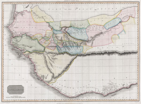
Western Africa
sold
- Digital Map Information
- Suitable for large format printing
- DPI: 300
- File Size: 7.52 MB
- File Type: ZIP / TIFF
- ICC color profile embedded
- Delivered instantly via download link
This fascinating hand colored 1813 map by Edinburgh cartographer John Pinkerton depicts Western Africa. Depicts Africa roughly from the Salve Coast and Gold coast west through the Ivory Coast, Guinea, the Gambia and north past Cape Verde as far as ... (more details)
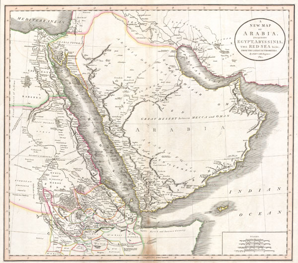
A New Map of Arabia, including Egypt, Abyssinia, the Red Sea & c. & c. from the latest Authorities.
sold
- Digital Map Information
- Suitable for large format printing
- DPI: 300
- File Size: 8.76 MB
- File Type: ZIP / TIFF
- ICC color profile embedded
- Delivered instantly via download link
This is a stunning 1811 map of Arabia, Egypt and Abyssinia ( Ethiopia ) by English Cartographer John Cary. A smorgasbord of wonderful detail including historical notes, caravan routes, the locations of desert wells and oases, nautical routes, and ... (more details)

Sketch B (bis) Sketch showing the positions of the Buoys placed in Delaware Bay & River under the direction of the Superintendent U.S.C.S. By Lieuts. Com. J. R. Goldsborough & R. Bache U.S. Navy, 1847.
sold
- Digital Map Information
- Suitable for large format printing
- DPI: 300
- File Size: 6.3 MB
- File Type: ZIP / TIFF
- ICC color profile embedded
- Delivered instantly via download link
A unusual triangulation chart of the Delaware Bay from the scarce 1848 edition of the Superintendent's Report . Covers from Cape May and Cape Henlopen northwards along the Delaware River past Wilmington and Philadelphia as far as Trenton. Shows ... (more details)
Speculative course of the Niger River w/ apocryphal Mountains of Kong.
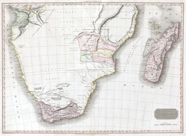
Southern Africa.
sold
- Digital Map Information
- Suitable for large format printing
- DPI: 300
- File Size: 7.82 MB
- File Type: ZIP / TIFF
- ICC color profile embedded
- Delivered instantly via download link
This fascinating hand colored 1809 map by Edinburgh cartographer John Pinkerton depicts Southern Africa. Covers Africa from Angola south to the Cape Colony (modern South Africa) and east to the Kingdom of Mongall (modern day Mozambique) and the ... (more details)

Sketch A Showing the Progress in Section No. 1 U.S. Coast Survey in 1844 - 45 - 46 - 47 & - 48
sold
- Digital Map Information
- Suitable for large format printing
- DPI: 300
- File Size: 7.21 MB
- File Type: ZIP / TIFF
- ICC color profile embedded
- Delivered instantly via download link
A unusual triangulation chart of the New England coast line from the scarce 1848 edition of the Superintendent's Report . Covers from Nantucket and Marthas Vineyard north past Cape Code and Boston as far as Portland, Maine. Shows various ... (more details)

Carte des Principales Montagnes du Globe.
sold
- Digital Map Information
- Suitable for large format printing
- DPI: 300
- File Size: 19.04 MB
- File Type: ZIP / TIFF
- ICC color profile embedded
- Delivered instantly via download link
This is a stunning 1825 comparative chart of the world's mountains. Divided into the Western Hemisphere mountains ( on the left ) and the mountains of the Eastern Hemisphere ( on the right ). Also includes the relative elevations of ... (more details)
Important second edition of Mercator and Hondius' Map of the Arctic showing a break with 16th century cartographic convention.
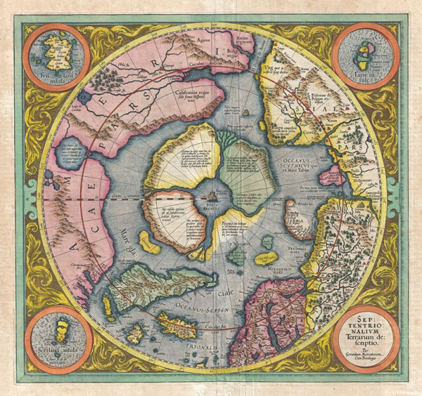
Septentrionalium Terrarum descriptio.
sold
- Digital Map Information
- Suitable for large format printing
- DPI: 300
- File Size: 10.52 MB
- File Type: ZIP / TIFF
- ICC color profile embedded
- Delivered instantly via download link
This is the second edition of Gerard Mercator's map of the North Pole or Arctic, one of the great cartographer's most interesting and important maps. Mercator's Arctic projection has its roots in his magnificent 1569 wall map of the ... (more details)
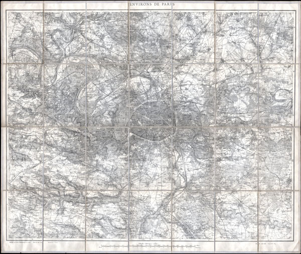
Environs de Paris 80.000e.
sold
- Digital Map Information
- Suitable for large format printing
- File Size: 27.39 MB
- File Type: ZIP / TIFF
- ICC color profile embedded
- Delivered instantly via download link
This is a splendid large size case map of Paris, France, and its environs prepared by the French Service Geographique de L'Armee. Extends from Vigny in the northwest to Rambouillet in the southwest to Marchemoret in the northeast ... (more details)
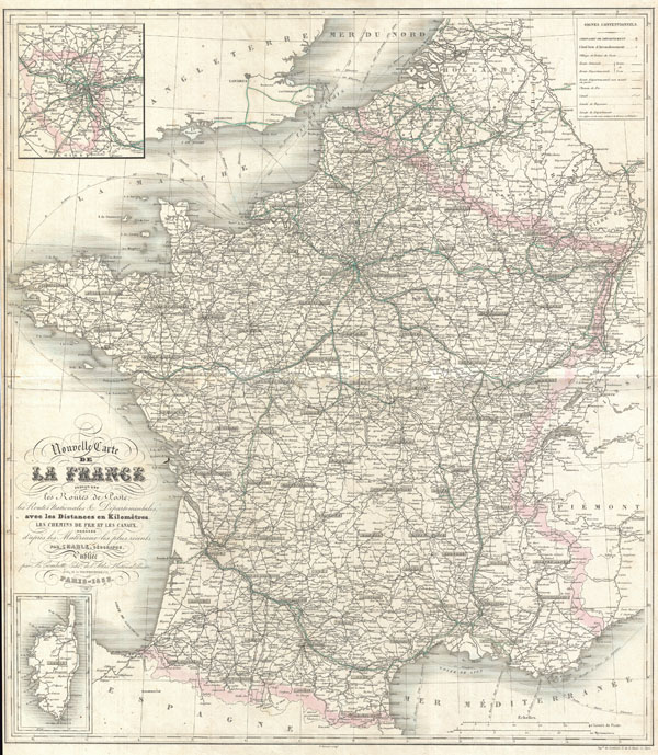
Nouvelle Carte del La France indiquant les Routes de Poste, les Routes Nationales & Departmentales aved les Distances en Kilometres.
sold
- Digital Map Information
- Suitable for large format printing
- DPI: 300
- File Size: 68.08 MB
- File Type: ZIP / TIFF
- ICC color profile embedded
- Delivered instantly via download link
This is a folio format map of France issued with Victor Levasseur's 1852 Atlas National Illustre . Covers all of France as well as adjacent parts of Italy, Span, and England. Shows all Departments as well as postal routes, major ... (more details)

Carte Générale de l'Ile de St. Domingue.
sold
- Digital Map Information
- Suitable for large format printing
- DPI: 300
- File Size: 16.83 MB
- File Type: ZIP / TIFF
- ICC color profile embedded
- Delivered instantly via download link
This is a rare and enormous 1797 Tardieu map of the Champagne region of France. Printed during the French Revolution - an 6 de la Republique. Covers from Paris in the west to Sarre-Louis in the east, from Rocroi in the north to ... (more details)
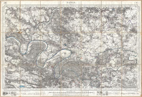
Paris.
sold
- Digital Map Information
- Suitable for large format printing
- File Size: 37.94 MB
- File Type: ZIP / TIFF
- ICC color profile embedded
- Delivered instantly via download link
An exceptionally attractive military plan of Paris dating to 1886. Issued by the French mapping bureau, the Depot de la Guerre, this extremely detailed chart covers the vicinity of Paris from the Foret de Carnelle in the north ... (more details)

Daniae Regnum
sold
- Digital Map Information
- Suitable for large format printing
- Full resolution TIFF file
- ICC color profile embedded
- Delivered instantly via download link
This is a spectacular and 1770 Lotter map of the Kingdom of Denmark. Formally titled 'Daniae Regnum.' Features an elaborate title cartouche bearing the Danish royal crest. Includes parts of modern day Sweden and ... (more details)
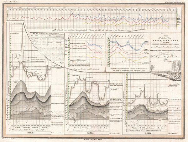
Die Deutschen Strome Rhein, Elbe; nach ihrem Verhalten Innerhalb Eines Jahres; gegrundet auf die Beobachtungen der Pegel zu Emmerich, Koln; Magdeburg, Dresden; Kustrin.
sold
- Digital Map Information
- Suitable for large format printing
- DPI: 300
- File Size: 6.64 MB
- File Type: ZIP / TIFF
- ICC color profile embedded
- Delivered instantly via download link
This is an unusual 1838 statistical chart by H. Berghaus. Offers a wealth of statistical information on the Rhine, Elbe, and Oder Rivers. Published as part of Berghaus's, Physikalischer Atlas , a monumental ... (more details)

State of Florida.
sold
- Digital Map Information
- Suitable for large format printing
- Full resolution TIFF file
- ICC color profile embedded
- Delivered instantly via download link
This hand colored map is a copper plate engraving, dating to 1849 by the legendary American Mapmaker S.A. Mitchell, the elder. It represents the state of Florida. This historically important map is extremely ... (more details)

Algerie, Colonie Francaise.
sold
- Digital Map Information
- Suitable for large format printing
- DPI: 300
- File Size: 10.44 MB
- File Type: ZIP / TIFF
- ICC color profile embedded
- Delivered instantly via download link
This is a fascinating 1852 Levasseur map of the French colony of Algeria. Shows the region divided into the administrative provinces of Oban, Alger, and Constantine. The map proper is surrounded by ... (more details)

British India, Southern Part.
sold
- Digital Map Information
- Suitable for large format printing
- Full resolution TIFF file
- ICC color profile embedded
- Delivered instantly via download link
This fascinating hand colored 1814 map by Edinburgh cartographer John Thomson depicts southern India. Covers from Bombay in the North to the northern part of Ceylon or Sir Lanka. Map is color coded ... (more details)
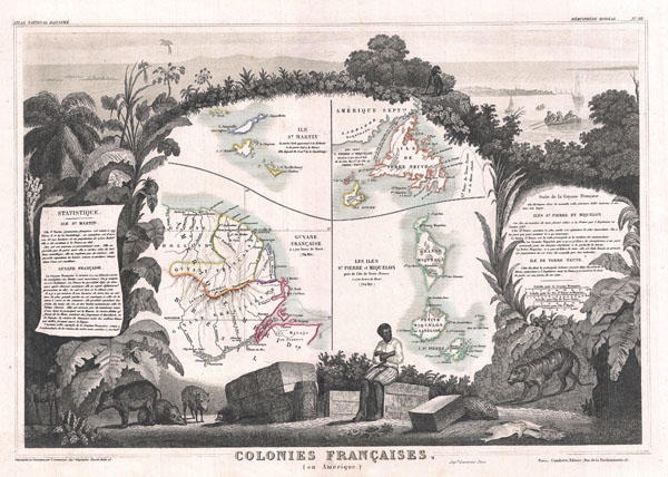
Colonies Francaises (en Amerique).
sold
- Digital Map Information
- Suitable for large format printing
- DPI: 300
- File Size: 8.8 MB
- File Type: ZIP / TIFF
- ICC color profile embedded
- Delivered instantly via download link
This is a fascinating 1852 Levasseur map of the French Colonies in America, including French Guyana, Newfoundland (not part of Canada), Miquelon and St. Pierre, and St. Martin. Miquelon and St. ... (more details)