
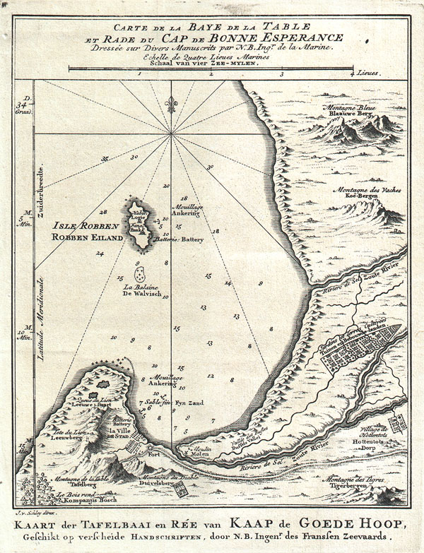
Carte de la Baye de la Table et Rade du Cap de Bonne Experance Dressee sur Divers Manuscrits par N. B. Ing' De la Marine. / Kaart der Tavelbaai en Ree van Kaap de Goede Hoop, Geschikt op verscheide Handschriften, door N.B. Ingenr. Des Franssen Zeevaards.
sold
- Digital Map Information
- Suitable for large format printing
- Full resolution TIFF file
- ICC color profile embedded
- Delivered instantly via download link
This map is a c. 1773 map of the Cape of Good Hope and Cape Town, South Africa. Attributed to French cartographer Jacques-Nicholas Bellin, this map was issued for the Dutch edition of Provost's Histoire des Voyages…. Beautifully rendered mountains and villages ... (more details)

Johnson's World on Mercators Projection.
sold
- Digital Map Information
- Suitable for large format printing
- File Size: 19.3 MB
- File Type: ZIP / TIFF
- ICC color profile embedded
- Delivered instantly via download link
This is A. J. Johnson's fine map of the world on Mercator's Projection. Depicts the entire world centered on North and South America. Offers a fascinating snapshot of the world during a period of rapid globalization and discovery. Updated from earlier ... (more details)

Gall & Inglis' Pocket Map of the Suburbs of London.
sold
- Digital Map Information
- Suitable for large format printing
- File Size: 17.41 MB
- File Type: ZIP / TIFF
- ICC color profile embedded
- Delivered instantly via download link
This is an attractive map of London, England, and its suburbs by Gall and Inglis. Dates to around the turn of the century (1900). Map offers considerable, even to the level of individual buildings. Labels important towns, stations, parks, and ... (more details)

Nikko
sold
- Digital Map Information
- Suitable for large format printing
- File Size: 18.57 MB
- File Type: ZIP / TIFF
- ICC color profile embedded
- Delivered instantly via download link
This is an extremely attractive c. 1901 Japanese view of Nikko, Japan. Covers the city center and surrounded by images of Nikko's most beautiful destinations. Smaller black and white view of the entire city, including the train station, below ... (more details)
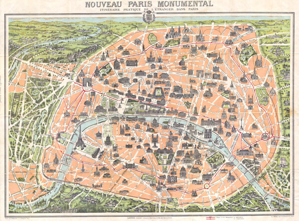
Nouveau Paris Monumental itineraire Pratique de L’Etranger Dans Paris.
sold
- Digital Map Information
- Suitable for large format printing
- Full resolution TIFF file
- ICC color profile embedded
- Delivered instantly via download link
This rare c. 1900 pocket map of Paris, France, combines the virtues of a map and a view. Covers the old walled city of Paris and surrounding areas. Paris proper is colored in appealing pastels and exhibits more 'map-like' qualities in the ... (more details)
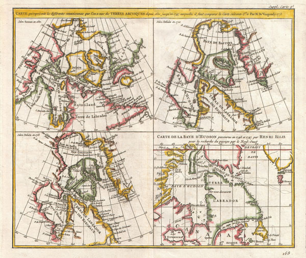
CARTE qui represente les différentes connoissances que l’on a eues des TERRES ARCTIQUES depuis 1650 jusqu’en 1747 ausquelles il faut comparer la Carte suivante Cte 10 Par M de Vaugondy 1773
sold
- Digital Map Information
- Suitable for large format printing
- Full resolution TIFF file
- ICC color profile embedded
- Delivered instantly via download link
This is a fascinating combination of four contrasting maps of the same area a single sheet. All four maps cover the northeastern part of America and Greenland, including the Hudson, Button and Baffin Bay regions, the Davis Straits and the ... (more details)

Colton's New York and Adjacent Cities.
sold
- Digital Map Information
- Suitable for large format printing
- File Size: 21.08 MB
- File Type: ZIP / TIFF
- ICC color profile embedded
- Delivered instantly via download link
This is a beautiful J. H. Colton map of New York City and vicinity, including Manhattan as well as parts of Brooklyn, Jersey City, Hoboken, and Queens. This is the third state of the Colton New York City map in which Central Park is ... (more details)
1833 School Girl Manuscript Wall Map of the World on Hemisphere Projection (Marcia Rounds of Newport

The World by Marcia Rounds, Newport 1833.
sold
This stunning schoolgirl map was hand drawn by Marcia Rounds of Newport Rhode Island in 1833. Covers the entire world on a hemisphere projection. Four smaller globes surrounding the main map describe longitude, latitude, and ... (more details)
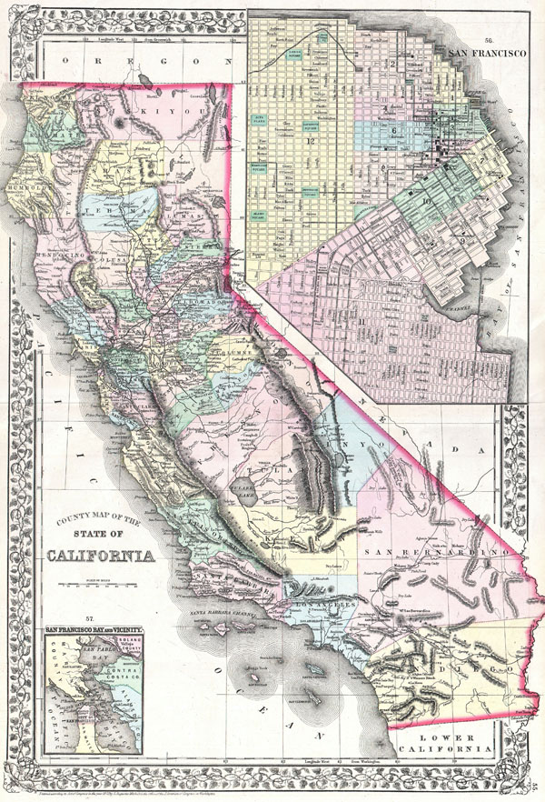
County Map of the State of California.
sold
- Digital Map Information
- Suitable for large format printing
- Full resolution TIFF file
- ICC color profile embedded
- Delivered instantly via download link
A beautiful example of S. A. Mitchell Jr.'s 1872 map of California and San Francisco. Detailed to the county level with attention towns, geographical features, proposed railroads, and cities. Upper right hand quadrant ... (more details)

Mappa totius mundi : adornata juxta observationes dnn. academiae regalis scientiarum et nonnullorum aliorum secundum annotationes recentissimas.
sold
- Digital Map Information
- Suitable for large format printing
- DPI: 300
- File Size: 21.58 MB
- File Type: ZIP / TIFF
- ICC color profile embedded
- Delivered instantly via download link
This is a stunning double hemisphere map of the world prepared by Guillaume De L'Isle and published by Tobias Conrad Lotter in 1775. The map consists of two central hemispheres, eastern and western, surrounded by smaller polar projections. Cartographically this map is altogether fascinating and exemplifies De L'Isle's careful scientific style of cartography. (more details)

Historical Map of Nantucket.
sold
- Digital Map Information
- Suitable for large format printing
- File Size: 5.94 MB
- File Type: ZIP / TIFF
- ICC color profile embedded
- Delivered instantly via download link
This attractive map is a reduced version of Reverend F. C. Ewers important 1869 map of Nantucket. This variant was issued by the Old Colony Rail Line in various formats from roughly 1872 to 1889. Covers the island of Nantucket in superb detail focusing on transportation and communities. Advertises the 'Old Colony Line' as the 'Shortest, Quickest, Best, and Only Direct Route between Boston or New York and Nantucket and Martha's Vineyard.' Also notes Native American claims to the Island. Features three columns of text breaking down the history of Nantucket from its discovery by Bartholomew Gosnold in 1602 to the laying of the first communications cables between Nantucket and the mainland in 1886. (more details)

Table of the Comparative Heights of the Principal Mountains & c. in the World.
sold
- Digital Map Information
- Suitable for large format printing
- DPI: 300
- File Size: 3.06 MB
- File Type: ZIP / TIFF
- ICC color profile embedded
- Delivered instantly via download link
This is Finley's attractive c. 1826 map of the comparative heights of the principal mountains of the world. Details the world's great mountains in relative proximity to one another and divided by continent. Each ... (more details)

Austria.
sold
- Digital Map Information
- Suitable for large format printing
- File Size: 6.72 MB
- File Type: ZIP / TIFF
- ICC color profile embedded
- Delivered instantly via download link
This rare hand colored map of Austria is a copper plate engraving dating to 1856. Produced by the important mid 19th century American map publisher J. H. Colton. Covers the Austria, Hungary, the Czech Republic ... (more details)
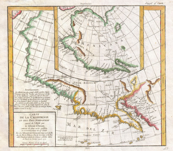
Carte De La Californie et Des Pays Nord-Ouest separes de L'Asie par le Detroit d'Anian, extraite de deux cartes publiees au commencement de 17e Siecle.
sold
- Digital Map Information
- Suitable for large format printing
- DPI: 300
- File Size: 6.62 MB
- File Type: ZIP / TIFF
- ICC color profile embedded
- Delivered instantly via download link
A very interesting 1772 map of the western part of North America by Vaugondy. Includes two contrasting maps, both drawn from larger 17th century maps by Visscher, covering from Cabo san Lucas northward along ... (more details)
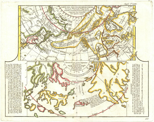
Carte Des Nouvelles Decouvertes dressee par Phil. Bauche Pr. Geograp? Du Roi presentee a l'Adad? Des Sciences le g Aout 1762 et approuvee dans son assemblee du 6 Septembre suivant. / Extrait d'une Carte Japonoise de L'Univers apportee en Europe par Kaempser et deposee dans le cabinet de seu Mr. Han-Sloane president de la Soceity Royale de Londres.
sold
- Digital Map Information
- Suitable for large format printing
- DPI: 300
- File Size: 6.48 MB
- File Type: ZIP / TIFF
- ICC color profile embedded
- Delivered instantly via download link
This is a fascinating combination of two contrasting maps on a single sheet. Both maps cover the northeastern parts of Asia and the northwestern parts of North America. This two map chart was originally ... (more details)
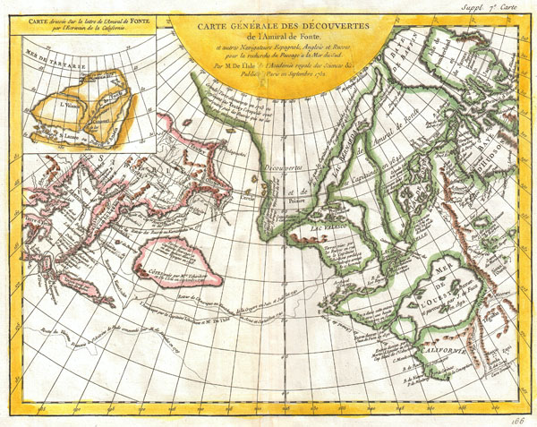
Carte Generale des Decouvertes de l'Amiral de Fonte et Autres Navigateurs Espagnols, Anglois et Russes pour la Recherche du Passage a la Mer du Sud.
sold
- Digital Map Information
- Suitable for large format printing
- DPI: 300
- File Size: 7.94 MB
- File Type: ZIP / TIFF
- ICC color profile embedded
- Delivered instantly via download link
One of the most splendid combinations of hard fact and speculative fantasy to appear in the history of cartography. This map, prepared by Joseph-Nicholas de L'Isle 1762 and republished by Vaugondy in ... (more details)
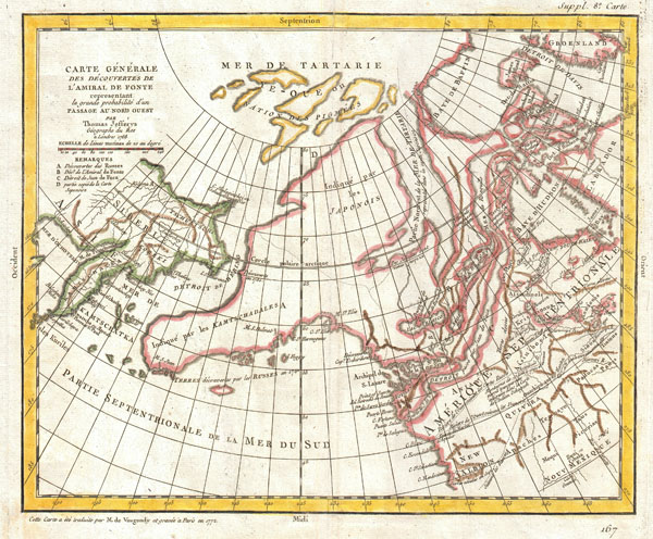
Carte Generale Des Decouvertes de L'Amiral de Fonte representant la grand porbabilite d'un Passage Au Nord Ouest par Thomas Jefferys Geographe du Roi a Londres 1768.
sold
- Digital Map Information
- Suitable for large format printing
- DPI: 300
- File Size: 7.1 MB
- File Type: ZIP / TIFF
- ICC color profile embedded
- Delivered instantly via download link
A truly fascinating 1772 map of the northwestern parts of North America by Robert de Vaugondy. Essentially depicts the north eastern parts of Asia, speculations on northwestern America and Admiral ... (more details)

Preliminary Chart No. 3 of the Sea Coast of the United States from Portland Maine to Race Point Mass.
sold
- Digital Map Information
- Suitable for large format printing
- File Size: 5.28 MB
- File Type: ZIP / TIFF
- ICC color profile embedded
- Delivered instantly via download link
A rare hand colored 1857 coastal chart of the Massachusetts coast line. Covers from Howland's Ledge (south of Boston) north through Boston Proper, Minot's Ledge, north past Nahaset, Lynn, Beverly, ... (more details)
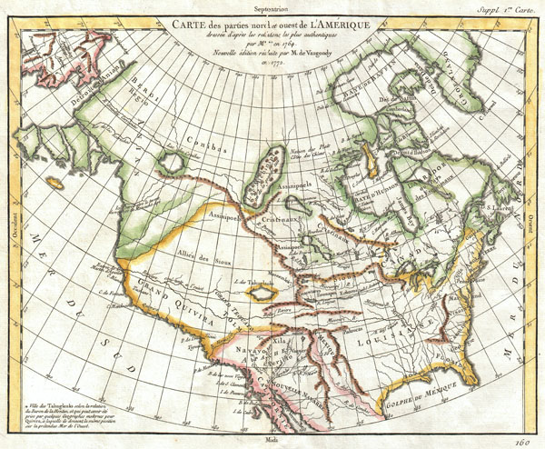
Carte des Parties Nord et Ouest de l'Amerique Dressee d'apres les Relations les Plus Authentiques par M *** en 1764.
sold
- Digital Map Information
- Suitable for large format printing
- DPI: 300
- File Size: 7.24 MB
- File Type: ZIP / TIFF
- ICC color profile embedded
- Delivered instantly via download link
A truly remarkable 1772 map of North America by Robert de Vaugondy. Based upon an earlier map of the region by Thomas Engel, this is a fascinating examination of the general layout and waterways ... (more details)

Carte de la Californie suivant / I. La carte manuscrite de l'Amérique de Mathieu Néron Pecci olen dresse à Florence en 1604 / II. Sanson 1656 / III. De L'Isle Amérique Sept. 1700 / IV. le Pere Kino Jesuite en 1705 / V. La Societe des Jésuites en 1767.
sold
- Digital Map Information
- Suitable for large format printing
- DPI: 300
- File Size: 6.85 MB
- File Type: ZIP / TIFF
- ICC color profile embedded
- Delivered instantly via download link
A rare and important map of California in five different states, ranging from roughly 1656 to 1767. Engraved by the important French cartographer Robert De Vaugondy, for the c. 1770 edition of ... (more details)