
Follows the events of the Federalist Revolution in Rio Grande do Sul, Brazil.

Mappa da viagem de ida e volta nos 3 Estados do Sul do Brazil do revolucionario Gomercindo Saraiva e lugar de sua morte.
sold
- Digital Map Information
- Suitable for large format printing
- File Size: 10.64 MB
- File Type: ZIP / TIFF
- ICC color profile embedded
- Delivered instantly via download link
This is an 1894 José Scutari map of southern Brazil during the Federalist Revolution (1893 - 1895). Using dashed red lines and arrows, Scutari traces the movements of insurrectionist forces under the command of Gomercindo Saraiva through the Brazilian states of Rio Grande do Sul, Santa Catharina, and Paraná. Twenty locations, battle sites and other important locations within these states, are identified both numerically and symbolically and chronicle Saraiva's participation in the revolution. An index situated in the bottom third of the map provides some details. In addition to the battles, location number twenty marks the site of Gomercindo Saraiva's death just before the Battle of Carovi. In an effort to provide the viewer with greater detail and context, cities, towns, and rivers throughout the region are also labeled. (more details)
A wonderful wall map of railroad routes in the western United States highlighting the Burlington Route.
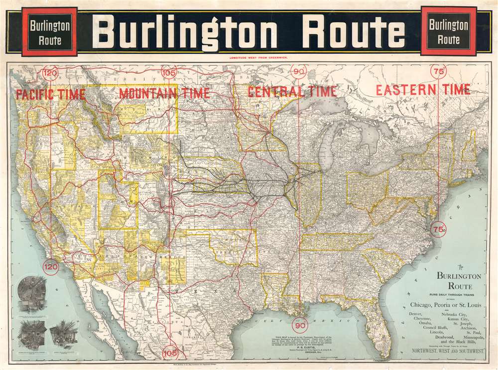
Burlington Route.
sold
- Digital Map Information
- Suitable for large format printing
- File Size: 98.5 MB
- File Type: ZIP / TIFF
- ICC color profile embedded
- Delivered instantly via download link
This is an 1892 large format Rand McNally map of the United States highlighting the route of the Chicago, Burlington and Quincy Railroad, commonly known as the Burlington Route. While the map covers the entire United States, the real focus are the routes extending westward from Chicago to, pretty much, the entire country. The Burlington Route is highlighted in black and many of its subsidiaries, including the Burlington and Missouri River Railroad, are also labeled. Stops along all the Burlington routes are also identified. Other major railroads in the western United States are highlighted in red, such as the Northern Pacific, Union Pacific, and Southern Pacific. Interior views in the lower left, illustrate the commodious accomiditions onboard the Burlington Route Pullman Palace Sleeping Car, passenger chair car, and dining car. (more details)
Records the American occupation of Cuba following the Spanish-American War.
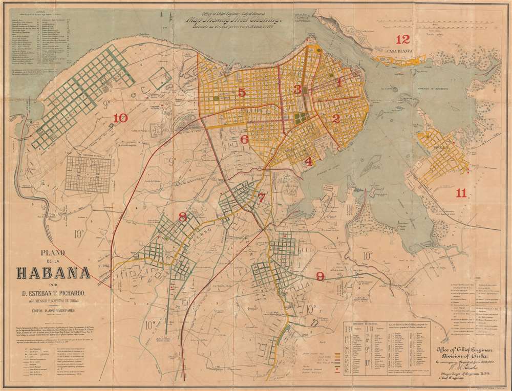
Office of Chief Engineer - City of Havana. Map Showing Street Cleaning. Districts as divided previous to March 1, 1900. Plano de la Habana por D. Estéban T. Pichardo, Agrimensor y Maestro de Obras.
sold
- Digital Map Information
- Suitable for large format printing
- File Size: 72.97 MB
- File Type: ZIP / TIFF
- ICC color profile embedded
- Delivered instantly via download link
Created during the U.S. occupation of Havana following the Spanish-American War, this is William Murray Black's 1900 city plan or map of Havana, Cuba. The map is part of a series highlighting efforts by the Americans to increase sanitation in the city, with the present example detailing street cleaning. With content in both English and Spanish, the map depicts the city from the Rio la Chorrera to Regla and Morro Castle (Castillo del Morro) at the entrance to Havana Bay, to Vibora. (more details)
An important Great Lakes Map showing the straits between Lake Superior, Lake Huron, and Lake Michigan.
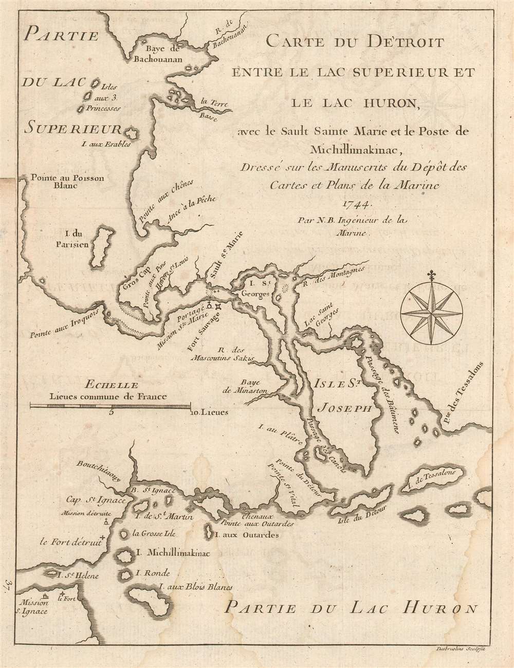
Carte du Detroit entre le Lac Superieur et le Lac Huron, ave le Sault Sainte Marie et la Poste de Michillimakinac, Dresse sur les Manuscrits du Depot des Cartes et Plans de la Marine.
sold
- Digital Map Information
- Suitable for large format printing
- DPI: 600
- File Size: 2.79 MB
- File Type: ZIP / TIFF
- ICC color profile embedded
- Delivered instantly via download link
This is a handsome example of Bellin's scarce 1744 map illustrating the straits between Lake Superior, Lake Huron, and Lake Michigan. The map covers from Batchawana Bay (Baye de Bachouanan) south to Whitefish Bay past Ille Parisienne to the St. Mary's River, which it follows inland, passing the Mission of St. Marie, Fort Sauvage, and Surgar Island (I. St. Georges) to the Isle St. Joseph and Lake Huron. It then follows westward as far as Bois Blanc Island and Point St. Ignace and the entrance to Lake Michigan. This is the same passage through which the United States-Canada border now runs.
Bellin originally prepared this map to illustrate Pierre François Xavier de Charlevoix's Histoire et description generale de la Nouvelle France, one of the most comprehensive works on North America predating the French and Indian War. Charlevoix was a Jesuit missionary and traveler commissioned by the French Crown and the Duke of Orleans to explore French holdings in the Americas, particularly with a view towards finding a profitable route to the Pacific. Many hoped this in the network of rivers and lakes to the west of the Great Lakes, as suggested by earlier explorers and mapmakers such as Lahontan and De l'Isle. It was engraved by Desbruslins Fils of Paris. Charlevoix's history thus proved exceptionally influential as one of the most comprehensive works on North America predating the French and Indian War. (more details)
Bellin originally prepared this map to illustrate Pierre François Xavier de Charlevoix's Histoire et description generale de la Nouvelle France, one of the most comprehensive works on North America predating the French and Indian War. Charlevoix was a Jesuit missionary and traveler commissioned by the French Crown and the Duke of Orleans to explore French holdings in the Americas, particularly with a view towards finding a profitable route to the Pacific. Many hoped this in the network of rivers and lakes to the west of the Great Lakes, as suggested by earlier explorers and mapmakers such as Lahontan and De l'Isle. It was engraved by Desbruslins Fils of Paris. Charlevoix's history thus proved exceptionally influential as one of the most comprehensive works on North America predating the French and Indian War. (more details)
A wonderful map highlighting the forests of the Rocky Mountains.
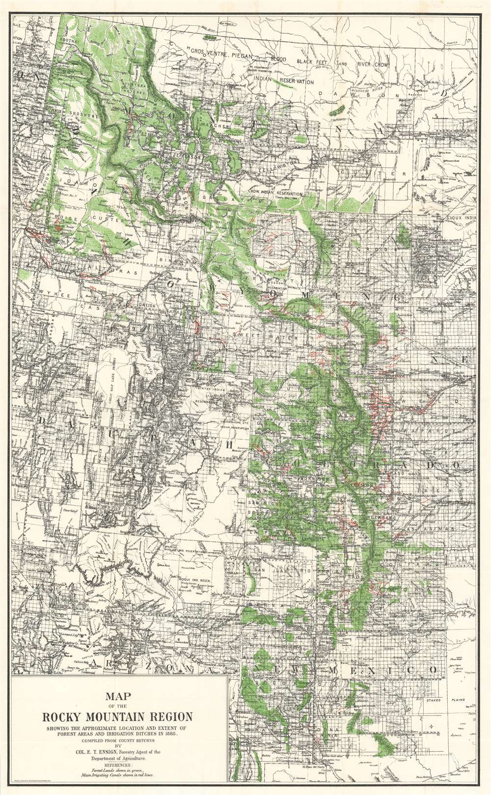
Map of the Rocky Mountain Region Showing the Approximate Location and Extent of Forest Areas and Irrigation Ditches in 1885.
sold
- Digital Map Information
- Suitable for large format printing
- File Size: 43.78 MB
- File Type: ZIP / TIFF
- ICC color profile embedded
- Delivered instantly via download link
This is an 1888 Edgar Ensign map of the Rocky Mountain region that highlights forested areas and irrigation ditches. The forests are shaded green, allowing the viewer an overall view of the of the distribution of forested land from the Canadian border south to Texas. The small red lines present throughout mark irrigation ditches, with a particular concentration appearing the watershed draining into the South Platte River in Colorado. Counties are labeled throughout, as are numerous cities and towns. The township grid of the Public Land Survey System, complete with numbers for the townships and ranges, covers the majority of the map, with exceptions including heavily mountainous terrain, national parks, and Indian reservations. (more details)
The first map made by Chinese Americans of San Francisco for the Chinese community.
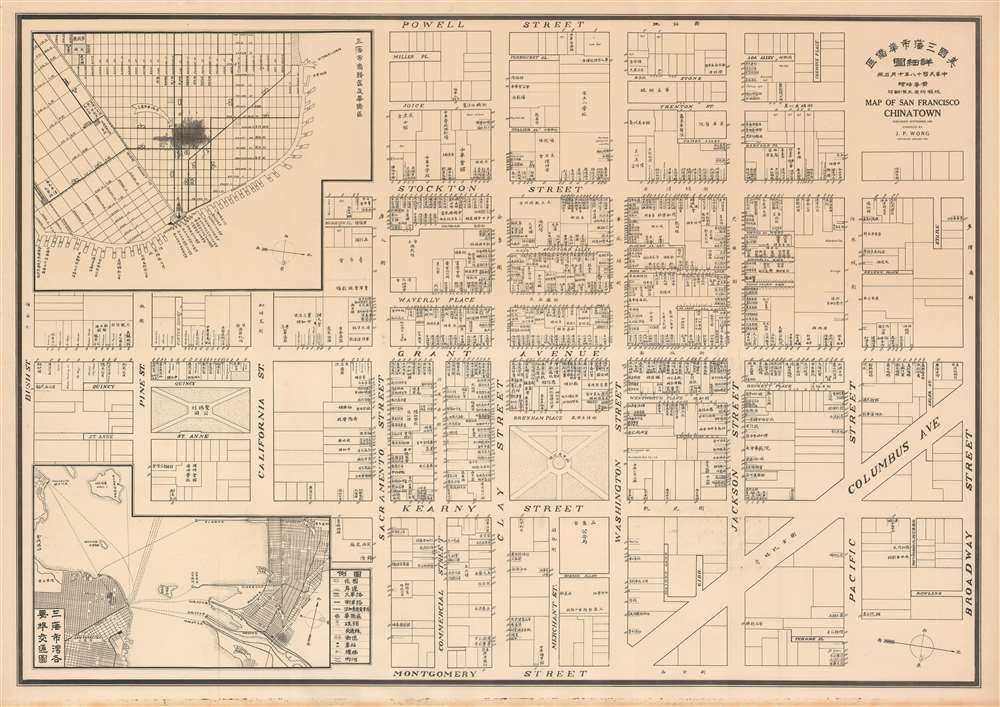
Map of San Francisco Chinatown. / 美國三藩市華僑區: 詳細圖 / Meiguo Sanfan Shi hua qiao qu : xiang xi tu.
sold
- Digital Map Information
- Suitable for large format printing
- File Size: 22.69 MB
- File Type: ZIP / TIFF
- ICC color profile embedded
- Delivered instantly via download link
An extraordinary record of the early 20th century Chinese experience in San Francisco, this is a rare 1929 map of San Francisco's Chinatown by the San Francisco based Kuomintang (KMT) nationalist J. P. Wong (黃華培, Huang Huapei). This is the first map of Chinatown to be produced by Chinese-Americans for Chinese-American use, and accordingly identifies primarily Chinese-owned businesses and organizations. The map was printed on behalf of the 'Chinese Six Companies' who used it to collect dues, but it was also used by the Tongs, criminal gangs who similarly employed the map to support their extortion racket. (more details)
Highlights everything that is the World's Biggest, Best, and Finest in Texas.

A Texan's Map of the United States [of Texas].
sold
- Digital Map Information
- Suitable for large format printing
- File Size: 24.15 MB
- File Type: ZIP / TIFF
- ICC color profile embedded
- Delivered instantly via download link
This is a rare 1949 Frank Oliver pictorial map of the United States from a Texan's point of view. Naturally, Texas dominates the majority of the continental U.S. and reaches from the Rio Grande River to the Canadian border, labeled simply as the Arctic Circle. The oversized depiction of Texas is filled with vignettes, all illustrating something that is the world's 'finest', 'best', or 'largest', all of which surrounds the land owned by TexOak Flooring Company, situated at the 'Heart of the World's Largest Pine and Oak Timberland'. Some of these vignettes tout aspects of life in Texas, such as Dallas as being home to the 'World's best dressed and most beautiful women'. Texas is also, apparently, home to the 'World's tallest people (and tales)', the 'World's most diversified weather', and 'Millionaires by the score'. Oliver also promotes Texas as possessing the world's 'finest cattle land', 'largest wheat fields', 'largest piece of private proppity', and the 'biggest and juiciest melons'. A farmer working the 'World's finest farmland' is illustrated telling his worker to 'Just hold the seed in your left hand and the. Sickle in your right… '. Perhaps the most amusing of these vignettes, however, references the open spaces of the Texas Panhandle and promotes the region as the 'World's best treatment for claustrophobia'. (more details)
A highly influential early map of the Americas.
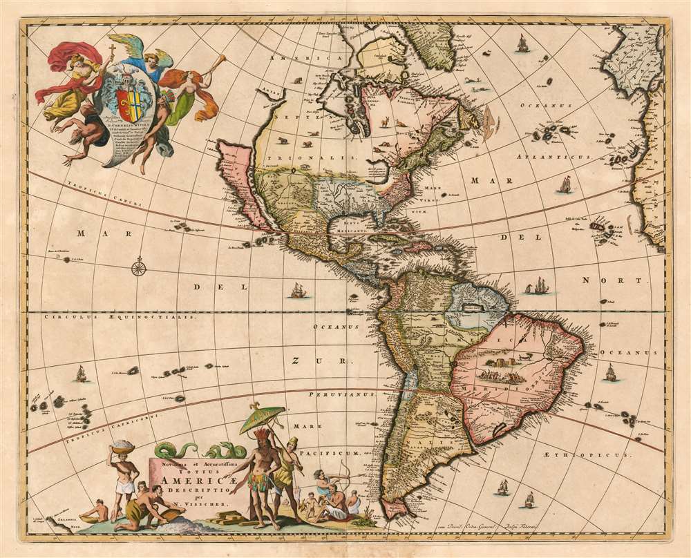
Novissima et accuratissima totius Americae Descriptio per N. Visscher
sold
- Digital Map Information
- Suitable for large format printing
- DPI: 600
- File Size: 35.24 MB
- File Type: ZIP / TIFF
- ICC color profile embedded
- Delivered instantly via download link
This is a c. 1677 example of Nicolas Visscher's 1658 map of America. The map embraces all of the New World, including part of the Atlantic coasts of Europe and Africa, and a scattering of Pacific Islands. This map would be hungrily copied by competing Dutch map publishers; it, itself was based on information drawn largely from the 1648 world map of Joan Blaeu. Thus Visscher's map would become the conduit for the spread of much of Blaeu's American geography throughout the map publishing world. By far this map's most strikinging cartographic elements deal with its unusual treatment of North America, with California represented as an island, the Great Lakes rendered as a single body of water open to the west, and the strait of Anian appearing far to the north. (more details)
A Chinese propaganda broadside touting the numerical victories of the Vietnamese over the Americans.
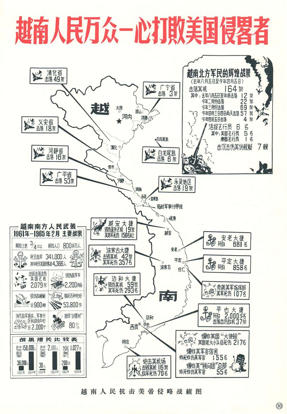
Record of the Vietnamese People's Fight Against American Imperial Aggression. / 越南人民抗击美帝国侵略战績图
sold
- Digital Map Information
- Suitable for large format printing
- File Size: 3.82 MB
- File Type: ZIP / TIFF
- ICC color profile embedded
- Delivered instantly via download link
This is a c. 1965 anti-American Chinese propaganda broadside map of Vietnam denouncing imperialism and celebrating Vietnamese victories over 'imperialist invaders'. Text boxes in both North and South Vietnam enumerate the deadly toll of these victories. The number of American planes shot down over North Vietnam is broken down by province, while the number of downed and damaged helicopters and the number of soldiers killed and wounded are highlighted in South Vietnam. Another text box situated in the upper right breaks down the statistics concerning American aircraft shot down between August 5, 1964 and April 5, 1965, with an overall count of 164. It also notes six pilots that were taken prisoner. The statistics included in the lower left summarize events from 1961 until 1965. It declares that three-quarters of South Vietnam, over 8 million, have been liberated. Below, there is are grislier numbers, including that 341,000 enemy troops killed, including 4,366 Americans, 2,079 aircraft shot down, and 53,800 weapons confiscated. The graphs in the lower left corner compare data from 1961 to 1964, including American troop numbers in South Vietnam, troops killed, and aircraft shot down. (more details)
Highlights three competing Codes of Commercial Signals.
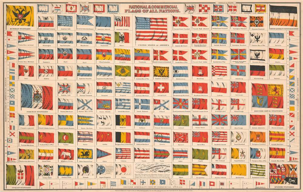
National and Commercial Flags of All Nations.
sold
- Digital Map Information
- Suitable for large format printing
- File Size: 24.85 MB
- File Type: ZIP / TIFF
- ICC color profile embedded
- Delivered instantly via download link
This is an 1868 George Woolworth Colton and Charles B. Colton chart of the flags of the world. Over one hundred different flags are illustrated, including several ephemeral ensigns, such as those of the Russian American Company, the United States of Colombia, and the Wallachian Merchant flag. Twelve different flags designating pilot boats are illustrated along the top border, which were useful signals for mariners navigating difficult harbors. (more details)
Chinese Communist Serio-Comic Propaganda!

Map of Current Situation in East Asia. / 时局图
sold
- Digital Map Information
- Suitable for large format printing
- File Size: 23.96 MB
- File Type: ZIP / TIFF
- ICC color profile embedded
- Delivered instantly via download link
This is an uncommon c. 1950 serio-comic propaganda map issued by the Chinese Communist Party during or just before the Cultural Revolution. The map co-opts an earlier pro-Chinese anti-colonial serio-comic map prepared in the late 19th century. Coverage includes all of China, as well as some of the surrounding territories in Southeast Asia, Japan, Korea, and Central Asia. Zoomorphic figures stand astride the cartography - each with a political message. Most of these are expounded upon in the Chinese text below the map proper. (more details)
Illustrates Havana at the apex of Cuban-American relations.

Panoramic and Monumental Map of Havana (Plano Panoramico y Monumental de La Habana).
sold
- Digital Map Information
- Suitable for large format printing
- Full resolution TIFF file
- ICC color profile embedded
- Delivered instantly via download link
This is a c. 1954 Rogelio L. Mirabal panoramic map of Havana, Cuba issued by the Cuban Tourist Commission, capturing the city at the height of its romantic literary period in the early fifties. The map depicts the city from Havana Bay to the Gulf of Mexico and from Rancho Boyeros International Airport to the Canal de Entrada. The Morro Castle, a fortress built at the entrance to Havana Bay, is partially illustrated in the lower right corner. Numerous buildings, monuments, and other locations throughout the city are depicted in profile, some of which, including the National Capitol building, police headquarters, Atares Castle, and Punta Castle, are identified by name. Other locations illustrated in this way are labeled numerically, and these numbers that correspond with a key situated along the map's right border, which also provides each site's grid location on the map. Neighborhoods throughout the city are labeled, as are major streets. An alphabetic street index is included along the left border. Piers along Havana's harbor are also illustrated and labeled, as are the routes of launches to Regla, Casa Blanca, and La Cabaña Fortress. (more details)
Early mapping of New York Subways.
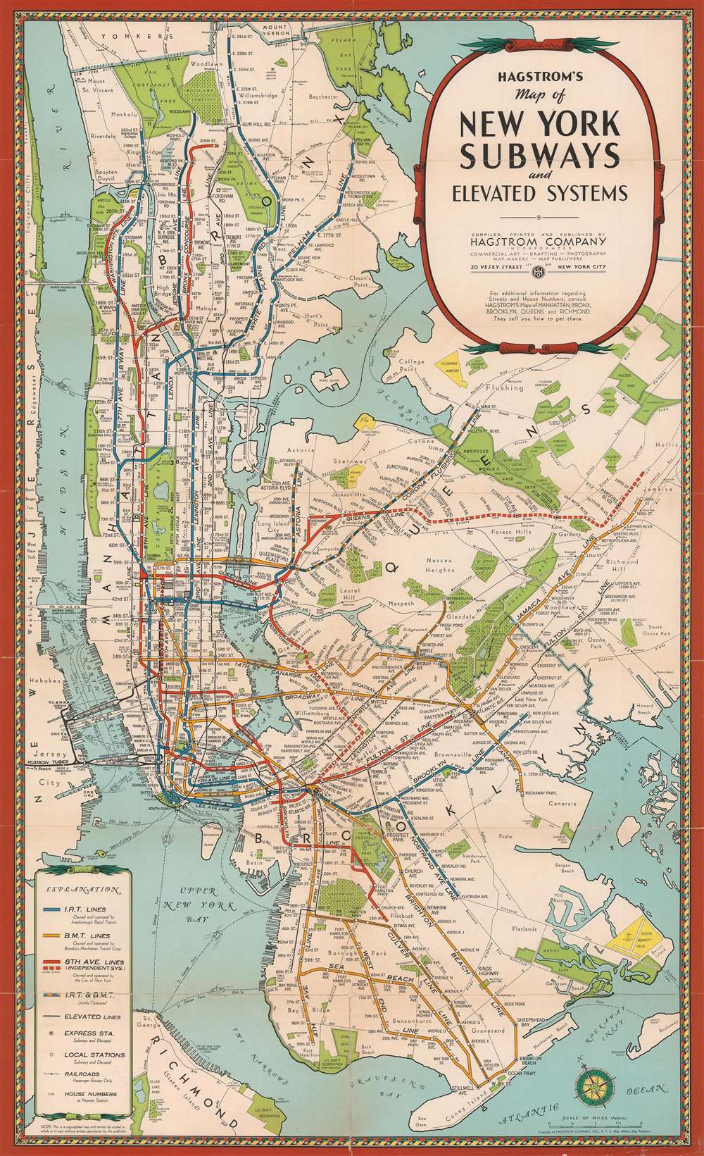
Hagstrom's Map of New York Subways and elevatd Systems.
sold
- Digital Map Information
- Suitable for large format printing
- Full resolution TIFF file
- ICC color profile embedded
- Delivered instantly via download link
An uncommon early c. 1939 edition of Hagstrom's map of New York City showing subways and elevated trains, including the BMT and IRT lines. The map covers most of New York City with the exception of Staten Island. Parks are detailed, as are major avenues and streets, but he focus of the map is the subway and transit lines. Color coding defines the lines, the IRT (blue), BMT (yellow), 8th Avenue line (Red), Joint lines (blue and yellow). The map also attempts to show major railway lines. This map is undated but predates the 1939 merger of the December 12, 1939 merger of the IRT, BMT, IND (independent lines), the largest railroad merger in U.S. history. (more details)
The Most Distant island Mapped in Ptolemy's Era

Tavola Duodecima Dell'Asia
$400.00
Acquire
- Digital Map Information
- Suitable for large format printing
- DPI: 600
- File Size: 4.52 MB
- File Type: ZIP / TIFF
- ICC color profile embedded
- Delivered instantly via download link
This is Giovanni Antonio Magini's map of Taprobana, appearing in his 1598 Italian edition of Ptolemy's Geographia. This island represented, for Ptolemy, nearly the limit of European geographic knowledge: later geographers typically identified the island as Sri Lanka, though Munster, Mercator and others speculated that the better candidate was Sumatra. The map is oriented to the north and includes not only ‘Taprobana’ but also twenty surrounding islands. The mainland appears above and on the right of the map, which would correspond to the Malay peninsula were the map correctly identified with Sumatra, although the map roughly adheres to Sri Lanka's teardrop shape. To the left of the map is an attractively-engraved illustration of an elephant, and eleven lines of text describing the pepper trade - explicitly identifying the island as Sumatra. Magini joins Gastaldi, and Ruscelli in following the model of Münster, whose version of this map in his own edition of Ptolemy contained these same elements.
Magini's Italian letterpress text below the engraved map describes the island, its people, and its produce. (more details)
Magini's Italian letterpress text below the engraved map describes the island, its people, and its produce. (more details)
Published soon after the end of the Second French Intervention in Mexico in 1867.
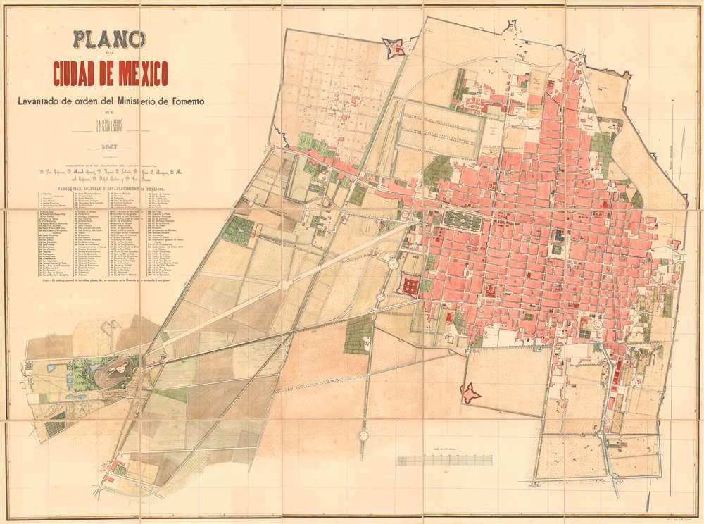
Plano de la Ciudad de Mexico.
sold
- Digital Map Information
- Suitable for large format printing
- File Size: 39.62 MB
- File Type: ZIP / TIFF
- ICC color profile embedded
- Delivered instantly via download link
Published following the 1867 Republican siege of Mexico City, this E. M. Segredo and Ministerio de Fomento (Ministry of Development) city plan or map of Mexico City depicts the recaptured capital of the restored Republic of Mexico. Some 125 parishes, churches, and other public establishments are numerically labeled throughout and correspond to an index below title. Converge extends from the Chapultepec castle in the lower left quadrant, along the Calzada Imperial (present day Paseo de Reforma), to the historic center of Mexico City. Of note is the planned expansion in the northeast, what is today Colonia Santa María la Ribera. The Chapultepec Castle and grounds, now a beautiful public park, was the shortly before this map as made, the seat of the Emperor Maximilian I, of the Second Mexican Empire. (more details)
Natucial chart with extensive annotation regarding Newburyport whaling voyages.

North Atlantic.
sold
- Digital Map Information
- Suitable for large format printing
- Full resolution TIFF file
- ICC color profile embedded
- Delivered instantly via download link
This is an uncommon 1874 James Imray and Son blueback nautical chart or maritime map of the North Atlantic with extensive whaling annotations relating to the voyages of Newburyport Captain John. N Pritchard. The map covers from the Equator and the mouth of the Amazon River to the southern shores of Greenland, and from the Gulf of Mexico to the Baltic Sea and Sardinia. The chart contains a wealth of nautical information regarding trade winds, oceanic depths, currents, and more. There are detailed inset maps of Bermuda, Fayal Channel (Faial-Pico Channel, Azores), Horta and Pim Bays (Azores), and Funchal Bay (Madeira). Some pencil marks and erasures suggest early maritime use in the vicinity of Bermuda. (more details)
An incredible 19th century view of London.

[London Illustrated New Panorama View of London and the River Thames].
sold
- Digital Map Information
- Suitable for large format printing
- DPI: 600
- File Size: 117.23 MB
- File Type: ZIP / TIFF
- ICC color profile embedded
- Delivered instantly via download link
This is a scarce 1845 London Illustrated News panorama of London, England. Measuring some 96 inches long, this enormous production presents a birds-eye view of London as seen from far above the southern shore of the Thames, covering from Vauxhall to Greenwich. There is much of interest throughout, from lively shipping at the East and West India Docks; to Nelson's Column, only erected three years before; to the short-lived Hungerford Suspension Bridge (1845-1862, when it was removed and the chain used on the Clifton Suspension Bridge over the Avon); and Buckingham Palace, completed in 1837, still with the Marble Arch as the gateway (re-erected in Hyde Park 1851). (more details)
The first American map about Coffee!
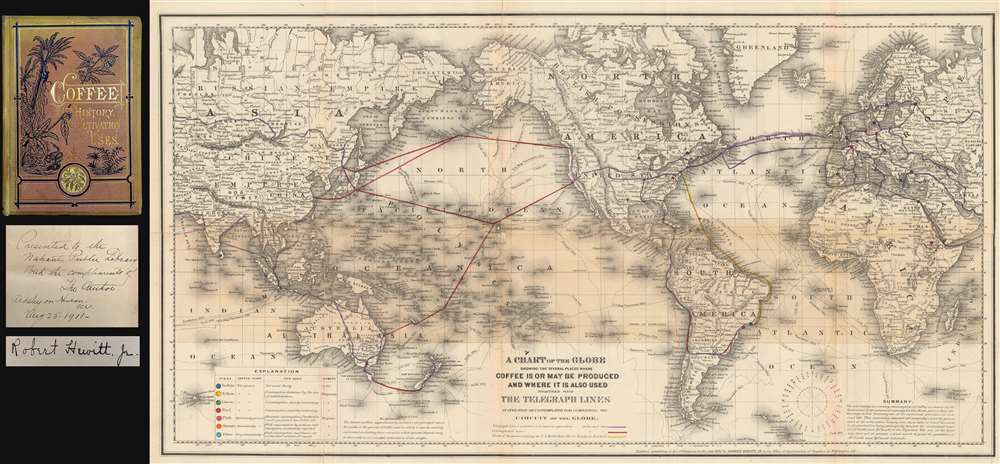
A Chart of the Globe Showing the Several Places Where Coffee is or May be Produced and Where it is also used together with The Telegraph Lines in operation or contemplated for completing the Circuit of the Globe.
sold
- Digital Map Information
- Suitable for large format printing
- File Size: 25.84 MB
- File Type: ZIP / TIFF
- ICC color profile embedded
- Delivered instantly via download link
A fascinating 1872 thematic map of the world by Robert Hewitt detailing the global production and traffic in coffee - considered the first American map related to Coffee - accompanied by a signed first edition of Hewitt's important book on coffee. Presented on Mercator's projection, the map dually identifies coffee production and consumption, and telegraph lines. A series of color codes referenced in the lower right breaks down the region according to the ability to grow and use coffee, and its rate of consumption, with places like Rio de Janeiro, Colombo (Sri Lanka), and Sumatra as centers of both production and consumption, places of increasing consumption, like Melbourne (Australia), the United States, places of limited consumption (mostly Scandinavian countries), and everything in between. (more details)
A wonderful pictorial map of the United States published just before America's entry into World War II.
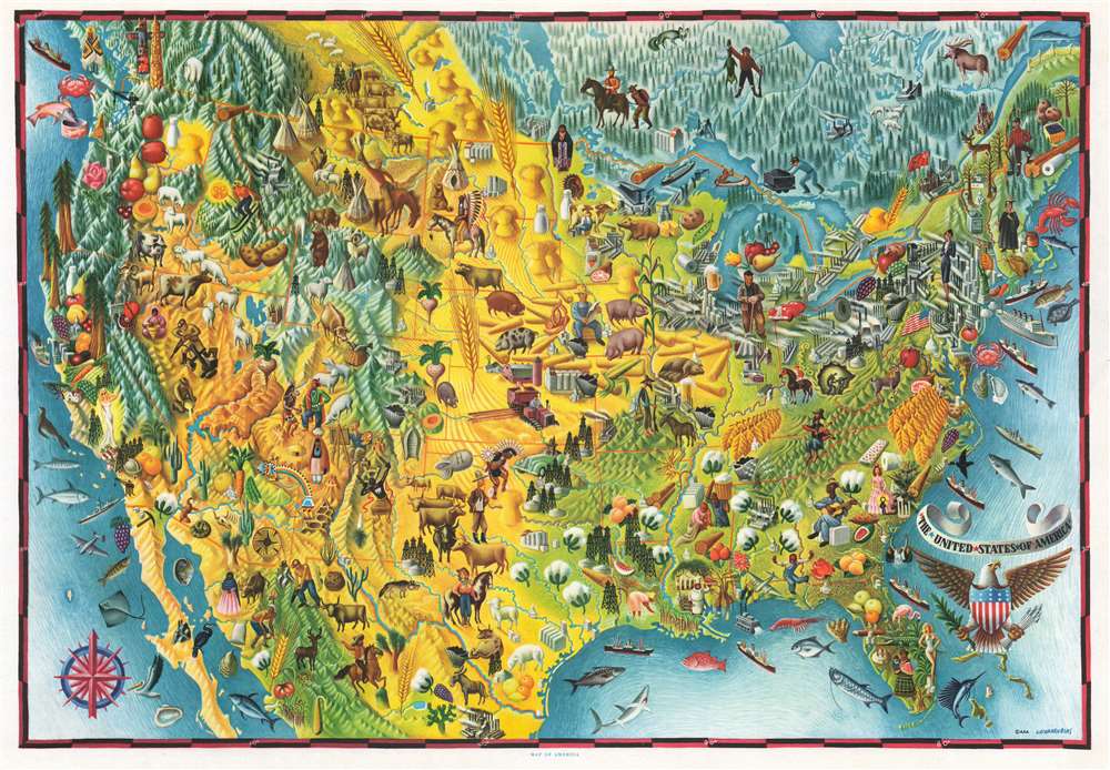
Map of America. / The United States of America.
sold
- Digital Map Information
- Suitable for large format printing
- File Size: 37.25 MB
- File Type: ZIP / TIFF
- ICC color profile embedded
- Delivered instantly via download link
This is a c. 1940 Miguel Covarrubias pictorial map of the United States. Wonderfully illustrated, Covarrubias employs motifs to convey regional differences throughout the country. The Northeast, for example, is filled with skyscrapers and steel mills, and its people are dressed elegantly in business attire, graduation robes, or in the clothes of a workman who operates machinery in a factory. The South is green and filled with fields full of tobacco and cotton, with the exception of Florida, then as now, is home to flamingos, alligators, and women in bathing suits. The Midwest practically glows yellow from the wheat and corn, highlighted by a farmer harvesting. A cowboy riding a bronco appears in eastern Montana, between groups of Native American teepees and a chief in ceremonial regalia. Skiers frolic in the Rocky Mountains beside bears, bighorn sheep, and mines. The Southwest is illustrated as a land of desert, with artists, pueblos, and its own Native American culture. Finally, the Pacific Coast is again lush and green, particularly the Pacific Northwest, where totem poles and salmon and highlighted. This, of course, is not to be outdone by the twin pillars of the redwoods and Hollywood glamour in California. (more details)
Includes profile views of the three isthmuses of Central America.
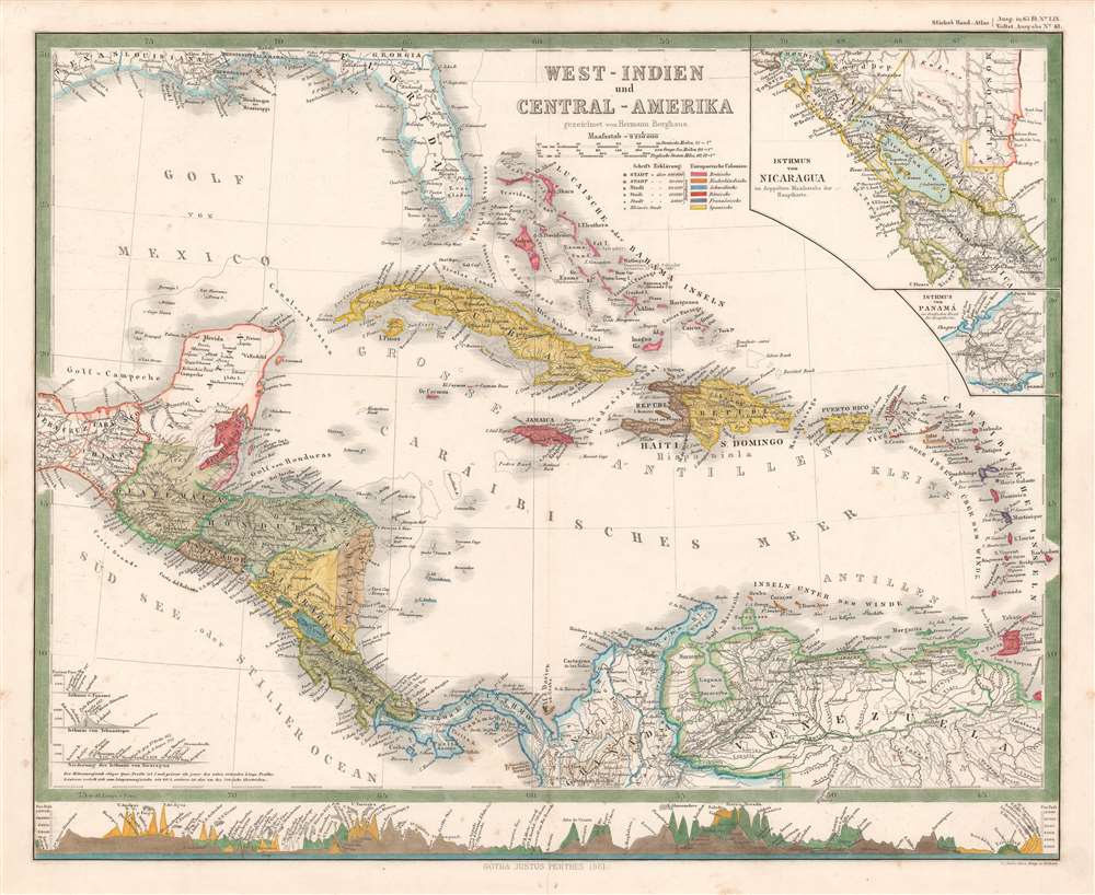
West-Indien und Central-Amerika.
sold
- Digital Map Information
- Suitable for large format printing
- File Size: 13.5 MB
- File Type: ZIP / TIFF
- ICC color profile embedded
- Delivered instantly via download link
A striking 1861 Hermann Berghaus map of the West Indies and Central America. The map depicts the region from the Tehuantepec Isthmus in Mexico to the Leeward Islands and from the Gulf Coast of the United States to northern South America. Published near the height of the mid-19th century European race for colonial acquisition, six different colors are used to highlight British, French, Dutch, Spanish, Danish, and Swedish colonies. The only Swedish colony in the Caribbean at the time was Saint Barthelemy, a small island near Anguilla, Saint Martin, and Barbuda, although it is not correctly colored. An inset map in the upper right corner details the Isthmus of Nicaragua, highlighting the roads throughout the region, particularly along the Pacific coast. An inset of the Isthmus of Panama is included just below the one of Nicaragua and presents in detail the rail line constructed across the isthmus from Colon to Panama City, one of the preferred ways to transfer goods from the Atlantic to the Pacific before the construction of the Panama Canal. There are profile illustrations of the Isthmuses of Panama, Nicaragua, and Tehuantepec in southern Mexico, all three of which were used to transfer goods across Central America, and all three of which were being promoted as potential options for an inter-oceanic canal. (more details)