
Early map showing a distorted Lake Michigan and the site of the Black Hawk War.
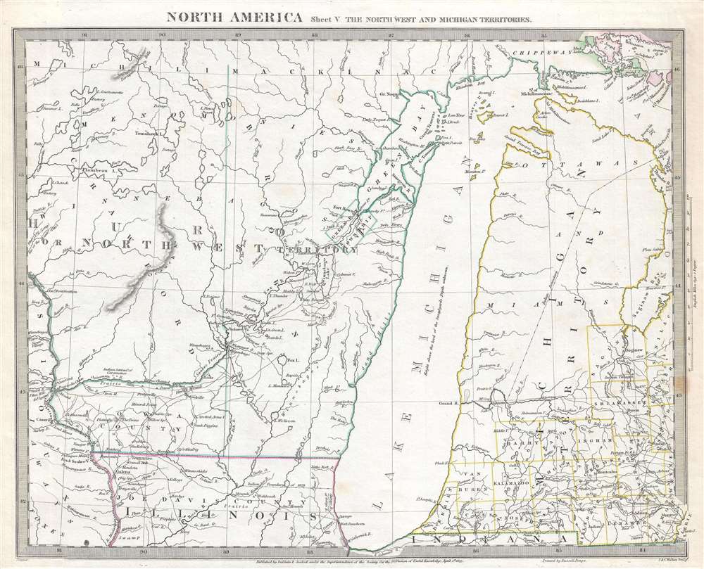
North America Sheet V The North West and Michigan Territories.
sold
- Digital Map Information
- Suitable for large format printing
- Full resolution TIFF file
- ICC color profile embedded
- Delivered instantly via download link
This is a scarce and important map issued by the Society for the Diffusion of Useful Knowledge, or S.D.U.K., in 1833, depicting Lake Michigan, the second largest of the five Great Lakes, and the only one that lies entirely within the United States. Centered on Lake Michigan, the map depicts the Huron or Northwest Territory (modern day Wisconsin) and the Michigan Territory (modern day Michigan) along with parts of northern Illinois. Territories and counties are identified using outline color. Lake Michigan is slightly malformed and distended on the vertical axis. Several Indian tribes are noted, including the Ottawa and the Chippeway. The Bad Axe River where the Bad Axe Massacre or the Battle of Bad Axe was fought at the end of the Black Hawk War in 1832, a year before this map was issued, is also labeled. (more details)
A detailed map of coastal North Carolina, South Carolina, and Georgia.
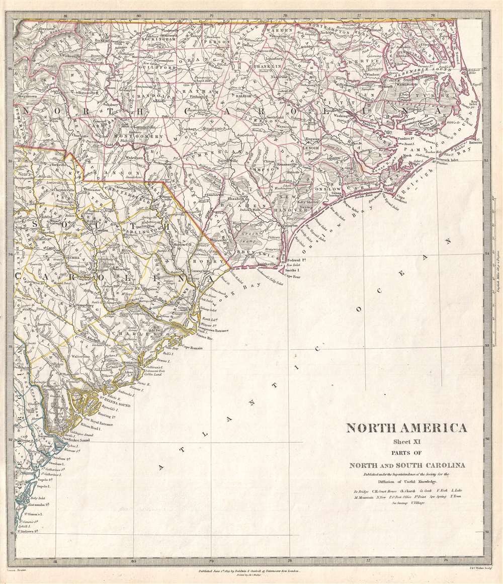
North America Sheet XI Parts of North and South Carolina.
sold
- Digital Map Information
- Suitable for large format printing
- Full resolution TIFF file
- ICC color profile embedded
- Delivered instantly via download link
This is an 1833 Society for the Diffusion of Useful Knowledge (S.D.U.K.) map of North Carolina and South Carolina. The map depicts North and South Carolina from Morgantown, North Carolina, Newberry, South Carolina, and Springfield, Georgia, to the Atlantic Ocean. ... (more details)
Beautiful map featuring Lake Superior, the largest of the Great Lakes of North America.

North America Sheet IV Lake Superior.
sold
- Digital Map Information
- Suitable for large format printing
- Full resolution TIFF file
- ICC color profile embedded
- Delivered instantly via download link
This is an 1832 Society for the Diffusion of Useful Knowledge (S.D.U.K.) map of Lake Superior, the largest of the five Great Lakes. Centered on Lake Superior, the map depicts the modern-day regions of southern Ontario, northern Michigan and northeastern ... (more details)
A stunning map of an ancient city with a long history.
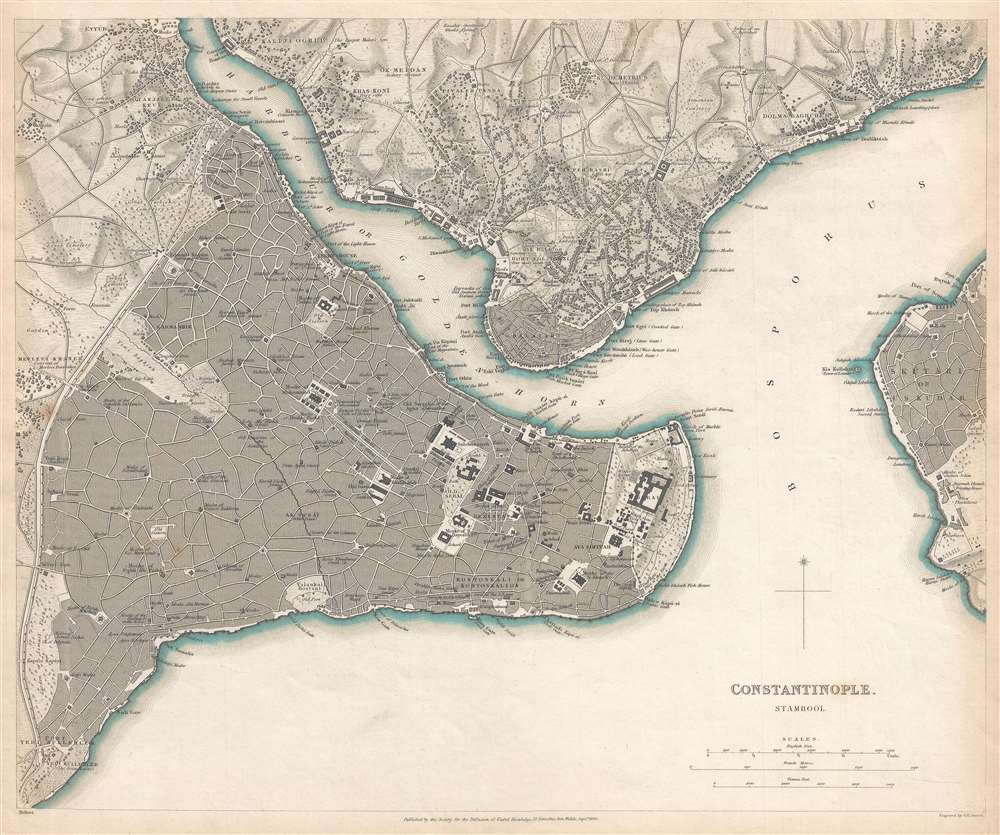
Constantinople. Stambool.
sold
- Digital Map Information
- Suitable for large format printing
- DPI: 300
- File Size: 7.13 MB
- File Type: ZIP / TIFF
- ICC color profile embedded
- Delivered instantly via download link
This is an 1840 Society for the Diffusion of Useful Knowledge (S.D.U.K.) city map or plan of Constantinople, today known as Istanbul. Once known as Byzantium, the city was renamed Constantinople after Emperor Constantine the Great. It soon became the ... (more details)
Features a view of Saint Basil's Cathedral.

Moscow. (москвы.)
sold
- Digital Map Information
- Suitable for large format printing
- DPI: 300
- File Size: 6.39 MB
- File Type: ZIP / TIFF
- ICC color profile embedded
- Delivered instantly via download link
This is an 1836 Society for the Diffusion of Useful Knowledge (S.D.U.K.) city map or plan of Moscow, Russia. The map depicts the city from the Vogankovskaia Novaia Zastava (one of the gates in the city walls) to the Lake of Khapilovkoi and from St. ... (more details)
One of the rarest and most decorative mid-19th century French maps of the United States.
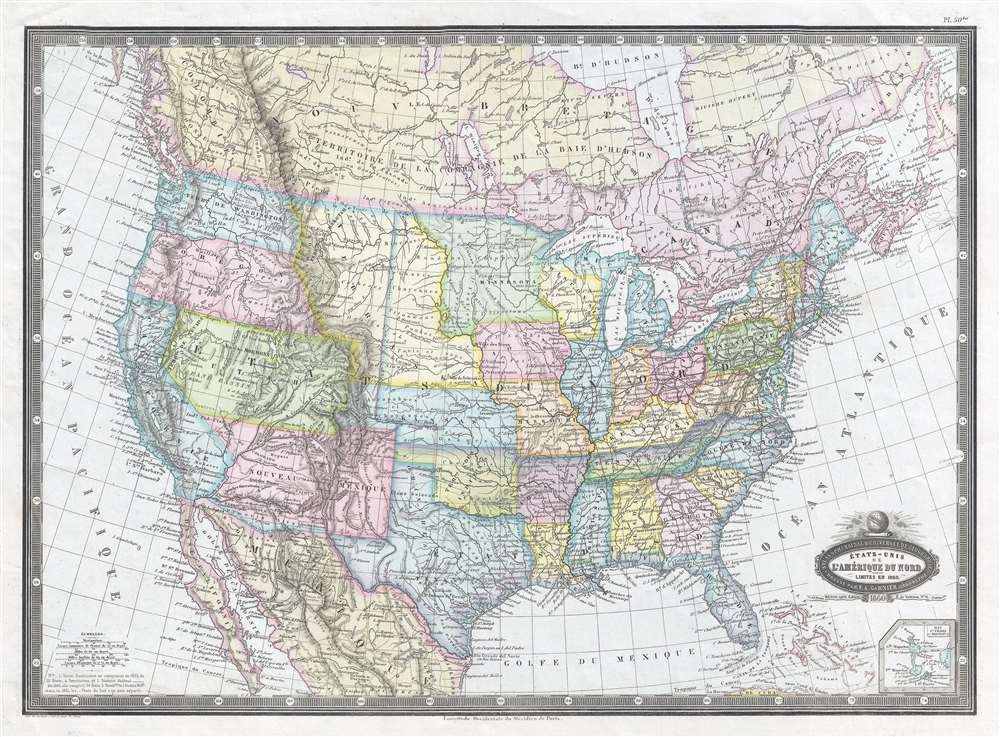
États-Unis de l'Amérique du Nord. Limites en 1860.
sold
- Digital Map Information
- Suitable for large format printing
- File Size: 8.76 MB
- File Type: ZIP / TIFF
- ICC color profile embedded
- Delivered instantly via download link
This is a strikingly beautiful 1860 F. A. Garnier map of the United States and depicts the U.S. from the Pacific Ocean to the Atlantic Ocean and from Canada to Mexico. Beautifully colored, this map displays several aspects of classic American ... (more details)
A beautiful map of the North Atlantic.
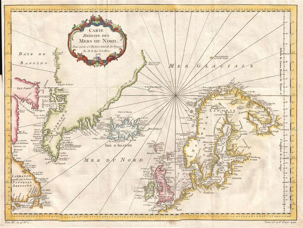
Carte Reduite des Mers du Nord.
sold
- Digital Map Information
- Suitable for large format printing
- Full resolution TIFF file
- ICC color profile embedded
- Delivered instantly via download link
This is a 1758 Jacques-Nicolas Bellin map of the North Pacific, including Greenland, Iceland, and Scandinavia. The map depicts the region from Labrador to Scandinavia and from the Arctic Ocean to northern Europe. Beautifully engraved and ... (more details)
Extraordinary early manuscript map of Shanghai, China.

[Shanghai, China]
sold
- Digital Map Information
- Suitable for large format printing
- File Size: 12.79 MB
- File Type: ZIP / TIFF
- ICC color profile embedded
- Delivered instantly via download link
This is an outstanding map of great significance, an 1874 (Tongzhi 13) manuscript version of the 1873 Shinagawa Tadamichi Map of Qing Shanghai, China. This large format map covers Qing Shanghai's old foreign district. From the conflux of the Huangpu River and the Wusong River, the map extends westward to, roughly, the modern day Xisang Middle Road, south to, roughly, Fangbang Middle Road, and eastward along the Huangpu River to the Dalian Road Tunnel. Houses appear in red, roads are yellow, rivers are green, and open land is uncolored. (more details)
Manuscript map of Hong Kong - possibly first Japanese map of Hong Kong.
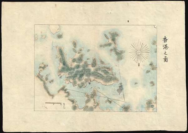
香港之圖 / Map of Hong Kong
sold
- Digital Map Information
- Suitable for large format printing
- File Size: 3.36 MB
- File Type: ZIP / TIFF
- ICC color profile embedded
- Delivered instantly via download link
A finely executed early Japanese manuscript map of Hong Kong and some of the surrounding islands prepared around 1874 - likely the earliest Japanese map to focus specifically on Hong Kong. Oriented to the south, the map covers all of Hong Kong Island, Kowloon, and some of the surrounding lands. The map includes no development, suggesting the source must be the 1841 first edition of Sir. Edward Belcher's historic plan, which it also matches in scope of coverage. (more details)
An beautiful and historic map of the region surrounding Shanghai and the Yangtze River.
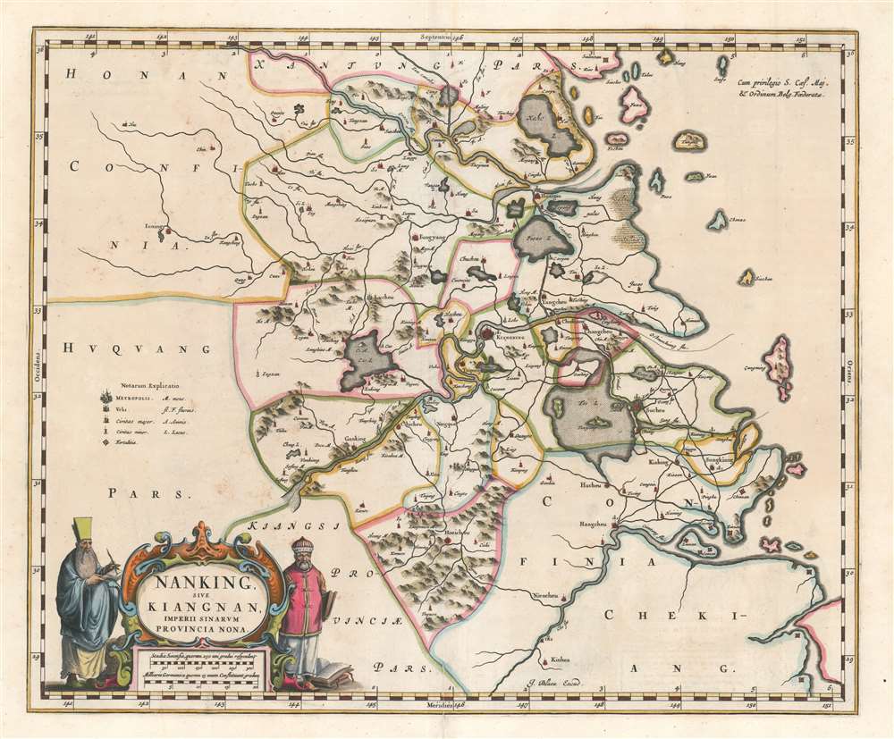
Nanking Sive Kiangnan, Imperii Sinarum Provincia Nona.
sold
- Digital Map Information
- Suitable for large format printing
- DPI: 600
- File Size: 24.16 MB
- File Type: ZIP / TIFF
- ICC color profile embedded
- Delivered instantly via download link
This is a 1662 Martino Martini and Joan Blaeu map of Jiangsu Province and Shanghai Municipality in China. The map depicts the environs of the lower Yangtze River from west of Nanjing (Kiangning) to the East China Sea. Numerous cities and ... (more details)
Map showing Korea as an Island!
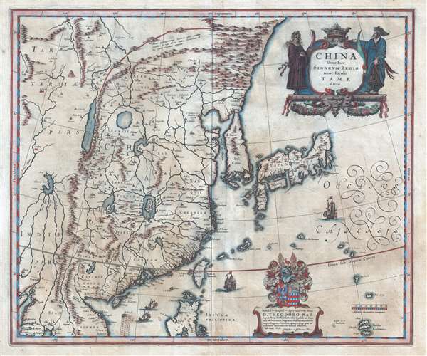
China Veteribus Sinarum Regio nunc Incolis Tame dict.
sold
- Digital Map Information
- Suitable for large format printing
- Full resolution TIFF file
- ICC color profile embedded
- Delivered instantly via download link
An important c. 1636 map of China, Korea, and Japan by Willem and Johannes Blaeu. The map covers East Asia from Lake Chiamay (apocryphal) to Japan and from Mongolia to the Philippines. Blaeu’s map represents the most complete illustration of China and East Asia in general available at the time. (more details)
Rare view of Sydney Harbour following the reconstruciton of 1900 - 1913.

Birds Eye View of General Wharfage Scheme West of Dawes Point as it will appear when completed.
sold
- Digital Map Information
- Suitable for large format printing
- File Size: 17.02 MB
- File Type: ZIP / TIFF
- ICC color profile embedded
- Delivered instantly via download link
A scarce 1913 William Hardy Wilson chromolithographic view of Sydney Harbor, Australia. The view looks southward from somewhere high above Goat Island. Dawes Point, Barangaroo, and the Central business district appear on the left, Pyrmont is center, and Balmain is on the right. The focus of the view are Sydney's large harbors, Darling Harbour, Backwattle Bay, Rozelle Bay, White Bay, and Johnstons Bay. It illustrates proposed subaqueous tunnels and is illustrated with numerous cargo ships throughout. (more details)
A wonderful map tracing the proposed route of the Lincoln Highway from New York to San Francisco.

One Hundred Fifty Thousand Miles of National Highways Proposed by the National Highways Association Washington, D.C. with the Alignment of the Lincoln Highway (Tentative Location - Subject to Revision) Showing Every City, Town, Village, and Hamlet Throughout its Entire Length.
sold
- Digital Map Information
- Suitable for large format printing
- File Size: 13.41 MB
- File Type: ZIP / TIFF
- ICC color profile embedded
- Delivered instantly via download link
This is a 1923 National Highways Association map of the United States. Highlighting the proposed route of the Lincoln Highway from New York to San Francisco, the map depicts a portion of the continental United States from the Pacific Ocean to the Atlantic Ocean and from Montana, South Dakota, Minnesota, and New England south to the central United States. Created as a promotional piece for the Lincoln Highway, and more generally for the 'one hundred fifty thousand miles of national highways proposed by the National Highways Association. With the central focus placed on the Lincoln Highway, every city, town, and village along the proposed highway would pass is marked by a white dot and labeled. The rest of the highway network snakes its way across this slice of the country, with cities and large towns meriting a label as well. National parks are noted throughout the country by a shade of purple, while the bright yellow sections are Indian reservations. The green scattered about the American West represent national forests. A profile view of the changes in elevation experienced along the route of the Lincoln Highway is situated along the bottom and includes the names of hotels, garages, and the distance in miles either from San Francisco or miles from New York. (more details)
French map issued in the fourth year of the French and Indian War.
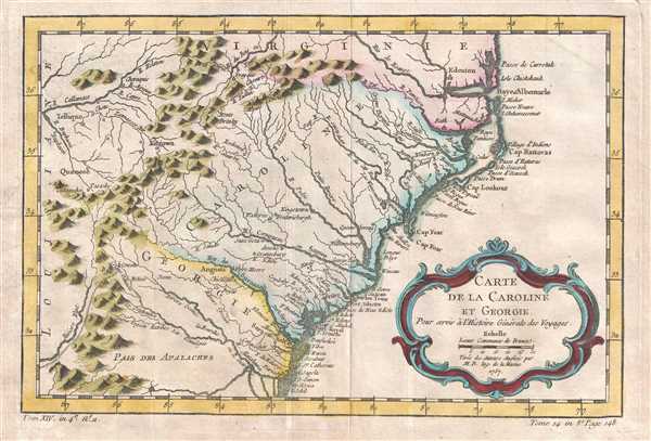
Carte de la Caroline et Georgie.
sold
- Digital Map Information
- Suitable for large format printing
- DPI: 300
- File Size: 2.35 MB
- File Type: ZIP / TIFF
- ICC color profile embedded
- Delivered instantly via download link
This is French cartographer Jacques-Nicolas Bellin’s 1757 map of the Carolinas and Georgia. It depicts modern day North Carolina, South Carolina, and Georgia, along with parts of Virginia and eastern Tennessee, extending from just ... (more details)
Important map of the Chesapeake Bay and environs.
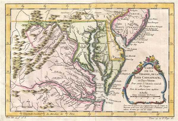
Carte de la Baye de Chesapeack et Pays Voisins.
sold
- Digital Map Information
- Suitable for large format printing
- DPI: 300
- File Size: 2.49 MB
- File Type: ZIP / TIFF
- ICC color profile embedded
- Delivered instantly via download link
This is a beautiful 1757 Jacques-Nicolas Bellin map of the Chesapeake Bay and its environs, including Virginia, Maryland, and Delaware, and parts of New Jersey and Pennsylvania. The map depicts from the Susquehanna River and ... (more details)
A map, tourist guide, and letter accompanied by its original mailer, sent home by a naval aviator from Pensacola.
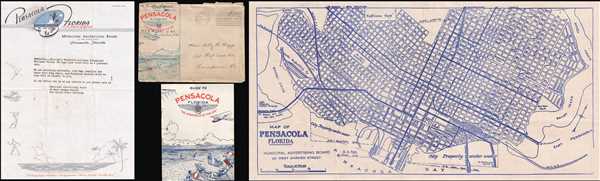
Map of Pensacola Florida.
sold
- Digital Map Information
- Suitable for large format printing
- File Size: 9.34 MB
- File Type: ZIP / TIFF
- ICC color profile embedded
- Delivered instantly via download link
This is a 1944 Municipal Advertising Board city map or plan of Pensacola, Florida. The map depicts downtown Pensacola from Bayou-Chico to Bayou Texar and from Kupfrians Park to Pensacola Bay. Highly detailed, all the city's ... (more details)
Map of New England during the French and Indian War.
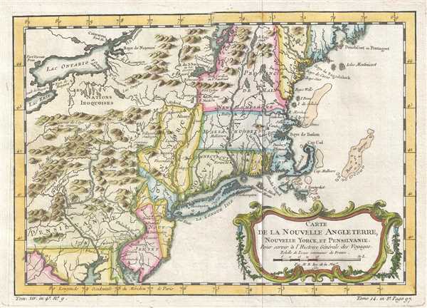
Carte de la Nouvelle Angleterre Nouvelle Yorck et Pensilvanie.
sold
- Digital Map Information
- Suitable for large format printing
- DPI: 300
- File Size: 2.84 MB
- File Type: ZIP / TIFF
- ICC color profile embedded
- Delivered instantly via download link
This is a Jacques-Nicolas Bellin map of New England. The map depicts the region from Lake Erie to the Atlantic Ocean and from Lake Champlain to the extreme northern portion of the Chesapeake Bay, including some or all of the states of New York, Massachusetts, Pennsylvania, New Jersey, Connecticut, Rhode Island, Vermont, New Hampshire, and Maine. Numerous cities and towns are labeled throughout, including New York, Boston, Cambridge, Philadelphia, New Haven, and Salem. American Indian tribes and settlements are also identified, including the Five Iroquois Nations, while others are referred to simply as villages sauvages. Several rivers, lakes, and mountain ranges are also illustrated. (more details)
Illustrates the Ptolemaic and Copernican models of the solar system and the Earth and the constellations.

Sphere de Copernic. Sphere de Ptolemée. Globe Terrestre. Globe Celeste.
sold
- Digital Map Information
- Suitable for large format printing
- DPI: 300
- File Size: 4.68 MB
- File Type: ZIP / TIFF
- ICC color profile embedded
- Delivered instantly via download link
This is a 1763 Jean Janvier chart of four celestial spheres or globes. Each of the four instruments present a different astronomical phenomenon. The first, on the far left, illustrates the Copernican model of the solar ... (more details)
Enormous map of China identifying roads and bridges. Shows early Chinese claim to Senkaku / Diaoyu Islands .
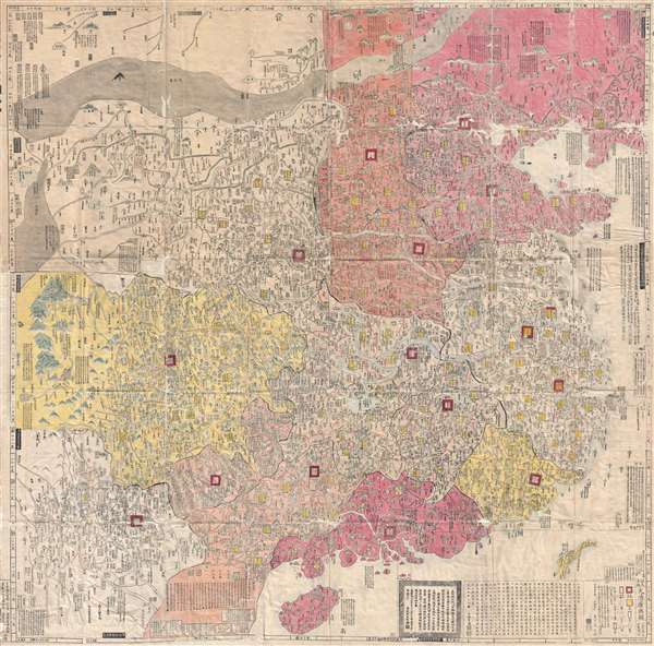
大淸廣輿圖 : 經天合地 : 境域 / Dai Shin kōyozu : keiten gōchi : nikyō jūshishō shii kyōiki. / Enlarged Terrestrial Map of the Great Qing: The Two Capitals, 14 Provinces, and 4 Provinces.
sold
- Digital Map Information
- Suitable for large format printing
- Full resolution TIFF file
- ICC color profile embedded
- Delivered instantly via download link
A rare and important Tenmei 5, Qianlong 50 or 1785 woodblock map of Qing Dynasty China printed in woodblock. This enormous Chinese language map covers from the Tibet and the Kunlun Mountains in western China to Taiwan ... (more details)
Important colonial period map of the American Southeast - with seashell and coral cartouche!
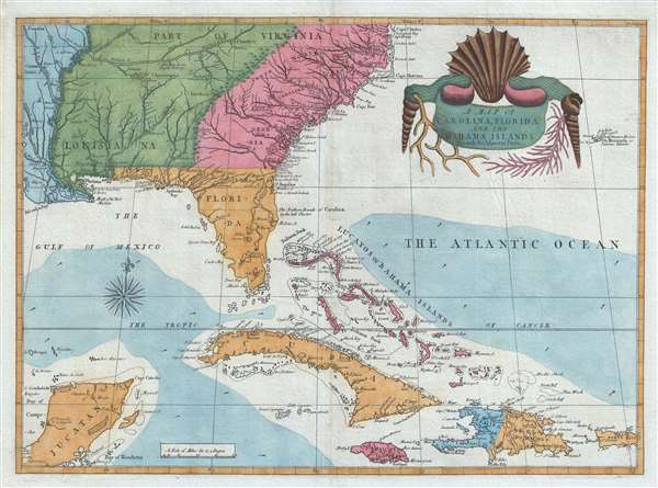
A Map of Carolina, Florida and the Bahama Islands with the Adjacent Parts.
sold
- Digital Map Information
- Suitable for large format printing
- DPI: 300
- File Size: 9.49 MB
- File Type: ZIP / TIFF
- ICC color profile embedded
- Delivered instantly via download link
A fine example of Mark Catesby’s rare 1743 / 1771 map of the southeastern parts of North America. This map is considered one of the finest maps of the colonial era American southeast. The map covers from the Mississippi River and from Cape Charles and Cape Henry to Jamaica, including all of North Carolina, South Carolina, Georgia, Florida, Louisiana, Cuba, Hispaniola, the Bahamas, Porto Rico, and parts of the Yucatan. Among other features, the map is notable for its remarkable cartouche design, which includes shells, corals, and seaweeds indigenous to the Americas. The map is furthermore an important reference for early forts, Indian tribes, English factories, and more in the southeast. The river systems of Georgia and Carolina are particularly impressive in their detail. (more details)