
Coast Survey chart of Florida's Cedar Keys following the Seminole Wars.

Sketch F. No. 4 Reconnoissance of Vicinity of Cedar Keys Coast of Florida.
sold
- Digital Map Information
- Suitable for large format printing
- DPI: 300
- File Size: 1.52 MB
- File Type: ZIP / TIFF
- ICC color profile embedded
- Delivered instantly via download link
This is an important 1851 U.S. Coast Survey mapping of Cedar Keys and vicinity, Florida. The map depicts from Suwannee Bay south to St. Martin’s Keys and includes numerous depth soundings, coastal features, and several triangulation points. The chart also ... (more details)
Chart noting the proposed site of the Point Conception Light on the southwestern coast near Santa Barbara, California.
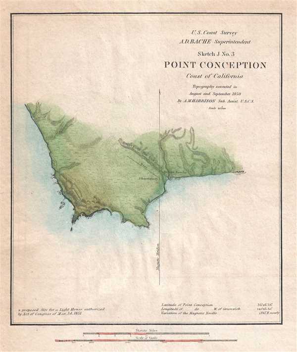
Sketch J No. 3 Point Conception Coast of California.
sold
- Digital Map Information
- Suitable for large format printing
- DPI: 300
- File Size: 1.43 MB
- File Type: ZIP / TIFF
- ICC color profile embedded
- Delivered instantly via download link
This is an 1851 U.S. Coast Survey chart or map of Point Conception on the California Coast, where the Santa Barbara Channel meets the Pacific Ocean. The map is beautifully detailed and illustrates some inland features, including the Valley of the Cove and ... (more details)
Nautical sketch depicting progress of Coast Survey near Savannah.

Sketch E. No. 2 Shewing the progress of the Survey in the vicinity of Savannah Georgia.
sold
- Digital Map Information
- Suitable for large format printing
- DPI: 300
- File Size: 0.92 MB
- File Type: ZIP / TIFF
- ICC color profile embedded
- Delivered instantly via download link
This is an 1851 U.S. Coast Survey triangulation chart or map of Savannah, Georgia and the Savannah River. The chart depicts the progress of the survey work in this area by date annotated sections. Navigation markers such as Fort Jackson, Tybee ... (more details)
Labels Pensacola and the Navy Yard.

Sketch G Showing the progress in Secion No. 7 U.S. Coast Survey in the year 1849 Reconnoissance of Pensacola and Perdido Baysand plan of Triangulation.
sold
- Digital Map Information
- Suitable for large format printing
- DPI: 300
- File Size: 0.9 MB
- File Type: ZIP / TIFF
- ICC color profile embedded
- Delivered instantly via download link
This is an 1849 U. S. Coast Survey triangulation chart or map of the Gulf Coast of Alabama and Florida. The map depicts the region from Bon Secour Bay, Alabama to East Bay, Florida. Illustrating the coast in detail, numerous locations throughout ... (more details)
Charming map of Grand Bay, Alabama and environs.

Sketch H. No. 7 Grand Bay Including the Entrance of Horn Island Pass.
sold
- Digital Map Information
- Suitable for large format printing
- DPI: 300
- File Size: 0.89 MB
- File Type: ZIP / TIFF
- ICC color profile embedded
- Delivered instantly via download link
This is an 1851 U. S. Coast Survey nautical chart or map of Grand Bay, Alabama and the Mississippi. Divided in half by the Alabama-Mississippi state line, this map depicts both parts of both states from Pascagoula, Mississippi to Point Aux Pins ... (more details)
Rare Broadside Map chronicling the last resurgence in piracy in the West Indies.

Map of the West Indies, and the History of Piracies Committed on American Seamen and Commerce. / To the Gallant Officers and Seamen of the American Navy, the Protectors of our Commerce in the West India Seas this Map Is Respectfully Inscribed by the Publishers. / West Indies, from the latest and best authorities.
sold
- Digital Map Information
- Suitable for large format printing
- DPI: 300
- File Size: 20.03 MB
- File Type: ZIP / TIFF
- ICC color profile embedded
- Delivered instantly via download link
A remarkable, separately issued, and extremely rare 1825 broadside map by Nathaniel and Simeon Smith Jocelyn of New Haven, Connecticut, responding to the last great outbreak of West Indian piracy between 1817 and 1825. It responds with ... (more details)
Attractive U.S. Coast Survey report maps of the Chesapeake Bay.

Sketch C Showing the Progress of the Survey in Section No. III From 1843 to 1851.
sold
- Digital Map Information
- Suitable for large format printing
- DPI: 300
- File Size: 12.6 MB
- File Type: ZIP / TIFF
- ICC color profile embedded
- Delivered instantly via download link
This is an exceptional example of the 1851 U.S. Coast Survey's progress chart of the Chesapeake Bay. The map covers from the mouth of the Susquehanna River southwards as far as Cape Henry and Norfolk. This chart includes both the ... (more details)
Rare Chinese-Jesuit imprint thematic map illustrating Catholic Missionary activity in Shanghai.

Shanghai Catholique.
sold
- Digital Map Information
- Suitable for large format printing
- File Size: 10.59 MB
- File Type: ZIP / TIFF
- ICC color profile embedded
- Delivered instantly via download link
This is an extremely rare 1933 map of Catholic Missions in Shanghai. The map was published in Shanghai by the T'ou-sè-wè Orphanage Press, a Jesuit printing press run as part of a vocational school / orphanage situated just ... (more details)
Qing mapping of Taiwan's Aboriginal communities - Kaishan Fufan!

臺灣番地圖 / Táiwān fān dìtú / 台灣番地圖 / Map of Taiwan’s Aboriginal Tribes.
sold
- Digital Map Information
- Suitable for large format printing
- File Size: 14.42 MB
- File Type: ZIP / TIFF
- ICC color profile embedded
- Delivered instantly via download link
A discovery of considerable interest to Taiwan / Formosa enthusiasts, this 1887 / 1896 thematic map of Taiwan aboriginal population and tribes. It was drawn under the Qing as part of the Kaishan Fufan (開山撫番) policy ... (more details)
The most important and influential map of Virginia and Carolina to appear in the 17th century.

Virginiae Item et Floridae Americae Provinciarum, nova Descriptio.
sold
- Digital Map Information
- Suitable for large format printing
- DPI: 300
- File Size: 7.92 MB
- File Type: ZIP / TIFF
- ICC color profile embedded
- Delivered instantly via download link
Published in 1606 by the Mercator/Hondius firm, this is the most influential map of the southeastern part of North America to emerge in the 17th century and the first map to depict Virginia and Florida. Entitled, Virginiae ... (more details)
California as an Island and the apocryphal inland rivers of Lahontan.

A Map of North America With the European Settlements and whatever else is remarkable in ye West Indies from the latest and best Observations.
sold
- Digital Map Information
- Suitable for large format printing
- DPI: 300
- File Size: 9.77 MB
- File Type: ZIP / TIFF
- ICC color profile embedded
- Delivered instantly via download link
An uncommon 1745 map of North America with California as an island by Richard W. Seale. The map offers much of interest, including a fascinating mapping of sources of the Mississippi River, California as an island, and the apocryphal geography of the Baron Lahontan. It covers all of North America from Atlantic to Pacific and from Baffin Bay to the Spanish Main, inclusive of Central America and the West Indies. Oceanic depths, winds, and currents are illustrated via stippling, shading, annotation, and arrows. A rococo title cartouche appears at right center. (more details)
An charming map of the city which hosts the Rock and Roll Hall of Fame.

Map of the City of Cleveland and Suburbs Showing Location and Distance from the Public Square of All Streets.
sold
- Digital Map Information
- Suitable for large format printing
- File Size: 14.59 MB
- File Type: ZIP / TIFF
- ICC color profile embedded
- Delivered instantly via download link
This is an 1882 J. S. Morse city map or plan of Cleveland, Ohio. Situated on the shores of Lake Erie, this map radiates out from the city center 5.5 miles. Myriad streets are labeled, along with the harbor and canal. The ... (more details)
Depicts the possible bombardment of England by the Nazis - before the May 1940 invasion of Western Europe.
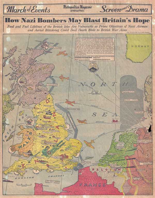
How Nazi Bombers May Blast Britain's Hope.
sold
- Digital Map Information
- Suitable for large format printing
- File Size: 12.74 MB
- File Type: ZIP / TIFF
- ICC color profile embedded
- Delivered instantly via download link
This is a 1940 Detroit News Metropolitan Magazine pictorial map of England, Scotland, Wales, and the northern coast of Europe. The map depicts the region from Belfast, Ireland to Norway and from the Orkney Islands to ... (more details)
Illustrates the Berlin Wall less than 18 months after it was built - a physical manifestation of the Cold War.
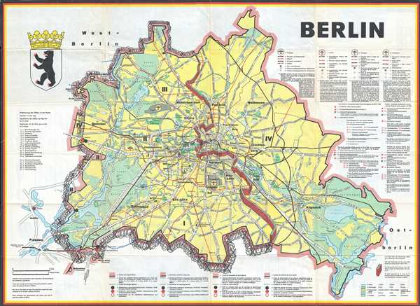
Berlin.
sold
- Digital Map Information
- Suitable for large format printing
- File Size: 16.26 MB
- File Type: ZIP / TIFF
- ICC color profile embedded
- Delivered instantly via download link
This is a 1962 JRO-Sonderkarte pictorial city map of Berlin, Germany. The map depicts East and West Berlin, with the recently constructed Berlin Wall dividing the city in two. Created within 18 months of the ... (more details)
Map promoting early American tourism to the 'Wild West.'
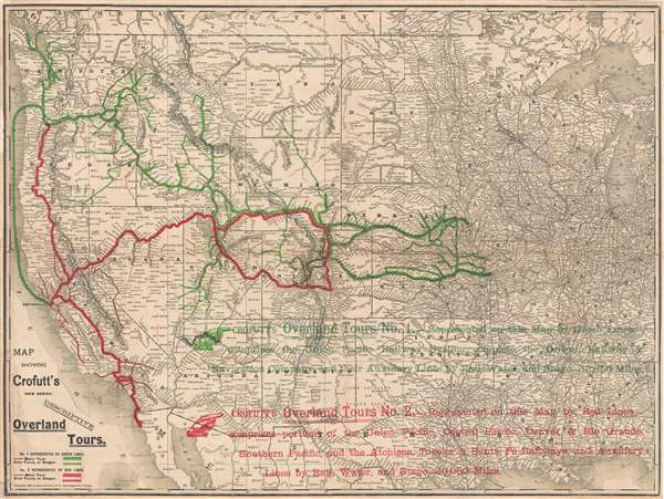
Map showing Crofutt's (new series) descriptive overland tours.
sold
- Digital Map Information
- Suitable for large format printing
- File Size: 11.31 MB
- File Type: ZIP / TIFF
- ICC color profile embedded
- Delivered instantly via download link
This uncommon 1888 map illustrates proposed tours of the American west as described in Crofutt's Overland Tours . The map covers roughly from the Pacific Ocean to Lake Michigan, and all of the states ... (more details)
Rare map of Florida illustrating shipping and railroad lines.
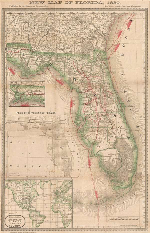
New Map of Florida, 1880.
sold
- Digital Map Information
- Suitable for large format printing
- File Size: 6.42 MB
- File Type: ZIP / TIFF
- ICC color profile embedded
- Delivered instantly via download link
This is an unusual and rare 1881 map of Florida issued by the Bureau of Immigration and Rand McNally. The map covers all of Florida as well as the Florida Keys and adjacent parts of Georgia as far ... (more details)
Beautiful English map of Southern Italy.
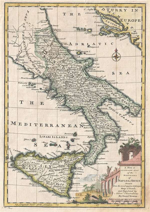
A New and Accurate Map of the Kingdoms of Naples and Sicily.
sold
- Digital Map Information
- Suitable for large format printing
- Full resolution TIFF file
- ICC color profile embedded
- Delivered instantly via download link
An attractive 1747 map of southern Italy by the British cartographer Emanuel Bowen. The map covers the Kingdoms of Naples and Sicily, including part of the Papal States, noting important towns, ... (more details)
Includes the Lofoten Maelstrom!
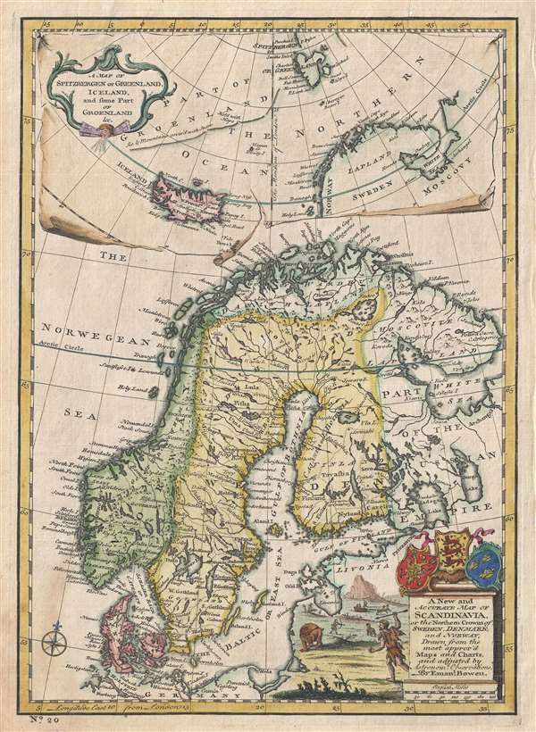
A New and Accurate Map of Scandinavia or the Northern Crowns of Sweden, Denmark and Norway. A Map of Spitzbergen or Greenland, Iceland and some part of Groenland etc.
sold
- Digital Map Information
- Suitable for large format printing
- Full resolution TIFF file
- ICC color profile embedded
- Delivered instantly via download link
This is a fascinating 1747 map of Scandinavia by the British cartographer Emanuel Bowen. It covers Denmark, Norway, Sweden, Finland (shown as part of Sweden) and parts of the Russian Empire. ... (more details)
Includes the Lofoten Maelstrom!
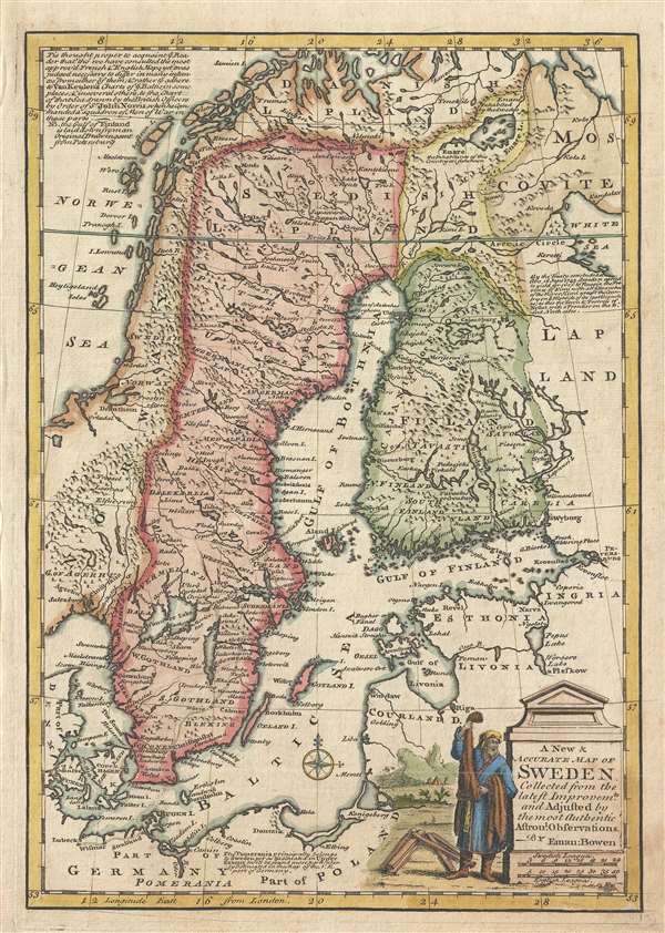
A New and Accurate Map of Sweden.
sold
- Digital Map Information
- Suitable for large format printing
- Full resolution TIFF file
- ICC color profile embedded
- Delivered instantly via download link
This is an attractive 1747 map of Sweden by the Welsh cartographer Emanuel Bowen. It covers Sweden and Finland (shown as part of Sweden) as well as parts of modern day Estonia, Latvia, ... (more details)
Exceptional complete example of the First American Road Atlas!
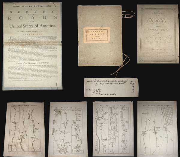
A Survey of Roads of the United States of America by Christopher Colles.
sold
A superb example, entirely complete, of Christopher Colles' 1789 - 1790 A Survey of the Roads of the United States of America. This is the First American Road atlas, wherein at least some of the plates represent the first American maps engraved by a female - Colles' 13-year-old daughter Eliza. Covering depictions from Albany, New York to Williamsburg, Virginia, Colles' atlas consists of a prospectus, a title page, and 83 separate strip maps, each covering some 12 miles of roads and offering invaluable detail about the natural and human landscape of late 18th-century America, and was published in commemoration of the founding of the new republic in 1789. (more details)