
Attractive detailed map of New England featuring the region's railroad network.
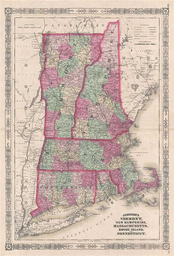
Johnson's Vermont, New Hampshire, Massachusetts, Rhode Island, and Connecticut.
sold
- Digital Map Information
- Suitable for large format printing
- File Size: 11.29 MB
- File Type: ZIP / TIFF
- ICC color profile embedded
- Delivered instantly via download link
This is an 1864 Alvin Jewett Johnson map of New England. The map depicts the New England from Long Island to Maine and from the Hudson Valley to the Atlantic Seaboard. Numerous cities, towns, and townships are labeled, along with counties. Several railroads are ... (more details)
Charming map of New York City before consolidation - labels individual residences throughout Brooklyn, Queens, and New Jersey.

Sidney's Map of Twelve Miles Around New York.
sold
- Digital Map Information
- Suitable for large format printing
- DPI: 300
- File Size: 36.11 MB
- File Type: ZIP / TIFF
- ICC color profile embedded
- Delivered instantly via download link
This is an 1849 James Charles Sidney map of New York City and the surrounding area. The map depicts the region from New Jersey to Westchester, Flushing, and Jamaica, and from Bergen, New Jersey and Inwood in Manhattan to Staten Island and New York Bay. Highly ... (more details)
Illustrates the vast amounts of land available for purchase from the Northern Pacific Railroad.
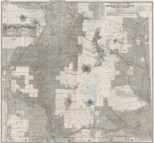
Map Showing Land Grant of the Northern Pacific Railroad Co. in Western Washington and Northern Oregon.
sold
- Digital Map Information
- Suitable for large format printing
- File Size: 37.83 MB
- File Type: ZIP / TIFF
- ICC color profile embedded
- Delivered instantly via download link
This is an 1890 Matthews. Northrop, and Company Northern Pacific Railroad map of western Washington state and northern Oregon. The map depicts the region from the Pacific Ocean to the Columbia River and from the Strait of Juan de Fuca to the Portland. Nearly ... (more details)
Brightly colored and highly detailed pictorial map of mammals and birds native to the United States.

Pictorial Wildlife and Game Map of the United States.
sold
- Digital Map Information
- Suitable for large format printing
- File Size: 18.48 MB
- File Type: ZIP / TIFF
- ICC color profile embedded
- Delivered instantly via download link
This is a 1956 Ira Moss pictorial map of wildlife and game native to the United States. The map depicts the region from Canada to Mexico and from the Pacific Ocean to the Atlantic Ocean. Bright, colorful, and highly detailed, fifty-five different mammal ... (more details)
Important map of the British Colonies in North America at the outset of the American Revolutionary War.
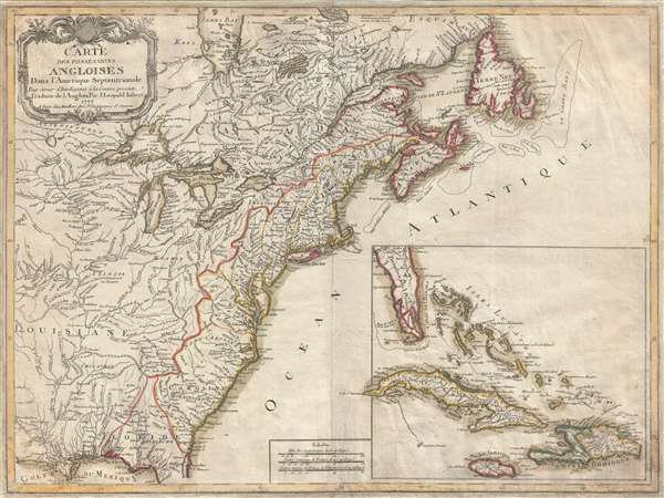
Carte des Possessions Angloises Dans L'Amerique Septentrional Pour Servir d'Intelligence á la Guerre presente Traduite de L'Anglois Par J. Leopold Imbert.
sold
- Digital Map Information
- Suitable for large format printing
- DPI: 300
- File Size: 15.9 MB
- File Type: ZIP / TIFF
- ICC color profile embedded
- Delivered instantly via download link
This is the rare 1777 separate issue, old color, first edition of J. Leopold Imbert's important map illustrating the theater of the American Revolutionary War (1775 - 1783). In addition to being a significant map in its own right, this Imbert map ... (more details)
Guide map for transcontinental emigrant travel in the antebellum period.

A New Map of the United States of America.
sold
- Digital Map Information
- Suitable for large format printing
- File Size: 16.94 MB
- File Type: ZIP / TIFF
- ICC color profile embedded
- Delivered instantly via download link
An unusual example of Charles Desilver's 1856 pocket map of the United States. The map covers the United States from coast to coast during the post-Mexican American War / pre-Civil War Period - a era of incredible national optimism, Indian Wars, ... (more details)
Gorgeous map celebrating college football - an American past time.

Albert Richard Football Map.
sold
- Digital Map Information
- Suitable for large format printing
- File Size: 17.12 MB
- File Type: ZIP / TIFF
- ICC color profile embedded
- Delivered instantly via download link
This is a 1940 F. E. Cheeseman and Albert Richard football map of the United States. The map depicts the continental United States from the Pacific Ocean to the Atlantic Ocean and from Canada to Mexico. Pennants from universities and colleges ... (more details)
Rare map of Manhattan based on Viele showing c. 1606 American Indian settlements.
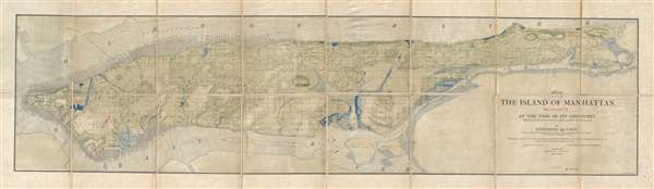
1609 The Island of Manhattan (Mannahtin) At the Time of its Discovery Showing its Elevations, Water-Courses, and Shore Line.
sold
- Digital Map Information
- Suitable for large format printing
- File Size: 25.84 MB
- File Type: ZIP / TIFF
- ICC color profile embedded
- Delivered instantly via download link
A very rare map of the island of Manhattan, New York City, as is presumably appeared in 1609, shortly after the Dutch began settling the island. This map was issued by Townsend MacCoun and is base, cartographically, on the great 1867 survey ... (more details)
Provides a visually enthralling overview of the beginning of World War II in Southeast Asia.
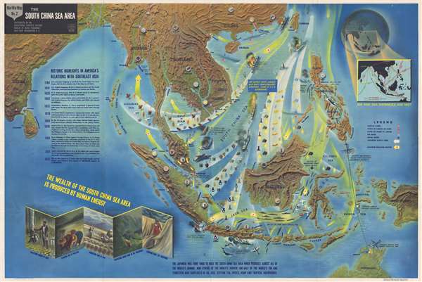
NavWarMap No. 2 The South China Sea Area.
sold
- Digital Map Information
- Suitable for large format printing
- File Size: 88.6 MB
- File Type: ZIP / TIFF
- ICC color profile embedded
- Delivered instantly via download link
This is a 1944 Navy Department pictorial map of Southeast Asia. The map depicts the region from India to the Pacific Ocean and from China to Java, New Guinea and northern Australia. Beautifully colored and incredibly detailed, this NavWarMap ... (more details)
Illustrates the Battle of the Atlantic and Allied strategic bombing campaigns in northwestern Europe.
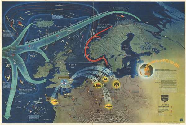
NavWarMap No. 3 World War 2 in the North Sea Area.
sold
- Digital Map Information
- Suitable for large format printing
- File Size: 82.2 MB
- File Type: ZIP / TIFF
- ICC color profile embedded
- Delivered instantly via download link
This is a 1944 Navy Department pictorial map of northwestern Europe and the North Atlantic. The map depicts the region from the Atlantic Ocean to Russia and from the Arctic Ocean to central France and Switzerland. Illustrating two crucial ... (more details)
Rare map of Bermuda promoting steamship travel.

Map of Bermuda Islands compiled for The Bermuda-Atlantic S. S. Co.
sold
- Digital Map Information
- Suitable for large format printing
- File Size: 7.01 MB
- File Type: ZIP / TIFF
- ICC color profile embedded
- Delivered instantly via download link
An extremely rare and previously unknown c. 1902 map of Bermuda issued to promote the Bermuda-Atlantic Steamship Company. The map covers all of Bermuda and some of the surrounding reefs. Shows roadways, shipping channels, streets, and ... (more details)
Beautiful world map with several vignettes.
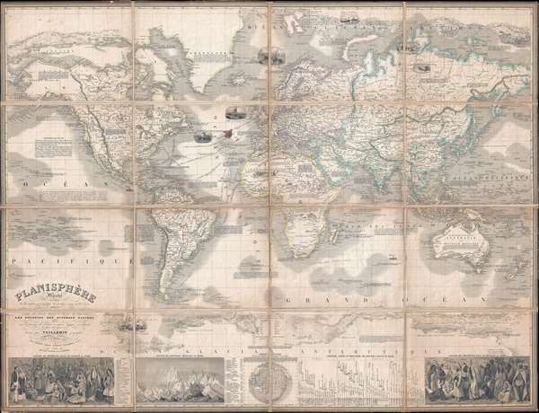
Planisphère Illustré présentant la description géographique des parties connues de la Terre indiquant l'époque des grandes decouverteset le nom des navigateurs, les Coloniess des Diverses Nations ainsi que le percours des bateaux à vapeur, l'époque des départs, la durée du trajet, etc.
sold
- Digital Map Information
- Suitable for large format printing
- DPI: 300
- File Size: 42.41 MB
- File Type: ZIP / TIFF
- ICC color profile embedded
- Delivered instantly via download link
This is a rare and magnificent 1851 case map of the world on Mercator's projection by French cartographer Alexandre Vuillemin. The map depicts the world in extraordinary detail with numerous decorative embellishments and prolific ... (more details)
An essential map for Transmississippi and American Southwest collectors.
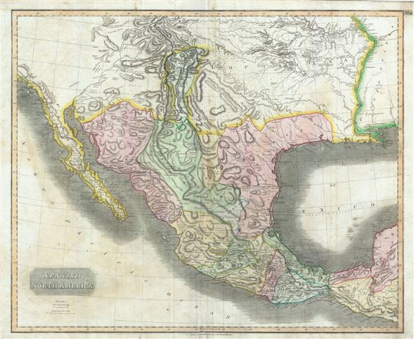
Spanish North America.
sold
- Digital Map Information
- Suitable for large format printing
- DPI: 300
- File Size: 23.42 MB
- File Type: ZIP / TIFF
- ICC color profile embedded
- Delivered instantly via download link
This beautiful 1814 map, along with Pinkerton's similar map, is most likely the most important large format English atlas map of the American Southwest to be produced in the 19th century. The map depicts Mexico from the Yucatan ... (more details)
Promotes the misguided belief that Algeria was a part of France.
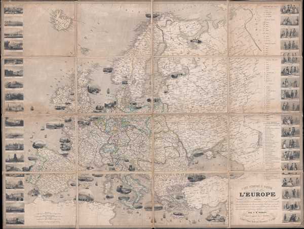
Carte Pittoresque et Maritime de l'Europe indiquant La division des Etats les Routes et Chemins de fer, la distance en kilometres de Paris à toutes les villes importantes, les Productions minerales, végétales et animales de chaque contrée, les Places fortes, les Ports militaires et marchands et l'itinéraire des bateaux à vapeur et paquebots.
sold
- Digital Map Information
- Suitable for large format printing
- DPI: 300
- File Size: 46.19 MB
- File Type: ZIP / TIFF
- ICC color profile embedded
- Delivered instantly via download link
This is an 1851 Alexandre Vuillemin and Aristide Michel Perrot folding map of Europe. The map depicts the region from the Atlantic Ocean to the Ural Mountains and from the Arctic Ocean to the Mediterranean Sea and North Africa. ... (more details)
Illustrates the elaborate international postal system at the end of the 19th century.
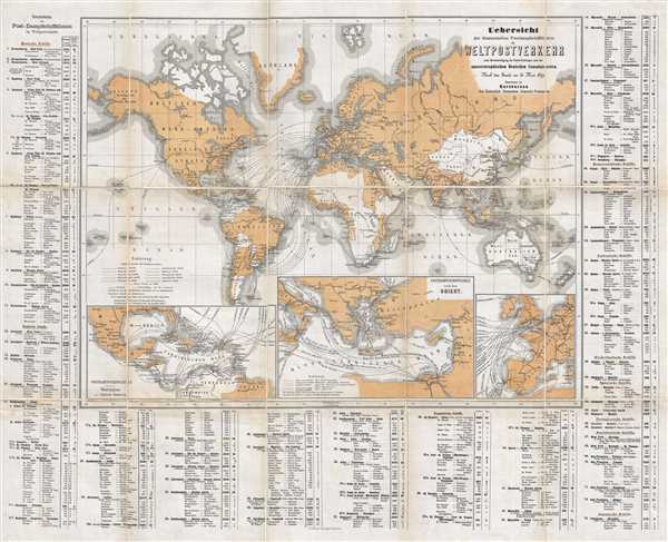
Uebersicht der überseeischen Postdampfschiffslinien im Weltpostverkehr unter Berücksichtigung der Postverbindungen nach den aussereuropäischen Deutschen Consulatsorten.
sold
- Digital Map Information
- Suitable for large format printing
- File Size: 21.22 MB
- File Type: ZIP / TIFF
- ICC color profile embedded
- Delivered instantly via download link
This is an 1879 Imperial German General Post Office map of world postal routes. The map depicts the world from Hawaii (the Sandwich Islands) to New Zealand and from the Arctic Ocean to Tierra del Fuego. Seventy-three different ... (more details)
Map of the Philippines most likely used around the time of the Spanish-American War.
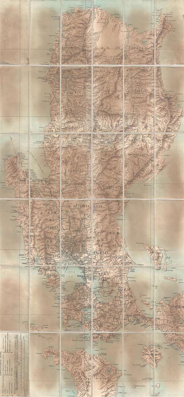
[Philippines].
sold
- Digital Map Information
- Suitable for large format printing
- Full resolution TIFF file
- ICC color profile embedded
- Delivered instantly via download link
This is a c. 1890 Spanish map of the Philippines. The map depicts the region from Pasaleng Bay, northern Luzon to Mindoro and from the South China Sea to the Philippine Sea. Highly detailed, numerous cities, towns, and ... (more details)
Includes a reference to the final resting place, or places of John Wilkes Booth, the man who shot President Lincoln.
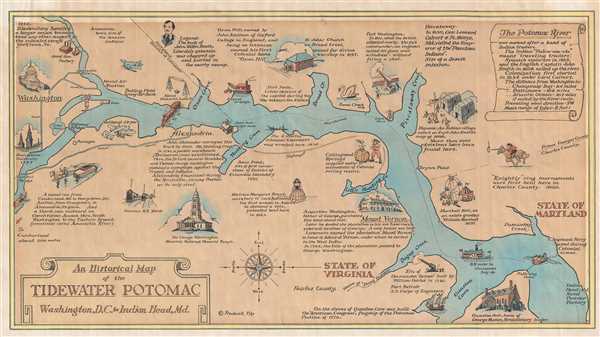
An Historical Map of the Tidewater Potomac Washington, D.C. to Indian Head, Md.
sold
- Digital Map Information
- Suitable for large format printing
- File Size: 3.38 MB
- File Type: ZIP / TIFF
- ICC color profile embedded
- Delivered instantly via download link
This is a 1946 Frederick Tilp map of the Potomac River. The map depicts the river and its environs from Washington, D.C. and Georgetown University to Indian Head, Maryland. Charmingly illustrated, several morsels of ... (more details)
Scottish Pre-WWII flag chart with Third Reich flags.

Brown's Flags of All Nations.
sold
- Digital Map Information
- Suitable for large format printing
- File Size: 19.19 MB
- File Type: ZIP / TIFF
- ICC color profile embedded
- Delivered instantly via download link
This is Brown, Son and Ferguson's c. 1934 chart of the flags of all nations. A dramatic large format chart illustrating the flags of the world's maritime nations with a focus on the British Empire and its various ... (more details)
Illustrates numerous sites around the city which date back to the Roman Empire.
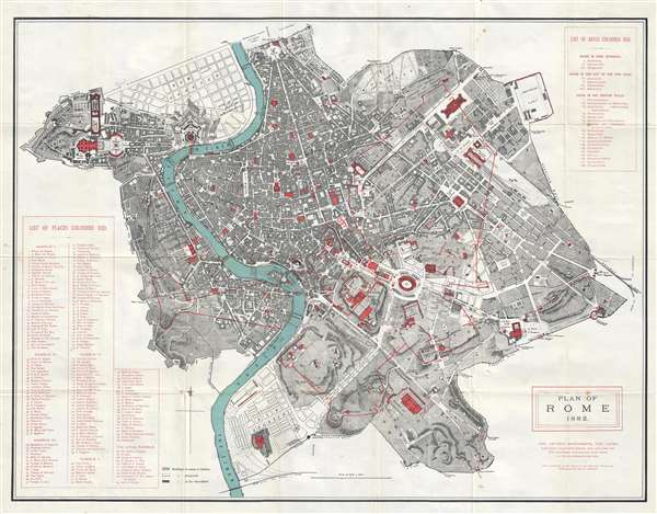
Plan of Rome.
sold
- Digital Map Information
- Suitable for large format printing
- Full resolution TIFF file
- ICC color profile embedded
- Delivered instantly via download link
This is an 1882 Thomas Nelson city map or plan of Rome, Italy, illustrating ancient monuments. The map depicts the city from the Vatican to the Aurelian Wall and from the Villa Borghese and the Piazza del Popolo ... (more details)
Includes a fantastic depiction of Stanford University.
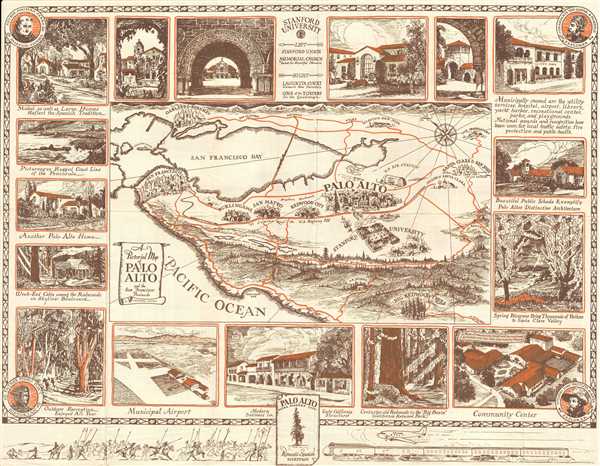
A Pictorial Map of Palo Alto and the San Francisco Peninsula.
sold
- Digital Map Information
- Suitable for large format printing
- File Size: 6.61 MB
- File Type: ZIP / TIFF
- ICC color profile embedded
- Delivered instantly via download link
This is a 1939 Arthur Lites pictorial map of Palo Alto, California and the surrounding area. The map depicts the region from the Golden Gate to the Lick Observatory and from Oakland and Berkeley to Half Moon ... (more details)