
Where Blackbeard's flagship 'The Queen Anne's Revenge' ran aground!
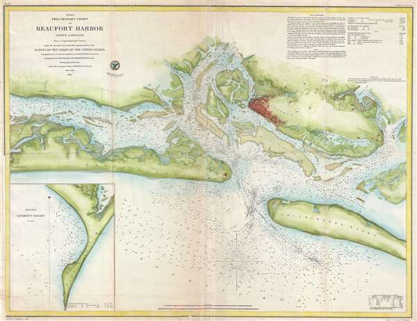
Preliminary Chart of Beaufort Harbor North Carolina.
sold
- Digital Map Information
- Suitable for large format printing
- DPI: 300
- File Size: 15.03 MB
- File Type: ZIP / TIFF
- ICC color profile embedded
- Delivered instantly via download link
This is a scarce hand-colored 1854 U.S.C.S. maritime map or nautical chart of Beaufort Harbor, North Carolina. The chart depicts the North Carolina coast from Carolina City westward through Beaufort as far as Lenoxville Point. It features superb inland detail of ... (more details)
Beautiful map of Tunisia illustrating Roman ruins!
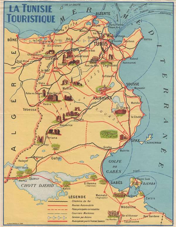
La Tunisie Touristique.
sold
- Digital Map Information
- Suitable for large format printing
- File Size: 1.64 MB
- File Type: ZIP / TIFF
- ICC color profile embedded
- Delivered instantly via download link
This is a c. 1937 Imprimerie Gaillac-Monrocq. pictorial map of Tunisia. The map depicts the region from the Mediterranean Sea to the Chott el-Jérid (Chott Djerid) and from Algeria to the Mediterranean Sea. Numerous cities and towns are labeled, including Tunis, ... (more details)
Depicts the Old North Church and the Bunker Hill Monument!
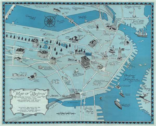
Map of Boston Showing Things That Are, Things That Were, and Glorifying the Bent Streets of Old Boston.
sold
- Digital Map Information
- Suitable for large format printing
- File Size: 9.77 MB
- File Type: ZIP / TIFF
- ICC color profile embedded
- Delivered instantly via download link
This is a 1926 Filene’s Sons and Company pictorial map of Boston, Massachusetts. The map depicts the city of Boston from Cambridge and the Charles River Basin to the Fort Point Channel and South Boston and from Huntington Avenue and Copley Plaza to Boston ... (more details)
Illustrates the Battle for Mexico City during the Mexican-American War!

Plan Accompanying Gen. Quitman's Report.
sold
- Digital Map Information
- Suitable for large format printing
- DPI: 300
- File Size: 6.12 MB
- File Type: ZIP / TIFF
- ICC color profile embedded
- Delivered instantly via download link
This is an 1847 map of The Battle of Chapultepec and the fall of Mexico City during the Mexican-American War. The map depicts the region from just west and southwest of Chapultepec Castle, which guards the western approaches of Mexico City to Mexico City ... (more details)
Beautiful map of the wine region where Beaujolais and Beaujolais nouveau are made!

Le Beaujolais.
sold
- Digital Map Information
- Suitable for large format printing
- File Size: 16.7 MB
- File Type: ZIP / TIFF
- ICC color profile embedded
- Delivered instantly via download link
This is a c. 1955 Henri Grisot pictorial map of the Beaujolais wine region of France. The map depicts the region from Chasselas, Chaintré, and Aigueperse to Ancy and the confluence of La Brevenne and La Turdine and from Thizy and Mardore to Villefranche ... (more details)
Boasts beautifully sketched vignette views of the Cincinnati Court House, the new Post Office, and the Cincinnati Enquirer building!
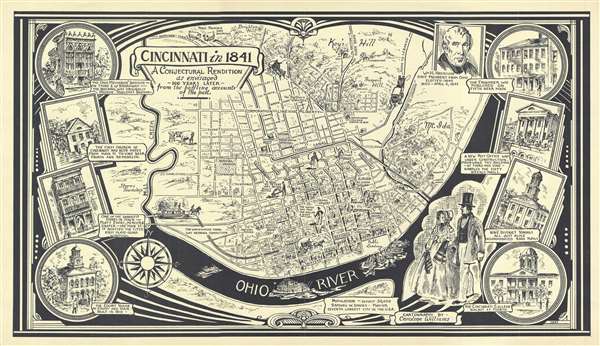
Cincinnati in 1841. A Conjectural Rendition as envisaged 100 years later from the baffling accounts of the past.
sold
- Digital Map Information
- Suitable for large format printing
- File Size: 6.46 MB
- File Type: ZIP / TIFF
- ICC color profile embedded
- Delivered instantly via download link
This is a 1941 Caroline Williams pictorial map of Cincinnati, Ohio in 1841. The map depicts Cincinnati from Key's Hill and Brighton Hill to the Ohio River and from Mill Creek to Mt. Ida and the Ohio River. Beautifully sketched, details of downtown ... (more details)
Amusing pictorial map of the United States with its various legends and folklore.

Folklore and Legends of Our Country.
sold
- Digital Map Information
- Suitable for large format printing
- Full resolution TIFF file
- ICC color profile embedded
- Delivered instantly via download link
This is an appealing and colorful 1962 Esso pictorial map of the United States illustrated with our national folklore and legends. Recognizable figures include Paul Bunyan and his great Blue Ox, Long Jon Silver, Moby Dick, Jonny Appleseed, the ... (more details)
Details the presidential election of 1880!
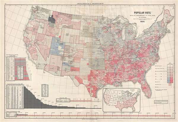
Popular Vote. Ratio of Predominant to Total Vote, by Counties.
sold
- Digital Map Information
- Suitable for large format printing
- File Size: 11.54 MB
- File Type: ZIP / TIFF
- ICC color profile embedded
- Delivered instantly via download link
This is a Fletcher W. Hewes and Charles Scribner's Sons political map of the United States. The map depicts the continental United States from the Pacific Ocean to the Atlantic Ocean and from the Canadian border to the border with Mexico. ... (more details)
Scarce early map detailing river navigation in Sweden!

Canal of Trolhaetta.
sold
- Digital Map Information
- Suitable for large format printing
- DPI: 300
- File Size: 3.09 MB
- File Type: ZIP / TIFF
- ICC color profile embedded
- Delivered instantly via download link
This is a 1784 Thomas Kitchin map or plan of the proposed route for the Trollhätte Canal in Sweden. The map depicts the Gotha River (Göta älv) south from Trolhaetta (Trollhättan) and through the cataracts or rapids south of the city. ... (more details)
Rare map of the Virgin Islands with slave trade content, shipwrecks, and Necker Island!
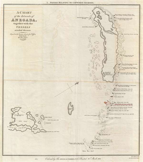
A Chart of the Island of Anegada, together with the Vessels wrecked thereon.
sold
- Digital Map Information
- Suitable for large format printing
- DPI: 300
- File Size: 4.13 MB
- File Type: ZIP / TIFF
- ICC color profile embedded
- Delivered instantly via download link
This is a rare 1825 map of Anegada Island, the northernmost of the British Virgin Islands, illustrating shipwrecks occurring between 1799 and 1823. This map was specifically prepared to illustrate the wreck of the Donna Paula , which is ... (more details)
Delightfully illustrated airline route map!

TAI Transports Aeriens Intercontinentaux.
sold
- Digital Map Information
- Suitable for large format printing
- File Size: 16.41 MB
- File Type: ZIP / TIFF
- ICC color profile embedded
- Delivered instantly via download link
This is a 1959 Luc-Marie Bayle route map of the world created for Transports Aériens Intercontinentaux (TAI), a private French airline which operated from the early 1950s until it merged with Union Aéromaritime de Transport in October ... (more details)
A visually striking map of the Pacific Northwest, including Seattle, Tacoma, and Olympia.
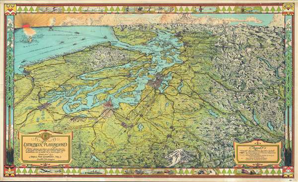
The Evergreen Playground. Neither Europe nor Asia nor South America has a prospect in which sea and woods and snow mountains are so united in a landscape.
sold
- Digital Map Information
- Suitable for large format printing
- File Size: 22.53 MB
- File Type: ZIP / TIFF
- ICC color profile embedded
- Delivered instantly via download link
This is a 1945 Kroll Map Company pictorial map of Puget Sound and the surrounding region, including Seattle, Tacoma, and Olympia, Washington, and Vancouver, British Columbia. Oriented to the west-northwest, the map depicts from the ... (more details)
Includes possible hunting ranges for native animals - including bears and caribou!
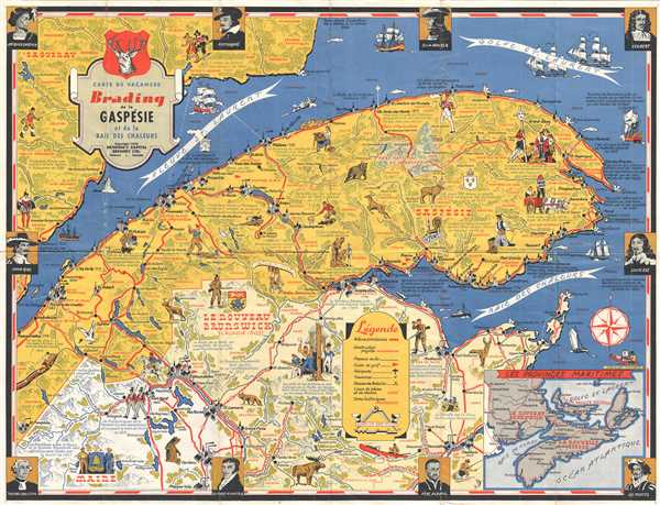
Carte de Vacances Brading de la Gaspésie et de la Baie des Chaleurs.
sold
- Digital Map Information
- Suitable for large format printing
- File Size: 11.43 MB
- File Type: ZIP / TIFF
- ICC color profile embedded
- Delivered instantly via download link
This is a Stanley Turner pictorial map of the Gaspésie Peninsula in Canada. The map depicts from Saint Siméon in Québec to Saint Laurence Bay and the Baie des Chaleurs and from the Saguenay region of Québec to Maine. A ... (more details)
Exceptional French comparative mountains and rivers chart after Bulla.
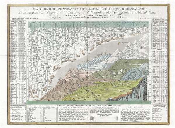
Tableau Comparatif de la Hauteur des Montagnes de la Longueur de Cours des Fleuves.
sold
- Digital Map Information
- Suitable for large format printing
- DPI: 300
- File Size: 13.32 MB
- File Type: ZIP / TIFF
- ICC color profile embedded
- Delivered instantly via download link
This is Charles V. Monin's 1838 comparative mountains and rivers chart. This extraordinary chart is considered the highest expression of the mountains and rivers convention as developed in the 19th century. It is a vast, ... (more details)
Exceptional map of Asia showing both East Sea and Sea of Korea.

Carte des Indes et de la Chine.
sold
- Digital Map Information
- Suitable for large format printing
- Full resolution TIFF file
- ICC color profile embedded
- Delivered instantly via download link
An exceptional 1705 map of the East India Islands by Guillaume Delisle. Centered on China, Delisle’s map depicts from the Caspian Sea to the semi-mythical Terre de la Compagnie and India to New Guinea. Extraordinary ... (more details)
Created for the Berkshire Life Insurance Company!

Railway and Highway Map of the Famous Berkshire Hills Region, Showing Villages and also Points of Interest.
sold
- Digital Map Information
- Suitable for large format printing
- Full resolution TIFF file
- ICC color profile embedded
- Delivered instantly via download link
This is a highly desirable 1896 map of the Berkshires or the Berkshire Hills in Massachusetts, by Walter Watson C. E. It covers Berkshire County, located in the western most part of the state of Massachusetts. Parts ... (more details)
Chart noting the proposed site of the Point Conception Light on the southwestern coast near Santa Barbara, California.

Sketch J No. 3 Point Conception Coast of California.
sold
- Digital Map Information
- Suitable for large format printing
- DPI: 300
- File Size: 1.54 MB
- File Type: ZIP / TIFF
- ICC color profile embedded
- Delivered instantly via download link
This is a nice example of the 1851 U.S. Coast Survey chart or map of Point Conception on the California Coast, where the Santa Barbara Channel meets the Pacific Ocean. The map is beautifully detailed with some inland ... (more details)
Uncommon French nautical chart of the Virgin Islands.
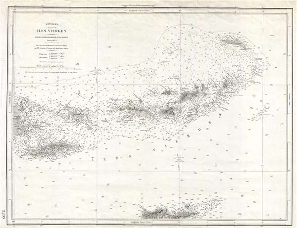
Antilles. Iles Vierges.
sold
- Digital Map Information
- Suitable for large format printing
- File Size: 8.27 MB
- File Type: ZIP / TIFF
- ICC color profile embedded
- Delivered instantly via download link
An uncommon French Dépôt de la Marine nautical chart or maritime map of the Virgin Islands. The map covers the entirety of the Virgin Islands from Porto Rico to I. Anegada and extends as far south as St. Croix. ... (more details)
The first surveyed map of Karachi, Pakistan, issued by the East India Company exploratory mission to Sinde in preparation for the February 1839 occupation.
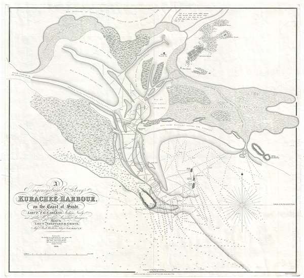
A Trigonometrical Survey of Kurachee Harbour, on the Coast of Sinde.
sold
- Digital Map Information
- Suitable for large format printing
- DPI: 300
- File Size: 12.67 MB
- File Type: ZIP / TIFF
- ICC color profile embedded
- Delivered instantly via download link
This is the first map of Karachi city and harbor, modern day Pakistan, drawn from Thomas Greer Carless' exploratory surveys of 1838. Carless, along with fellow India Navy Officers W. Jardine, Sheppard, and Grieve, ... (more details)
Wonderful decorative map of the French Alsace Wine Region, home of superb Rieslings and highly aromatic Gewürztraminer wines!

Vignoble Alsacien.
sold
- Digital Map Information
- Suitable for large format printing
- File Size: 20.56 MB
- File Type: ZIP / TIFF
- ICC color profile embedded
- Delivered instantly via download link
A rare decorative 1949 Louis Larmat map of the Alsace wine region on the left bank of the Rhine between Strasbourg and Mulhouse. All of the major wine growing areas and vineyards are highlighted in red. This ... (more details)