
Iconic and hilarious pictorial map of the United States as imaged by a New Yorker in the 1930s.
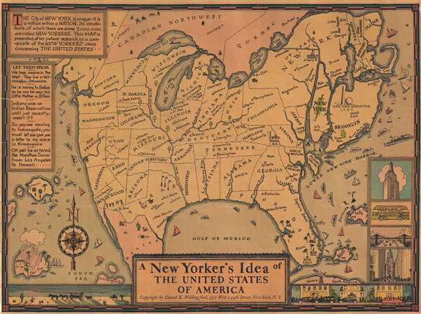
A New Yorker's Idea of The United States of America
sold
- Digital Map Information
- Suitable for large format printing
- File Size: 5.81 MB
- File Type: ZIP / TIFF
- ICC color profile embedded
- Delivered instantly via download link
This is a whimsical 1939 Daniel K. Wallingford pictorial map depicting a New Yorker's idea of the United States. Wallingford presents a humorously a distorted view of the United States, wherein New York State, Manhattan and Brooklyn, and other areas frequented by New Yorkers (Florida, Bermuda, etc.), are vastly outsized in proportion to the rest of the country. This edition was issued for the 1939 New York World's Fair, which is illustrated just north of Brooklyn. (more details)
Incredible look at 42nd Street just after the Civil War.

View from School House in 42nd Street Between 2nd and 3rd Avs. Looking North.
sold
- Digital Map Information
- Suitable for large format printing
- File Size: 1.18 MB
- File Type: ZIP / TIFF
- ICC color profile embedded
- Delivered instantly via download link
This is an intriguing 1868 Shannon and Rogers view of 42nd Street between 2nd and 3rd Avenues in Midtown East, Manhattan, New York City. The view depicts the neighborhood looking north across 42nd Street. Various farm animals, including goats, pigs, and chickens ... (more details)
Attractive view of New York City's historically significant Printing House Square.

Printing House Square 1868.
sold
- Digital Map Information
- Suitable for large format printing
- File Size: 0.95 MB
- File Type: ZIP / TIFF
- ICC color profile embedded
- Delivered instantly via download link
This is a beautiful 1868 Shannon and Rogers view of the Printing House Square or what is today Park Row near the southern triangle of City Hall Park, New York City by Shannon and Rogers. It depicts what was at the time known as Printing House Square, a ... (more details)
Charming view of Sixth Avenue in Midtown Manhattan c. 1868.

View in Sixth Avenue, Between 55th and 57th Sts. Looking West.
sold
- Digital Map Information
- Suitable for large format printing
- File Size: 1.22 MB
- File Type: ZIP / TIFF
- ICC color profile embedded
- Delivered instantly via download link
This is a beautiful 1868 Shannon and Rogers view looking westward from Sixth Avenue between 55th and 57th streets in what is now Midtown Manhattan, New York City. The view gives an interesting snapshot of what this area looked like in the middle of the ... (more details)
Beautiful early view of Central Park's iconic Bow Bridge.

Central Park. The Lake and The Bow Bridge.
sold
- Digital Map Information
- Suitable for large format printing
- File Size: 0.94 MB
- File Type: ZIP / TIFF
- ICC color profile embedded
- Delivered instantly via download link
This is a lovely 1868 Shannon and Rogers view of the Bow Bridge and the Lake in Central Park, by Shannon and Rogers. The Bow Bridge, built in 1862 is located roughly at 74th street in the heart of New York City’s Central Park and connects the Ramble ... (more details)
A very scarce Admiralty nautical chart depicting Siberia not far from Vladivostok!
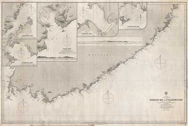
Strelok Bay to St. Vladimir Bay
sold
- Digital Map Information
- Suitable for large format printing
- File Size: 24.84 MB
- File Type: ZIP / TIFF
- ICC color profile embedded
- Delivered instantly via download link
This is a rare 1868 Admiralty nautical chart or maritime map of the Pacific coast of Russian Manchuria, just east of Valdivostok. The map depicts the coastline in great detail from Nakhodka to St. Vladimir Bay (Zaliv Vladimira). Numerous locations are ... (more details)
A map criticizing the construction of brick sewers in San Francisco's Financial District.

Diagram of a Part of the City Showing Excessive and Needless Construction of Brick Sewers.
sold
- Digital Map Information
- Suitable for large format printing
- File Size: 1.38 MB
- File Type: ZIP / TIFF
- ICC color profile embedded
- Delivered instantly via download link
This is an 1893 San Francisco Board of Supervisors map of the Financial District in San Francisco, California. The map depicts the city from Kearney Street to East Street and the wharves along San Francisco Bay and from Jackson Street to Market ... (more details)
Planning a city isn't always easy!
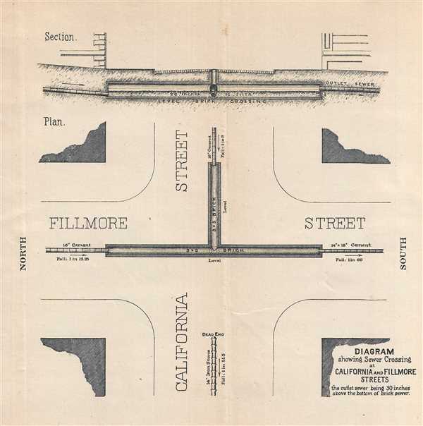
Diagram showing Sewer Crossing at California and Fillmore Streets.
sold
- Digital Map Information
- Suitable for large format printing
- File Size: 0.91 MB
- File Type: ZIP / TIFF
- ICC color profile embedded
- Delivered instantly via download link
This is an 1893 San Francisco Board of Supervisors map of the intersection of Fillmore and California Streets in San Francisco, California. The map depicts the intersection from the west, with north on the left side to illustrate the sewer ... (more details)
A very scarce English edition of one of the first American maps to extend to the Mississippi River.
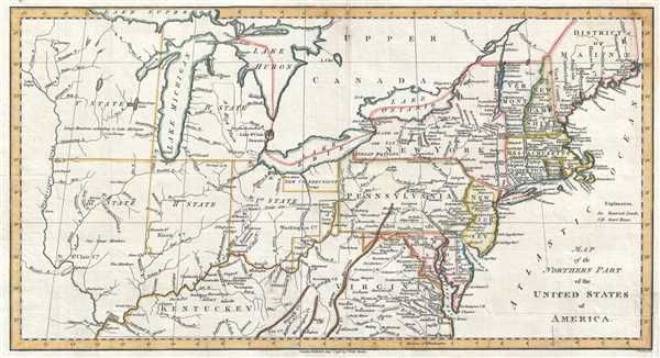
Map of the Northern Part of the United States of America.
sold
- Digital Map Information
- Suitable for large format printing
- DPI: 300
- File Size: 3.04 MB
- File Type: ZIP / TIFF
- ICC color profile embedded
- Delivered instantly via download link
This is a scarce and significant early 1802 postal route map of the northern parts of the United States illustrating postal routes and the five Jeffersonian states proposed by the Ordinance of 1789. The present example is the 1802 ... (more details)
One of the earliest American maps to extend to the Mississippi. Illustrates early postal routes and the Connecticut Western Reserve.
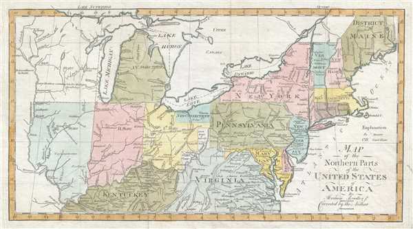
Map of the Northern Parts of the United States of America. By Abraham Bradley Jr. Corrected by the Author.
sold
- Digital Map Information
- Suitable for large format printing
- DPI: 300
- File Size: 3.5 MB
- File Type: ZIP / TIFF
- ICC color profile embedded
- Delivered instantly via download link
This is a scarce and significant early 1802 postal route map of the northern parts of the United States illustrating postal routes and the five Jeffersonian states proposed by the Ordinance of 1789. The present example is the 1802 ... (more details)
Incredible map with several advertisements geared toward cyclists!

Carte Officielle FOLDEX du Tour de France.
sold
- Digital Map Information
- Suitable for large format printing
- File Size: 34.78 MB
- File Type: ZIP / TIFF
- ICC color profile embedded
- Delivered instantly via download link
This is a 1950 Foldex and La Voix du Nord route map of the Tour de France cycling race. The map depicts France and the surrounding countries from the Atlantic Ocean to Italy, Switzerland, and Belgium and from the English Channel to ... (more details)
Proto-Discovery of Great Salt Lake?

North America, Drawn from the Best Authorities by J. Russell.
sold
- Digital Map Information
- Suitable for large format printing
- DPI: 300
- File Size: 7.01 MB
- File Type: ZIP / TIFF
- ICC color profile embedded
- Delivered instantly via download link
A most fascinating 1811 John Russell map of North America with an intriguing mapping of Great Salt Lake issued just prior the development of the Western Fur Trade and the seminal explorations of Zebulon Pike (1779 - 1813), Stephen Harriman Long (1874 - 1864), and Jedidiah Smith (1799 - 1831). The map postdates the Lewis and Clark Expedition (1803 - 1806), but reconnaissance from that voyage is nowhere in evidence. Instead, the map details the dubious voyage of 'Mr. Lawrence' (see below). Coverage from the Pacific Ocean to the Atlantic Ocean and from Baffin Bay and northern Canada to the extreme northern reaches of South America. The extreme northern portion of North America, above the Arctic Circle, is incomplete, but the Arctic coast is slowing being filled in. The map further identifies the first two European overland expeditions to the North American Arctic, those of Herne and Mackenzie. The United States, still limited to the lands east of the Mississippi and north of Florida, has 15 states, reflecting the addition of Vermont (1791) and Kentucky (1792). (more details)
The Mackenzie and Coppermine river systems illustrated with impressive detail!
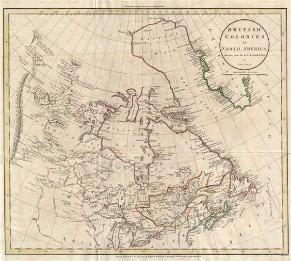
British Colonies in North America.
sold
- Digital Map Information
- Suitable for large format printing
- DPI: 300
- File Size: 6.52 MB
- File Type: ZIP / TIFF
- ICC color profile embedded
- Delivered instantly via download link
This is an 1811 John Russell map of Canada. The map depicts the region from the 'Stony Mountains' (Rocky Mountains) to the Atlantic Ocean and from Baffin's Bay and Greenland to the northern United States, including the Great Lakes. ... (more details)
Map of the West Indies just prior to the War of 1812.
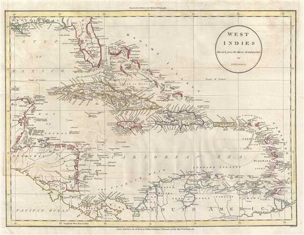
West Indies.
sold
- Digital Map Information
- Suitable for large format printing
- DPI: 300
- File Size: 6.7 MB
- File Type: ZIP / TIFF
- ICC color profile embedded
- Delivered instantly via download link
This is an 1811 John Russell map of the West Indies and Central America. The map depicts the region from the Yucatan Peninsula to the Lesser Antilles and from Florida to northern South America, including Colombia and Venezuela. A ... (more details)
A visually captivating piece celebrating Burgundy wines!

Carte des Vins de Bourgogne.
sold
- Digital Map Information
- Suitable for large format printing
- File Size: 11.92 MB
- File Type: ZIP / TIFF
- ICC color profile embedded
- Delivered instantly via download link
This is an anonymous c. 1950 map of the Bourgogne (Burgundy) wine region in France. The map depicts the region around the Yonne River, Auxerre, and Chablis, as well as the region from the Ouche River and Dijon, along the Saône ... (more details)
Thematic agricultural map detailing wheat growing regions in Washington State.
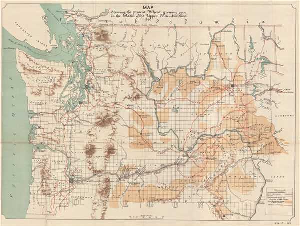
Map Szhowing the present Wheat growing area in the Basin of the Upper Columbia River.
sold
- Digital Map Information
- Suitable for large format printing
- File Size: 11.25 MB
- File Type: ZIP / TIFF
- ICC color profile embedded
- Delivered instantly via download link
This is an 1892 U. S. Government map of Washington State. The map depicts the region from the Pacific Ocean and Vancouver Island to Idaho and from British Columbia to Oregon. A highly detailed land-use map, it illustrates the ... (more details)
Tarrytown - the setting for the iconic 19th century short story 'The Legend of Sleepy Hollow'!
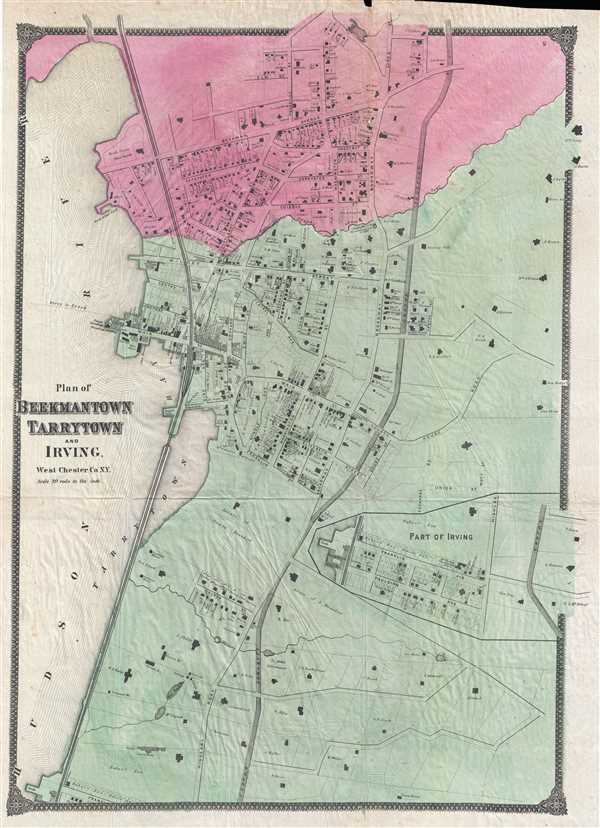
Plan of Beekmantown Tarrytown and Irving West Chester Co. N.Y.
sold
- Digital Map Information
- Suitable for large format printing
- File Size: 10.64 MB
- File Type: ZIP / TIFF
- ICC color profile embedded
- Delivered instantly via download link
This is an 1867 Frederic Beers map of Beekmantown, Tarrytown, and Irving, New York. The map depicts the region along the Hudson River known as the Tappen Zee in extraordinary detail, with individual buildings (with the names ... (more details)
One of the most beautiful old color large format 19th century maps of Paris.
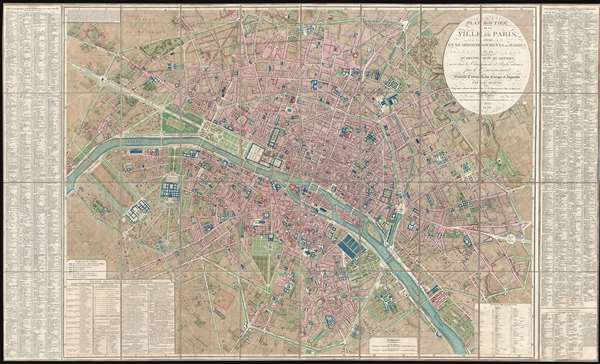
Plan Routier de la Ville de Paris, divise en XII Arrondissements ou Mairies et en Quarante Huit Quartiers, avec tous le Changements et Projets ordonnes par le Gouvernement.
sold
- Digital Map Information
- Suitable for large format printing
- DPI: 300
- File Size: 86.66 MB
- File Type: ZIP / TIFF
- ICC color profile embedded
- Delivered instantly via download link
This is a stunning large format map of Paris issued in 1839 by Pierre-Jacques Picquet. Centered on the Seine River, the map covers from the Champ de Mars eastward to Place du Trone. This map was first issued for ... (more details)
The most beautiful old color example of Zurner's transitional map of America we have seen!

Americae tam Septentrionalis quam Meridionalis in Mappa Geographica Delineatio…
sold
- Digital Map Information
- Suitable for large format printing
- DPI: 300
- File Size: 18.42 MB
- File Type: ZIP / TIFF
- ICC color profile embedded
- Delivered instantly via download link
Probably the most beautiful old color example of Adam Friedrich Zurner and Pieter Schenk's 1709 map of the Americas. The map covers all of North America and South America, with California as an island, as well as ... (more details)
Rare American World War II Propaganda Broadside - promotes American defense before Pearl Harbor!
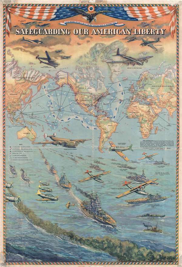
Safeguarding Our American Liberty.
sold
- Digital Map Information
- Suitable for large format printing
- File Size: 28.62 MB
- File Type: ZIP / TIFF
- ICC color profile embedded
- Delivered instantly via download link
This is a 1941 Lambert Guenther propaganda broadside map of the world extolling American defensive preparedness on the brink of World War II. This broadside was issued to promote the belief that, even as war raged ... (more details)