
Vivid and rare thematic map with Calcutta imprint.

Fauna of India and Adjacent Countires.
sold
- Digital Map Information
- Suitable for large format printing
- File Size: 21.68 MB
- File Type: ZIP / TIFF
- ICC color profile embedded
- Delivered instantly via download link
A scarce and colorful large format map of India illustrating fauna. This richly illustrated map covers India from the Himalayas to Sri Lanka and from the Indus Valley to Burma. It is lavishly illustrated with animal life typical of the region. There is a ... (more details)
Extensive railway map of the United States and its territories (including the Philippines!), Canada, and Mexico.
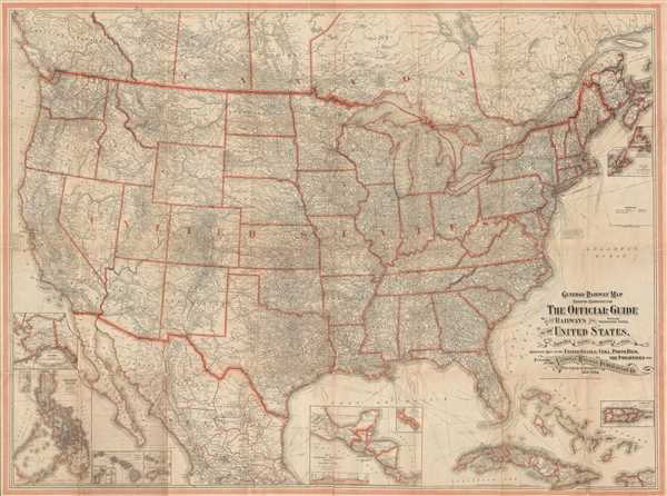
General Railway Map Engraved Expressly for The Official Guide of the Railways and Steam Navigation Lines, of the United States, Porto Rico, Canada, Mexico, and Cuba. Comprising Maps of the United States, Cuba, Porto Rico, the Philippines, etc.
sold
- Digital Map Information
- Suitable for large format printing
- File Size: 64.36 MB
- File Type: ZIP / TIFF
- ICC color profile embedded
- Delivered instantly via download link
This is a 1918 National Railway Publication Company railway map of the United States, Canada, Mexico, Cuba, and the Philippines. The map depicts North America from southern Canada to Mexico City and from the Pacific to the Atlantic. As a highly detailed ... (more details)
Rare Bird's-Eye View of Lower Manhattan showing early stages of New York's skyscraper building phase. Also shows the RMS Titanic!

[Birdseye View of Lower Manhattan]
sold
- Digital Map Information
- Suitable for large format printing
- File Size: 14.59 MB
- File Type: ZIP / TIFF
- ICC color profile embedded
- Delivered instantly via download link
A fine chromolithograph bird's--eye view of lower Manhattan, New York City, drawn by watercolorist Richard Rummell and copyrighted in 1911 by the Copr. Detroit Publishing Company. The view presents a dramatic image of New York City's thriving ... (more details)
Large early nautical chart of the world showing Californai as an island and embryonic Australia.
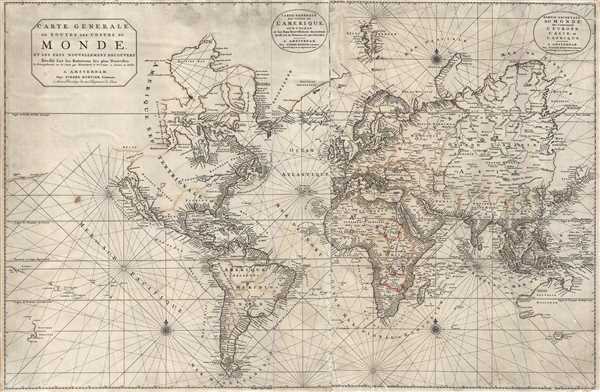
Carte Generale de Toutes Les Costes Du Monde et Les Pays Nouvellement Decouvert, Dresse sur les Relations les Plus Nouvelles Et Principalement sur la Carte que Monsieur N Witsen, a done au Public. / Carte Generale des costes de L'Amerique sur L'Ocean, et les Pays Nouvellement decouvert, Dresse sur les Relations les plus Nouvelles. / Partie Orientale du Monde, qui Contiennent L'Europe, L'Asie, et L'Afrique.
sold
- Digital Map Information
- Suitable for large format printing
- DPI: 300
- File Size: 19.72 MB
- File Type: ZIP / TIFF
- ICC color profile embedded
- Delivered instantly via download link
This is Pierre Mortier's 1703 large format nautical chart of the world on a Mercator Projection. Centered on the Atlantic, this impressive chart covers the entire world as it was then known. Rhumb lines appear throughout and the coastlines ... (more details)
Stunning Japanese chromolithograph Sugoroku gameboard.

Tetsudō kyōsō Sugoroku [Railway Race Sugoroku].
sold
- Digital Map Information
- Suitable for large format printing
- File Size: 38.84 MB
- File Type: ZIP / TIFF
- ICC color profile embedded
- Delivered instantly via download link
A scarce and dramatically produced c. 1925 (Taisho 14) board for the Japanese game known as sugoroku . The board depicts the islands of Japan oriented in a northwesterly direction - as was common in railway maps of the period. The essence of ... (more details)
The earliest obtainable map or plan of New Orleans, Louisiana.

Plan de la Nouvelle Orleans. Sur les Manuscrits du Depôt des Cartes de la Marine.
sold
- Digital Map Information
- Suitable for large format printing
- Full resolution TIFF file
- ICC color profile embedded
- Delivered instantly via download link
This scarce 1744 map by J. N. Bellin is the earliest obtainable map of New Orleans, Louisiana. Oriented to the northwest, Bellin's map covers the original settlement of New Orleans along the Mississippi River and inland as far the Fosse plein ... (more details)
Uncommon pictorial map of Ireland.

Story Map of Ireland.
sold
- Digital Map Information
- Suitable for large format printing
- File Size: 9.93 MB
- File Type: ZIP / TIFF
- ICC color profile embedded
- Delivered instantly via download link
An uncommon 1937 pictorial map of Ireland by the Chicago firm Colortext. The map covers all of Ireland with historical and literary figures highlighted with profile images near the locations with which they are most associated. The border ... (more details)
Engraved in an unusual topographic style.
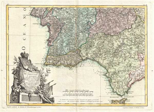
Mapa dos Reynos de Portugal e Algarve.
sold
- Digital Map Information
- Suitable for large format printing
- DPI: 300
- File Size: 6.64 MB
- File Type: ZIP / TIFF
- ICC color profile embedded
- Delivered instantly via download link
This is a 1775 Giovanni Antonio Rizzi Zannoni map of southern Portugal, the Algarve, and southwestern Spain. The map depicts from Lisbon to Gibraltar and from the Atlantic Ocean to Andorra, Spain. Engraved in a highly unusual topographic ... (more details)
Includes an inset map of the Panama Canal!

U.S. Coast and Geodetic Survey Progress of Field Work Hawaiian Islands Fiscal Year 1926.
sold
- Digital Map Information
- Suitable for large format printing
- File Size: 3.37 MB
- File Type: ZIP / TIFF
- ICC color profile embedded
- Delivered instantly via download link
This is a 1926 U.S. Coast and Geodetic Survey map of the Hawaiian Islands. The map depicts and labels the main Hawaiian Islands of Hawaii, Maui, Lanai, Molokai, Oahu, Kauai, and Nihau. Several channels between the islands are also ... (more details)
Depicts Cabanatuan - infamous for its proximity to a Japanese prison camp during WWII.
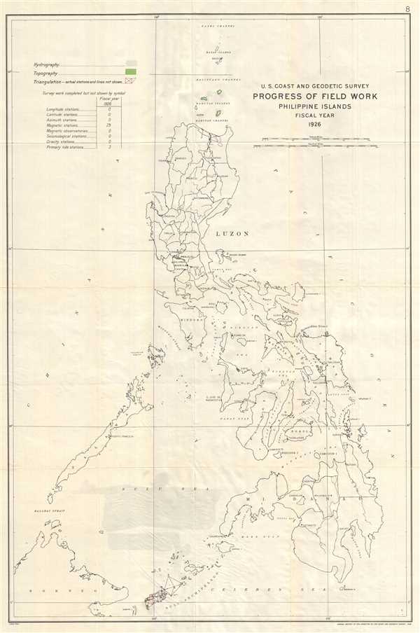
U.S. Coast and Geodetic Survey Progress of Field Work Philippine Islands Fiscal Year 1926.
sold
- Digital Map Information
- Suitable for large format printing
- File Size: 7.73 MB
- File Type: ZIP / TIFF
- ICC color profile embedded
- Delivered instantly via download link
This is a 1926 U.S. Coast and Geodetic Survey map of the Philippines. The map depicts the Philippine Islands from the Bashi Channel to the Sulu Archipelago, the Celebes Sea, and Borneo and from the China Sea to the Pacific Ocean. ... (more details)
Stunning chromolithograph of the battle that ended Spanish rule in the Philippines.
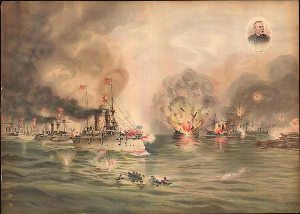
The Battle of Manila, May 1, 1898.
sold
- Digital Map Information
- Suitable for large format printing
- File Size: 11.67 MB
- File Type: ZIP / TIFF
- ICC color profile embedded
- Delivered instantly via download link
A rare Xanthus Russell Smith chromolithograph of the 1898 Battle of Manila, a pivotal event in the Spanish American War. The view shows the American Asiatic Squadron led by its flagship, the Olympia, bombarding the Spanish ... (more details)
The map and book that named Louisiana.
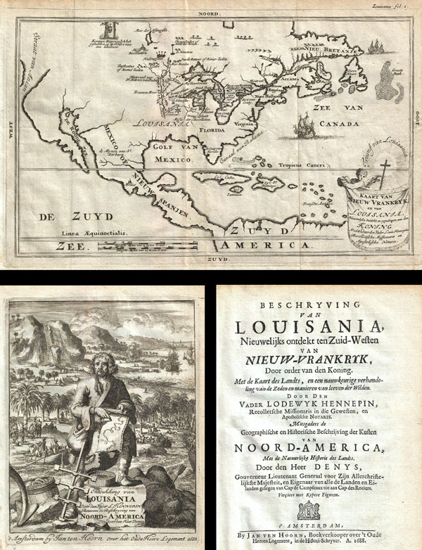
Kaart van Nieuw Vrankryk, en van Louisania Nieuwelyks Ontdekt.
sold
- Digital Map Information
- Suitable for large format printing
- DPI: 300
- File Size: 5.94 MB
- File Type: ZIP / TIFF
- ICC color profile embedded
- Delivered instantly via download link
A work that fundamentally impacted the cartographic history of America, this is the 1688 first Dutch edition of Friar Hennepin's most important work describing his explorations through the Great Lakes and the upper ... (more details)
A pictorial map of Shelter Island by Shelter Island local Edith Hawkins Sheperd.
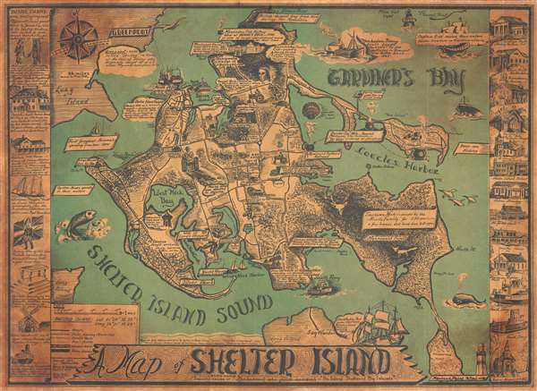
A Map of Shelter Island.
sold
- Digital Map Information
- Suitable for large format printing
- File Size: 12.48 MB
- File Type: ZIP / TIFF
- ICC color profile embedded
- Delivered instantly via download link
This is Edith Hawkins Shepherd's rare 1966 pictorial map of Shelter Island, Long Island. Shelter Island is 'sheltered' between the north and south forks of Long Island and retains much of its traditional charm ... (more details)
Early manuscript star chart integrating Korean, Chinese, and western astronomical / astrological science.

[Chinese Celestial]
sold
- Digital Map Information
- Suitable for large format printing
- DPI: 300
- File Size: 33.22 MB
- File Type: ZIP / TIFF
- ICC color profile embedded
- Delivered instantly via download link
A rare c. 1800 Korean celestial and zodiacal constellation chart in manuscript. This chart illustrates the traditional Chinese zodiacal system, generally following the Korean Cheonsang Yeolcha Bunyajido (which ... (more details)
A cornerstone map of New Jersey: the first 'official' state map and the first large detailed map of the state. -John Delaney
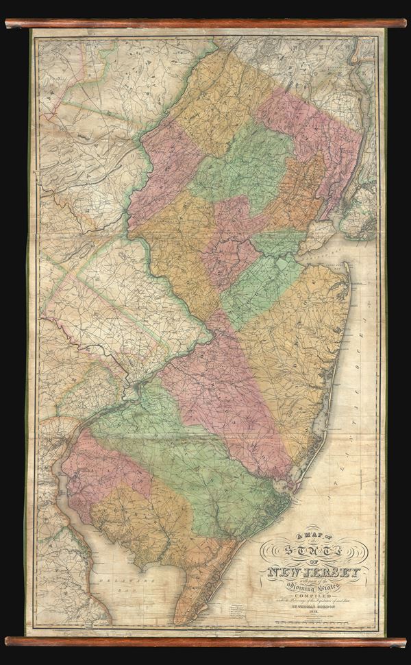
A Map of the State of New Jersey with part of the adjoining states compiled under the Patronage of the Legislature of said State by Thomas Gordon 1828.
sold
A seminal production, this is the first edition, first state, of Thomas Gordon's impressive wall map of New Jersey. This is the first large scale map of New Jersey to be printed in the United States. Gordon's ... (more details)
One of only three known examples of this important early chart covering Florida, Virginia, Georgia, New Jersey, and the Carolinas.
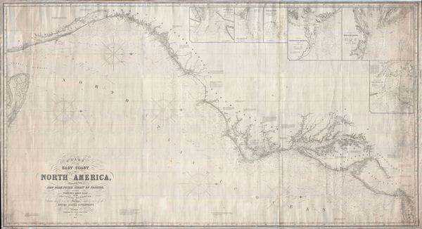
Chart of the East Coast of North America, Extending from New York to the Strait of Florida, including Plans on a Large Scale of the Principal Harbors, Drawn chiefly from the Surveys made by order of the United States Government.
sold
- Digital Map Information
- Suitable for large format printing
- File Size: 94.77 MB
- File Type: ZIP / TIFF
- ICC color profile embedded
- Delivered instantly via download link
An extremely scarce, highly decorative, and monumentally proportioned 1855 sea chart or maritime map detailing the eastern coast of the United States from New York City to southern Florida (roughly around Palm Beach). The map was prepared by the British chart publisher James Imray and Son in their distinctive expansive style. In a broad spread, it includes the coasts of New York, New Jersey, Delaware, Maryland, Virginia, North Carolina, South Carolina, and Florida. The Chesapeake Bay, Delaware Bay, New York Harbor, the Bahama Banks, and the Outer Banks are rendered in beautiful detail. The chart is presented on a Mercator Projection with latitude measured from Greenwich, England. Like most nautical charts, the cartographer offers very little inland detail, but a wealth of maritime data. This includes the identification of various ports and harbors, coastal topography, shoals and other undersea dangers, and countless depth soundings in fathoms.
This chart further features six large insets in the upper right quadrant offering detailed charts of 'Tybee Bay and the Mouth of the Savannah River', 'Cape Fear River and Frying-Pan Shoals', 'Cape Hatteras', 'Charleston Harbor', the 'entrance of the River Delaware', and the 'entrance to Chesapeake Bay'. The cartography of the insets generally follows the preliminary work of the U. S. Coast Survey in their respective regions. (more details)
This chart further features six large insets in the upper right quadrant offering detailed charts of 'Tybee Bay and the Mouth of the Savannah River', 'Cape Fear River and Frying-Pan Shoals', 'Cape Hatteras', 'Charleston Harbor', the 'entrance of the River Delaware', and the 'entrance to Chesapeake Bay'. The cartography of the insets generally follows the preliminary work of the U. S. Coast Survey in their respective regions. (more details)
Map of Japan's largest freshwater lake exhibiting both traditional and modern cartographic conventions.

Ōmi Province [Lake Biwa]
sold
- Digital Map Information
- Suitable for large format printing
- File Size: 52.2 MB
- File Type: ZIP / TIFF
- ICC color profile embedded
- Delivered instantly via download link
This is a scarce Meiji 18 or 1885 Japanese map of Like Biwa (琵琶湖), Ōmi Province (近江国 ), Shiga Prefecture, Japan. The map was issued by Yamaguchi Toshihide. Oriented to the east and centered on ... (more details)
Important Sheafer historical map of Pennsylvania depicting the growth of the state.
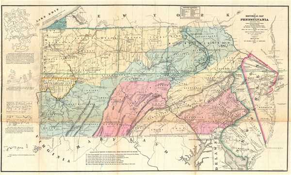
An Historical Map of Pennsylvania showing the Indian Names of Streams and Villages, and Paths of Travel; the Sites of Old Forts and Battle Fields; the Successive Purchases from the Indians; and the Names and Dates of Counties and County Towns, with Tables of Forts and Proprietary Manors.
sold
- Digital Map Information
- Suitable for large format printing
- File Size: 18.61 MB
- File Type: ZIP / TIFF
- ICC color profile embedded
- Delivered instantly via download link
This is an 1875 P. W. Sheafer map of Pennsylvania. The map depicts the state of Pennsylvania from the border with Ohio to New Jersey, Long Island, and the Atlantic Ocean and from the border with New York to ... (more details)
A gorgeous bird's eye view of Narragansett Bay - including Providence!

Narragansett Bay.
sold
- Digital Map Information
- Suitable for large format printing
- File Size: 24.13 MB
- File Type: ZIP / TIFF
- ICC color profile embedded
- Delivered instantly via download link
This is an attractive and uncommon c. 1900 bird's eye view map of Narragansett Bay, Rhode Island. The view covers the entirety of Narragansett Bay from Point Judith to Providence, and extending eastwards as ... (more details)
Conservation Commission map of Lake George and Lake Champlain with a reminder to help prevent forest fires!
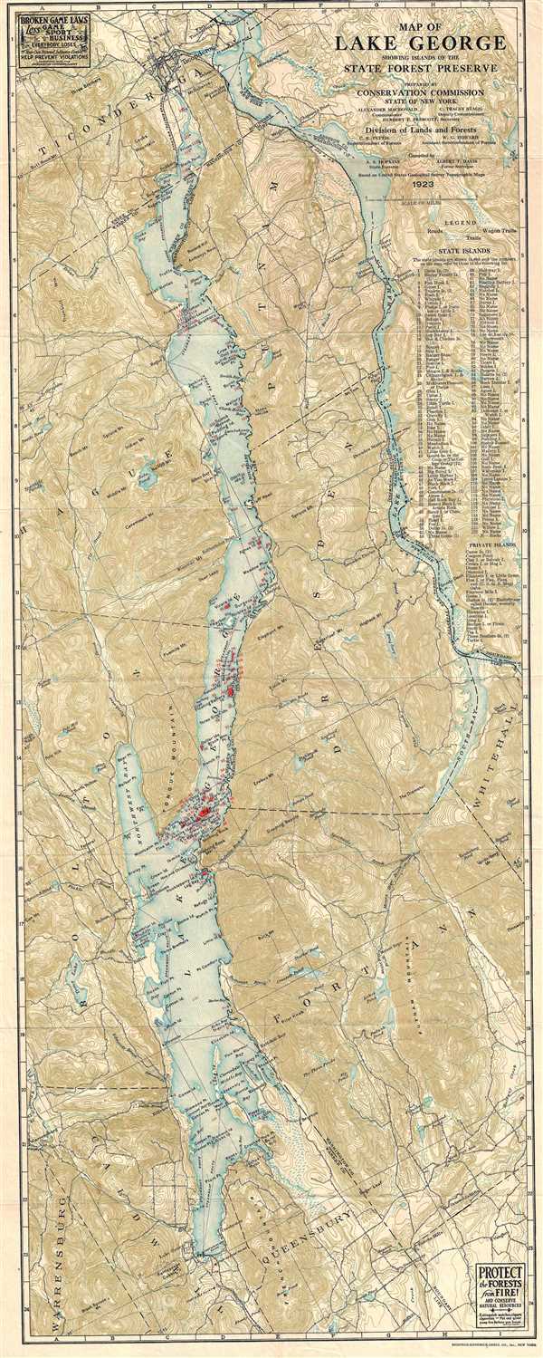
Map of Lake George Showing Islands of the State Forest Preserve
sold
- Digital Map Information
- Suitable for large format printing
- File Size: 18.05 MB
- File Type: ZIP / TIFF
- ICC color profile embedded
- Delivered instantly via download link
This is a 1923 Conservation Commission of the State of New York map of Lake George. The map depicts Lake George from the town of Lake George to Ticonderoga and from Bolton and Hague Counties to Dresden, ... (more details)