
Pictorial Colorado Springs!

Seeing Colorado Springs. The Gray Line.
sold
- Digital Map Information
- Suitable for large format printing
- Full resolution TIFF file
- ICC color profile embedded
- Delivered instantly via download link
This is a 1937 Fred Shantz pictorial tourist map of Colorado Springs, Colorado, and vicinity. Overlooking the city from the east, Cheyenne Mountain is on the left, Pike's Peak is in the center, and Woodland Park and Divide are on the right. Manitou Springs appears just below Pike's Peak and slightly to the right. Popular tourist sites are illustrated, including the Cheyenne Mountain Zoo, the Will Rogers Shrine of the Sun, Pike's Peak and the Pike's Peak Cog Railway, the Broadmoor Hotel, and the Cave of the Winds. Cheyenne Cañon, Seven Falls, and the Garden of the Gods appear as well. Colorado Springs residents will appreciate that Van Briggle Art Pottery is also labeled! Major streets throughout, such as Nevada Avenue, Tejon Street, Lake Avenue, and Cheyenne Boulevard, are marked by red lines. Cripple Creek, Victor, and the Royal Gorge (billed as the 'world's highest bridge') appear along the top border. Text along the bottom promotes Gray Line tours, including Pike's Peak by car, one of which will get a traveler to the top before sunrise. (more details)
Planned extension of the Florida Turnpike.

Map of Florida Showing Sunshine State Parkway and Other Principal Highways.
sold
This is a c. 1963 Florida State Turnpike Authority map of the Florida Turnpike. A thick red line highlights the Florida Turnpike from Miami north to Fort Prince. Squares with diamonds mark service stations and circles with lines mark interchanges. A red dashed line highlights the Wildwood Extension, which was scheduled to open on January 1, 1964. Thick black lines mark highways that had been completed or would be finished by January 1964 as of the publication of this map, while the thin black lines trace existing highways across the state. The black dotted line extending north from Fort Pierce along the Atlantic coast to Daytona Beach marks a section of highway not scheduled to be completed until at least December 1972. (more details)
Earliest Acquirable View of Charleston, South Carolina.
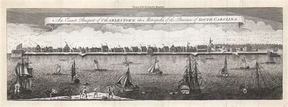
An Exact Prospect of Charlestown, the Metropolis of the Province of South Carolina.
sold
- Digital Map Information
- Suitable for large format printing
- Full resolution TIFF file
- ICC color profile embedded
- Delivered instantly via download link
This is the most important early view of Charleston, South Carolina. This view of Charleston was published in 1779 by the London Magazine. It is one of the few images available to the collector of the pre-Revolutionary colonial south, capturing the city when it was the fourth largest port in the North American British colonies. It is based on the unobtainable rare view of the same title engraved by William Henry Toms (c. 1700 - 1765) in 1739, in turn based on a watercolor painted from life by American artist Bishop Roberts between 1735 and 1739. (This original watercolor is in the collection of Colonial Williamsburg.) The view shows the waterfront of the city as seen from the opposite bank of the Cooper River. It clearly illustrates the town's shoreline batteries, warehouses, and wharves. Several structures are marked with a letter key: these are the Granville Bastion, the courthouse, the council chamber, the Quaker meeting house, the spire of Saint Philip's Church, the Customs House, and at the far-right Craven's Bastion. The waters of the Cooper are filled with ships, ranging from humble rowboats to British warships - underscoring both Charleston's prosperity and military significance. In the foreground, a group of fishermen wrestle a great fishnet ashore. The beautifully engraved sky above the city is teeming with birds. (more details)
Blessings and best wishes to America's soldiers and sailors fighting in Europe.

Over the Top with Uncle Sam.
sold
- Digital Map Information
- Suitable for large format printing
- File Size: 28.19 MB
- File Type: ZIP / TIFF
- ICC color profile embedded
- Delivered instantly via download link
This is a 1918 William Haskell World War I (1914 - 1918) pictorial propaganda broadside. A portrait of President Woodrow Wilson (1856 - 1924) with American flags and a bald eagle is the focal point. Portraits of General John J. Pershing (1860 - 1948), and Admiral William Sims (1858 - 1936) flank Wilson's portrait on the left and right, respectively. General Pershing commanded the American Expeditionary Force in Europe, while Admiral Sims commanded U.S. naval forces in Europe. Below the trio, illustrations of an Army soldier and his sweetheart, and a Navy sailor with his sweetheart, adorn the left and right. A poem by an unknown author entitled 'To the Boys in Khaki' sends the sweethearts' (and the country's) blessings and best wishes to the 'Soldier boy Somewhere in France'. A stirring image of an armed Uncle Sam striding 'over the top' (a phrase used to describe a World War I era charge out of a trench along the Western Front) across the Atlantic to Europe, where a German soldier cowers below his cape visually dominates the image. A fleet of American airplanes follows Uncle Sam across the Atlantic, bringing American firepower to bear against the enemy. (more details)
Early European mapping of the South China Sea.

A Carte Faite sur les Lieux part Daniel Tavernier in plusieurs Voiages qu il a fait au Tonquin.
sold
- Digital Map Information
- Suitable for large format printing
- Full resolution TIFF file
- ICC color profile embedded
- Delivered instantly via download link
A rare, important, and highly desirable 1682 map of modern-day Vietnam and the South China Sea by the French Huguenot merchant adventurer, Daniel Tavernier. The map covers the coast of Vietnam from southern China to the Mekong Delta. It includes parts of modern-day China, including the Island of Hainan, and the Chinese coast roughly as far north as modern-day Hong Kong and Macau. It includes the Island of Shangchuan (上川岛), just south of Hong Kong, where the Navarrese-Basque Roman Catholic missionary, St. Francis Xavier, died. (more details)
Ride the Union Pacific Railroad and Visit Sun Valley!
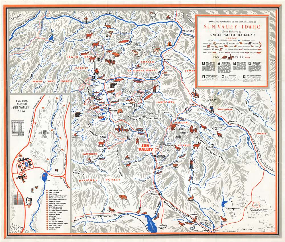
Panoramic Perspective of the Area Adjacent to Sun Valley, Idaho.
sold
- Digital Map Information
- Suitable for large format printing
- Full resolution TIFF file
- ICC color profile embedded
- Delivered instantly via download link
This is a c. 1938 William Willmarth pictorial map of Sun Valley, Idaho and environs issued to promote tourism. Pictorial icons highlight one of the region's iconic natural wonders: its wildlife. Bighorn sheep, elk, bears, bobcats, mountain goats, and mountain lions are represented. Mountains are labeled throughout, underscoring the area's fine alpine skiing. Sun Valley is situated below and to the right of center. A Union Pacific railroad spur leads to the resort, while red lines trace the highway network. An inset in the lower right details the Sun Valley Resort and alphabetically identifies twenty-four locations, including the Challenger Inn, the Sun Valley Lodge, the swimming pools, tennis courts, ice-skating rink, children's playground, golf course, and rodeo arena. (more details)
New York City at the center of the world.
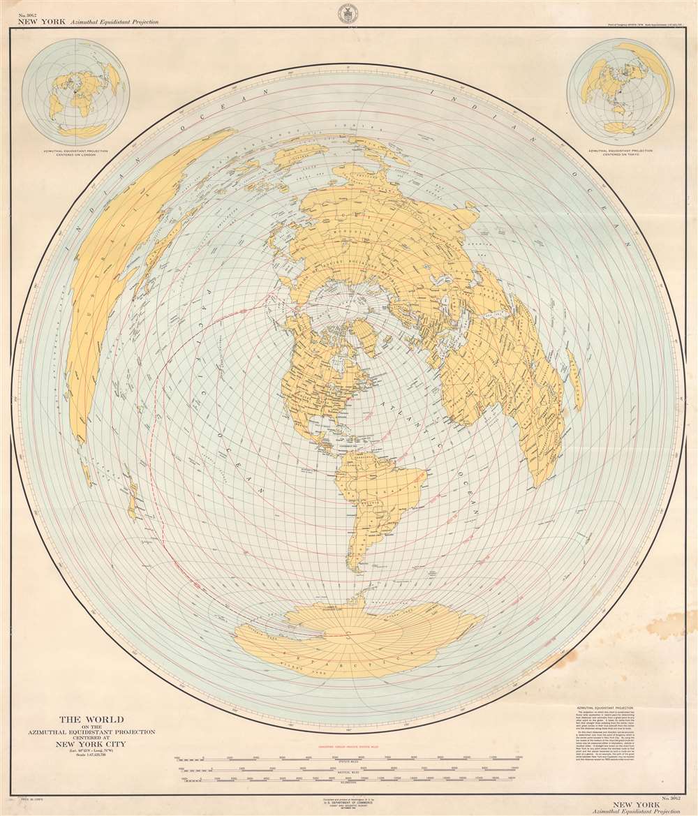
The World on the Azimuthal Equidistant Projection Centered at New York City.
sold
- Digital Map Information
- Suitable for large format printing
- File Size: 45.93 MB
- File Type: ZIP / TIFF
- ICC color profile embedded
- Delivered instantly via download link
This is a 1951 U.S. Coast and Geodetic Survey map of the world with New York City at its literal center. The map employs an azimuthal equidistant projection to accurately depict direct aviation 'great circle' routes from New York City to anywhere else in the world. Concentric red circles mark distances of 1,000 statute miles from New York City. The map provides an example of how this works, 'the path of the great circle between New York and Cape Town may be located and the distance scaled as 7,802 statute miles is correct'. Smaller maps situated in the upper left and right present the world using the same projection with different cities at the center: London and Tokyo. (more details)
Part of Channel Islands National Park.
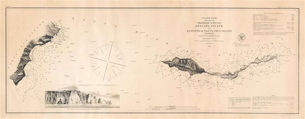
Preliminary Survey of Anacapa Island and East End of Santa Cruz Island California.
sold
- Digital Map Information
- Suitable for large format printing
- File Size: 9.12 MB
- File Type: ZIP / TIFF
- ICC color profile embedded
- Delivered instantly via download link
This is an 1856 U.S. Coast Survey nautical chart or maritime map of Anacapa Island and the eastern part of Santa Cruz Island, California. A view of one of the many sheer cliffs comprising the coastline of Anacapa Island is situated in the lower left quadrant. (more details)
One of the more attractive 19th century commercial atlas maps of Boston.

Plan of Boston.
sold
- Digital Map Information
- Suitable for large format printing
- File Size: 9.46 MB
- File Type: ZIP / TIFF
- ICC color profile embedded
- Delivered instantly via download link
This is an 1862 Samuel Augustus Mitchell, Jr. map of Boston, Massachusetts. The map depicts Boston along with parts of East Cambridge, Charlestown, East Boston, and South Boston. Parks, individual streets, trains, piers, ferries, and important buildings are all illustrated and labeled. An inset in the lower right depicts Boston Harbor and the greater Boston area. The whole is surrounded by the attractive floral border common to Mitchell atlases between 1860 and 1865. Mitchell's Boston is one of the more attractive atlas maps of the city to appear in the mid 19th century. (more details)
A beautiful pictorial map of Puerto Rico.
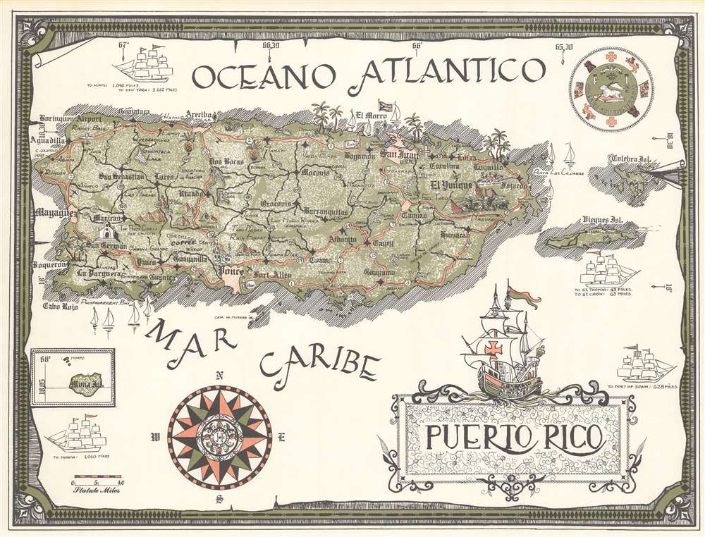
Puerto Rico.
sold
This is a c. 1970 pictorial map of Puerto Rico. Cities, towns, and villages across the island are identified, along with mountains and lakes. Pictorial vignettes highlight the Porta Coeli, an old church in San Germain, the old train near Fajardo, pineapple cultivation, and rum production. An arrow points out the location where Christopher Columbus landed in 1493. Illustrations of three-masted sailing ships underscore the vast distances to locations such as New York and Panama, as well as the relative proximity of St. Thomas and St. Croix. A wonderful illustration of a Spanish exploration vessel, perhaps one of Columbus's ships, adorns the title cartouche. (more details)
A souvenir of Bermuda.

Bermuda.
sold
This is a c. 1980 Rosemary Fernie pictorial map of Bermuda. Illustrations encircle the central map, which details Bermuda's road network, delineates and labels parishes, and identifies landmarks and tourist sites, including the island's six golf courses. Circular insets highlight Hamilton and St. George and even identify locations within each city. The illustrations surrounding express Bermuda's history and natural beauty. Sea birds, fish, and flowers appear alongside the Sea Venture (which wrecked off Bermuda in 1609 and may have inspired William Shakespeare's The Tempest), and mopeds. A pictorial border presents illustrations of tourist sites, activities, and Bermuda's culture and history. (more details)
Chromolithograph pre-construction view of the Statue of Liberty.

Liberty Enlightening the World. Edition Prepared Expressly for and Presented with the Compliments of Travelers Insurance Co. Hartford, this engraving represents the Clolooal Statue by Bartholdi, Presented by teh French People to America As it will appear on its pedestal on Bedloes Island in New York Harbor.
sold
- Digital Map Information
- Suitable for large format printing
- File Size: 41.4 MB
- File Type: ZIP / TIFF
- ICC color profile embedded
- Delivered instantly via download link
This exceptionally rare and stunning 4-color chromolithograph 1883 view of the Statue of Liberty is the most important pre-construction view of the statue and the first to receive official sanction. Issued 2 years prior to the Statue of Liberty's 1885 assembly and unveiling, this view illustrates the statue as seen from the south, looking north towards southern Manhattan and the Brooklyn Bridge, both of which are recognizable in the background. The image of the iconic statue here pre-dates the construction of the monument on Bedloe Island and is presented on one of Richard Morris Hunt's alternative plans rather than the base that was ultimately selected and constructed by the American Committee. (more details)
The Decline and Fall of the American Bison.
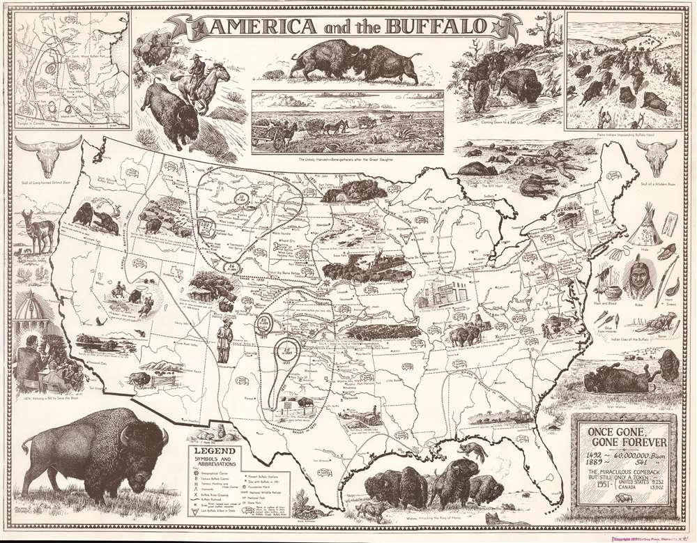
America and the Buffalo: Once Gone, Gone Forever.
sold
- Digital Map Information
- Suitable for large format printing
- File Size: 28.16 MB
- File Type: ZIP / TIFF
- ICC color profile embedded
- Delivered instantly via download link
This is a 1953 Michael H. Bevans pictorial map of the United States celebrating the American bison or buffalo. The map details the bison's historic range at varying dates, chronicling the near extinction and subsequent efforts dedicated to saving the species. A line of circles marks the bison's range as of 1500, stretching from the Atlantic Seaboard west to modern-day Oregon and Nevada. Other lines highlight the bison's precipitous decline in range and population following the arrival of Europeans. Bevans employs buffalo skulls to underscore decimated population and notes in each state the year the last bison was killed. (more details)
Comic look at 1980 Hong Kong.

Hong Kong.
sold
A 1980 charming pictorial map of Hong Kong by illustrator and Hong Kong historian Tom Briggs. The map looks east on Hong Kong, with Kowloon on the left and Hong Kong Island on the right. The Star Ferry appears just below and left of center, connecting Central to Kowloon Pier. The map is rife with advertising for Hong Kong businesses, but also historical notes, and humorous commentary. For example, a wizard advertised as a 'World Money Analyst' claims he can 'turn it into almost anything.' Fish in the harbor comment on Hong Kong social strata - 'They haven't spoken a word to anyone since they moved up to mid levels.' The pirate 'Eung Po Choi' claims that in 100 years he'll be a 'Hong Kong real estate developer.' Even the basement strip club, 'Bottoms Up' appears - duty free. (more details)
The Kennebec, St. George's, and Damariscotta Rivers.
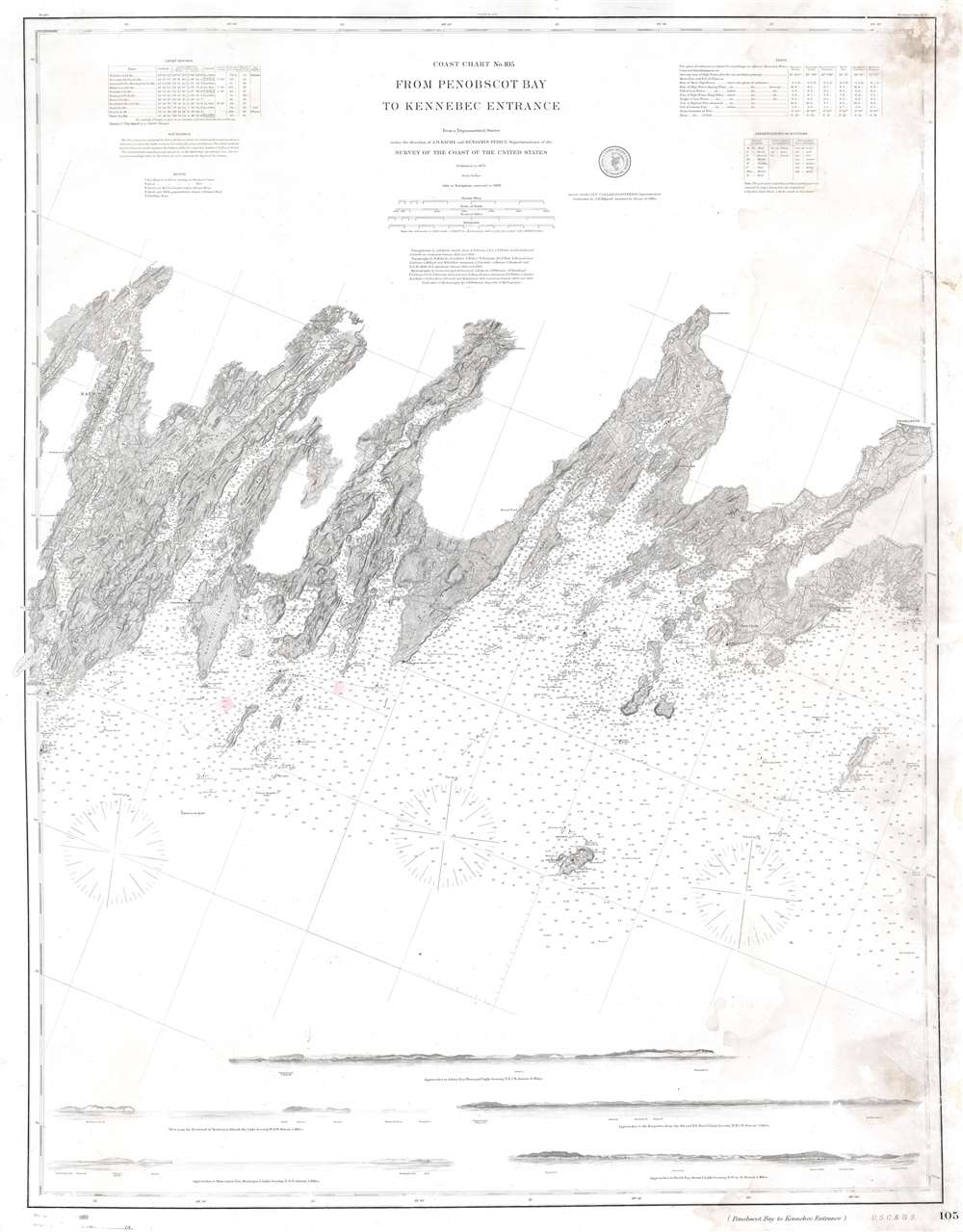
Coast Chart No. 105 From Penobscot Bay to Kennebec Entrance.
sold
- Digital Map Information
- Suitable for large format printing
- File Size: 32.1 MB
- File Type: ZIP / TIFF
- ICC color profile embedded
- Delivered instantly via download link
This is an 1888 United States Coast Survey nautical chart or maritime map of the central coast of Maine. Depicting from Merrymeeting Bay and the Kennebec River to Thomaston on the St. George's River, Maine's iconic coastline, with its bays, necks, islands, and other amazing features, becomes immediately apparent. Nearly all these islands are identified by name, along with the many rivers, coves, bays, and, of course, coastal cities. Among these are Bath, Wiscasset, Newcastle, Damariscotta, and Waldoboro. Numerous buildings (illustrated by small black squares) line the region's roads. Coastal lights, buoys, and other navigation aids are indicated as well. Five coastal views are included along the bottom of the map and are meant to help mariners identify their location while traveling this stretch of coast. (more details)
Complex projection mapping the Mediterranean Islands.
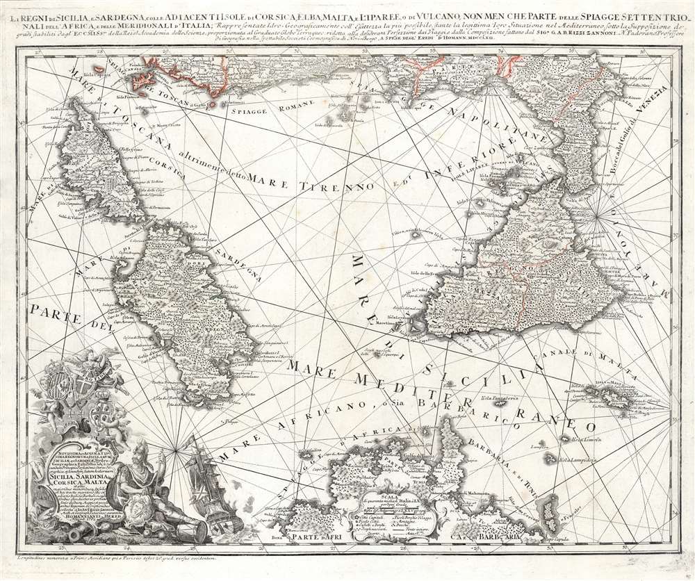
Li Regni di Sicilia e Sardegna colle Adiacenti Isole di Corsica, Elba, Malta e Liparee, o di Vulcano, non men che parte delle spiagge settentrionali dell'Africa e delle Meridionali d'Italia, Rappresentate Idro- Geograficamente e all'esattezza la più possibile, stante la legittima loro Situazione nel Mediterraneo sotto la Supposizione dei grandi stabiliti dagl'Eccmiss.mi della Reial Accademia delle Scienze, proporzionata al Graduato Globo Terraqueo: ridotta alla desiderata Perfezione dai Viaggi e dalla composizione fattane dal Sig. e G.A.B. Rizzi Zannoni N. Padovano Professore di Geografia nella spettabile Società Cosmografica di Norimbergo, A spese degl' Eredi d'Homann MDCCLXII.
sold
- Digital Map Information
- Suitable for large format printing
- Full resolution TIFF file
- ICC color profile embedded
- Delivered instantly via download link
This superbly detailed map, engraved by Homann Heirs in 1762 based on the work of Giovanni Antonio Bartolomeo Rizzi-Zannoni, is among the finest and most appealing maps of Corsica, Sicily and Sardinia. The map encompasses the Mediterranean from Corsica to Malta and the Gulf of Venice, and from the west coast of Italy to the Tunisian coast of Africa. The map's complex stereographic projection allows the presentation of the three main islands of the map to be presented as if on a plane, while necessarily distorting the areas at the edge of the map; it is also generally oriented to the northeast, resulting in the unusual and symmetrical presentation of the region. The map is significantly more complex and detailed than previous Homann or Homann Heirs maps; this is due to the work of the Italian cartographer Rizzi-Zannoni, who in 1757 had traveled to Germany to enter the service of Prussia during the Seven Years' War. (more details)
The Potomac River during the American Civil War.
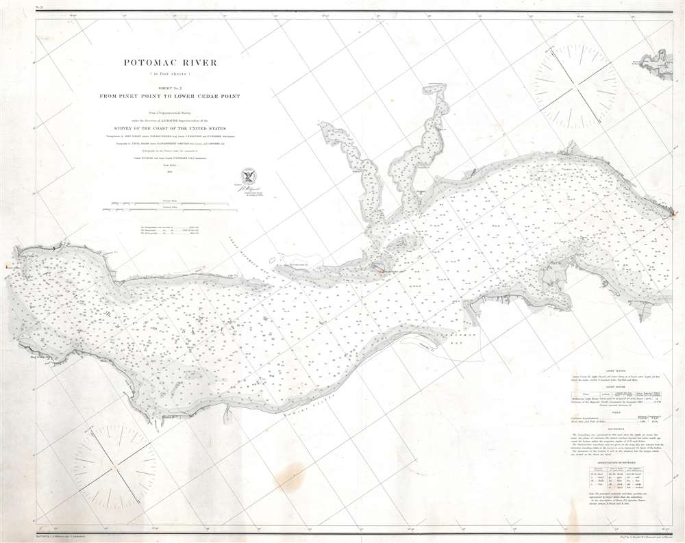
Potomac River (in four sheets) Sheet No. 2 From Piney Point to Lower Cedar Point.
$500.00
Acquire
- Digital Map Information
- Suitable for large format printing
- File Size: 21.56 MB
- File Type: ZIP / TIFF
- ICC color profile embedded
- Delivered instantly via download link
This is an 1862 U.S. Coast Survey nautical chart or maritime map of part of the Potomac River. Separating Maryland and Virginia, the map depicts from Lower Cedar Point to Piney Point. Depth soundings are indicated throughout, including in St. Clement's Bay and Breton's Bay. Points and other coastal features, including the Nomini Cliffs, are labeled. Navigational aids, such as buoys and lights, are illustrated and labeled, along with navigational hazards, including shoals and islands. (more details)
The Red Guard in the Cultural Revolution.

世界革命的中心一北京. [Beijing, the Center of the World Revolution]. / 北京市城区街道图. [Street Map of Beijing].
$500.00
Acquire
This is a 1967 Workers' Congress city plan or map of Beijing, China published at the height the Cultural Revolution. Black text labels streets while red text identifies buildings and landmarks, including the National Stadium, the Palace Museum, the National Assembly Hall, and Beijing Station. A list directly above the map provides the new street names next to the old ones (renaming streets was part of the Cultural Revolution), and a text above the map exhorts the Red Guards to action. A quote from Mao in the upper left (next to his portrait) states, 'You must be concerned about major national affairs and carry out the Great Proletarian Cultural Revolution to the end!' (more details)
Tel Aviv during the era of British Mandate Palestine.
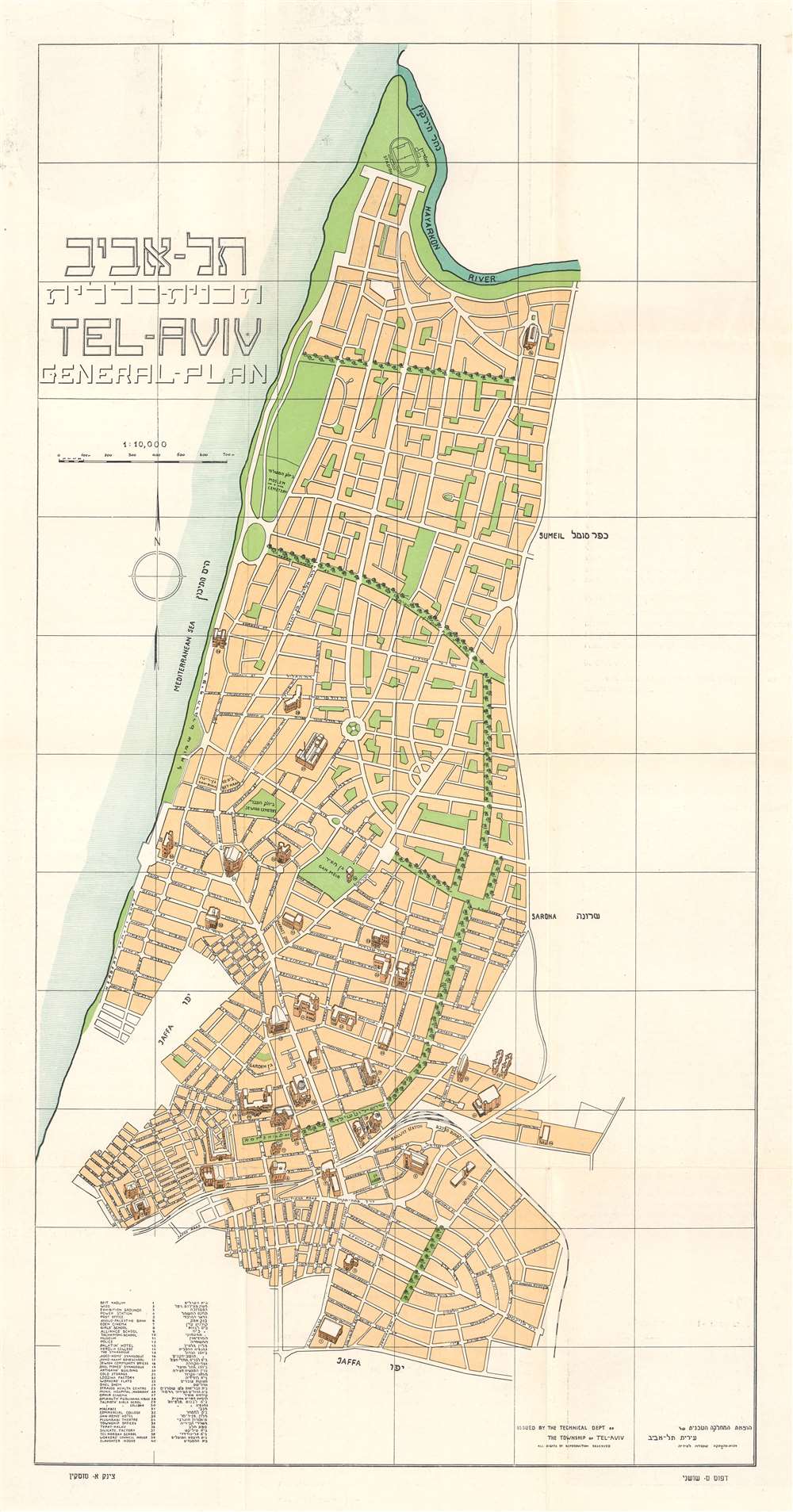
.תל - אביב תכנית -- כללית / Tel-Aviv General-Plan.
sold
- Digital Map Information
- Suitable for large format printing
- Full resolution TIFF file
- ICC color profile embedded
- Delivered instantly via download link
This is a c. 1932 Technical Department of the Township of Tel-Aviv bilingual English and Hebrew city plan or map of Tel Aviv. Published during the era of British Mandatory Palestine, the map depicts the city from the Hayarkon River to Jaffa. Major streets in the center of town are labeled in both English and Hebrew. The city's green spaces stand out to the viewer. Two of these spaces are identified as cemeteries: one Jewish and one Muslim. Thirty-eight locations, drawn in the monumental pictorial style, appear throughout the city and are numerically labeled. These numbers correspond with an index situated in the lower left corner. (more details)
One of the most detailed early maps to focus on the Mississippi Delta.
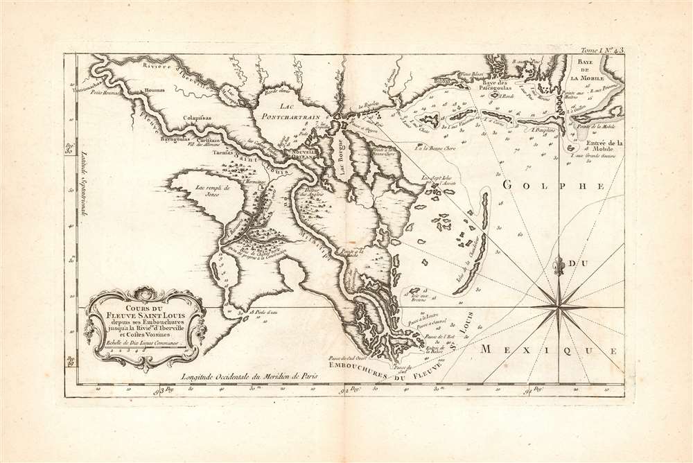
Cours du fleuve Saint Louis depuis ses embouchures jusqu'à la rivière d'Iberville et costes voisines.
sold
- Digital Map Information
- Suitable for large format printing
- Full resolution TIFF file
- ICC color profile embedded
- Delivered instantly via download link
This is a 1764 Jacques-Nicolas Bellin map of the Gulf Coast of Louisiana, Mississippi, and part of Alabama. The map's western extent includes the juncture of the Mississippi and the 'Rivier d'Iberville' (actually the Bayou Manchac) and an unnamed lake (possibly Lake Salvador.) The northern reaches of the map include the Rivier d'Iberville, Lake Maurepas, Lake Pontchartrain, and the Gulf coast as far as Mobile Bay. The central focus of the map is the lower Mississippi River and its complicated delta. The city of New Orleans is prominently noted. The region's labyrinthine coastline is heavily notated with depth soundings and the names of many smaller islands; key features are noted as well, such as the large shallow lake which is said to have been 'filled by Jones,' and a 'green oak wood said to be suitable for construction.' Upriver from New Orleans appears a settlement called Carlstain Vill. des Allemans: this was a remnant of the disastrous German settlement of the Mississippi under the aegis of John Law's infamous Company of the West.
The Mississippi is referred to here as the River of Saint Louis, a terminology introduced in French maps in the early 18th century - possibly initially by Guillaume De l'Isle in his 1718 Carte de la Louisiane although the name does not appear in that mapmaker's 1703 Carte du Mexique et de la Floride. (more details)
The Mississippi is referred to here as the River of Saint Louis, a terminology introduced in French maps in the early 18th century - possibly initially by Guillaume De l'Isle in his 1718 Carte de la Louisiane although the name does not appear in that mapmaker's 1703 Carte du Mexique et de la Floride. (more details)