
German mapping of the Republic of Texas.

Texas.
sold
- Digital Map Information
- Suitable for large format printing
- Full resolution TIFF file
- ICC color profile embedded
- Delivered instantly via download link
This is a c. 1846 Carl Flemming map of Texas shortly after the Republic of Texas was annexed into the United States (1845). Based on John Arrowsmith's map, Flemming identifies thirty counties in eastern and southeastern Texas, labels them numerically, and provides the county names in a table in the upper right. Numerous settlements are noted along the Rio Grande River in what is today New Mexico. An inset of Galveston Bay is situated in the lower left corner. Flemming also includes an erroneous annotations originally printed on the Arrowsmith map regarding the arid region of western Texas, 'This tract of Country explored by Le Grande in 1833 is naturally fertile, well wooded, and with a fair proportion of water.' (more details)
Predicts a Solar Eclipse and reveals Arctic Explorations.

The geography of the great solar eclipse of July 14 MDCCXLVIII. : exhibiting an accurate map of all parts of the Earth in which it will be visible with the North Pole according to the latest discoveries.
sold
- Digital Map Information
- Suitable for large format printing
- Full resolution TIFF file
- ICC color profile embedded
- Delivered instantly via download link
This elegant, 1748 north polar projection map was drawn by the English astronomer and writer George Smith and engraved by the great English mapmaker Thomas Jefferys. It was produced for inclusion in Smith's pamphlet describing and predicting the path of the July 14, 1748, solar eclipse. Twenty-four diagrams show the expected appearance of the eclipsed sun as viewed from different cities, and the map's notation shows both the areas from which partial or full eclipses might be seen. The map's polar projection is presented obliquely to show all the parts of the known world from which the eclipse would be visible. As a result, Smith and Jefferys provide a snapshot of the general state-of-the-art of geographical knowledge of the northernmost parts of the globe to be reached by Europeans, during a period in which the English were active in their attempts to navigate those waters. (more details)
Named by George Vancouver after his ship the Discovery.

Port Discovery and Washington Harbor Washington.
sold
- Digital Map Information
- Suitable for large format printing
- Full resolution TIFF file
- ICC color profile embedded
- Delivered instantly via download link
This is an 1890 U.S. Coast and Geodetic Survey nautical chart or maritime map of Discovery Bay, Washington. On the south side of the Strait of Juan de Fuca on Washington's Olympic Peninsula, here the bay is identified by its historical name, Port Discovery. Both Discovery Bay and Washington Harbor are illustrated in detail. Numerous depth soundings (in fathoms) provide a clear picture for mariners, and points along the coastline are labeled. Protection Island sits in the Strait of Juan de Fuca. (more details)
An intriguing and unusual map of the southwestern United States.
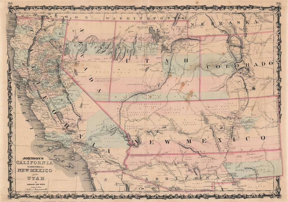
Johnson's California. Territories of New Mexico and Utah.
sold
- Digital Map Information
- Suitable for large format printing
- File Size: 25.57 MB
- File Type: ZIP / TIFF
- ICC color profile embedded
- Delivered instantly via download link
This is an 1863 A. J. Johnson map of California, Nevada, Utah, New Mexico, Arizona, and Colorado. Filled with amazing historical detail, the map presents an unusual configuration of these western states. (more details)
A rare railroad map of Florida and the beginning of the Plant System of railroads.

Map of the Savannah, Florida, and Western Railway.
sold
- Digital Map Information
- Suitable for large format printing
- File Size: 10.47 MB
- File Type: ZIP / TIFF
- ICC color profile embedded
- Delivered instantly via download link
This is an 1882 Rand Avery railroad map of Florida and Georgia. Depicting the region from Savannah to Lake Okeechobee and from St. Andrews Bay to the Atlantic Ocean, thick red lines highlight the Savannah, Florida, and Western Railway. Thinner red lines trace the routes of connecting railways, including the Brunswick and Albany Railroad; the Jacksonville, Pensacola, and Mobile Florida Central Railroad; and the Florida Transit Railroad. Two short railroads are illustrated and labeled in central Florida, one of which is identified at the Southern Florida Railroad. (more details)
Sailing Map of Western Long Island Sound's Sailing Grounds by a Sail Lover.
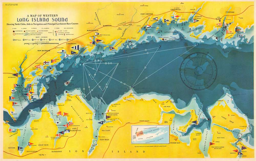
A Map of Western Long Island Sound: Showing Yacht Clubs, Aids to Navigation and Principal Larchmont Race Courses.
sold
- Digital Map Information
- Suitable for large format printing
- Full resolution TIFF file
- ICC color profile embedded
- Delivered instantly via download link
This is a delightful 1939 Rolf Klep pictorial map of western Long Island Sound. It covers the waters off Westchester County, Fairfield County, and the ‘Gold Coast’ of Long Island, specifically those frequented by the members of the Larchmont Yacht Club. A note on the verso describes this as ‘a Yachting Paradise’ and ‘the most populous yachting center in the world, with about fifty clubs lining some seventeen miles of Long Island Sound.’ The locations of indeed fifty yachting clubs are marked with flags on the map, as are lighthouses, buoys, and radio beacons. The routes of seven Larchmont Regatta race courses are shown in white overlapping triangles throughout the Sound. Though soundings are not numbered, depths are indicated by varying shades, the darkest showing the deepest water, over 120 feet. Ebb and flood tides are marked on the map with arrows, as are key landmarks used by yachtsmen to take compass bearings - chimneys, domes, water towers and even specific houses. Despite the map’s richness of detail, the author of the article it accompanied was at pains to explain that ‘though accurate, this map should not be used for navigation’ directing the reader instead to consult the U.S. Coast and Geodetic Survey and Texaco cruising charts from which the map’s data was drawn. (more details)
One of the rarest and most important first-hand illustrations of Perry's meeting with Tokugawa Japan - here in a spectacular Elephant Folio.

Passing the Rubicon. Lieut. S. Bent in the 'Mississippi's' First Cutter forcing his way through a fleet of Japanese boats while surveying the Bay of Yedo, Japan, July 11th, 1853.
sold
- Digital Map Information
- Suitable for large format printing
- File Size: 42.21 MB
- File Type: ZIP / TIFF
- ICC color profile embedded
- Delivered instantly via download link
A rare and important 1855 Eliphalet Brown and Wilhelm Heine hand-tinted elephant-folio lithograph view of one of the most significant and impactful moment in history - the meeting of East and West, when an American Naval Squadron under Commodore Matthew C. Perry sailed into Edo Harbor and forced Tokugawa Japan to accept foreign embassies and trade, ending 214 years of self-imposed Sakoku (鎖国, 'Closed-Country') isolation. Part of a rare and significant elephant folio set representing a 'holy grail' item for Perry collectors. (more details)
A rare map of Mount Desert Island published during the Great Depression.
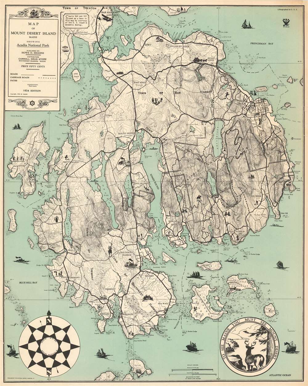
Map of Mount Desert Island Maine Showing Acadia National Park.
sold
- Digital Map Information
- Suitable for large format printing
- File Size: 40.24 MB
- File Type: ZIP / TIFF
- ICC color profile embedded
- Delivered instantly via download link
This is a 1934 Howe D. Higgins map of Mount Desert Island, Maine. Depicting the island in its entirety, Higgins employed two U.S. Coast and Geodetic Survey charts to create the base map and then added the delightful vignettes and a different typeface. Thick black lines trace the island's road network, while dashed lines highlight its famed carriage roads. Depth soundings appear along the coasts, particularly in the coves and harbors. (more details)
Features colorful illustrations of Bangkok and other major cities.

Charming Thailand.
sold
- Digital Map Information
- Suitable for large format printing
- File Size: 35.75 MB
- File Type: ZIP / TIFF
- ICC color profile embedded
- Delivered instantly via download link
This is a c. 1950 Thai Bureau of Tourist Promotion pictorial tourist map of Thailand. Created using brilliant colors, pictorial icons highlight many of Thailand's cities using famous buildings or sites. Some of these include the Temple of the Emerald Buddha (Wat Phra Kaew, Bangkok), Wat Phra That Doi Suthep (Chiang Mai), and Phra Pathom Chedi (Nakhon Pathom). Elephants, cobras, cattle, cotton, and salt present exotic elements. Airplanes emphasize the interconnected reality of the air age and suggest easy access to Thailand. An inset on the lower right situates Thailand on the Asian continent, allowing English-speaking tourists who may not be familiar with the country some understanding of the country's geography. (more details)
Beautiful chromolithograph map of the world in hemispheres.

[Western Hemisphere]. [Eastern Hemisphere].
sold
- Digital Map Information
- Suitable for large format printing
- File Size: 13.6 MB
- File Type: ZIP / TIFF
- ICC color profile embedded
- Delivered instantly via download link
This is a c. 1885 James Monteith map of the world in hemispheres. Printed on two sheets, captions under both hemispheres state that they were 'photographed from a globe.' Each hemisphere appears on its own sheet and, and major mountain ranges, lakes, and rivers are visible. Ethnographic pictorial borders, complete with stereotypical views, adorn both sheets. Portraits of a North American Indian, and Esquimaux, a Sandwich Islander, and a South American Indian surround the Western Hemisphere, and purportedly depict these peoples in characteristic scenes. The North American Indian, sitting in front of their tepee, is accompanied by a sketch of an American bison. At the same time, a polar bear on sea ice overlooks the Esquimaux standing in front of their igloo. The portraits of the Sandwich Islander and the South American Indian focus on the tropical vegetation of their native lands. Portraits of a Caucasian, a Mongol, a Malay, and an Ethiopian surround the Eastern Hemisphere. A European thoroughfare accompanies the Caucasian, while the same sort of view of an Asian city acts as the backdrop for the Mongol. Landscapes, much like those on the Western Hemisphere sheet, are presented with the Malay and the Ethiopian and depict these people in purportedly natural settings. (more details)
Incredible pictorial map recounting Montana's frontier history.

Montana. Frontier. Pioneer.
sold
- Digital Map Information
- Suitable for large format printing
- Full resolution TIFF file
- ICC color profile embedded
- Delivered instantly via download link
This is a 1937 Irvin Shope pictorial map of Montana. The map depicts the state from Idaho to the Dakotas and from Canada to Wyoming, including Yellowstone National Park. Highly detailed, myriad captions, vignettes, and other illustrations populate the map, creating a visual representation of Montana's history. Most of the captions recount tales of the Wild West, outlaws, vigilantes, and frontier violence and 'justice' abound. Others inform the viewer of more conventional milestones, such as the location of the first Territorial Legislature or that Virginia City was the first capital of the Montana Territory. Numerous cities and towns of all sizes are labeled, including Helena, Missoula, and Bozeman. Vignettes frame the map, illustrating 'the major frontier industries: trapping, mining, cattle and sheep raising, and lumbering'. A legend along the bottom border explains the various notations utilized on the map. (more details)
Identifies Kabul, Kandahar, Lahor, and Delhi.
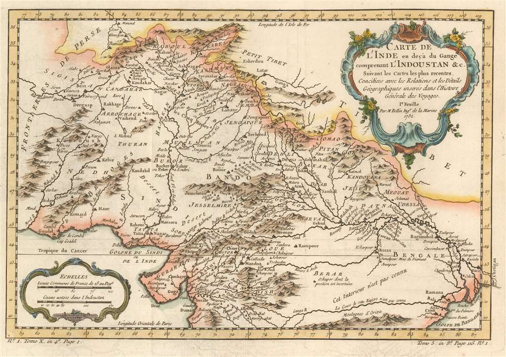
Carte de L'Inde en deçà du Gange comprenant l'Indoustan etc. Suivant les cartes les plus recentes.
sold
- Digital Map Information
- Suitable for large format printing
- DPI: 600
- File Size: 6.95 MB
- File Type: ZIP / TIFF
- ICC color profile embedded
- Delivered instantly via download link
This is a 1780 Jacques-Nicolas Bellin map of northern India, Afghanistan, and Pakistan. Depicting the region from the Persian frontier to the mouth of the Ganges River, myriad cities, towns, and villages appear on this gorgeously detailed piece, with Kabul, Kandahar, Lahore, and Delhi among them. The area's extensive river system is detailed, and both the Indus and Ganges rivers are labeled. Kashmir, the territory continually in dispute between Pakistan and India today, is also marked. (more details)
Traces part of Gmelin's expedition across Siberia to join Vitus Bering.
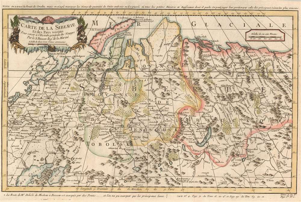
Carte de la Siberie et des Pays voisins.
$200.00
Acquire
- Digital Map Information
- Suitable for large format printing
- DPI: 600
- File Size: 12.08 MB
- File Type: ZIP / TIFF
- ICC color profile embedded
- Delivered instantly via download link
This is a 1780 Jacques-Nicolas Bellin map of Siberia. Depicting the region from Moscow and St. Petersburg to central Asia, numerous cities, towns, and villages are labeled. The region's rivers are illustrated in detail, along with its many mountain ranges. (more details)
An educational and entertaining pictorial map of Casco Bay.

An Historical and Pictorial Map of Casco Bay Maine.
sold
- Digital Map Information
- Suitable for large format printing
- File Size: 24.23 MB
- File Type: ZIP / TIFF
- ICC color profile embedded
- Delivered instantly via download link
This is a charming c. 1950 pictorial and historical map of Casco Bay, Maine by Edward Rowe Snow and Draper Hill, Jr. It covers Casco Bay, an inlet of the Gulf of Maine on the southern coast of Maine, from Prouts Neck (Scarborough Beach State Park) east as far as the southern portion of Georgetown Island, including the city of Portland. Throughout, the map notes towns, islands, capes, points and a few other topographical features. (more details)
Meant to 'aid your exploration of the Village'.
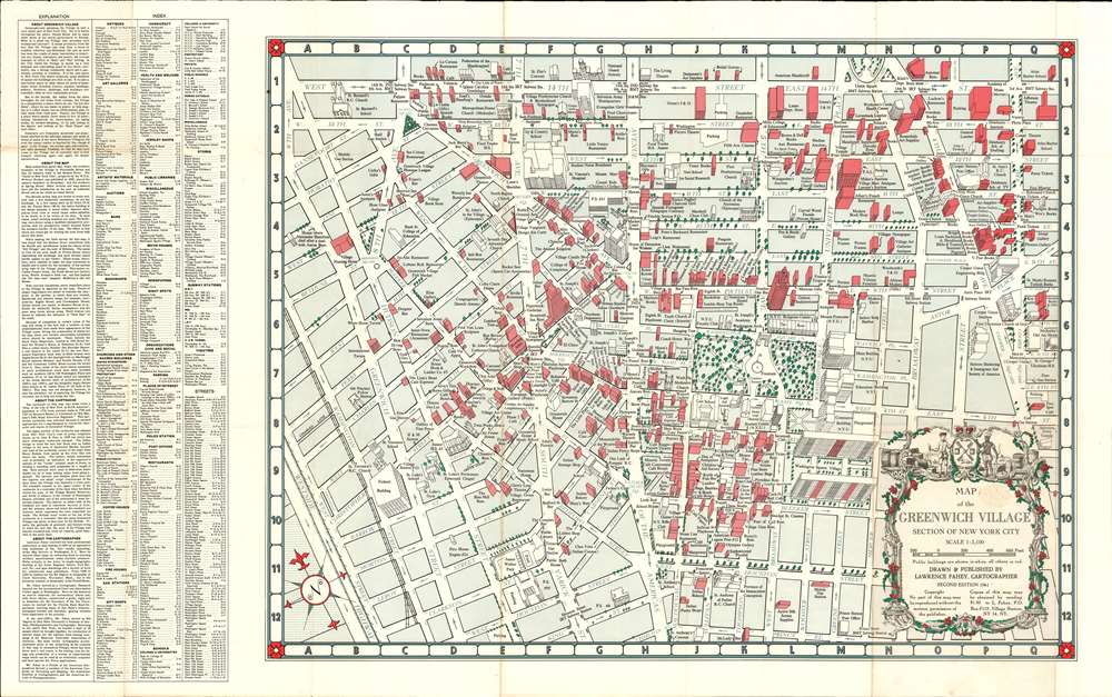
Map of Greenwich Village. Section of New York City.
sold
This is a 1961 Lawrence Fahey pictorial city plan or map of Greenwich Village in New York City. Depicting the neighborhood from 9th Avenue and Gansevoort Street to 3rd Avenue and from 14th Street to Prince Street, Fahey uses a 'modified perspective projection' to draw the buildings, nearly all of which are drawn to scale. In some cases, when the building would have obscured others, or its size would have caused undue attention, Fahey elected not to illustrate the entire building. The map labels antique shops, bars, theaters, bookshops, schools, and restaurants, among other businesses. Washington Square Park and New York University appear to the right of center, and the law school, education buildings, and the Maison Francaise are among the buildings labeled. It is worth noting that the cartouche was borrowed from Bernard Ratzer's celebrated 'Plan of the City of New York in North America' published in 1776. (more details)
The highest overall percentage of casualties of any American Civil War battle.

Battle of Stone River. Near Murfreesborough, Tenn.
sold
- Digital Map Information
- Suitable for large format printing
- File Size: 53.11 MB
- File Type: ZIP / TIFF
- ICC color profile embedded
- Delivered instantly via download link
This is an 1891 Kurz and Allison chromolithograph view of the American Civil War Battle of Stones River. Kurz and Allison present a stylized view of the battle, with Union Major General Rosecrans in the foreground on the left. With Union troops on the left and Confederate soldiers are on the right, Kurz and Allison correctly depict the fighting on both sides of the Stones River. The several cannons on the Union side likely allude to the critical role of Union artillery in repulsing two Confederate attacks on January 2. The field is littered with casualties, a reference to the battle's high human cost. (more details)
Extremely colorful pictorial map of the Hawaiian Islands by illustrator Joseph Feher.

The Dole Map of the Hawaiian Islands.
sold
- Digital Map Information
- Suitable for large format printing
- File Size: 48.58 MB
- File Type: ZIP / TIFF
- ICC color profile embedded
- Delivered instantly via download link
This is a 1950 Joseph Feher pictorial map of the Hawaiian Islands. The map depicts all eight of the major islands in the archipelago from Nihau and Kauai to Hawaii. Myriad illustrations populate the map, with each island's uniqueness coming through thanks to these illustrations. Vignettes celebrating Hawaiian daily life, culture, and history are present, as are sailing ships from every era and even an airliner. Numerous tropical fish surround the archipelago, including a humuhumunukunukuapua'a and a butterfly fish, along with an octopus and a moray eel. An index to the right of the map details most of these illustrations, although a few are left out. (more details)
Cartographically delivering the news of the Great Fire of Boston.

Bird's-Eye View of Boston, Showing the Burned District.
sold
- Digital Map Information
- Suitable for large format printing
- File Size: 30.81 MB
- File Type: ZIP / TIFF
- ICC color profile embedded
- Delivered instantly via download link
A dramatic 1872 view of Boston illustrating the extent of the devastation caused by the Great Boston Fire of November 7-8, 1872. Issued just three weeks later, this is one of the first depictions of the fire. In order to satisfy the immediate demand for information about the disaster, Harper's Weekly turned to Currier and Ives, who had already contracted illustrator Charles R. Parsons to collect material to produce a grand view of the city. Parsons - already employed as head of Harper's art department - was in a unique position and consolidated the resources of both firms to swiftly produce this timely view. It therefore predates the famous grand format Currier and Ives The City Of Boston by a year. (more details)
Published during the World War II Philippine Campaign.

Philippine Islands. Manila Bay and Approaches.
sold
- Digital Map Information
- Suitable for large format printing
- File Size: 73.13 MB
- File Type: ZIP / TIFF
- ICC color profile embedded
- Delivered instantly via download link
This is a 1944 U.S. Coast and Geodetic Survey nautical chart or maritime map of Manila Bay in the Philippines. Likely published for MacArthur's 1945 campaign on Luzon, a red stamp along the bottom border dated April 1945 from the Hydrographic Office of the Navy Department suggests that this map played some role in the Philippine Campaign. The map depicts the region's coastal areas in detail, with river mouths, settlements, and roads among the highlighted features. The Bataan Peninsula's topography is also illustrated, as are some settlements and roads further inland from Manila itself. Myriad depth soundings populate the bay, allowing for much more confident navigation. Corregidor Island, where MacArthur sheltered during the Japanese invasion of 1941-42, sits at the mouth of Manila Bay and is depicted in detail. Red manuscript notations mark three beacons that were relit by the Americans after liberating the area from the Japanese. (more details)
A rare map of Maine published for canoeists!
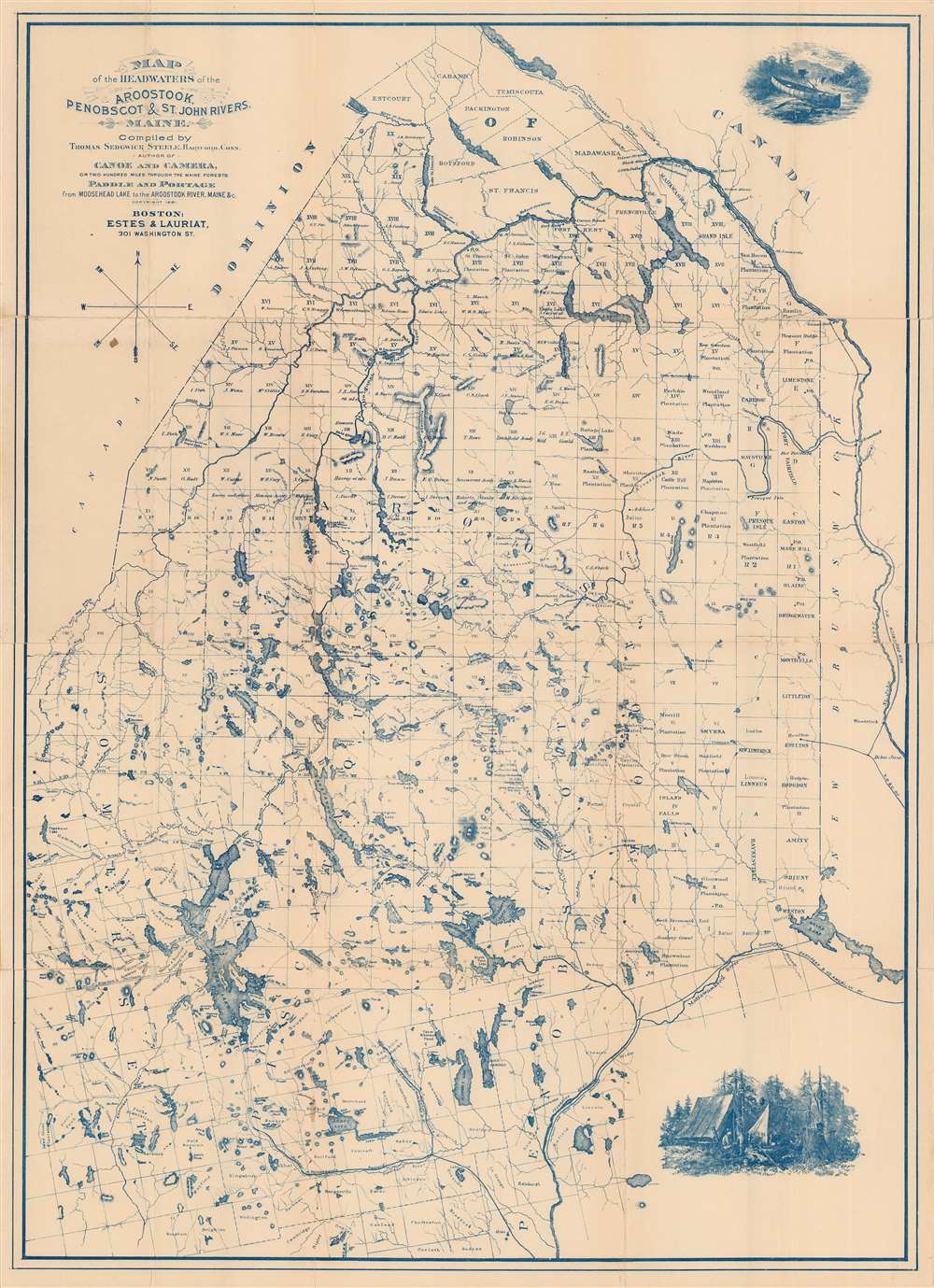
Map of the Headwaters of the Aroostook, Penobscot, and St. John Rivers, Maine.
sold
- Digital Map Information
- Suitable for large format printing
- File Size: 29.86 MB
- File Type: ZIP / TIFF
- ICC color profile embedded
- Delivered instantly via download link
This is an 1881 Thomas Sedgwick Steele map of central and eastern Maine. Depicting the state from Penobscot Lake to Grand Lake, this is one of the first maps ever issued with the canoeist in mind. The Aroostook, Penobscot, and St. John rivers appear in fantastic detail, alongside Maine's extensive lake and river system. Moosehead Lake, Maine's largest lake, is situated on the left side. Maine's township grid overlays the state. Township owners are identified, and several towns close to the Canadian border, such as Linneus and Houlton, are labeled as well. The Female Seminary Grant is marked, as is the Middlesex Canal Grant, the Day's Academy Grant, and the Sandwick Academy Grant, among others. Entirely printed with blue ink, the map features two attractive engravings, one of Steele's canoe at the top right and another of his camp at the bottom right. Both of which are based on Steele's paintings. (more details)