
Coast Survey chart of Ponce de Leon Inlet in Florida - formerly known as Mosquito Inlet.
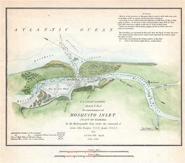
Sketch F. No. 3 Reconnoissance of Mosquito Inlet Coast of Florida.
sold
- Digital Map Information
- Suitable for large format printing
- DPI: 300
- File Size: 1.19 MB
- File Type: ZIP / TIFF
- ICC color profile embedded
- Delivered instantly via download link
This is a beautiful example of the 1851 U.S. Coast Survey chart of the Mosquito Bay or Ponce de Leon, Florida. It depicts the Ponce de Leon Inlet, a natural opening in central Florida connecting the south end of the Halifax River and the northern end of Mosquito ... (more details)
Beautiful nautical chart detailing part of the San Francisco Bay Area.

Sketch J No. 2 Mare Island Strait California.
sold
- Digital Map Information
- Suitable for large format printing
- DPI: 300
- File Size: 1.99 MB
- File Type: ZIP / TIFF
- ICC color profile embedded
- Delivered instantly via download link
This is a lovely example of the 1851 U.S. Coast Survey nautical chart or maritime map of the Mare Island Straits, California. The map depicts part of the San Francisco Bay area including Mare Island, Straits of Karquines and parts of Vallejo. Vallejo, which ... (more details)
Two months before the Allied victory in North Africa, thoughts of invading Europe are still on everyone's mind.
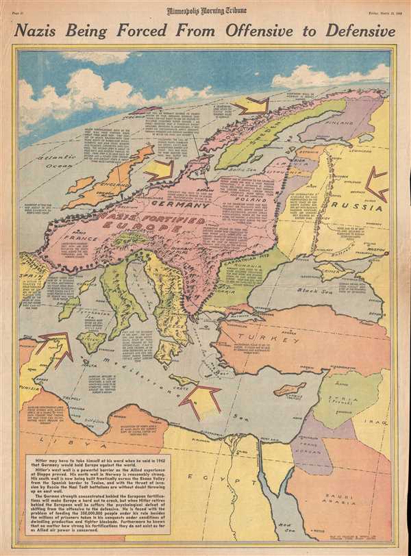
Nazis Being Forced From Offensive to Defensive.
sold
- Digital Map Information
- Suitable for large format printing
- File Size: 11.01 MB
- File Type: ZIP / TIFF
- ICC color profile embedded
- Delivered instantly via download link
This is a Friday, March 19, 1943 Charles Hamilton Owens and Minneapolis Morning Tribune map of 'Fortress Europe'. The map depicts the region from Spain and Algeria to Scandinavia, Russia, Turkey, and the Middle East and from the Arctic Ocean to North ... (more details)
Details the presumed Allied invasion of the Balkans - printed one day before the actual invasion of Sicily.
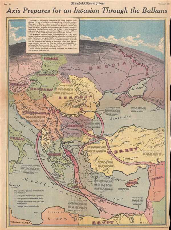
Axis Prepares for an Invasion Through the Balkans.
sold
- Digital Map Information
- Suitable for large format printing
- File Size: 14.08 MB
- File Type: ZIP / TIFF
- ICC color profile embedded
- Delivered instantly via download link
This is a Friday, July 9, 1943 Charles Hamilton Owens and Minneapolis Morning Tribune map of the Balkans and Eastern Europe. The map depicts the region from Italy, Malta, and Libya to Russia, Turkey, and the Middle East and from Russia, Poland, and ... (more details)
Provides an incredible visual summary of combat on the Eastern Front through the beginning of May 1943.
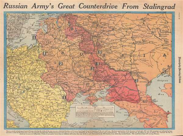
Russian Army's Great Counterdrive from Stalingrad.
sold
- Digital Map Information
- Suitable for large format printing
- File Size: 11.97 MB
- File Type: ZIP / TIFF
- ICC color profile embedded
- Delivered instantly via download link
This is a Wednesday, March 3, 1943 William H. Wisner and Minneapolis Morning Tribune map of the Eastern Front during World War II. The map depicts the region from Copenhagen, Berlin, Prague, and the Adriatic Sea to the Ural Mining and Industrial ... (more details)
Illustrates the rail line constructed by the colonial British in modern-day Zimbabwe in the hopes of exporting large quantities of gold.
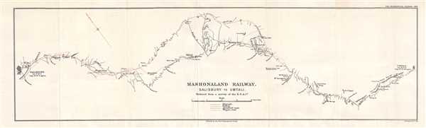
Mashonaland Railway. Salisbury to Umtali.
sold
- Digital Map Information
- Suitable for large format printing
- File Size: 1.89 MB
- File Type: ZIP / TIFF
- ICC color profile embedded
- Delivered instantly via download link
This is a 1900 British South Africa Company map of the railway line between Salisbury (Harare) and Umtali (Mutare) in Rhodesia (Zimbabwe). Printed to accompany a short article in the Geographical Journal published in February 1900, this section ... (more details)
Depicts the Mediterranean islands that were critical to supplying Axis troops in North Africa.
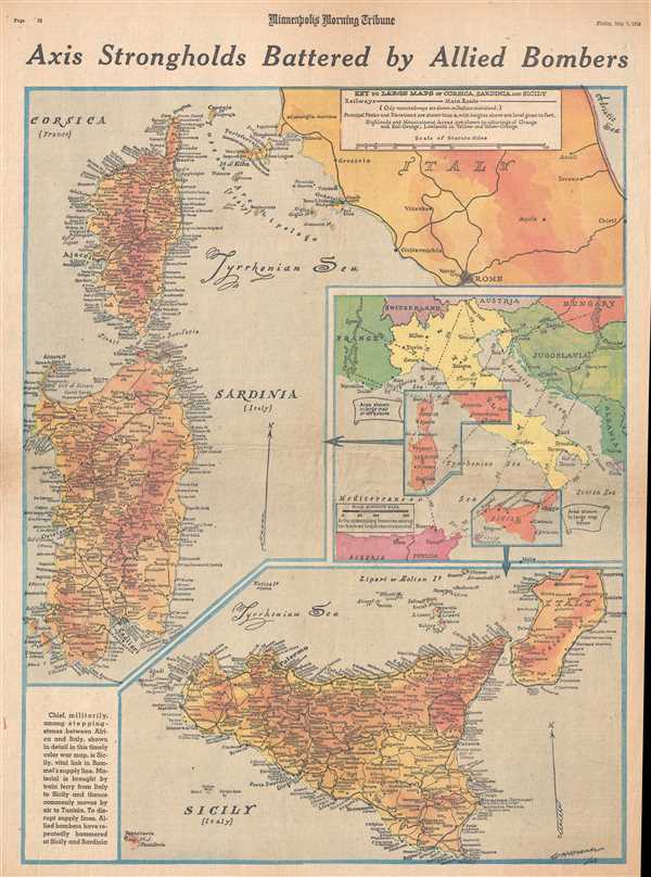
Axis Strongholds Battered by Allied Bombers.
sold
- Digital Map Information
- Suitable for large format printing
- File Size: 11.8 MB
- File Type: ZIP / TIFF
- ICC color profile embedded
- Delivered instantly via download link
This is a Friday, May 7, 1943 William H. Wisner and Minneapolis Morning Tribune map of Italy, Corsica, Sardinia, and Sicily. The map depicts all three islands (Corsica, Sardinia, and Sicily) in full and depicts Italy from the Tyrrhenian Sea to ... (more details)
Russian edition of Tupaia's Chart - a relic of the first Cook Expedition to the South Pacific and an illustration of advanced Polynesian navigation techniques.
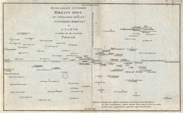
ИЗОБРАЖЕНІЕ ОСТРОВОВЪ ЮЖНАГО МОРЯ ПО ПОКАЗАНИЮ ЖИТЕЛЕЙ ОСТРОВОВЪ ОБЩЕСТВА И O-TAИTИ. / A Chart representing the Isles of the South Sea, according to the notions of the Inhabitants of O'Taheitee and the Neighboring Isles chiefly collected from the accounts of Tupaya.
sold
- Digital Map Information
- Suitable for large format printing
- DPI: 300
- File Size: 3.76 MB
- File Type: ZIP / TIFF
- ICC color profile embedded
- Delivered instantly via download link
A significant discovery of considerable rarity, this is a c. 1777 Russian language version of the Tupaia Chart or map of the Society Islands and Tahiti. The map is based upon the indigenous cartography of Tupaia, a Tahitian navigator who drew ... (more details)
A Portuguese broadside celebrating the Japanese invasion and capture of Singapore.

Singapura em poder dos Japoneses.
sold
- Digital Map Information
- Suitable for large format printing
- File Size: 16.34 MB
- File Type: ZIP / TIFF
- ICC color profile embedded
- Delivered instantly via download link
This is a 1942 Section IV of the German Army High Command's Department of Wehrmacht Propaganda Portuguese language pictorial propaganda broadside created celebrating the Japanese invasion and capture of Singapore. Sixty thousand British troops in Singapore surrendered to the Imperial Japanese Army on February 15, 1942, an event Winston Churchill called 'the worst disaster and largest capitulation in British history'. While the vignettes on the front of the broadside do not appear to support the Axis or the Allies, the text on the verso proves otherwise. The text derides British and American imperialism, particularly with regard to Britain's militarization of Singapore and highlights Singapore's fortress-like qualities. The text at the bottom of the page congratulates Japan and states that the British and the United States will soon be annihilated.
A Description of the Broadside
The broadside features four vignettes illustrating different aspects of the Japanese invasion of Singapore. A brightly colored idyllic view of the city of Singapore is situated on the top left, with a vignette of the Japanese advance toward Singapore along the Malay Peninsula below it on the lower left. This vignette features Japanese soldiers trekking through the jungle behind a tank, while a building burns in the background. On the top right, the Japanese attack on the airport in Singapore is illustrated, complete with depictions of the famed Mitsubishi Zero fighter aircraft and several other Japanese planes, all adorned with the Rising Sun. The fourth vignette in the lower right corner presents Japanese troops marching into Singapore in front of the Victoria Theatre and Concert Hall. A map of the region, situated along the top between the view of the city and the vignette of the Japanese aerial attack on the airport, notes the British and American military bases that had been conquered by the Japanese and also states, that with the fall of Singapore, the line in the Pacific between the United States and India, Africa, and Europe, had been severed.
Portuguese Neutrality during World War II
On September 1, 1939, the day Nazi Germany invaded Poland and officially ignited World War II, Portugal declared that the 600-year-old Anglo-Portuguese Alliance remained intact, but since the British were not seeking Portuguese assistance, Portugal would remain neutral in the war. In an aide-mémoire issued on September 5, 1939, the British Government confirmed its understanding of Portugal's statement and supported its neutrality. Even so, Portugal played a critical role in the war, particularly with regard to the refugee crisis suffered by so many during the war, and in saving Europe's Jewish population. Several Portuguese ambassadors and consuls general were responsible for handing out visas to refugees and Europe's Jewish community. The Portuguese Ambassador in Budapest, Carlos Sampaio Garrido, helped an estimated 1,000 Hungarian Jews in 1944 and the Portuguese consul general in Bordeaux helped an undetermined number of refugees by issuing them visas. Around 2,500 refugees were evacuated from Gibraltar in July 1940 ahead of the expected German attack and were welcomed by Portuguese Madeira. (more details)
A Description of the Broadside
The broadside features four vignettes illustrating different aspects of the Japanese invasion of Singapore. A brightly colored idyllic view of the city of Singapore is situated on the top left, with a vignette of the Japanese advance toward Singapore along the Malay Peninsula below it on the lower left. This vignette features Japanese soldiers trekking through the jungle behind a tank, while a building burns in the background. On the top right, the Japanese attack on the airport in Singapore is illustrated, complete with depictions of the famed Mitsubishi Zero fighter aircraft and several other Japanese planes, all adorned with the Rising Sun. The fourth vignette in the lower right corner presents Japanese troops marching into Singapore in front of the Victoria Theatre and Concert Hall. A map of the region, situated along the top between the view of the city and the vignette of the Japanese aerial attack on the airport, notes the British and American military bases that had been conquered by the Japanese and also states, that with the fall of Singapore, the line in the Pacific between the United States and India, Africa, and Europe, had been severed.
Portuguese Neutrality during World War II
On September 1, 1939, the day Nazi Germany invaded Poland and officially ignited World War II, Portugal declared that the 600-year-old Anglo-Portuguese Alliance remained intact, but since the British were not seeking Portuguese assistance, Portugal would remain neutral in the war. In an aide-mémoire issued on September 5, 1939, the British Government confirmed its understanding of Portugal's statement and supported its neutrality. Even so, Portugal played a critical role in the war, particularly with regard to the refugee crisis suffered by so many during the war, and in saving Europe's Jewish population. Several Portuguese ambassadors and consuls general were responsible for handing out visas to refugees and Europe's Jewish community. The Portuguese Ambassador in Budapest, Carlos Sampaio Garrido, helped an estimated 1,000 Hungarian Jews in 1944 and the Portuguese consul general in Bordeaux helped an undetermined number of refugees by issuing them visas. Around 2,500 refugees were evacuated from Gibraltar in July 1940 ahead of the expected German attack and were welcomed by Portuguese Madeira. (more details)
Rare separate Issue map of America with ghosted Pacific Northwest illustrating cartographic ambiguity.
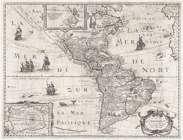
Carte de L'Amerique Corrigee et augmentee dessus toutes les autres cy devant faictes.
sold
- Digital Map Information
- Suitable for large format printing
- DPI: 300
- File Size: 11.77 MB
- File Type: ZIP / TIFF
- ICC color profile embedded
- Delivered instantly via download link
This is a rare and significant separately issued 1640 map of America by Petrus Bertius. The map covers all of North and South America, as well as Central America, the West Indies, and the surrounding areas, including adjacent parts of Spain, ... (more details)
Printed a week after the Japanese invasion of Luzon.
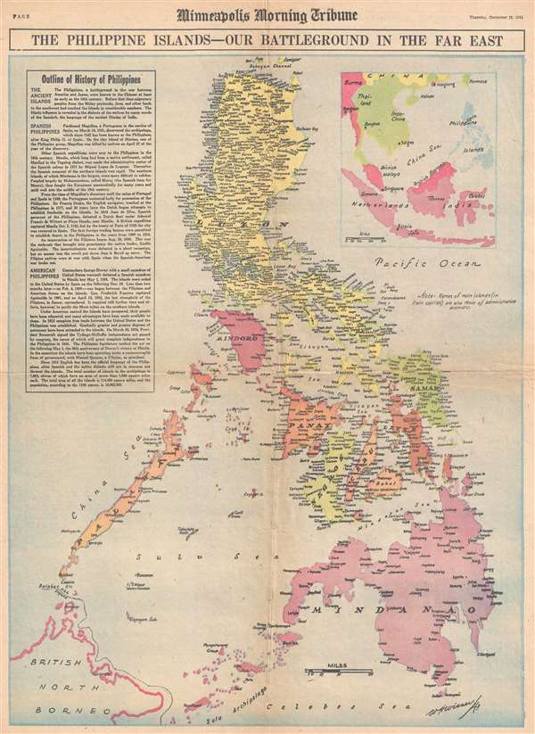
The Philippine Islands - Our Battleground in the Far East.
sold
- Digital Map Information
- Suitable for large format printing
- File Size: 10.18 MB
- File Type: ZIP / TIFF
- ICC color profile embedded
- Delivered instantly via download link
This is a Thursday, December 18, 1941, W. H. Wisner and Minneapolis Morning Tribune map of the Philippines. Printed eight days after the first Japanese landing on Luzon, this map depicts the Philippine Archipelago from Babuyan Channel to the ... (more details)
Published a week after American forces landed on Leyte and returned to the Philippines.
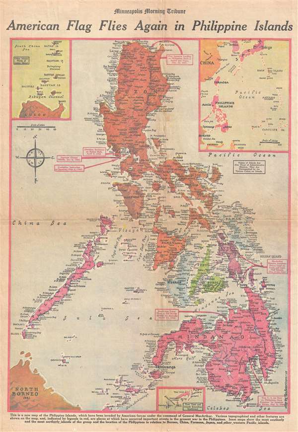
American Flag Flies Again in Philippine Islands.
sold
- Digital Map Information
- Suitable for large format printing
- File Size: 11.51 MB
- File Type: ZIP / TIFF
- ICC color profile embedded
- Delivered instantly via download link
This is a Friday, October 27, 1944 Van Swearingen and Minneapolis Morning Tribune map of the Philippines a week after the American landings on Leyte. The map depicts the region from Luzon to Mindanao and Borneo and from Palawan and the China ... (more details)
The summer supply route between the United States and Russia through the Arctic Circle.
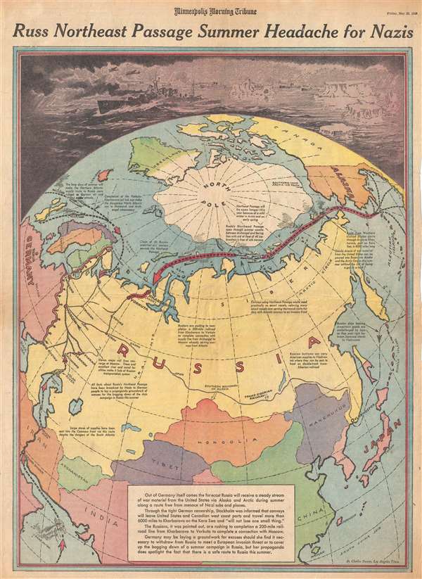
Russ Northeast Passage Summer Headache for Nazis.
sold
- Digital Map Information
- Suitable for large format printing
- File Size: 11.35 MB
- File Type: ZIP / TIFF
- ICC color profile embedded
- Delivered instantly via download link
This is a Friday, May 28, 1943 Charles Hamilton Owens and Minneapolis Morning Tribune pictorial map of Asia illustrating the Northeast Passage. The map depicts the Earth from a polar perspective, with the North Pole at the center, Europe and ... (more details)
Five presumed options for the Allied invasion of continental Europe - where would they decide to land troops?
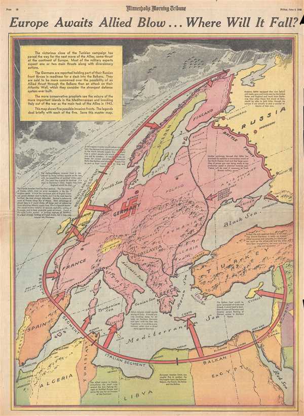
Europe Awaits Allied Blow…Where Will It Fall?
sold
- Digital Map Information
- Suitable for large format printing
- File Size: 11.66 MB
- File Type: ZIP / TIFF
- ICC color profile embedded
- Delivered instantly via download link
This is a Friday, June 4, 1943 Minneapolis Morning Tribune map of Europe preparing for the presumed upcoming Allied invasion. The map depicts the continent from the Atlantic Ocean to the Eastern Front between the Russians and the Germans ... (more details)
Illustrates the final stages of Allied victory in North Africa against Erwin Rommel and the Afrika Korps.
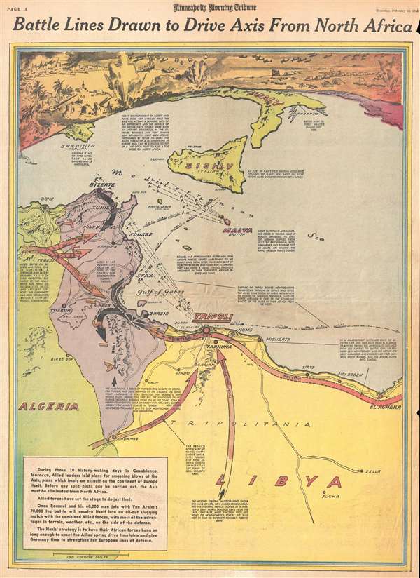
Battle Lines Drawn to Drive Axis From North Africa.
sold
- Digital Map Information
- Suitable for large format printing
- File Size: 10.36 MB
- File Type: ZIP / TIFF
- ICC color profile embedded
- Delivered instantly via download link
This is a February 18, 1943 Minneapolis Morning Tribune pictorial map of the final stages of the Allied campaign against Nazi Field Marshal Erwin Rommel and the Afrika Korps in North Africa. The map depicts the region from Algeria to ... (more details)
Labels all of the military installations in the continental United States from coast to coast.
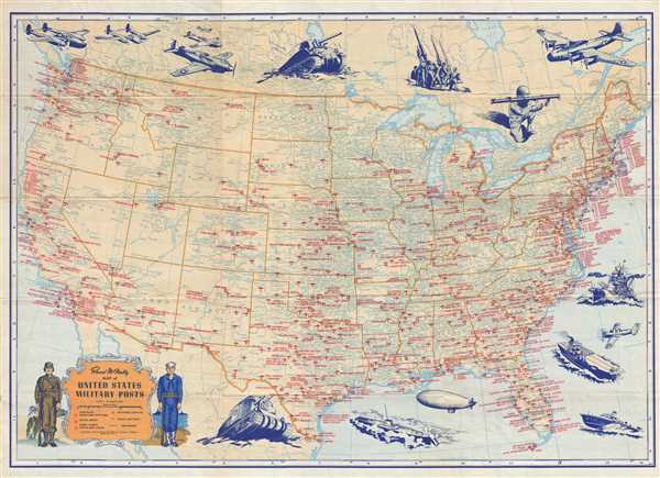
Rand McNally Map of United States Military Posts.
sold
- Digital Map Information
- Suitable for large format printing
- File Size: 15.99 MB
- File Type: ZIP / TIFF
- ICC color profile embedded
- Delivered instantly via download link
This is a 1944 Rand McNally map of the United States which labels all the military installations from California to New York. The map depicts the United States from the Pacific Ocean to the Atlantic Ocean and from Canada to Mexico. ... (more details)
One of the most graphically striking maps of the San Francisco Bay area.
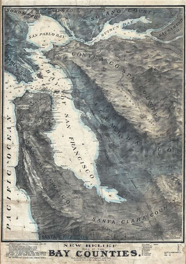
New Relief Map of the Bay Counties.
sold
- Digital Map Information
- Suitable for large format printing
- File Size: 63.9 MB
- File Type: ZIP / TIFF
- ICC color profile embedded
- Delivered instantly via download link
One of the more graphically striking maps of the San Francisco Bay Area to appear in the early 20th century This is a scarce 1905 Whitaker and Ray wall map of the San Francisco Bay Area. The map covers the entire Bay Area, from ... (more details)
Rare Spanish nautical chart of the Balearic Islands.
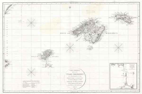
Carta Esferica de las Islas Baleares y Pithyusas, arreglada a la que se construyo en 1807 en la Dirección Hidrografica de Madrid.
sold
- Digital Map Information
- Suitable for large format printing
- DPI: 300
- File Size: 10.36 MB
- File Type: ZIP / TIFF
- ICC color profile embedded
- Delivered instantly via download link
A rare 1812 Dirección de Hidrografía nautical chart or maritime map of the Balearic Islands: Mallorca, Menorca, Ibiza and Formentera. The chart offers extraordinarily detail throughout with topography, town names rivers, ... (more details)
Historically significant exploration map of the American West including John Jacob Astor's Astoria trading post.

Sketch of the Routes of Hunt and Stuart.
sold
- Digital Map Information
- Suitable for large format printing
- DPI: 300
- File Size: 3.72 MB
- File Type: ZIP / TIFF
- ICC color profile embedded
- Delivered instantly via download link
A map of great historical importance, this is Washington Irving's scarce 1836 map detailing Wilson P. Hunt's 1810 westward trip from St. Louis, Missouri, to Astor's newly founded trading post Astoria at the mouth of the ... (more details)
Extremely rare large nuatical chart of Scottish waters by David Steel!
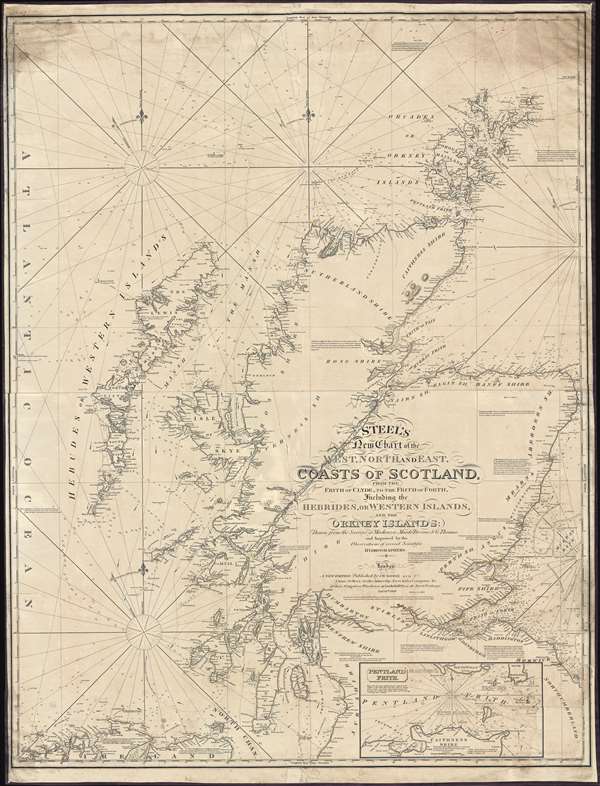
Steel's New Chart of the West, North, and East Coasts of Scotland from the Frith of Clyde to the Frith of Forth, Including the Hebrides, or Western Islands, and the Orkney Islands.
sold
- Digital Map Information
- Suitable for large format printing
- DPI: 300
- File Size: 50.25 MB
- File Type: ZIP / TIFF
- ICC color profile embedded
- Delivered instantly via download link
This is an 1844 David Steel and John William Norie nautical chart or maritime map of the coasts of Scotland. The chart depicts the region from the Atlantic Ocean to Fair Island, Aberdeenshire, and the Murray Bank and from the Orkney Island to Northumberland, Ayreshire, and Ireland. Highly detailed, myriad depth soundings are indicated throughout. Counties within Scotland are labeled, along with several Lochs (including Loch Ness). Numerous firths along the Scottish coast are also illustrated in detail. Cities, towns, villages, and other locations are labeled all along the coast, including Aberdeen, Montrose, Dundee, Perth, Stirling, and Glasgow. Castle Urquhart is also labeled along the coast of Loch Ness. An inset map of Pentland Firth is situated along the bottom border. Lighthouses are labeled throughout the map and indicated by red and yellow manuscript notations. Information concerning each of these lighthouses is present as well, providing details about each lighthouse's functionality. (more details)