
Engrossing pictorial map of Lake Champlain, New York on the model of Josephine Wickser.

A Romance Map of the Northern Gateway.
sold
- Digital Map Information
- Suitable for large format printing
- File Size: 13.94 MB
- File Type: ZIP / TIFF
- ICC color profile embedded
- Delivered instantly via download link
This is a 1934 C. Eleanor Hall pictorial map of Lake Champlain. The map depicts Lake Champlain and the surrounding region in New York and Vermont. This map is highly detailed and provides the viewer with ample information about the colonial and early history of the ... (more details)
Beautiful old color Vaugondy map of Belgium, the Netherlands, and France.
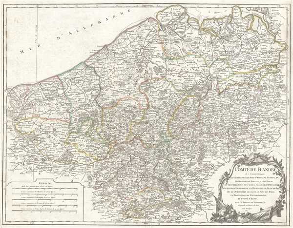
Comté de Flandre où se trouve distingués les bailliages de Berg St. Winox, de Gurnes, de Bourbourg, de Bailleul, et de Douay, les Chatellenies de Cassel, de Lille, d'Ypres, de Courtray, d'Oudenarde, le Tournesis, le Franc-de-Bruges, le Burgraviat de Gand, le Pays de Waes, le Seigneurie de Dendermonde, le Comté d'Alost. Par le Sr. Robert de Vaugondy, fils, Géographe ordinaire du Roi.
sold
- Digital Map Information
- Suitable for large format printing
- Full resolution TIFF file
- ICC color profile embedded
- Delivered instantly via download link
This is a 1752 Didier Robert de Vaugondy map of Flanders. The map depicts the northern half of Belgium, the extreme southern portion of the Netherlands, and extreme northeastern France, from the English Channel ( Mer d'Allemagne ) on the left to the Duché de ... (more details)
The earliest chart to depict the heights of mountains and the lengths of rivers together in one illustration' - Rumsey

New and Improved View of the Comparative Heights, of the Principal Mountains and Lengths of the Principal Rivers in the World.
sold
- Digital Map Information
- Suitable for large format printing
- DPI: 300
- File Size: 5.78 MB
- File Type: ZIP / TIFF
- ICC color profile embedded
- Delivered instantly via download link
A groundbreaking convention establishing map of extreme scarcity, this is William Darton and W. R. Gardner's 1823 comparative mountains and rivers of the world chart. According to Rumsey this is the first known example of a comparative chart to depict both ... (more details)
The finest 19th century Comparative Mountains and Rivers Chart.
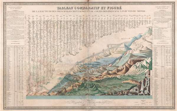
Tableau Comparatif et Figure de La Hauteur des Principales Montagnes et du Cours des Principaux Fleuves due Monde.
sold
- Digital Map Information
- Suitable for large format printing
- DPI: 300
- File Size: 25.84 MB
- File Type: ZIP / TIFF
- ICC color profile embedded
- Delivered instantly via download link
This is Andriveau and Goujon's 1838 comparative mountains and rivers chart. This extraordinary chart is considered the highest expression of the mountains and rivers convention as developed in the 19th century. No mountains and rivers chart before or ... (more details)
Exceptional signed Richard Rummel view of Harvard University from above Harvard Square.

[Harvard University]
sold
- Digital Map Information
- Suitable for large format printing
- File Size: 12.48 MB
- File Type: ZIP / TIFF
- ICC color profile embedded
- Delivered instantly via download link
A scarce SIGNED 1906 Richard Rummell photogravure bird's-eye view of Harvard University in Cambridge, Massachusetts. The view embraces the entire campus as seen looking northeast from a point some 300 feet above the southwest corner of the campus. ... (more details)
Attractive hand colored map of the Great Lakes and the American colonies issued just prior to the French and Indian War.
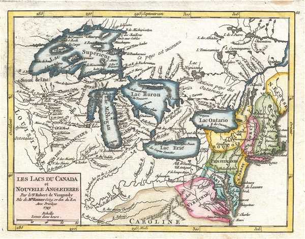
Les Lacs du Canada et Nouvelle Angleterre. Par le Sr. Robert de Vaugondy, fils de Mr. Robert Géog. ordin du Roi
sold
- Digital Map Information
- Suitable for large format printing
- DPI: 300
- File Size: 1.93 MB
- File Type: ZIP / TIFF
- ICC color profile embedded
- Delivered instantly via download link
This is a hand colored 1749 Didier Robert de Vaugondy map of the Great Lakes on the cusp of the French and Indian War (1754 – 1763). The organization of the map is significant, with the French controlled Great Lakes dominating the map. The ... (more details)
Uncommon map of the Mississippi River and Louisiana issued a few years before the French and Indian War.
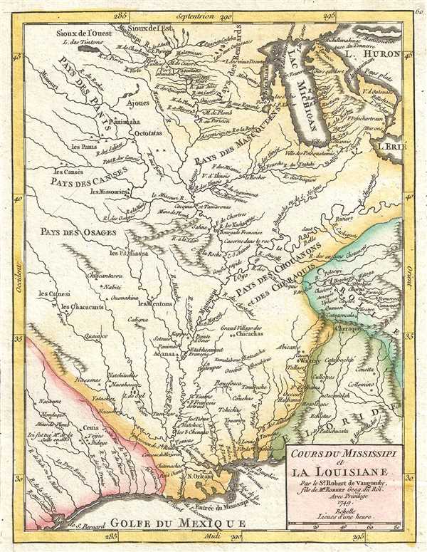
Cours du Mississipi et la Louisiane. Par le Sr. Robert de Vaugondy, fils de Mr. Robert Géog. Du Roi.
sold
- Digital Map Information
- Suitable for large format printing
- DPI: 300
- File Size: 1.53 MB
- File Type: ZIP / TIFF
- ICC color profile embedded
- Delivered instantly via download link
This is a hand colored 1749 Didier Robert de Vaugondy map of the Mississippi River and Louisiana. Issued just before the French and Indian War (1754 – 1763), this map focuses on the Mississippi River, depicting from north of Lake Michigan at ... (more details)
Bellin's illustration of 18th century French claims to the American Southeast.
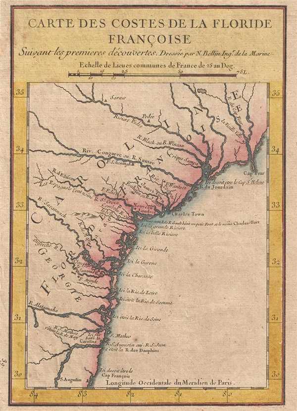
Carte des Costes de la Floride Francoise Suivant les premieres decouvertes.
sold
- Digital Map Information
- Suitable for large format printing
- DPI: 300
- File Size: 1.31 MB
- File Type: ZIP / TIFF
- ICC color profile embedded
- Delivered instantly via download link
A beautiful hand colored example of Jaques Nicholas Bellin's unusual and interesting 1744 map of the American Southeast. The map depicts the southeastern coast of the modern day United States roughly from St. Augustine, Florida to Cape Fear, ... (more details)
Uncommon map of Florida and Carolina on the cusp of the French and Indian War.

La Floride divisee en Floride et Caroline. Par le Sr. Robert de Vaugondy, Fils de Mr. Robert Geogr. ordin. du Roi.
sold
- Digital Map Information
- Suitable for large format printing
- DPI: 300
- File Size: 1.34 MB
- File Type: ZIP / TIFF
- ICC color profile embedded
- Delivered instantly via download link
This is a hand colored 1749 Didier Robert de Vaugondy map of Florida, Georgia, and Carolina published just a few years prior to the French and Indian War (1754 – 1763). The map depicts from French Louisiana on the left to the Atlantic ... (more details)
Gorgeous hand colored map of the West Indies.

Les Isles Antilles. Par le Sr. Robert de Vaugondy, fils de Mr. Robert Géogr. ord du Roi.
sold
- Digital Map Information
- Suitable for large format printing
- DPI: 300
- File Size: 1.49 MB
- File Type: ZIP / TIFF
- ICC color profile embedded
- Delivered instantly via download link
This is a hand colored 1749 Didier Robert de Vaugondy map of the West Indies. The map depicts from Cuba on the left to Trinidad and Barbados on the right and from Florida at the top to the northern coast of South America at the bottom ... (more details)
Uncommon map of the English Colonies in North America on the cusp of the French and Indian War.
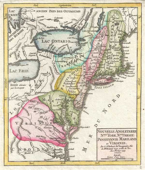
Nouvelle Angleterre, Nouvelle York, Nouvelle Jersey. Pensilvanie Mariland et Virginie. Par le Sr. Robert de Vaugondy Fils de Mr. Robert Geog. ordin. du Roi
sold
- Digital Map Information
- Suitable for large format printing
- DPI: 300
- File Size: 1.35 MB
- File Type: ZIP / TIFF
- ICC color profile embedded
- Delivered instantly via download link
This is a hand colored 1749 Didier Robert de Vaugondy map of the English Colonies in North America, including New England and the Mid-Atlantic colonies, on the cusp of the French and Indian War (1754 – 1763). The organization of the ... (more details)
Uncommon map of New Mexico and Texas illustrating Peñalosa's city of gold, Teguayo, and French claims in Texas.
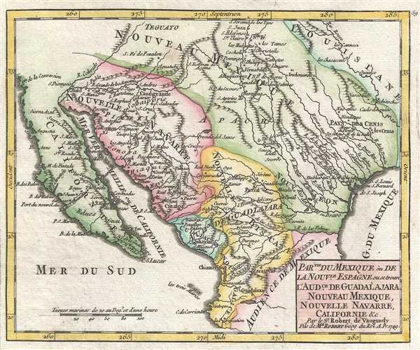
Partie du Mexique ou de la Nouvelle Espagne ou se trouve l'Audience de Guadalajara, Nouveau Mexique, Nouvelle Navarre, Californie, etc. Par le Sr. Robert de Vaugondy, Fils de Mr. Robert Géog du Roi.
sold
- Digital Map Information
- Suitable for large format printing
- DPI: 300
- File Size: 1.46 MB
- File Type: ZIP / TIFF
- ICC color profile embedded
- Delivered instantly via download link
This is a hand colored 1749 Didier Robert de Vaugondy map of Mexico and Texas. Issued on the cusp of the French and Indian War, this map depicts the southwestern United States from Santa Fe south to central Mexico and from California ... (more details)
Beautiful hand colored map of Malta and Gozo.
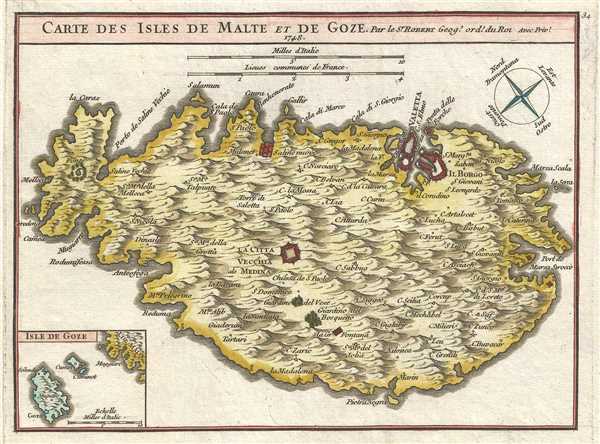
Carte des Isles de Malte et de Goze. Par le Sr. Robert Geog. Ord. du Roi.
sold
- Digital Map Information
- Suitable for large format printing
- DPI: 300
- File Size: 1.54 MB
- File Type: ZIP / TIFF
- ICC color profile embedded
- Delivered instantly via download link
This is a hand colored 1748 Gilles Robert de Vaugondy map of Malta and adjacent Gozo. Oriented to the Northeast, this map depicts the island of Malta from Melecca on the left to the Port de Marza Strocco on the right and from Valetta ... (more details)
Uncommon map of the Philippines.
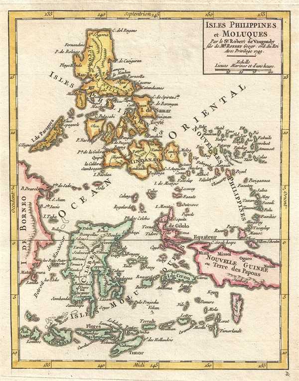
Isles Philippines et Moluques Par le Sr. Robert de Vaugondy fils de Mr. Robert Geogr. ord. du Roi.
sold
- Digital Map Information
- Suitable for large format printing
- DPI: 300
- File Size: 1.46 MB
- File Type: ZIP / TIFF
- ICC color profile embedded
- Delivered instantly via download link
This is a hand colored 1749 Didier Robert de Vaugondy map of the Philippines and Indonesia. The map depicts the Philippine Islands at the top to the island of Timor at the bottom and from Borneo on the left to New Guinea on the ... (more details)
Attractive hand colored map of Indonesia and Malaysia, including the island of Singapore.

Les Isles de la Sonde. Par le Sr. Robert de Vaugondy, Fils e Mr. Robert Geogr. du Roi.
sold
- Digital Map Information
- Suitable for large format printing
- DPI: 300
- File Size: 1.35 MB
- File Type: ZIP / TIFF
- ICC color profile embedded
- Delivered instantly via download link
This is a hand colored 1749 Didier Robert de Vaugondy map of Indonesia and Malaysia, including Singapore (included by not labeled). The map depicts the extreme southern portion of the Malay peninsula, Singapore, Sumatra, Java, ... (more details)
Intriguing 17th century royal boat procession in Thailand (Siam).

Balons Siamois.
sold
- Digital Map Information
- Suitable for large format printing
- DPI: 300
- File Size: 0.74 MB
- File Type: ZIP / TIFF
- ICC color profile embedded
- Delivered instantly via download link
This is a 1686 Pierre Paul Sevin and Cornelius Vermeulen vignette map of the boats of the King of Siam (Thailand). The vignette depicts the procession of royal boats on the Chao Phraya River taking the French ambassador and ... (more details)
Map of the Red River (Sông Hồng), Vietnam, including the capital city of Hanoi, then called Cacho.

Carte du Cours de la Riviere de Tunquin depuis Cacho jusqu'a la Mer. Levée par un Navigateur Anglois.
sold
- Digital Map Information
- Suitable for large format printing
- Full resolution TIFF file
- ICC color profile embedded
- Delivered instantly via download link
This is a hand colored 1750 Jacques Nicholas Bellin map of the Tonkin (Tunquin) River, Vietnam. The map depicts the river's course from Cacho (modern Hanoi) to the Bay of Tonkin. The map is oriented slightly to the ... (more details)
Beautiful hand colored map of China inluding Korea and Taiwan (Formosa).

Empire de la Chine Par le Sr. Robert de Vaugondy fils de Mr. Robert Geogr. ord du Roi.
sold
- Digital Map Information
- Suitable for large format printing
- DPI: 300
- File Size: 1.46 MB
- File Type: ZIP / TIFF
- ICC color profile embedded
- Delivered instantly via download link
This is a hand colored 1749 Didier Robert de Vaugondy map of China and Korea. The map depicts from Tibet on the left eastward to the Chinese coast and Taiwan/Formosa on the right and from 'Chinese Tartary' and the ... (more details)
Rare map of Japan and Korea ientifying the Sea of Korea.
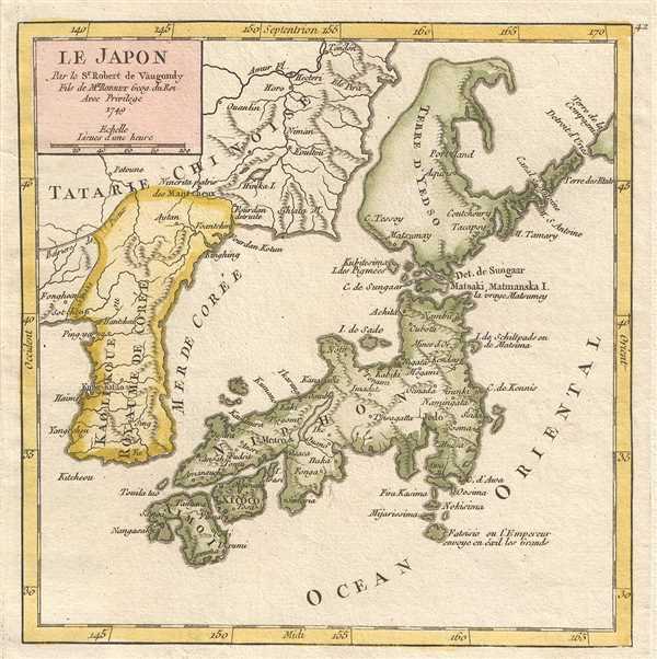
Le Japon Par le Sr. Robert de Vaugondy Fils de Mr. Robert Geog. du Roi.
sold
- Digital Map Information
- Suitable for large format printing
- DPI: 300
- File Size: 1.13 MB
- File Type: ZIP / TIFF
- ICC color profile embedded
- Delivered instantly via download link
This is a hand colored 1749 Didier Robert de Vaugondy map of Japan and Korea, with Sea of Korea identified. The map centers on the home islands of Japan and depicts from Korea and China to the Pacific Ocean (Ocean ... (more details)
Very rare map of Cape Breton Island, Canada.
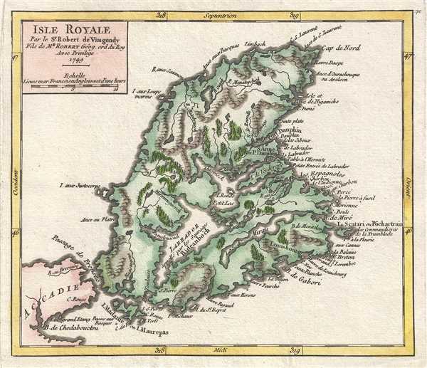
Isle Royale. Par le Sr. Robert de Vaugondy, Fils de Mr. Robert Géog. ord du Roi
sold
- Digital Map Information
- Suitable for large format printing
- DPI: 300
- File Size: 1.35 MB
- File Type: ZIP / TIFF
- ICC color profile embedded
- Delivered instantly via download link
This is a hand colored 1749 Didier Robert de Vaugondy map of Cape Breton Island. Specific maps of Cape Breton Island are extremely rare. The map depicts the whole of Cape Breton Island from Port Hawkesbury to Bay ... (more details)