
1763 Gazzettiere Americano Map of the British Colonies: New York, Pennsylvania, New Jersey, Masssach
Scarce French and Indian War Era Map showing French settlements in Pennsylvania.

Carta Della Nuova Inghilterra Nuova Iork, e Pennsilvania.
sold
- Digital Map Information
- Suitable for large format printing
- DPI: 300
- File Size: 3.56 MB
- File Type: ZIP / TIFF
- ICC color profile embedded
- Delivered instantly via download link
An uncommon 1763 Italian edition of Jacques Nicholas Bellin's 1763 map of the English Colonies from Pennsylvania to Maine. The map covers from Lake Erie and Lake Ontario south to the Potomac River and eastward to the Atlantic seaboard. The coastline is ... (more details)
Scarce French and Indian War Era Map showing Fort Dequesne.
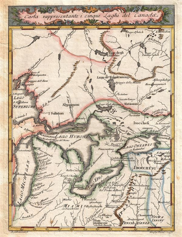
Carta Rappresentante i Cinque Laghi del Canada.
sold
- Digital Map Information
- Suitable for large format printing
- DPI: 300
- File Size: 2.66 MB
- File Type: ZIP / TIFF
- ICC color profile embedded
- Delivered instantly via download link
This is an uncommon and detailed 1763 Italian issue map of the Great Lakes and adjacent territories. The map covers all five of the Great Lakes although Lake Superior is only partially represented. It extends northwards well beyond Lake Superior, ... (more details)
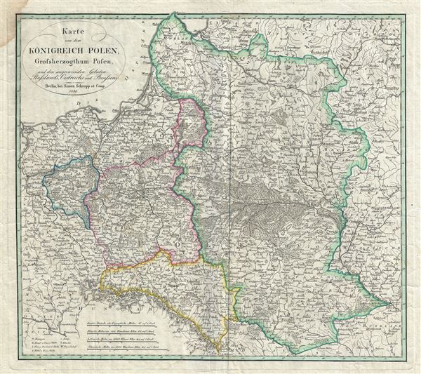
Karte von dem Konigreich Polen, Grossherzogthum Posen, und den angrenzenden Gebieten Russlands, Oestreichs, und Preussens.
sold
- Digital Map Information
- Suitable for large format printing
- DPI: 300
- File Size: 14.34 MB
- File Type: ZIP / TIFF
- ICC color profile embedded
- Delivered instantly via download link
This is a beautiful example of Simon Schropp's 1831 map of Poland and Lithuania. The map depicts the Kingdom of Poland (Congress Poland), the Grand Duchy of Posen and neighboring territories of Austria, Russia and Prussia. It covers the modern ... (more details)
An iconic map of Shanghai, China, featuring a dramatic panoramic photograph of the Bund.
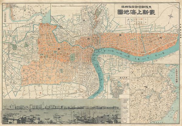
Saishin Shanhai chizu. Ōsaka Asahi Shinbunsha tokusen. / 大阪朝日新聞社特撰 . 最新上海地圖. / Osaka Asahi Shimbun Special Selection. Newest Map of Shanghai.
sold
- Digital Map Information
- Suitable for large format printing
- File Size: 22.46 MB
- File Type: ZIP / TIFF
- ICC color profile embedded
- Delivered instantly via download link
This is a rare and beautiful Showa 7 or 1932 map of Shanghai, China. This map was issued by the Japanese daily, Osaka Asahi Shimbun , to illustrate events associated with the 'January 28 Incident' or 'Shanghai Incident' (January 28 – March 3, ... (more details)
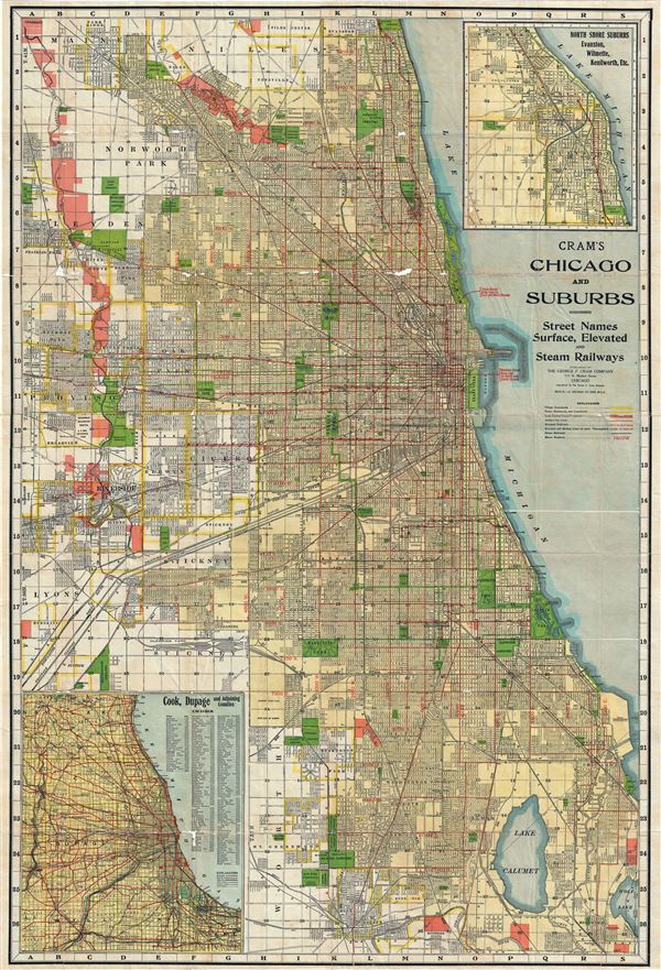
Cram's Chicago and Suburbs.
sold
- Digital Map Information
- Suitable for large format printing
- File Size: 61.68 MB
- File Type: ZIP / TIFF
- ICC color profile embedded
- Delivered instantly via download link
This is a large 1920 map or city plan of Chicago, Illinois by G. F. Cram. This enormous pocket map was issued as a tourist guide and depicts the city of Chicago and its suburbs in great detail. It covers from Park Ridge south as far as Lake ... (more details)
A tribute to the Pacific Railroad and the conquest of the American West.
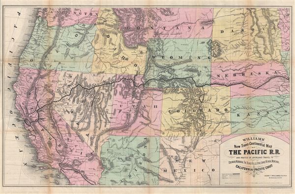
Williams' New Trans-Continental Map of The Pacific R.R. and Routes of Overland Travel to Colorado, Nebraska, The Black Hills, Utah, Idaho, Nevada, Montana, California and the Pacific Coast.
sold
- Digital Map Information
- Suitable for large format printing
- File Size: 30.27 MB
- File Type: ZIP / TIFF
- ICC color profile embedded
- Delivered instantly via download link
A scarce and exceptionally attractive first edition example of Henry Williams' 1876 map of the Pacific Railroad. Centered on the line of the Pacific Railroad as it travels westward across the continent to California, this map covers from ... (more details)

Colton's West Indies.
sold
- Digital Map Information
- Suitable for large format printing
- File Size: 9.26 MB
- File Type: ZIP / TIFF
- ICC color profile embedded
- Delivered instantly via download link
An excellent 1884 example of Colton's map of the West Indies. Like most of Colton's North America maps, this map was derived from an earlier wall map of North America produced by Colton and D. Griffing Johnson. Centered on Santo Domingo ... (more details)
A scarce and influential map illustrating the political situation around the Great Lakes and in Canada early in the American Revolutionary War.
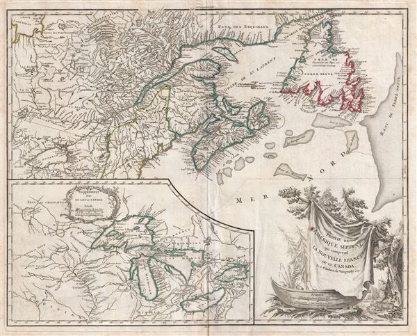
Partie De L'Amerique Septent. Qui Comprend La Nouvelle France ou Le Canada.
sold
- Digital Map Information
- Suitable for large format printing
- DPI: 300
- File Size: 17.01 MB
- File Type: ZIP / TIFF
- ICC color profile embedded
- Delivered instantly via download link
A fine example of Robert de Vaugondy's 1778 map of former French dominions in Canada and in the vicinity of the Great Lakes at the outset of the American Revolutionary War. Essentially two maps on a single sheet. The primary map ... (more details)
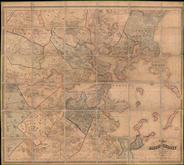
Map of Boston and its vicinity, from Actual Surveys
sold
- Digital Map Information
- Suitable for large format printing
- File Size: 29.7 MB
- File Type: ZIP / TIFF
- ICC color profile embedded
- Delivered instantly via download link
An expansive 1859 dissected case map of Boston, Massachusetts and its immediate vicinity compiled by Henry F. Walling. This enormous production is one of the large and most detailed maps of Boston to appear in the 19th century. ... (more details)
The largest original map of Victorian London obtainable.
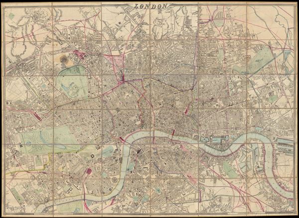
London.
sold
- Digital Map Information
- Suitable for large format printing
- File Size: 25.36 MB
- File Type: ZIP / TIFF
- ICC color profile embedded
- Delivered instantly via download link
A remarkable and monumental map of London, this is Weller and Cassell's 1866 wall map of London. When it was first issued in 1861 this was the largest scale map of London yet produced. Cassell was justly proud of his map ... (more details)

Bird's-Eye View of the Battle of Tel-El-Kebir.
sold
- Digital Map Information
- Suitable for large format printing
- File Size: 25.39 MB
- File Type: ZIP / TIFF
- ICC color profile embedded
- Delivered instantly via download link
This is a stunning c. 1890 birds-eye view of the Battle of Tel-El-Kebir, drawn by G. W. Bacon. The view beautifully depicts the battle fought between British military and the Egyptian army under Ahmed Arabi during the ... (more details)

The Bombardment of Alexandria.
sold
- Digital Map Information
- Suitable for large format printing
- File Size: 24.03 MB
- File Type: ZIP / TIFF
- ICC color profile embedded
- Delivered instantly via download link
This is an uncommon c. 1890 birds-eye view of the bombardment of Alexandria, drawn by G. W. Bacon. The view beautifully depicts the bombardment of the city of Alexandria, Egypt by the British Mediterranean Fleet ... (more details)
Possibly the most beautiful map and view of Central Park ever published.

Central Park, New York, A picturesque Guide through the whole Park showing all the improvements up to June 1865.
sold
- Digital Map Information
- Suitable for large format printing
- File Size: 14.56 MB
- File Type: ZIP / TIFF
- ICC color profile embedded
- Delivered instantly via download link
An altogether extraordinary hand colored birds-eye view map of New York City's Central Park prepared and printed in 1865 by the famous Boston lithographer Louis Prang. Graced with Prang's extraordinary engraving ... (more details)

Untitled.
sold
- Digital Map Information
- Suitable for large format printing
- DPI: 300
- File Size: 4.05 MB
- File Type: ZIP / TIFF
- ICC color profile embedded
- Delivered instantly via download link
This is a beautiful example of Joannes van Keulen's 1728 nautical chart or maritime map of the northern coast of Sumatra, Indonesia. Oriented to the west, the map covers the northern part of modern day Aceh, ... (more details)
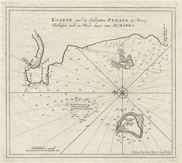
Kaarte van de Eylanden Pysang by Padang Geleegen aan de West kust van Sumatra.
sold
- Digital Map Information
- Suitable for large format printing
- DPI: 300
- File Size: 3.89 MB
- File Type: ZIP / TIFF
- ICC color profile embedded
- Delivered instantly via download link
This is a beautiful example of Joannes van Keulen's 1728 nautical chart or maritime map of Pisang Island, a small island near Padang, on the west coast of Sumatra, Indonesia. Oriented to the west, this map ... (more details)
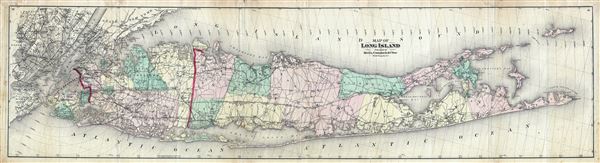
Map of Long Island.
sold
- Digital Map Information
- Suitable for large format printing
- File Size: 34.59 MB
- File Type: ZIP / TIFF
- ICC color profile embedded
- Delivered instantly via download link
A first edition, first issue, of one of the largest and most impressive maps of Long Island, New York to appear in the 19th century. Published in 1873, this magnificent map covers the whole of Long Island ... (more details)

India.
sold
- Digital Map Information
- Suitable for large format printing
- File Size: 9.31 MB
- File Type: ZIP / TIFF
- ICC color profile embedded
- Delivered instantly via download link
This is a beautiful 1943 or Showa 18 large format map of India, issued by the Japanese during World War II. It covers all of India and Pakistan in great detail, and includes Sri Lanka. The map offers ... (more details)

The Western Hemisphere.
sold
- Digital Map Information
- Suitable for large format printing
- DPI: 300
- File Size: 19.22 MB
- File Type: ZIP / TIFF
- ICC color profile embedded
- Delivered instantly via download link
This is a delightfully whimsical school boy manuscript map of the Western Hemisphere by Henry Whitney. It depicts North America, Central America and South America on a hemispherical projection. ... (more details)

The United States Game.
sold
This is an unusual and attractive 1901 game board of the United States Game, by the Parker Brothers. Considered one of the best of the Parker Games, it consists of a game board featuring the map ... (more details)
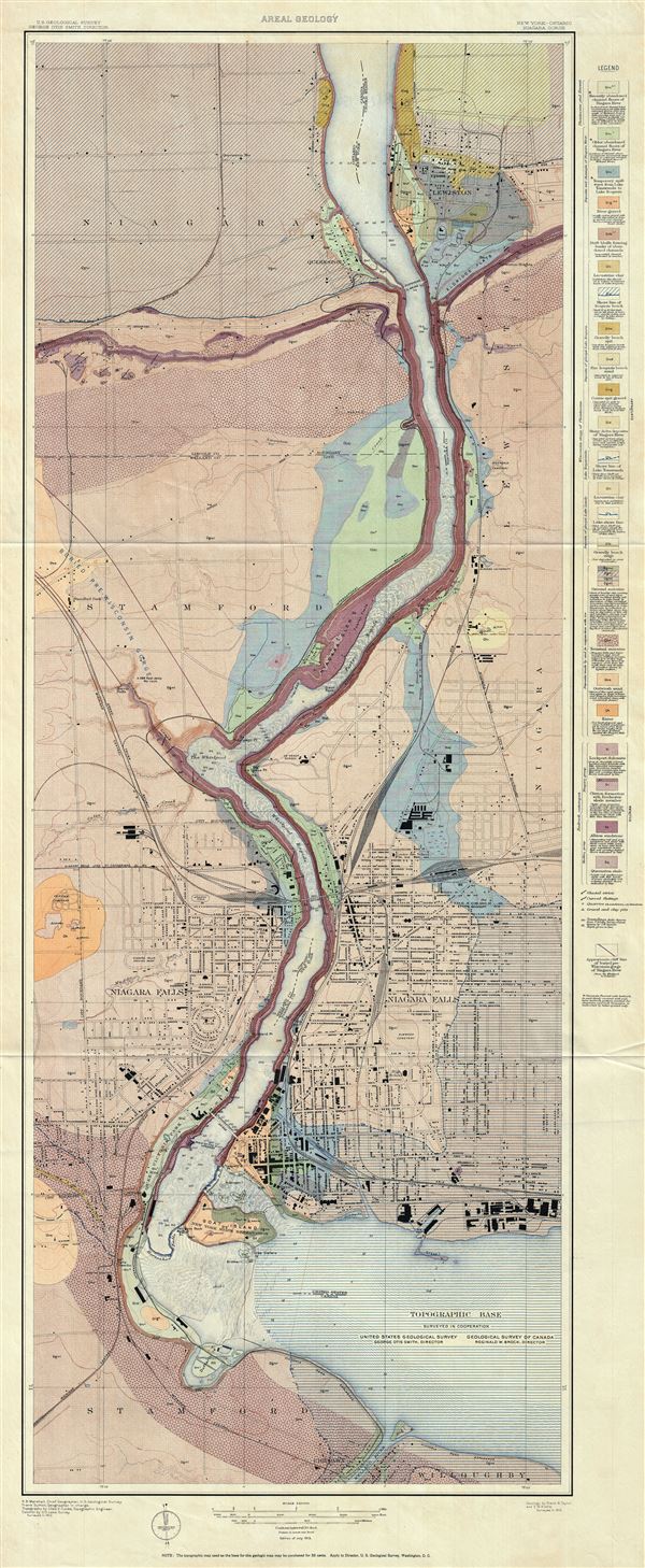
New York - Ontario. Niagara Gorge. Areal Geology.
sold
- Digital Map Information
- Suitable for large format printing
- File Size: 49.23 MB
- File Type: ZIP / TIFF
- ICC color profile embedded
- Delivered instantly via download link
This is a fascinating 1913 U.S. Geological Survey map of the Niagara River, New York. The map shows the distribution of the different types of rocks and geological formations along the river and ... (more details)