
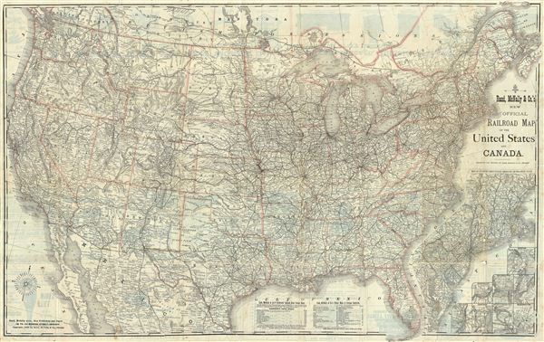
New Official Railroad Map of The United States And Canada.
sold
- Digital Map Information
- Suitable for large format printing
- File Size: 51.94 MB
- File Type: ZIP / TIFF
- ICC color profile embedded
- Delivered instantly via download link
This is a fine example of Rand McNally's 1883 railroad map of the United States. This map covers all of the United States and the southeastern provinces of Canada. Nine inset maps in the lower right quadrant include a map of Atlantic coast states engraved on an ... (more details)
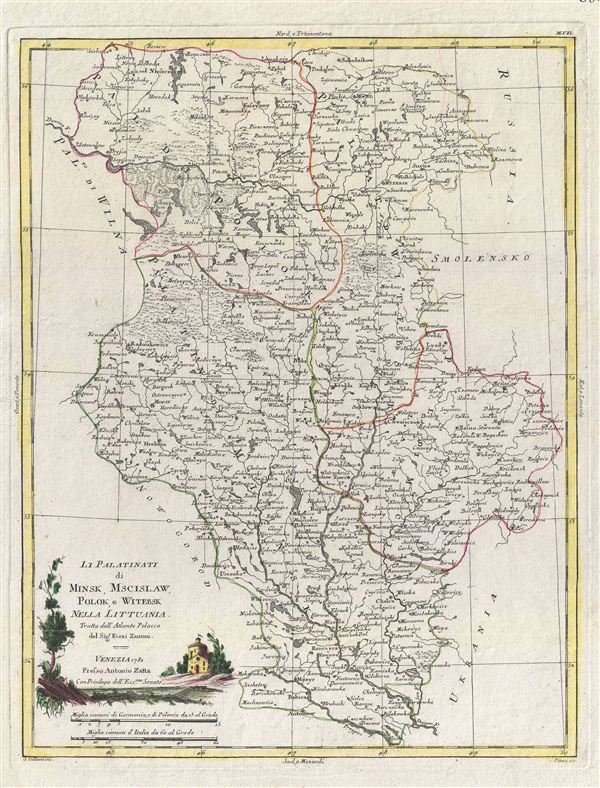
Li Palatinati di Minsk, Mscislaw, Polok, e Witebsk Nella Littuania.
sold
- Digital Map Information
- Suitable for large format printing
- DPI: 300
- File Size: 8.5 MB
- File Type: ZIP / TIFF
- ICC color profile embedded
- Delivered instantly via download link
A fine map of the Palatinates of Minsk, Mscislaw, Polok and Witebsk, Poland. This map covers from parts of Poland from Sokolnikow to Plost and from Wilna to the Russian border. Though culturally intact, by 1781 Poland had gone through two partitions. When ... (more details)
Beautifully engraved map of the Cape of Good Hope showing early Dutch settlers.
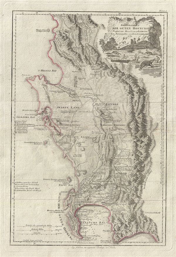
Das Vorgebirg der Guten Hofnung Verfasst von Herrn L.S. de la Rochette Neu Herausgegeben von Herrn. F.A. Schraembl.
sold
- Digital Map Information
- Suitable for large format printing
- DPI: 300
- File Size: 14.19 MB
- File Type: ZIP / TIFF
- ICC color profile embedded
- Delivered instantly via download link
An attractive example of Louis Stanislas d'Arcy Delarochette's important 1789 map of the Cape of Good Hope, South Africa. The map covers from the fictional Klipping Island and St. Helena Bay south as far as False Bay (Valsbaai), Cape Hangklip, and Cape ... (more details)
One of the earliest obtainable views of New York City or, as it was, New Amsterdam.

Novum Amsterodamum.
sold
- Digital Map Information
- Suitable for large format printing
- DPI: 300
- File Size: 3.71 MB
- File Type: ZIP / TIFF
- ICC color profile embedded
- Delivered instantly via download link
A fine example of John Ogilby's 1671 view of New Amsterdam, one of the earliest obtainable depictions of New York City. Prepared for Ogilby's America , this vies is mostly likely based on a very similar watercolor completed by Laurens Hermansz Block ... (more details)
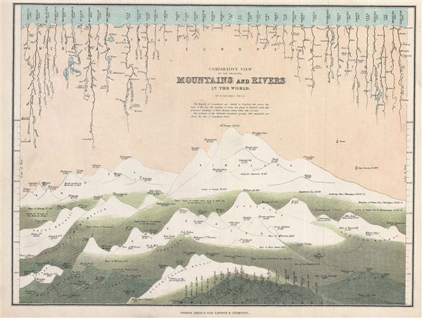
Comparative View of the Principal Mountains and Rivers in the World.
sold
- Digital Map Information
- Suitable for large format printing
- File Size: 3.55 MB
- File Type: ZIP / TIFF
- ICC color profile embedded
- Delivered instantly via download link
This is a fine example of George Philip's 1862 comparative view of the world's principal mountains and rivers. Details the world's great mountains divided according to mountain ranges, Himalayas, Alps, Andes, and so on, while principal rivers are ... (more details)
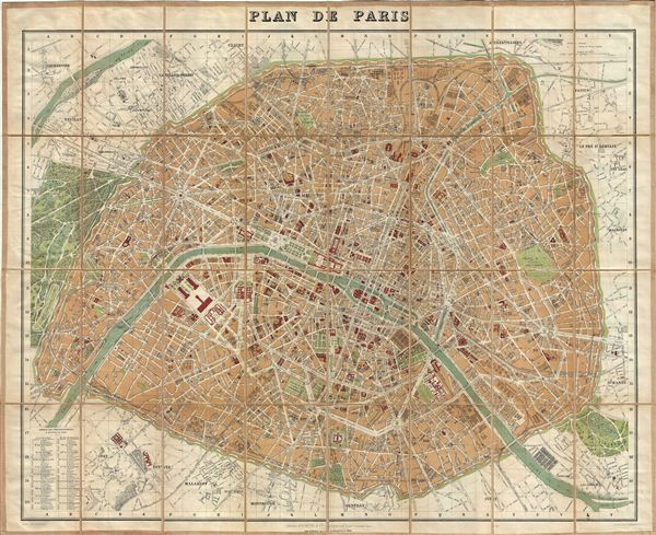
Plan de Paris.
sold
- Digital Map Information
- Suitable for large format printing
- File Size: 38.9 MB
- File Type: ZIP / TIFF
- ICC color profile embedded
- Delivered instantly via download link
A beautiful example of Alexandre Vuillemin's 1891 map or plan of Paris, France. Centered on the Seine River, the map covers the embastilled center of Paris divided into 20 arrondissments. Fine detail is present throughout the map, with important ... (more details)
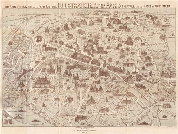
Illustrated Map of Paris Or Stranger's Guide to the Public Buildings, Theatres, Music Halls, and all Places of Amusement.
sold
- Digital Map Information
- Suitable for large format printing
- File Size: 13.56 MB
- File Type: ZIP / TIFF
- ICC color profile embedded
- Delivered instantly via download link
A fine example of G. Warren Bartlett's 1877 pictorial map of Paris, France. Bartlett most likelyisued this map in hopes of capitalizing on tourist traveling to europe for the 1878 exposition Universelle or third Paris World's Fair. Centered on ... (more details)
Uncommon publication by Johns Hopkins University.
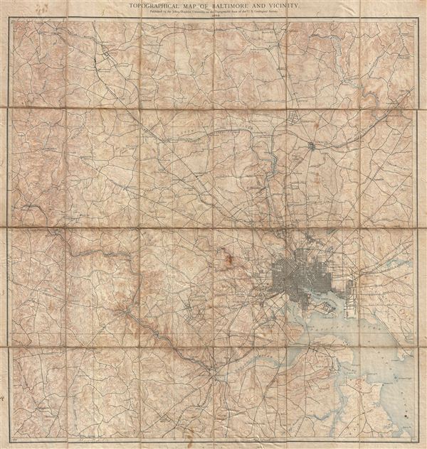
Topographical Map of Baltimore and Vicinity.
sold
- Digital Map Information
- Suitable for large format printing
- File Size: 26.8 MB
- File Type: ZIP / TIFF
- ICC color profile embedded
- Delivered instantly via download link
A rare and unusual discovery. Ostensibly this is a fine example of 1892 U. S. Geological Survey map of Baltimore, Maryland, and vicinity. However, the United States Geological Survey never issued such a map. Instead this an uncommon ... (more details)
Paris at the in the early days of the Belle Époque.

Nouveau Plan de Paris Divise en 20 Arrondissements.
sold
- Digital Map Information
- Suitable for large format printing
- File Size: 34.67 MB
- File Type: ZIP / TIFF
- ICC color profile embedded
- Delivered instantly via download link
This is a highly attractive 1874 Bernadine-Bechet tourist pocket map of Paris, France. This map, based on earlier maps by J. N. Henriot, covers the embastilled center of Paris and the immediate vicinity. The city is divided by color ... (more details)
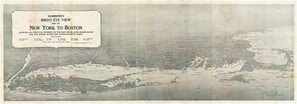
Hammond's Bird's Eye View map of New York to Boston Showign All Points of Interest on the East River, Long Island Sound and the Rhode Island and Massachusetts Coast.
sold
- Digital Map Information
- Suitable for large format printing
- File Size: 1.34 MB
- File Type: ZIP / TIFF
- ICC color profile embedded
- Delivered instantly via download link
This is a fine example of the C. S. Hammond's 1920 bird's eye view map of New York to Boston. Focusing mainly on Long Island, the map covers from Richmond (Staten Island) to Cape Cod. Includes Nantucket Island, Block Island and ... (more details)
The earliest known example of this iconic map and view of Paris.
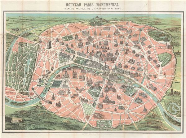
Nouveau Paris Monumental itineraire Pratique de L’Etranger Dans Paris.
sold
- Digital Map Information
- Suitable for large format printing
- File Size: 22.04 MB
- File Type: ZIP / TIFF
- ICC color profile embedded
- Delivered instantly via download link
This is an iconic 1878 tourist pocket map of Paris, France – we believe the earliest example of this map. Presented as a same field birds-eye view, this map centers on the Seine River, and covers the embastilled heart of ... (more details)

Roose's Companion and Guide Map of Washington, and Vicinity.
sold
- Digital Map Information
- Suitable for large format printing
- File Size: 11.92 MB
- File Type: ZIP / TIFF
- ICC color profile embedded
- Delivered instantly via download link
An uncommon map of Washington D.C. dating to 1885 by William Roose. Centered on the Capitol Building, this map covers from Georgetown to the Benning Road Bridge. The map offers a fascinating snapshot of the nation's ... (more details)
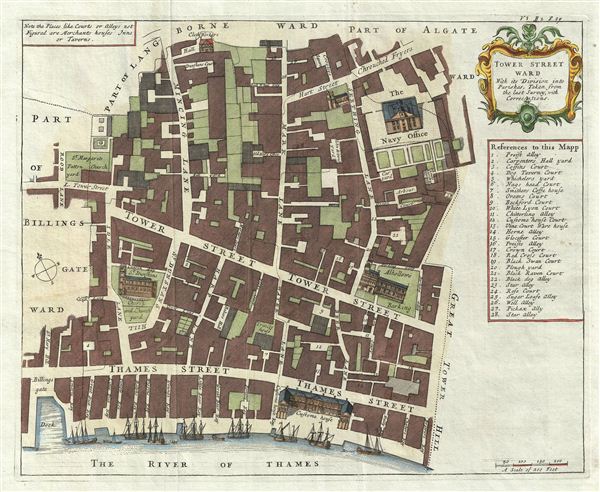
Tower Street Ward With its Division into the Parishes, Taken from the last Survey with Corrections.
sold
- Digital Map Information
- Suitable for large format printing
- DPI: 300
- File Size: 7.65 MB
- File Type: ZIP / TIFF
- ICC color profile embedded
- Delivered instantly via download link
A fine c. 1720 map of the Tower Street Ward, London, england by Richard Blome and John Strype. The map covers the region between and St. Mary's Hill and the Tower of London and from the Clothworkers Hall (still ... (more details)
Unusual map identifying both the 'Sea of Korea' and the 'Sea of Japan'.
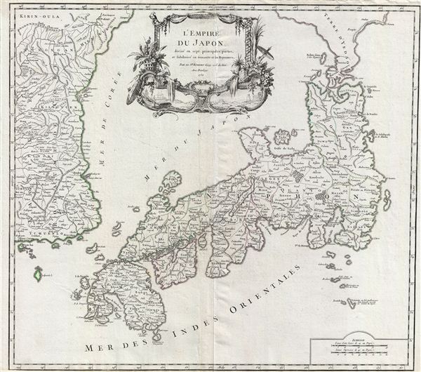
L'Empire du Japon, divise en sept principales parties, et subdivise en soixante et six Royaumes.
sold
- Digital Map Information
- Suitable for large format printing
- Full resolution TIFF file
- ICC color profile embedded
- Delivered instantly via download link
A large and beautiful 1750 map of Japan and Korea by Robert de Vaugondy. Centered on the Bay of Osaka, this map covers from eastern Korea and Ngan-Hai Island eastward to include all of Tokugawa (edo) era Japan. ... (more details)

The 'Standard Guide' Ready Reference Map of Washington to accompany the 'Washington Standard Guide'.
sold
- Digital Map Information
- Suitable for large format printing
- File Size: 21.24 MB
- File Type: ZIP / TIFF
- ICC color profile embedded
- Delivered instantly via download link
An appealing 1932 map of Washington D.C. by Foster and Reynolds Company of New York and B. S. Reynolds Company of Washington. This map covers Washington D.C. from the Arlington National Cemetery eastward as far ... (more details)
Magnificent decorative map of the Holy Land showing the Exodus.
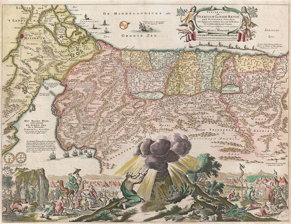
Perigrinatie ofte Veertich-Iarige Reyse der Kinderen Israels
sold
- Digital Map Information
- Suitable for large format printing
- Full resolution TIFF file
- ICC color profile embedded
- Delivered instantly via download link
An absolutely stunning 1682 first state of Keur and Stoopendaal's map of the Holy Land, Israel, or Palestine. This map, from Keur's important Dutch Bible of 1687, is oriented to west and covers from the Nile ... (more details)
Shows the 'Fourth Partition of Poland' following the Napoleonic Wars.
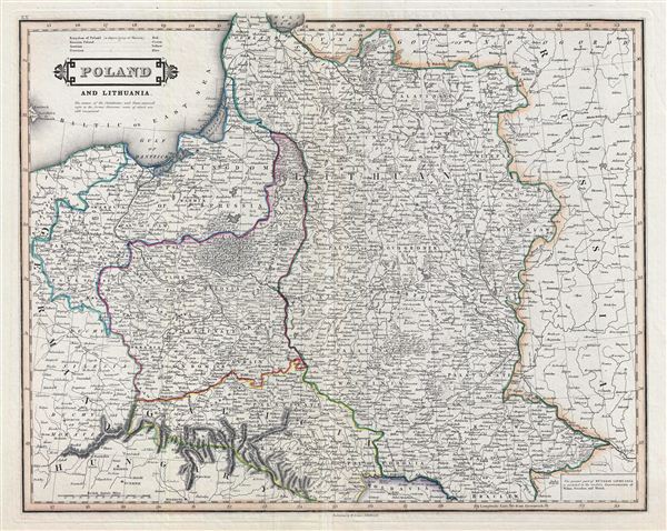
Poland and Lithuania.
sold
- Digital Map Information
- Suitable for large format printing
- Full resolution TIFF file
- ICC color profile embedded
- Delivered instantly via download link
An exceptional example of Daniel Lizars' 1831 map of Poland and Lithuania. Lizars' map covers Poland following Napoleonic Wars and the treaties of the 1815 Congress of Vienna. Twenty earlier, in 1795 The ... (more details)
Shows the 'Fourth Partition of Poland' following the Napoleonic Wars.
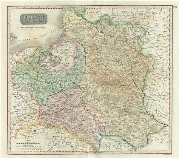
Poland As Divided.
sold
- Digital Map Information
- Suitable for large format printing
- DPI: 300
- File Size: 14.75 MB
- File Type: ZIP / TIFF
- ICC color profile embedded
- Delivered instantly via download link
This is an exceptionally fine example of John Thomson's 1817 map of Poland. Thomson's map covers Poland following Napoleonic Wars and the treaties of the 1815 Congress of Vienna. Twenty earlier, in 1795 ... (more details)
The final map in this series detailing Poland following its dismemberment in the 1785 Third Partition.
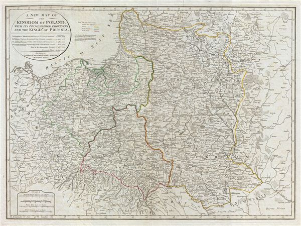
A New Map of the Kingdom of Poland, with its dismembered provinces and the Kingdm. of Prussia.
sold
- Digital Map Information
- Suitable for large format printing
- DPI: 300
- File Size: 21.85 MB
- File Type: ZIP / TIFF
- ICC color profile embedded
- Delivered instantly via download link
This important 1799 map by Laurie and Whittle depicts the Kingdom of Poland following the 1795 Third Partition. The map covers from Brandenburg to Russia and from the Gulf of Livonia to Moldova and ... (more details)
Levasseur's stunning decorative map of North America showing the ephemeral Republic of Texas.

Amerique Septentrionale.
sold
- Digital Map Information
- Suitable for large format printing
- DPI: 300
- File Size: 10.15 MB
- File Type: ZIP / TIFF
- ICC color profile embedded
- Delivered instantly via download link
A visually stunning decorative map of North America dating to 1852, by French map publisher Victor Levasseur. Levasseur published several different editions of his North America map - this being ... (more details)