
Lemercier, Rose-Joseph (sold)
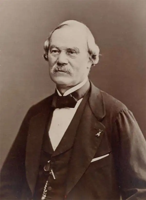
Rose-Joseph Lemercier (June 29, 1803 - 1887) was a French photographer, lithographer, and printer. One of the most important Parisian lithographers of the 19th century, Lemercier was born in Paris into a family of seventeen children. His father was a basket maker, and he even began working as a basket maker at the age of fifteen, but Lemercier was drawn to lithography and printing and soon entered into an apprenticeship with Langlumé, where he worked from 1822 until 1825. After working for a handful of other printers, Lemercier started his own firm in 1828 at 2, rue Pierre Sarrazin with only one printing press. He subsequently moved a few more times before arriving at 57, rue de Seine, where he founded the printing firm Lemercier and Company. He created the firm Lemercier, Bénard and Company in 1837 with Jean François Bénard. Lemercier bought out Bénard's share in the firm in 1843 and, since his two sons died at a young age, he decided to bring his nephew Alfred into the business beginning in 1862, who would progressively take on more and more responsibility in running the firm. Between 1850 and 1870, Lemercier's firm was the largest lithographic company in Paris. The firm began to decline in prestige in the early 1870s, and, after Lemercier's death in 1887, its descent only quickened. It is unclear when the firm closed, but Alfred directed the firm until his death in 1901.
One of the earliest obtainable views of Honolulu.
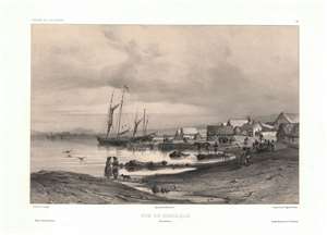
Vue de Honolulu. Iles Sandwich.
sold
- Digital Map Information
- Suitable for large format printing
- Full resolution TIFF file
- ICC color profile embedded
- Delivered instantly via download link
One of the earliest obtainable views of Honolulu, Hawaii, this c. 1840 image was drawn by Barthélemy Lauvergne. Lauvergne was one of several artists accompanying the 1836 - 1837 Auguste-Nicolas Vaillant (1793 - 1858) circumnavigation. The scientific expedition arrived in Hawaii on September 28, 1836 and stayed through October 11. It is safe to assume that Lauvergne sketched this view in early October 1836. The view reveals the ragtag European coastal village set beside the tiny harbor of Kou. Note the European style buildings - as opposed to traditional high roofed Hawaiian thatched structures. Two sailing ships are anchored just offshore. Within 20 years, this small settlement would grow to become the economic hub of the entire north Pacific. In 1850, there are records of more than 100 whaling ships crowding the harbor and 3000 drunken sailors wandering the rough streets in search of … the things for which drunken sailors search. (more details)
The oldest bridge in Paris.
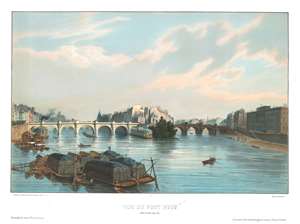
Vue du Pont Neuf.
sold
- Digital Map Information
- Suitable for large format printing
- DPI: 600
- File Size: 11.89 MB
- File Type: ZIP / TIFF
- ICC color profile embedded
- Delivered instantly via download link
This is an 1844 Jules Arnout view of the Pont Neuf in Paris, France. Pont Neuf, the oldest bridge in Paris, connects the left and right banks of the Seine with the Ile de la Cité. Parisians are illustrated crossing the bridge on foot and in carriages, while barges transport goods along the Seine. The buildings of the Ile de la Cité occupy the center of the view, with the square towers of Notre Dame appearing at center and the round towers of the Conciergerie (originally part of the Palais de la Cité) identifiable along the left. (more details)
A beautiful view of the old Hotel de Ville in Paris, before it was burned down at the end of the Paris Commune in 1871.
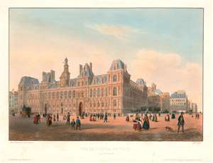
Vue de l'Hôtel de Ville Prise du Quai Pelletier.
sold
- Digital Map Information
- Suitable for large format printing
- DPI: 600
- File Size: 11.1 MB
- File Type: ZIP / TIFF
- ICC color profile embedded
- Delivered instantly via download link
This is an 1844 Jules Arnout view of the Hôtel de Ville (City Hall) in Paris, France. The view, drawn by Arnout from the quai Pelletier (today's quai de Gesvres), illustrates the hôtel de ville as it would have been seen from the Seine. The view details the building's beautiful Renaissance-style façade with Parisians milling about in the square in front going about their daily lives. (more details)
A fine place for an evening stroll...
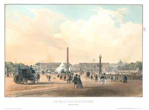
Vue de la Place de la Concorde. Prise du Pont Louis XV.
sold
- Digital Map Information
- Suitable for large format printing
- DPI: 600
- File Size: 12.56 MB
- File Type: ZIP / TIFF
- ICC color profile embedded
- Delivered instantly via download link
This is an 1844 Jules Arnout view of the Place de la Concorde in Paris, France. With the Luxor Obelisk at its center, Parisians are illustrated wandering about the square, which stretches from the Avenue des Champs-Elysées to the Jardin des Tuileries. Ladies are dressed in fine dresses, while most of the men sport coats and top hats. The fountains surrounding the obelisk are illustrated in their finest, while carriages with drivers and footmen try to avoid those walking. The Hôtel de la Marine and its twin, which today houses the Hôtel de Crillon, are depicted in the background, with the Église de la Madeleine visible down the Rue Royale. (more details)
One of the first views of the Madeleine after it was consecrated as a church in 1845.
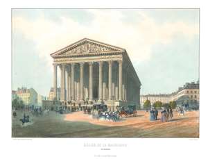
Église de la Madeleine.
sold
- Digital Map Information
- Suitable for large format printing
- Full resolution TIFF file
- ICC color profile embedded
- Delivered instantly via download link
This is a c. 1845 Jean-Baptiste Arnout view of the église de la Madeleine in Paris, France. A beautiful piece, the Madeleine, situated on the Place de la Madeleine in Paris's 8th arrondissement, is illustrated from a slightly off-center perspective, allowing for a lovely illustration of Corinthian columns along the side. Parisians in carriages, on horseback, and on foot traverse the Place de la Madeleine and numerous individuals climb the steps into the church. The history of the Madeleine is one that encapsulates the many political changes in France during the late 18th and early 19th centuries. (more details)
A beautiful view of Les Invalides in Paris, a complex of military buildings in the center of the city with an iconic dome.
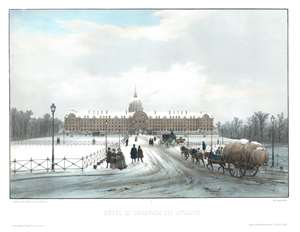
Hôtel et Esplanade des Invalides.
sold
- Digital Map Information
- Suitable for large format printing
- DPI: 600
- File Size: 13.23 MB
- File Type: ZIP / TIFF
- ICC color profile embedded
- Delivered instantly via download link
This is a c. 1845 Jules Arnout view of Les Invalides in Paris, France. Looking south across the Esplanade des Invalides, the view depicts the north façade of the Hôtel des Invalides, with Bruant's door and arched pediment easily recognizable below Hardouin-Mansart's chapel dome. Drawn after a snowfall in Paris, snow blankets the esplanade and the façade and dome of Les Invalides. A horse drawn cart moves slowly up the esplanade in the foreground, with several carriages evident further in the background. Wheel tracks weave their way through the slushy street, which are apparently well traveled since the sidewalks are still blanketed in a fresh snow. Also, pairs and small groups of people are illustrated wandering their way through the neighborhood. (more details)
A view of Notre Dame before its 19th century restoration project undertaken by French architect Eugène Emmanuel Viollet-le-Duc and the construction of its iconic spire.
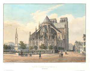
Vue de l'Abside de Notre-Dame et de nouvelle fontaine.
sold
- Digital Map Information
- Suitable for large format printing
- DPI: 600
- File Size: 15.75 MB
- File Type: ZIP / TIFF
- ICC color profile embedded
- Delivered instantly via download link
This is a c. 1845 Jules Arnout view of the apse and east end of Notre Dame Cathedral in Paris, France. Notre Dame dominates the view, with its flying buttresses and the beautiful stained-glass windows of the apse, notably without its iconic spire (which had not yet been built). The Square Jean XXIII and the brand-new Fontaine de la Vierge (Fountain of the Virgin) are situated in the foreground, with several groups of children playing the park (the first of its kind in the neighborhood) and gentlemen in top hats wandering the streets and through the garden. Notre Dame's transept is illustrated, and the tops of its iconic towers are visible just over the transept's roof. (more details)
Striking view of an iconic symbol of France.
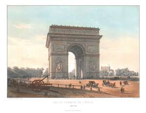
Arc de Triomphe de l'Étoile. Côté de Paris.
sold
- Digital Map Information
- Suitable for large format printing
- Full resolution TIFF file
- ICC color profile embedded
- Delivered instantly via download link
This is a c. 1845 Jules Arnout view of the Arc de Triomphe in Paris, France. Illustrating Arc facing the Champs-Élysées slightly from the left, one can almost discern the left side of the Arc, along with part of the interior. La Départ de 1792 and Le Triomphe de 1810 are the two sculptural groups on the Arc's pillars seen here, along with the three of the six reliefs engraved on this side. (more details)
A beautiful 19th century view of Notre Dame Cathedral in Paris, a world-renowned heritage site.
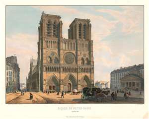
Façade de Notre-Dame et Hôtel-Dieu
sold
- Digital Map Information
- Suitable for large format printing
- DPI: 600
- File Size: 15.07 MB
- File Type: ZIP / TIFF
- ICC color profile embedded
- Delivered instantly via download link
This is a c. 1845 Jules Arnout view of the façade of Notre Dame Cathedral in Paris. The view depicts the front of Notre Dame from the left, with the entire left side of the cathedral illustrated along the street that ran parallel it. A large group of people are illustrated entering the cathedral through the door on the left and others are shown milling about in the square in front of Notre Dame, going about their daily lives. Two carriages are parked in front of the cathedral. The cathedral's two stunning towers rise high above the square, surveying the goings-on much as they had for centuries. The iconic rose window is beautifully drawn in as much detail as was possible, as is the entire façade. The Hôtel-Dieu hospital, the oldest hospital in Paris, is depicted on the right side of the view, with a large crowd of people climbing its steps. (more details)
A beautiful color view of a Parisian palace that was burned during the French Commune.
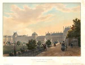
Vue du Palais des Tuileries prise du bas de al terrasse du bord de l'eau.
sold
- Digital Map Information
- Suitable for large format printing
- DPI: 600
- File Size: 15.16 MB
- File Type: ZIP / TIFF
- ICC color profile embedded
- Delivered instantly via download link
This is a c. 1845 Jules Arnout view of the Palais des Tuileries in Paris, France. The Palais des Tuileries was a French royal palace located in Paris located between the Jardin des Tuileries (Tuileries Gardens) and the Jardin du Carrousel along today's Avenue du Général Lemonnier and was attached to the Louvre. The view, drawn from the Jardin des Tuileries, illustrates Parisians going about their day and enjoying the beauty of the gardens. Marble statuary are placed throughout the garden, and numerous flowers are in bloom. (more details)
A beautiful Paris palace burned during the Paris Commune.
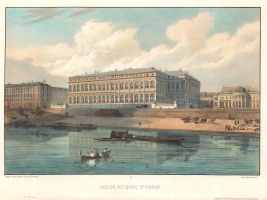
Palais du Quai d'Orsay.
sold
- Digital Map Information
- Suitable for large format printing
- DPI: 600
- File Size: 28.63 MB
- File Type: ZIP / TIFF
- ICC color profile embedded
- Delivered instantly via download link
Completed only five years before this view was published, this is an 1845 Jules Arnout view of the Palais du Quai d'Orsay in Paris, France. The Palais du Quai d'Orsay occupies the center, with the Palais de la Légion d'Honneur to its right. The Quai runs along the river and workers appear along the banks of the Seine. Riverboats and canoes ply the waters of the Seine and a group of male revelers swim in the river and drink in their rowboat in the foreground. (more details)
A beautiful 19th century view of the Jardin du Luxembourg and the Palais du Luxembourg - with families sailing ships on the basin just as they do today!
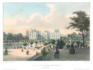
Palais de la Chambre des Pairs. Vue Prise du Jardin.
sold
- Digital Map Information
- Suitable for large format printing
- DPI: 600
- File Size: 12.24 MB
- File Type: ZIP / TIFF
- ICC color profile embedded
- Delivered instantly via download link
This is an 1845 Jules Arnout view of the Palais du Luxembourg and the Jardin du Luxembourg in Paris, France. The view overlooks the park from the southeast, with the basin in the foreground and the Palais du Luxembourg, the seat of the French Senate, dominating the view and acting as the main focal point. Small trees and shrubs line the paths, and young boys and their families play with boats on the basin, just as children do to this day. The bell towers of the Saint-Sulpice Church can be seen in the background. (more details)
A wonderful view of the Panthéon in Paris - France's tribute to its most famous citizens.
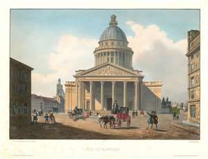
Vue du Panthéon.
sold
- Digital Map Information
- Suitable for large format printing
- DPI: 600
- File Size: 14.63 MB
- File Type: ZIP / TIFF
- ICC color profile embedded
- Delivered instantly via download link
This is a c. 1845 Jules Arnout view of the Panthéon in Paris, France. The Panthéon, located in the Latin Quarter in the 5th arrondissement, was originally built as a church dedicated to St. Genevieve with the express purpose of houses the reliquary châsse containing her relics. The building was designed after a Greek cross with a massive portico inspired by the Pantheon in Rome. Construction on the Abbey of St. Genevieve, the patron saint of Paris, was completed in 1790. This, however, changed in 1791 during the French Revolution when the National Constituent Assembly declared that the Panthéon would be converted into a mausoleum for the internment of great Frenchmen. This secular monument has changed by to beig a church a handful of times, but today it plays the role of the burial place for French 'national heroes', some of whom include Voltaire, Rousseau, Alexandre Dumas, Jean Moulin, André Malraux, and Simone and Antoine Veil. (more details)
A view of the Palais des Tuileries, a royal and imperial residence in Paris that was destroyed by the Paris Commune in 1871.
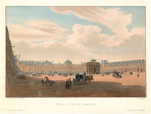
Vue de la Place du Carrousel.
sold
- Digital Map Information
- Suitable for large format printing
- DPI: 600
- File Size: 12.83 MB
- File Type: ZIP / TIFF
- ICC color profile embedded
- Delivered instantly via download link
This is a c. 1845 Jules Arnout view of the Place du Carrousel and the Palais des Tuileries (Tuileries Palace) in Paris, France. The view illustrates the Place du Carrousel from the east and depicts a typical day in Paris. Parisians rush across the square, on foot, on horseback, and in carriages. All this activity takes place in the shadow of the Arc de Triomphe du Carrousel, constructed to commemorate Napoleon's military victories between 1806 and 1808. Based on the Arch of Constantine in Rome, the Arc de Triomphe du Carrousel is topped by the Horses of Saint Mark from Saint Mark's Cathedral in Venice, which were brought to Paris by Napoleon in 1798 after he captured Venice. Behind the Arc de Triomphe du Carrousel stands the Palais de Tuileries. This palace was the main royal residence for French monarchs from Henry IV through Napoleon III until it was burned down by the Paris Commune in 1871. The Palais des Tuileries was never rebuilt, although a campaign advocating for its reconstruction has been ongoing since 2003. (more details)
The Vendôme Column before it was toppled during the Paris Commune.
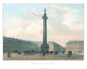
Colonne de la Place Vendôme.
sold
- Digital Map Information
- Suitable for large format printing
- Full resolution TIFF file
- ICC color profile embedded
- Delivered instantly via download link
This is a c. 1845 Jules Arnout view of the Vendôme Column (Colonne Vendôme) in the Place Vendôme in Paris, France. From the front, the statue of Napoleon in a military officer's coat adorning the top of the column is clearly visible. While not legible, the detailed relief work on the column is evident. Parisians promenade through the square on foot and in horse-drawn carriages. The buildings surrounding the north side of the square appear in the background. (more details)
Monument to Captain James Cook in Hawaii, visited by a later expedition.
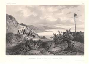
Monument élevé à Hawaii au Capitaine Cook, Iles Sandwich / [Monument raised in Hawaii to Captain Cook, Sandwich Islands].
sold
- Digital Map Information
- Suitable for large format printing
- Full resolution TIFF file
- ICC color profile embedded
- Delivered instantly via download link
This is a c. 1845 lithograph view of Kealakekua Bay, Hawaii (Sandwich Islands) illustrating a memorial to Captain James Cook, erected roughly where he was killed in 1779. The view was sketched by Théodore Auguste Fisquet, one of the resident artists on the Bonite expedition, a French scientific and diplomatic voyage around the world in 1836 - 1837. (more details)
One of the earliest obtainable views of Singapore.
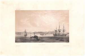
Vue de Sincapour.
sold
- Digital Map Information
- Suitable for large format printing
- DPI: 600
- File Size: 26.17 MB
- File Type: ZIP / TIFF
- ICC color profile embedded
- Delivered instantly via download link
One of the earliest obtainable views of Singapore, this is a rare c. 1845 chromolithograph by Barthélémy Lauvergne, one of the resident artists on the Bonite Expedition (1836 - 1837), a French scientific and diplomatic circumnavigation. It presents the British colony in its early days of development as a bustling port and meeting point of cultures. (more details)
View of Kealakekua and Kealakekua Bay, important sites in Native Hawaiian culture.
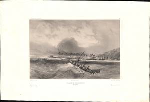
Village De Kearakekoua / [Kealakekua Village].
sold
- Digital Map Information
- Suitable for large format printing
- Full resolution TIFF file
- ICC color profile embedded
- Delivered instantly via download link
This is a c. 1845 lithograph view of the village of Kealakekua, Hawaii (Sandwich Islands) showing two groups of indigenous inhabitants in canoes with the village in the background. The view was sketched by Barthélémy Lauvergne, one of the resident artists on the Bonite expedition, a French scientific and diplomatic voyage around the world in 1836 - 1837. (more details)
New York emerges as the equal of London or Paris!
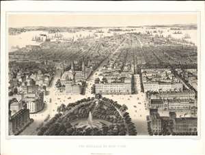
Vue Générale de New-York.
sold
- Digital Map Information
- Suitable for large format printing
- Full resolution TIFF file
- ICC color profile embedded
- Delivered instantly via download link
This is a spectacular 2-color chromolithograph bird's-eye view of New York City by C. Wild, H. Walter, and Lemercier. The work represents New York as it attempted to establish itself as a premier global metropolis, comparable to London and Paris. The view looks south towards New York Harbor from a fictional high-point above Union Square (14th - 18th Sts.). The city's primary arteries, Broadway, University Place, and 4th Avenue are exaggerated in their width, giving them the aspect of broad Parisian-style boulevards. The foreground is occupied by Union Square itself, with its dramatic fountain, surrounded by impressive European style architecture. (more details)
Hydrographic projects on the River Nile, and the Prospective Suez Canal.
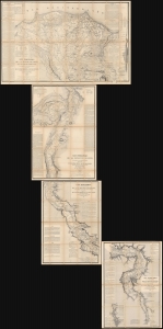
Carte Hydrographique de la Basse Égypte/ Carte Hydrographique de la Moyenne Égypte/Carte Hydrographique de la Partie Septentrionale de la Haute Egypte/ Carte Hydrographique de la Partie Méridionale de la Haute Egypte.
sold
This is a set of four large, superbly detailed maps of Egypt by Linant de Bellefonds, detailing the course of the River Nile and the prospective routes of the Suez Canal. The four maps are on a uniform scale and were sold a group by Paris mapseller Lanée, to American congregationalist preacher and professor Roswell Dwight Hitchcock, probably in 1869 in preparation for that avid traveler's 1870 visit to Egypt. These were easily the most detailed maps to cover the Egyptian Nile available at that time, and their rich detail of ancient and reference to Biblical monuments would have been compelling. Taken together, the maps illuminate the Nile continuously from the Mediterranean Sea to the cataracts upstream of Aswan. (more details)
Illustrates Notre Dame, the Louvre, and the Madeleine, among many other Parisian landmarks.
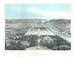
Vue Générale de Paris. Prise du Rond-Point.
sold
- Digital Map Information
- Suitable for large format printing
- File Size: 20.33 MB
- File Type: ZIP / TIFF
- ICC color profile embedded
- Delivered instantly via download link
This is a c. 1855 Michel Charles Fichot bird's eye view of Paris, France. Illustrated from above the Jardin des Champs-Elysées, the view depicts Paris from the east. The Jardin des Champs-Elysées is illustrated in the foreground with the Cirque d'Été to the left of center and the Palace of Industry from the 1855 Paris Universal Exposition, the Rotonde des Panoramas aux Champs-Elysées, and the Annex for the Palace of Industry on the right. Further on, the viewer encounters the Place de la Concorde, the Jardin des Tuileries, the Palais des Tuileries and the Palais du Louvre. Other Paris landmarks illustrated in the view include the Palais Bourbon, the Église de la Madeleine, the Panthéon de Paris, Notre Dame Cathedral, the Hôtel de Ville, and the Luxembourg Palace. (more details)
Establishment of the Cru System.
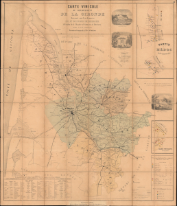
Carte Vinicole du Département de la Gironde dressée sur les données de Mr. Duffour Dubergier President de la Chambre de Commerce de Bordeaux par Unal Serres Dessinateur Géomètre de la Ville Bordeaux.
sold
- Digital Map Information
- Suitable for large format printing
- File Size: 66.01 MB
- File Type: ZIP / TIFF
- ICC color profile embedded
- Delivered instantly via download link
This is an important 1859 Unal Serres and Dubergier thematic map of Bordeaux's (Gironde) official wine, following the Cru System established by the Bordeaux Wine Official Classification of 1855. The map thus illustrates a pivotal moment in the development of global wine ranking models that retains enduring relevance. This is the first map to focus on wine classification. (more details)
Paris after the Haussmann Renovations at the height of the Second Empire.
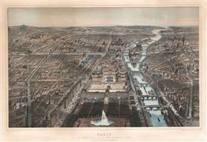
Paris Vue Générale Prise au Dessus de L'Entrée du Jardin ds Tuileries Le Nouveau Louvre, La Rue de Rivoli et Les boulevards.
sold
- Digital Map Information
- Suitable for large format printing
- File Size: 120.04 MB
- File Type: ZIP / TIFF
- ICC color profile embedded
- Delivered instantly via download link
An utterly captivating 1867 large-format lithograph view of Paris by Michel-Charles Fichot and Rose-Joseph Lemercier. The view looks southwest on Paris from hypothetical position above the Bassin Octagonal in the Jardin des Tuileries. The Louvre appears front and center, with the Rue de Rivoli on its left and the Seine on tis right. Notre Dame and the Ile de Cité, the Hôtel de Ville, Tour St. Jacques, and other monuments are apparent. (more details)
Building the Suez Canal.
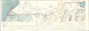
Percement de L'Isthme de Suez. / [Suez Canal.]
sold
- Digital Map Information
- Suitable for large format printing
- File Size: 17.77 MB
- File Type: ZIP / TIFF
- ICC color profile embedded
- Delivered instantly via download link
This is a dramatic large map of the Suez Canal, Egypt, issued in 1868, a year before the canal opened to commercial traffic. The map accompanies a scarce publication by L. Barreau, a French civil engineer based in Alexandria, describing the monumental undertaking. (more details)
First cartographic reconnaissance of the Chao Phraya River.
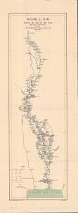
Royaume de Siam Cours du fleuve Me-Nam (Mè Năm Chào Phăja).
sold
- Digital Map Information
- Suitable for large format printing
- File Size: 13.53 MB
- File Type: ZIP / TIFF
- ICC color profile embedded
- Delivered instantly via download link
An important 1879 Émile Lombard missionary map of the Chao Phraya River, Thailand (Siam). It is significant as the first major upgrade to Siamese inland cartography since the 1828 John Crawfurd Map (SoutheastAsiaSiam-crawfurdwalker-1828-3). It is the first map to accurately identify towns and villages along the Chao Phraya, and the first we are aware of to use the term 'Chao Phraya'. It is of note that, while in most cases we would emphasize this work as the 'first European mapping' of the region, in this case, indigenous Siamese mapmaking is extremely limited and practically unknown until the 20th century, so this work marks the first time most of these villages appeared in any cartographic context. (more details)
Eyeing a colonial empire in French Indochina.
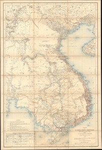
Carte de l'Indo-Chine Orientale.
sold
- Digital Map Information
- Suitable for large format printing
- File Size: 51.45 MB
- File Type: ZIP / TIFF
- ICC color profile embedded
- Delivered instantly via download link
This is an 1881 Jules-Léon Dutreuil de Rhins map of eastern Indochina (Vietnam, Laos, Cambodia, and part of Thailand) - window into French colonial intervention in Southeast Asia. This map was published 6 years before French Indochina was formally established but underscores growing French interest and investment in Indochina. (more details)