
Rand, Avery, and Company (sold)

Rand, Avery, and Company (1851 – 1886) was a Boston based book and map printer active in the late 19th century. The company was founded in 1851 by George Curtis Rand (December 13, 1819 – December 30, 1878) and his brother-in-law Abraham Avery (November 15, 1824 - April 3, 1893). George C. Rand was a brother to William H. Rand of Rand, McNally, and Company of Chicago. George C. Rand was born in Woodstock, Vermont, to Baptist minister John Rand (1781 – 1855) and his wife. Rand began working in the printing industry from at least the 1840s, wherein he mostly produced religious tracts. He married Julia Avery in 1851 and brought his brother-in-law, Abraham Avery, into the business, renaming the firm Rand, Avery, and Company. Avery was born in Wibraham, Massachusetts and studied at Wesleyan University, which his father helped to found. Rand, Avery, and Company was based in Cornhill, Boston, and was, for a time, they were the largest printers in New England. Such works as Uncle Tom's Cabin were included in their catalog. Avery retired when Rand died in 1878, but the firm continued to publish under another generation of managers, including Rand's son, Avery L. Rand, until at least 1886. They also took on a fourth partner, Orrin F. Frye, and published as Rand, Avery, and Frye. After retiring Avery moved to Los Angeles where he died in 1893. It appears that this firm also published under the name the Rand Avery Supply Company.
Earliest Railroad on the North Shore of Massachusetts.
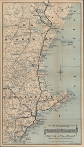
Sea Coast Map of the Eastern Railroad from Boston to York Beach.
sold
- Digital Map Information
- Suitable for large format printing
- File Size: 14.37 MB
- File Type: ZIP / TIFF
- ICC color profile embedded
- Delivered instantly via download link
A scarce c. 1880 map of the Eastern Railroad in the coastal region of Massachusetts, New Hampshire, and Maine, issued by Rand Avery Supply of Boston for the railroad's Passenger Department. (more details)
A rare railroad map of Florida and the beginning of the Plant System of railroads.
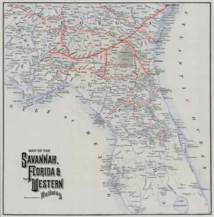
Map of the Savannah, Florida, and Western Railway.
sold
- Digital Map Information
- Suitable for large format printing
- File Size: 10.47 MB
- File Type: ZIP / TIFF
- ICC color profile embedded
- Delivered instantly via download link
This is an 1882 Rand Avery railroad map of Florida and Georgia. Depicting the region from Savannah to Lake Okeechobee and from St. Andrews Bay to the Atlantic Ocean, thick red lines highlight the Savannah, Florida, and Western Railway. Thinner red lines trace the routes of connecting railways, including the Brunswick and Albany Railroad; the Jacksonville, Pensacola, and Mobile Florida Central Railroad; and the Florida Transit Railroad. Two short railroads are illustrated and labeled in central Florida, one of which is identified at the Southern Florida Railroad. (more details)
Bird's-eye view of the White Mountains advertising railroads.
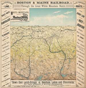
Bird's-Eye Map of the White Mountains by Boston and Maine.
sold
- Digital Map Information
- Suitable for large format printing
- File Size: 13.25 MB
- File Type: ZIP / TIFF
- ICC color profile embedded
- Delivered instantly via download link
This is an 1887 Boston and Maine Railroad bird's eye view map of the White Mountains promoting their service in the area to tourists. The view depicts the region from St. Johnsbury and East Haverhill to Shelburne, Chatham, and Conway Center and from Lancaster and Jefferson Mills to Plymouth and Squam Lake. Beautifully engraved, every mountain in the region is labeled and its elevation is given. Myriad cities, towns, and villages are identified, along with rivers, ponds, and lakes. Railroad routes in the region, including those of the Boston and Maine Railroad and the Maine Central Railroad, are illustrated by thick black lines. The whole is framed by text advertising the Merrimack Valley Route and the Seashore Route operated by the Boston and Maine Railroad to the White Mountains. In the lower right corner of the advertising surround, a short text promotes 'elegant new Pullman Buffet Cars. At the end of the 19th century, Pullman cars were considered the height of luxury and would have been enticing to potential travelers. (more details)
Boston and Maine Railroad's routes around Cape Ann.
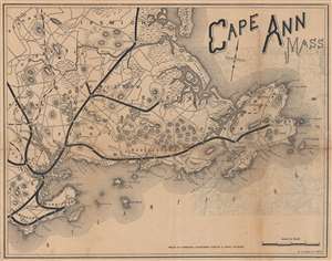
Cape Ann Mass.
sold
- Digital Map Information
- Suitable for large format printing
- File Size: 9.18 MB
- File Type: ZIP / TIFF
- ICC color profile embedded
- Delivered instantly via download link
This is an 1889 Rand Avery Supply Company map of Cape Ann, Massachusetts. Issued by the Passenger Department of the Boston and Maine Railroad, thick black lines trace the Boston and Maine Railroad's network through the region, including the Eastern Division spurs to Marblehead and Rockport. The only cities and towns labeled are those serviced by the Boston and Maine. However, the region's counties, rivers, ponds, and lakes are all illustrated and labeled. The coastline is also depicted in detail, with Salem Harbor and Beverly Harbor identified, along with innumerable points and coves. (more details)
One of the last maps of the Old Colony Railroad.
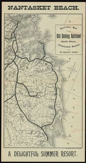
Sectional Map of the Old Colony Railroad South Shore, Nantasket Beach and Plymouth Lines. Nantasket Beach A Delightful Summer Resort.
sold
- Digital Map Information
- Suitable for large format printing
- File Size: 10.15 MB
- File Type: ZIP / TIFF
- ICC color profile embedded
- Delivered instantly via download link
An 1890 Old Colony Railroad tourist map of southeastern Massachusetts published only a few years before its acquisition by the New York, New Haven, and Hartford Railroad. Old Colony promotes its South Shore, Nantasket Beach, and Plymouth Lines, all of which were popular with Bostonians trying to escape the summer heat. The rail lines are emphasized in black and many stops are noted, including Nantasket, Braintree, Kingston, and Plymouth. (more details)
A bird's-eye view of the White Mountains advertising rail service in the region.
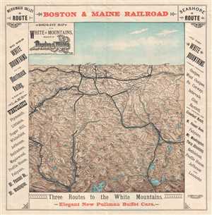
Bird's Eye Map of the White Mountains Reached by Boston and Maine Railroad.
sold
- Digital Map Information
- Suitable for large format printing
- File Size: 6.62 MB
- File Type: ZIP / TIFF
- ICC color profile embedded
- Delivered instantly via download link
This is an 1896 Boston and Maine Railroad bird's eye view map of the White Mountains promoting their service in the area to tourists. The view depicts the region from St. Johnsbury and East Haverhill to Shelburne, Chatham, and Conway Center and from Lancaster and Jefferson Mills to Plymouth and Squam Lake. Beautifully engraved, every mountain in the region is labeled and its elevation is given. Myriad cities, towns, and villages are identified, along with rivers, ponds, and lakes. Railroad routes in the region, including those of the Boston and Maine Railroad and the Maine Central Railroad, are illustrated by thick black lines. The whole is framed by text advertising the Merrimack Valley Route and the Seashore Route operated by the Boston and Maine Railroad to the White Mountains. Red text along the bottom border highlights to new arrival of Pullman buffet cars. At the time, Pullman cars were synonymous with the highest standards of luxury travel. (more details)
A bird's-eye view of the White Mountains advertising rail service in the region.
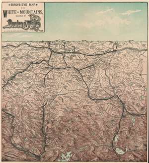
Bird's Eye Map of the White Mountains Reached by Boston and Maine Railroad.
sold
- Digital Map Information
- Suitable for large format printing
- File Size: 11.53 MB
- File Type: ZIP / TIFF
- ICC color profile embedded
- Delivered instantly via download link
This is an 1896 Boston and Maine Railroad bird's eye view map of the White Mountains promoting their service in the area to tourists. The view depicts the region from St. Johnsbury and East Haverhill to Shelburne, Chatham, and Conway Center and from Lancaster and Jefferson Mills to Plymouth and Squam Lake. Beautifully engraved, every mountain in the region is labeled and its elevation is given. Railroad routes in the region, including those of the Boston and Maine Railroad and the Maine Central Railroad, are illustrated by thick black lines. (more details)
Bird's-eye view of the White Mountains advertising rail service.
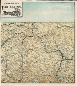
Bird's Eye Map of the White Mountains Reached by Boston and Maine Railroad.
sold
- Digital Map Information
- Suitable for large format printing
- File Size: 10.36 MB
- File Type: ZIP / TIFF
- ICC color profile embedded
- Delivered instantly via download link
This is an 1896 Boston and Maine Railroad bird's-eye view map of the White Mountains promoting their service to tourists. (more details)
Guide for Maine / New Hampshire outdoorsmen.
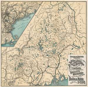
Fishing and Hunting Resorts of Maine, Northern New Hampshire, and Part of Canada and the Provinces, Rangeley and Moosehead Lakes as Reached by the Boston and Maine Railroad and Connections.
sold
- Digital Map Information
- Suitable for large format printing
- File Size: 15.78 MB
- File Type: ZIP / TIFF
- ICC color profile embedded
- Delivered instantly via download link
This is an 1899 Rand Avery Supply Company and Boston and Maine Railroad map of Maine and northern New Hampshire. Depicting the region from the White Mountains northeast to New Brunswick, thick black lines trace the Maine Central Railroad's route. Less imposing black lines illustrate the region's other railroads, including the 'Canadian Pacific Railroad' and the 'Bangor and Aroostook Railroad'. Maine's many lakes, such as Moosehead Lake, Chamberlain Lake, the Eagle Lakes, and Grand Lake, are illustrated and labeled, along with the region's many rivers. Houses, hotels, and other properties catering to outdoor sports enthusiasts are identified, although they are not emphasized. An inset in the upper left promotes the railway network between Boston and Vanceboro, Maine, with spur service to the Mount Desert Island Ferry and numerous lines running through the White Mountains. (more details)
Home to Memphre, a cryptid akin to the Loch Ness Monster.
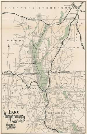
Lake Memphremagog and About There.
sold
- Digital Map Information
- Suitable for large format printing
- File Size: 8.9 MB
- File Type: ZIP / TIFF
- ICC color profile embedded
- Delivered instantly via download link
This is an 1899 Rand Avery Supply Company and Boston and Maine Railroad map of Lake Memphremagog. Lake Memphremagog stretches across the U.S.-Canada border between Newport, Vermont and Magog, Quebec, Canada. Thick black lines trace the Boston and Maine Railroad's lines in the area, as well as the Canadian Pacific Railway. Roads throughout are illustrated. Towns identified include Magog, Sherbrooke, and Newport. The Owls Head Hotel, a ski resort today, is prominently identified. (more details)
Popular New Hampshire tourist destination at the turn of the century.
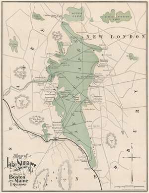
Map of Lake Sunapee and Vicinity Reached by Boston and Maine Railroad.
sold
- Digital Map Information
- Suitable for large format printing
- File Size: 10.56 MB
- File Type: ZIP / TIFF
- ICC color profile embedded
- Delivered instantly via download link
This is an 1899 Rand Avery Supply Company and Boston and Maine Railroad map of Lake Sunapee, New Hampshire. Rail service to Lake Sunapee from Boston was completed in 1854, long before the advent of the automobile. This event almost immediately made the lake and its surrounding towns a vacation destination for urbanites. Lodges, homes, hotels, boat ramps, businesses, train stations, and other important tourist infrastructure quickly followed. A solid black line in the bottom left illustrates the Boston and Maine's route. (more details)
The largest lake in New Hampshire.
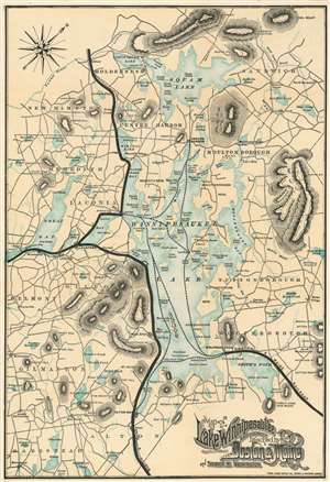
Map of Lake Winnipesaukee and Vicinity Reached by Boston and Maine R.R. and Steamer Mt. Washington.
sold
- Digital Map Information
- Suitable for large format printing
- File Size: 13.52 MB
- File Type: ZIP / TIFF
- ICC color profile embedded
- Delivered instantly via download link
This is an 1899 Rand Avery Supply Company and Boston and Maine Railroad map of Lake Winnipesaukee. Lake Winnipesaukee - in Abenaki 'smile of the Great Spirit' or 'beautiful water in a high place' - is the largest lake in New Hampshire and a popular resort area. Thick black lines trace the Boston and Maine Railroad's lines throughout. Dashed lines follow the course of the MS Mount Washington, a mail steamer operated by the Boston and Maine from 1872. The rival Eastern Railroad extended its services into Wolfeboro (Wolfeborough) in 1872. We speculate: given that the Boston and Maine started operating the MS Mount Washington that year, it is likely that the Boston and Maine leased the trackage from Eastern pending formal acquisition of the railroad in 1884. (more details)
Jacksonville to Miami on the Florida East Coast Railway!
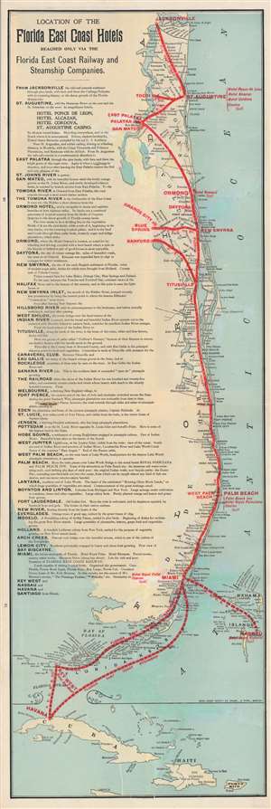
Location of the Florida East Coast Hotels Reached Only Via the Florida East Coast Railway and Steamship Companies.
sold
- Digital Map Information
- Suitable for large format printing
- File Size: 8.05 MB
- File Type: ZIP / TIFF
- ICC color profile embedded
- Delivered instantly via download link
This is a 1900 Rand Avery map of Florida's East Coast, its railway network, and its resort hotels. Depicting from Jacksonville south to Puerto Rico and Jamaica, red overprinting highlights the Florida East Coast Railway and the connected Florida East Coast Steamship Company. Major stops along the railway, including Jacksonville, St. Augustine, New Smyrna, Palm Beach, and Miami, are labeled in red. Ports of Call for the steamship company are identified in the same manner, including Key West, Nassau, and Havana. Smaller stops along the railway are identified in black, along with coastal inlets, bays, lakes, and other sites. A narrative recounting high points in cities from Jacksonville to Miami occupies the left half of the map. (more details)
Integration of Rail and Steamer Service.
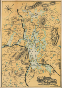
Map of Lake Winnipesaukee and Vicinity Reached by Boston and Maine R.R. and Steamer Mt. Washington.
sold
- Digital Map Information
- Suitable for large format printing
- Full resolution TIFF file
- ICC color profile embedded
- Delivered instantly via download link
This is a 1901 Rand Avery Supply Company map of Lake Winnipesaukee, New Hampshire, and environs, produced for the Boston and Maine Railroad. It reflects the seamless integration of rail and steamer service that the Boston and Maine had perfected by this point, bringing passengers from Boston, New York, and other coastal cities directly to their hotel and resort destinations around the lake. (more details)
Map of Mount Desert Island and the Coast of Maine, home of the Acadia National Park.
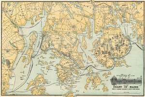
Map of Mount Desert Island and the Coast of Maine.
sold
- Digital Map Information
- Suitable for large format printing
- File Size: 25.79 MB
- File Type: ZIP / TIFF
- ICC color profile embedded
- Delivered instantly via download link
This is an attractive 1902 Rand Avery map of Mount Desert Island and the coast of Maine issued by the Passenger Department of Boston and Maine Railroad. The map depicts Mount Desert Island and vicinity from Lincolnville and Rockland east to Winter Harbor and north as far as Pattens Pond and Verona. Roads and towns are illustrated throughout, and steamship and ferry routes running between several islands are identified, including those of Blue Hill Steamship Co., the Maine Central Railroad ferry, and the Bangor steamers. The railway route to Portland and Boston is also noted. (more details)
Travel to Mount Desert Island via the Eastern Steamship Company.
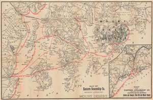
Map of Eastern Steamship Co. Showing Approaches to Mount Desert.
sold
- Digital Map Information
- Suitable for large format printing
- File Size: 45.85 MB
- File Type: ZIP / TIFF
- ICC color profile embedded
- Delivered instantly via download link
This is a 1905 Rand Avery map of Mount Desert Island and coastal Maine illustrating the routes of the Eastern Steamship Company. Red overprinting highlights the routes of the Eastern Steamship Company's steamers to Mount Desert Island, along with its stops at Camden, Rockland, Belfast, and Blue Hill, among others. Roads between towns and post offices are identified. Many coastal islands are illustrated and labeled as well. An inset in the lower right depicts the Eastern Steamship Company's route between Boston and Bangor and Blue Hill and Mount Desert Island, emphasizing fast transit to Mount Desert Island, then a haven for wealthy New England elite. (more details)
Empire of an American scoundrel.
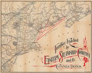
Territory Reached by the Eastern Steamship Company and its Connections.
sold
- Digital Map Information
- Suitable for large format printing
- File Size: 43.21 MB
- File Type: ZIP / TIFF
- ICC color profile embedded
- Delivered instantly via download link
This is a c. 1905 Rand Avery map of New England and the routes of the Eastern Steamship Company. (more details)
An opening of central Maine that never happened.
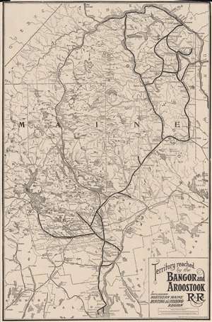
Territory Reached by the Bangor and Aroostook R.R. Including Northern Maine Hunting and Fishing Region.
sold
- Digital Map Information
- Suitable for large format printing
- File Size: 19.76 MB
- File Type: ZIP / TIFF
- ICC color profile embedded
- Delivered instantly via download link
This is a c. 1910 Rand Avery railroad map of Maine highlighting the Bangor and Aroostook Railroad. Covering from Belfast to Canada, a solid black line traces the Bangor and Aroostook route. Cities, towns, and villages along the route are labeled, including the then closed Katahdin Iron Works. (The iron works closed in 1890.) Thin black lines follow the routes of the Maine Central Railroad and the Canadian Pacific Railroad. Lakes of varying size appear throughout, including Moosehead Lake near the left border. (more details)
Ephemeral record of the Massachusetts Interurban Trolley System.
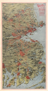
AeroView Map Showing Territory Covered by the Lines of the Bay State Street Railway Co. and Their Connections.
sold
- Digital Map Information
- Suitable for large format printing
- Full resolution TIFF file
- ICC color profile embedded
- Delivered instantly via download link
This is a 1912 Rand Avery view and map of eastern Massachusetts illustrating the Bay State Street Railway Company's interurban trolley network. This is an ephemeral piece, the Bay State Street Railway Company existed for only 6 years before it went bankrupt and bought out. It is thus a rare record of the delcine of the New England interurban trolley. (more details)