
Europe after the Franco-Prussian War.
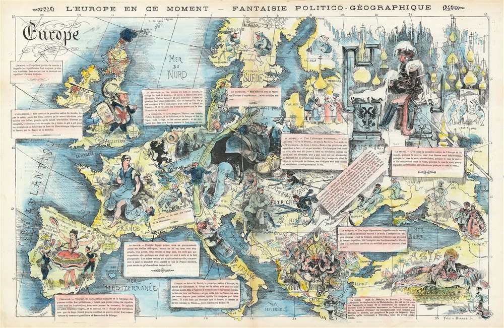
L'Europe en Ce Moment - Fantaise Politico-Géographique.
sold
- Digital Map Information
- Suitable for large format printing
- File Size: 21.65 MB
- File Type: ZIP / TIFF
- ICC color profile embedded
- Delivered instantly via download link
This is an 1872 Yves and Barret caricature map of Europe after the Franco-Prussian War. Coverage embraces all of Europe, from the Atlantic Ocean to the Caspian Sea and from Scandinavia and the Shetland Islands to the Mediterranean Sea. Illustrated personifications of each nation define the author's political viewpoints. Newly united Germany dominates central Europe in the form of the Kaiser, who is sprawled across what the French must have considered to be an ominously large territory. He reclines against a cannon and artillery shells, accompanied by a gigantic sword and an empty beer stein - suggesting at once military power, belligerence, and instability. A much smaller German soldier is illustrated holding the puppet strings of several other European countries, including Italy, Spain, and Austria. France, which had just lost the Franco-Prussian War, is represented as Marianne, the French national symbol, being tended by smaller officials and military men. The men are trying to get her to hold back her anger at having German guns pointed at her from Strasbourg (Alsace and Lorraine were annexed by Germany after the Franco-Prussian War) and to form a new government following the defeat, as well as the chaos of the Paris Commune. England is illustrated as a man in armor decorated with the Union Jack holding a book for a shield. He is surrounded by the Bible and bales of cotton. Spain, Italy, and Austria are depicted as contentedly going about their business, per the German soldier's wishes, but the Austrians are illustrated holding scissors, possibly to try to cut ties with the now overly powerful Germany. Russia is a frozen wasteland with their onion-domed churches and a land where everything happens 'because the czar wants it to be'. The Turks represented as a caricature of eastern decadence: a single man surrounded by elegantly dressed women attending to his every whim. (more details)
Boosting moral as the war in China drags on.
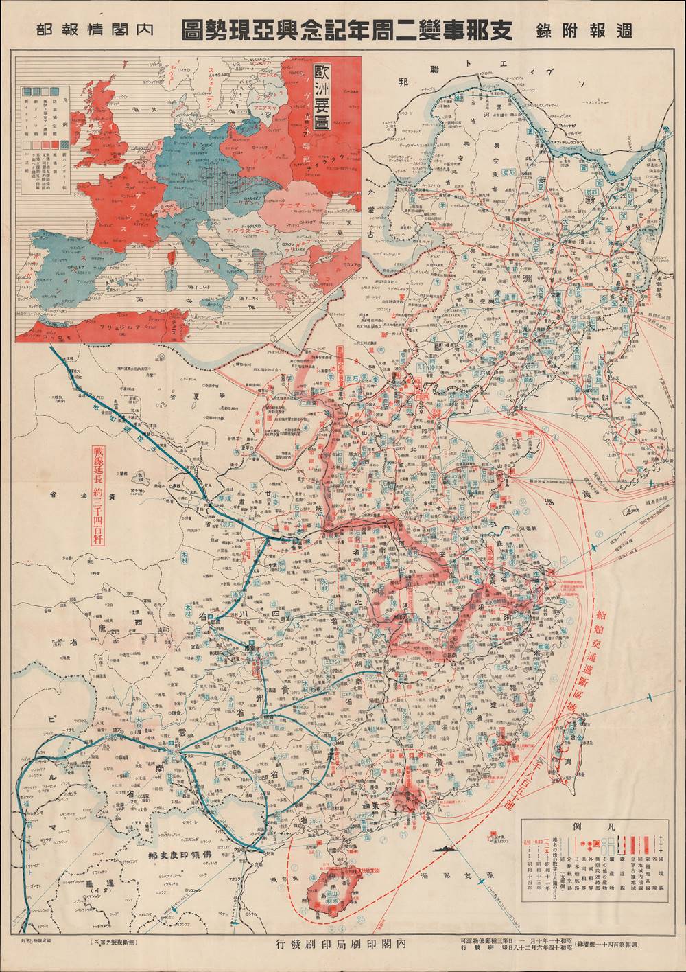
支那事變二周年記念興亞現勢圖 / [Map of the Current Situation, Commemorating the Second Anniversary of the China Incident and the Prosperity of Asia].
sold
- Digital Map Information
- Suitable for large format printing
- File Size: 29.72 MB
- File Type: ZIP / TIFF
- ICC color profile embedded
- Delivered instantly via download link
This is a rare 1939 propaganda map of China and Korea published by the Japanese government's Cabinet Intelligence Bureau (内閣情報部). It illustrates the state of war in China, known to historians as the Second Sino-Japanese War, a distinct theater of World War II. It was published as the war was sliding into a stalemate and was intended to boost morale on the home front. (more details)
Scarce pictorial map of Jackson Hole.

Jackson Hole Picture Map.
sold
This is a 1983 Chris King pictorial map of Jackson Hole, Wyoming. The town of Jackson, Wyoming, occupies most of the foreground, with hotels, restaurants, shops, and more illustrated in profile. 'Signs' label businesses that occupy the same building, such as the Trading Post Mall and Cache Creek Square. Other locations are numerically marked and correspond with verso-content. The Rocky Mountains occupy the background, with Teton Village, Spring Creek Ranch, and Wagon Wheel Village are illustrated. (more details)
A look at Jacksonville's port facilities immediately after WWII.
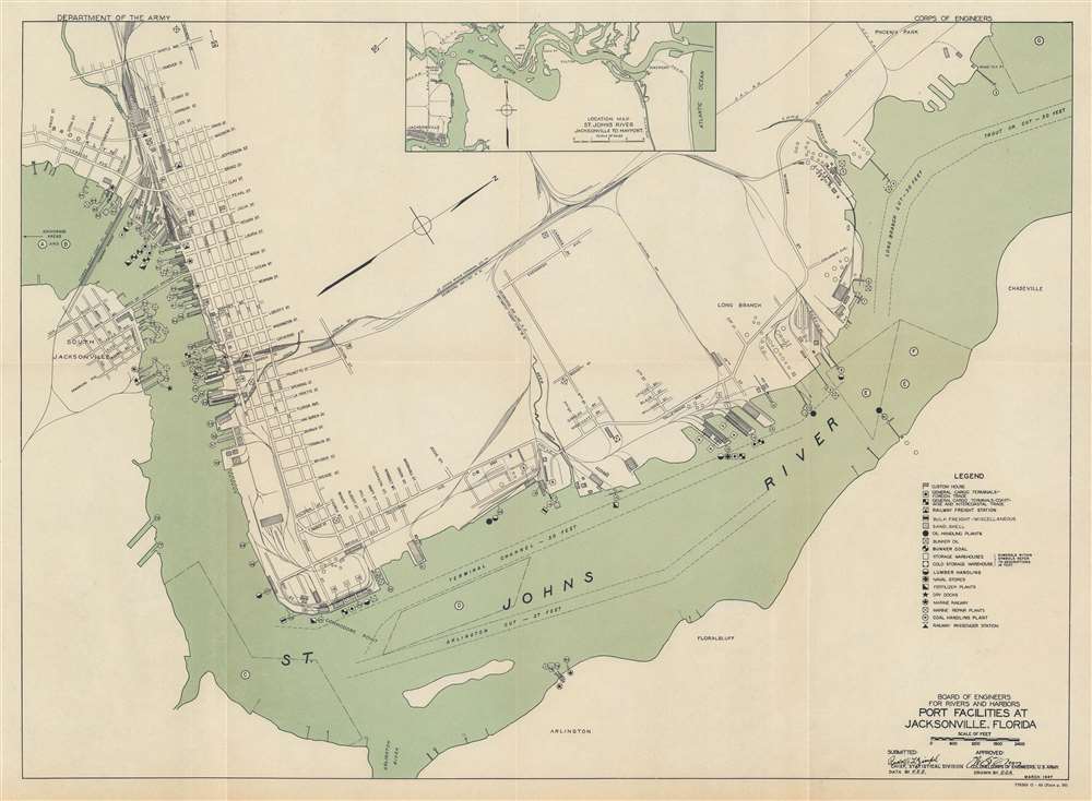
Port Facilities at Jacksonville, Florida.
sold
- Digital Map Information
- Suitable for large format printing
- File Size: 17.41 MB
- File Type: ZIP / TIFF
- ICC color profile embedded
- Delivered instantly via download link
This is a 1948 U.S. Army Board of Engineers for Rivers and Harbors and United States Maritime Commission map of the port of Jacksonville, Florida. Depicting port facilities along the St. John's River, over eighty docks, wharves, and piers are numerically identified and correspond with tables in the text. Other symbols identify warehouses. freight stations, lumber handling, fertilizer plants, dry docks, and other facilities. Streets along the riverfront are illustrated and labeled, along with several railroad lines. Alphabetic circles in the St. Johns River mark anchorages. An inset map of the St. Johns River from Jacksonville to Mayport appears at top center. (more details)
Fascinating document illustrating Bruce's rediscovery of the source of the Blue Nile.

To My Worthy and Learned Friend the Honourable Daines Barrington This Plan of two Attempts to Arrive at the Source of the Nile is dedicated by his most Obliged and faithful Humble Servant James Bruce.
sold
- Digital Map Information
- Suitable for large format printing
- DPI: 300
- File Size: 8.91 MB
- File Type: ZIP / TIFF
- ICC color profile embedded
- Delivered instantly via download link
This is a fascinating, significant, beautifully engraved, intricately detailed 1790 map of Ethiopia (Abyssinia) and the source of the Blue Nile by the Scottish adventurer James Bruce. Centered on Lake Tana (Tzana), this map depicts from the Ethiopian capital at Gondar south as far as the Saccala District and the Geesh Abay (Geesh Springs). (more details)
An early map of the Japanese occupation of Qingdao.

青島 / [Qingdao].
sold
- Digital Map Information
- Suitable for large format printing
- File Size: 6.93 MB
- File Type: ZIP / TIFF
- ICC color profile embedded
- Delivered instantly via download link
This is a unique c. 1916 Japanese map of Qingdao, China, which Japan seized in late 1914 after declaring war on Germany in World War I. It shows Japan's rapid transformation of the city, building off the experience of colonizing Korea and Taiwan in the preceding years. (more details)
Speculation about a land invasion of the Home Islands?

The Invasion of Enemy Planes. / 敵機帝都侵入慨念圖.
sold
- Digital Map Information
- Suitable for large format printing
- File Size: 30.06 MB
- File Type: ZIP / TIFF
- ICC color profile embedded
- Delivered instantly via download link
This is the only surviving example of a top-secret Japanese cyanotype map of Honshu, Japan, detailing American strategic (and not so strategic) bombing raids against the Japanese and speculating on American plans for a forthcoming invasion. Silhouettes of two large airplanes (American B-29s) approach Japan from the south. These planes flew roundtrip from Saipan and Tinian, two islands in the Marianas. Dated February 20, 1945, less than a year after the Americans launched massive invasions to capture both islands and the day after the Americans launch their assault on Iwo Jima, the Japanese are clearly concerned about the U.S.'s progress closer and closer to their homeland. Several large arrows mark presumed invasion routes converging on Tokyo from four different directions. Insets in the upper right and lower left situate Japan geographically with relation to the Philippines and New Guinea and with the islands likely to pose invasion risks. (more details)
Trail guide for pilgrims to Mt. Fuji.

富士山禪定圖 / [Meditation Map of Mt. Fuji].
sold
- Digital Map Information
- Suitable for large format printing
- Full resolution TIFF file
- ICC color profile embedded
- Delivered instantly via download link
This is an extremely rare 1806 folding view of Mt. Fuji, Japan made by the Murayama Sengen Shrine (村山浅間神社) for religious pilgrims seeking to ascend the mountain and worship various kami residing there. (more details)
Europe's Kings, Emperors and Popes at a Glance.
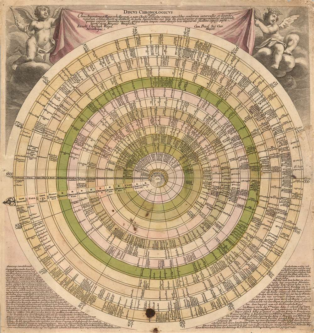
Discus Chronologicus.
sold
- Digital Map Information
- Suitable for large format printing
- Full resolution TIFF file
- ICC color profile embedded
- Delivered instantly via download link
This is Christopher Weigel's 1745 ingenious circular historical chart listing the reigns of the monarchs of Europe, as well as the Papacy, the Byzantine emperors and the Turkish Sultans. The chart lists fourteen categories of rulers chronologically from 1 CE to a potential limit of 1800 CE. A rotating volvelle - with each specific empire noted - allows the reader to rotate to see, at a glance, which monarchs reigned contemporaneously; each ruler's name is accompanied with the date of their coronation. (more details)
A guide to the beauty and splendor of the imperial city.

都名所自在步行 / [Stroll around Famous Sites of Kyoto].
sold
- Digital Map Information
- Suitable for large format printing
- Full resolution TIFF file
- ICC color profile embedded
- Delivered instantly via download link
This is a very rare 1863 edition of a folding map for tourists and pilgrims to Kyoto, Japan, made by the publishing house Takehara Yoshibē. It is the product of a decades-long evolution of tourist maps for Kyoto, resulting in a delicate balance between aesthetics, comprehensiveness, and utility. (more details)
One of the First Detailed Depictions of the Maldives.
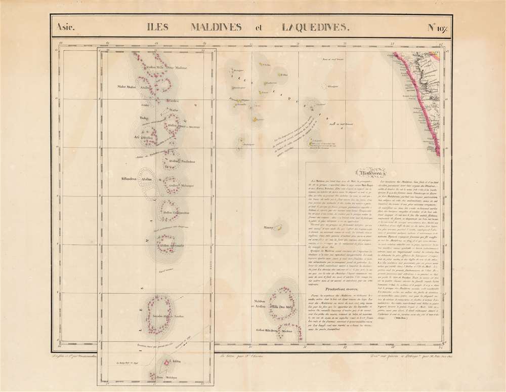
Iles Maldives et Laquedives. Asie. no. 107.
sold
- Digital Map Information
- Suitable for large format printing
- Full resolution TIFF file
- ICC color profile embedded
- Delivered instantly via download link
This is the rare 1827 Vandermaelen map of the Indian Ocean archipelagoes of the Maldives and the Laccadive Islands. It is the first map to specifically focus on these islands. The map of the Maldives - presented as an inset extension of the main map - illustrates the chain of lagoons in sharper detail than any other to date. In particular, the map presents two ships' tracks through the Huvadhu Channel. Since this was and is the broadest channel between any other atoll of Maldives. Its identification by the ships Contractor in 1792 and the Fatty Rair in 1795 would make the channel an important feature to highlight. As a matter of contrast, other channels are identified either as 'dangereux' ('dangerous') or 'inconnu' ('unknown'). The secrets of navigating the Maldives had long been the island kingdom's first line of defense - and the discovery of this channel by European powers was the first break in these defenses in more than 300 years. This was among the largest-scale maps of this region produced to date. Vandermaelen's Atlas, by applying a uniform scale to every map, afforded sharper detail to many remote areas of the world previously not so well depicted. This is also the first map of the region executed in lithograph. (more details)
Military and economic power on the eve of World War II.

最新世界大地圖 / [Latest World Map].
sold
- Digital Map Information
- Suitable for large format printing
- File Size: 76.69 MB
- File Type: ZIP / TIFF
- ICC color profile embedded
- Delivered instantly via download link
This is a 1933 world map published by the Osaka Asahi Shimbun in the early phase of the Second Sino-Japanese War, an antecedent to and later a theater of World War II. The global tensions that would define World War II are evident here, particularly in the inset map at bottom-left showing the relative military strength of major powers. (more details)
The California Gold Region!
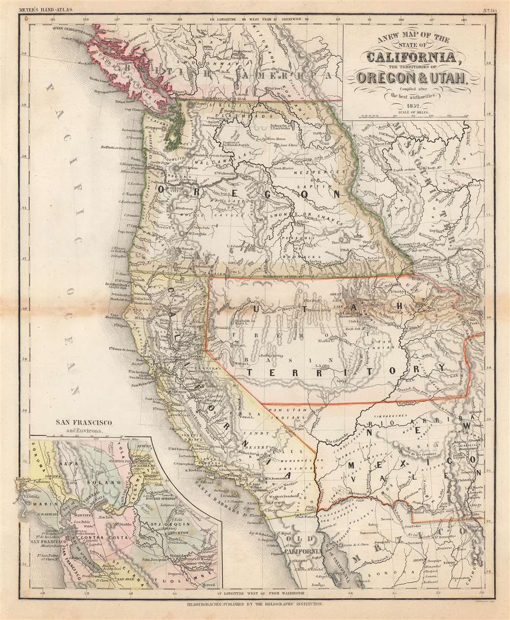
A New Map of the State of California, the Territories of Oregon and Utah.
sold
- Digital Map Information
- Suitable for large format printing
- Full resolution TIFF file
- ICC color profile embedded
- Delivered instantly via download link
This is an 1852 Joseph Meyer map of California and the territories of Utah and Oregon two years after California became a state. California's borders are recognizable being roughly the same as today. The Oregon Territory stretches from the Pacific Ocean to the Rocky Mountains, and the Utah Territory reaches from the modern-day California-Nevada border to Long's Peak, Colorado. The lower portion of Nevada and Utah were then part of the New Mexico Territory. Settlements are labeled throughout, including those of First Peoples nations. (more details)
DetaileddDepiction of the upper Paraguay and Parana rivers.
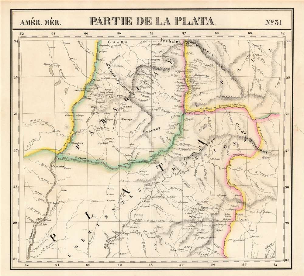
Partie de la Plata. Amer. Mér. no. 31.
sold
- Digital Map Information
- Suitable for large format printing
- Full resolution TIFF file
- ICC color profile embedded
- Delivered instantly via download link
This is the rare 1827 Vandermaelen map of the northern extents of the rivers Paraguay, Parana, and Uruguay in South America. The map is centered on the region of the Misiones, a contentious frontier between the colonial powers in South America. It was produced after the 1814 annexation of the Misiones to Argentina's Corrientes, but in practice, neither Argentina nor any other country exerted de facto control, leaving the area to effectively govern itself. Three years after the printing of this map, the Argentine military took control of the region.
The area takes its name from the 17th century Jesuit establishment of missions among the native Guarani in this area, setting up a number of Jesuit Reductions and establishing as many as thirty mission villages. Along the three major rivers of the region, the map illustrates the settlements in detail. This was among the largest-scale maps of this region produced to date. Vandermaelen's Atlas, by applying a uniform scale to every map, afforded sharper detail to many remote areas of the world previously not so well depicted. This is also the first map of the region executed in lithograph. (more details)
The area takes its name from the 17th century Jesuit establishment of missions among the native Guarani in this area, setting up a number of Jesuit Reductions and establishing as many as thirty mission villages. Along the three major rivers of the region, the map illustrates the settlements in detail. This was among the largest-scale maps of this region produced to date. Vandermaelen's Atlas, by applying a uniform scale to every map, afforded sharper detail to many remote areas of the world previously not so well depicted. This is also the first map of the region executed in lithograph. (more details)
Celebrating the Mounties.
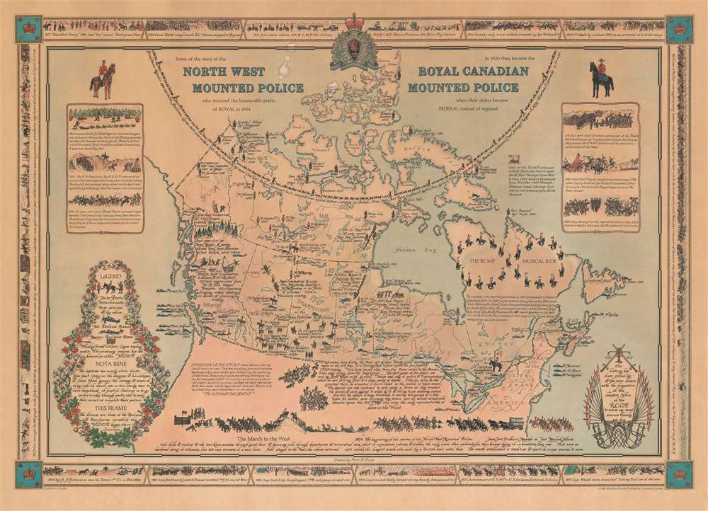
Some of the story of the North West Mounted Police who received the honourable prefix of Royal in 1904. In 1920 they became the Royal Canadian Mounted Police when their duties became Federal instead of regional.
sold
This is an extremely rare 1966 Peter Furse pictorial map of Canada celebrating the history of the Royal Canadian Mounted Police (R.C.M.P.). Forts, posts, and air and marine detachments are identified throughout, and the founding date of each outpost is provided. Numerous historical events are referenced in the captions and many of the officers involved are identified by name. The RCMP Musical Ride is highlighted in Quebec, with the policemen and their mounts creating an infinity symbol, and a short caption provides a concise history of the ride. A longer text presents the early situated in the Northwest United States recounts the formation of the N.W.M.P., while a second text along the U.S.-Canada border tells the story of the Sioux and their flight to western Canada in an attempt to evade the three U.S. armies pursuing them. The column of horses, men, and equipment along the bottom border illustrates 'The March to the West' of 1874 soon after the founding of the Northwest Mounted Police (the forerunner of the R.C.M.P.), which has the distinction of being the longest march made by a British unit up to that time. A pictorial border, consisting of views of historic events in the history of the R.C.M.P. surrounds the central map. (more details)
A map for the Japanese home front, marking the capture of Shanghai.

南京-上海地方詳細圖 / [Detailed Map of the Nanjing-Shanghai Region].
sold
- Digital Map Information
- Suitable for large format printing
- Full resolution TIFF file
- ICC color profile embedded
- Delivered instantly via download link
This is a 1937 map of the Nanjing-Shanghai region in China, published in the Japanese magazine King at the height of the fighting in that area during the Second Sino-Japanese War. It served as a means of familiarizing the Japanese home front with the geography of the battlefield in China. (more details)
Tokugawa Japan looks west.

清朝一統之圖 / [Map of the Unified Qing Dynasty].
sold
- Digital Map Information
- Suitable for large format printing
- Full resolution TIFF file
- ICC color profile embedded
- Delivered instantly via download link
This is an 1835 Japanese xylographic map of the Qing Empire and much of Asia - a curiosity issued in Japan despite the isolationist Tokugawa policies. It is further notable for recognizing and praising the Manchu-led Qing Dynasty, whereas many Japanese maps of the era ignored or even denigrated the Manchus. Yet it retains common elements of Tokugawa-era maps of China, such as historical and religious (Buddhist) references as well as cartographic anachronisms, rooted in Japan's admiration for and fascination with ancient Chinese culture. (more details)
A Superb Example of the Earliest Acquirable Printed Map of the African Continent.

La table et description universelle de toute l' Afrique, voire estendue outre les limites de Ptol.
sold
- Digital Map Information
- Suitable for large format printing
- Full resolution TIFF file
- ICC color profile embedded
- Delivered instantly via download link
This is a 1552 French Cosmographie Universelle edition of Sebastian Münster's 1540 map of Africa, the earliest map of the continent available to the collector. For more than thirty years during the age of discovery, this map would be the predominant representation of Africa for the European reader. The purpose of the map was to reveal, to a lay readership, the still-momentous discoveries that the waters around Africa represented a navigable route to the Indian Ocean, a reality not known to classical geographers. The Latin title of the map emphasizes this:
'The map and description of the whole of Africa extended even beyond the limits of Ptolemy.'Within its generally-recognizable depiction of the shape of the continent, Münster's work presents an amalgam of sources. Most of the general detail of North Africa is derived from Ptolemaic geography, as is the depiction of the Nile with its sources in the lakes of the Mountains of the Moon (Ptolemy's assumptions about the sources of that river would remain unchallenged on maps of Africa until the end of the 17th century.) Many place names in North Africa were likely drawn from Leo Africanus' 1526 Descrittione dell 'Africa, though many - for example, Garamantes - are drawn from classical historians such as Herodotus. Münster draws on Portuguese sources for west Africa. (Cadamosto's 15th century journeys there would reveal the Cape Verde Islands, which appear here.) Numerous kingdoms are noted throughout the continent and are marked by a crown and scepter. Some of these include the Arab kingdoms of Melinde and Quiola, Meroë, where the Nubian kings are said to be buried, and Hamarichthe capital of the kingdom of the mythical Christian king Prester John. In an elegant frame, Münster includes a descriptive text describing the route taken by the Portuguese around the African coast to arrive at Calicut, modern Kozhikode on the western coast of India:
From Lusitania (Portugal) one may come by sea road to Calechut, which is the greatest commercial town in any eastern country. By the western coast of Mauritania and Getulie goes south to Cap Verde. There we find the Isles des Hesperides (also called Fortunate Isles, this is a name given by the ancients to a series of islands located to the extreme west of the then known world.) After we have passed south of Ethiopia, we find the southern cape, which is is the cape of good hope, which reaches nine degrees beyond the tropic. After a tour around the region, we came upon a promontory called Prassus, which is a land raised in the sea: Ptolemy named this region at his southern limits, which were unknown lands. Then one finds the path to go to the troglodytes, where there is a silver mine called Zaphal, which the ancients knew (this island is shown on the map but referred to as 'golden'). From there one passes through the kingdom of Melinde; then we enter the Barbaric Sea and from here we enter the Indian ocean and from there we come to Calecut.(The text is typeset, and changes typographically from edition to edition - but in all editions it appears to adhere to this same topic.) (more details)
WWII in the Pacific: drafted to discharged.

[Untitled Manuscript Pacific War Route Map].
sold
- Digital Map Information
- Suitable for large format printing
- File Size: 2.77 MB
- File Type: ZIP / TIFF
- ICC color profile embedded
- Delivered instantly via download link
A remarkable survival, this is a c. 1947 manuscript pictorial route map of the Pacific War following the World War II service of a U.S. Navy man. Pictorial vignettes highlight the sailor's wartime experience: swearing in, working at the Charleston Navy Yard, surveying the Pacific, weathering typhoons, mine sweeping, good times in Shanghai, and the voyage home. Dated lines trace his travels, with red dates marking wartime movements and yellow dates identifying his return. (more details)
How a wood and paper city burns.

帝都大震火災系統地圖 / Map of the Fire of Tokyo.
sold
- Digital Map Information
- Suitable for large format printing
- File Size: 69.11 MB
- File Type: ZIP / TIFF
- ICC color profile embedded
- Delivered instantly via download link
An astounding infographic masterpiece detailing the ignition and development of the Great Fire of Tokyo following the 1923 Great Kanto Earthquake. This is a partially bilingual 1923 map of Great Tokyo Fire was issued by the Bureau of Tokyo Imperial University just four months after the disaster. It focuses ignition points and on the strong winds that coincided with the earthquake, which caused fire to spread rapidly and eventually burn down much of the city - which was constructed of tightly packed wooden buildings. (more details)