
A charming pictorial map of the coast of Massachusetts - features an illustration of the Gloucester Sea Serpent and several famous ships.
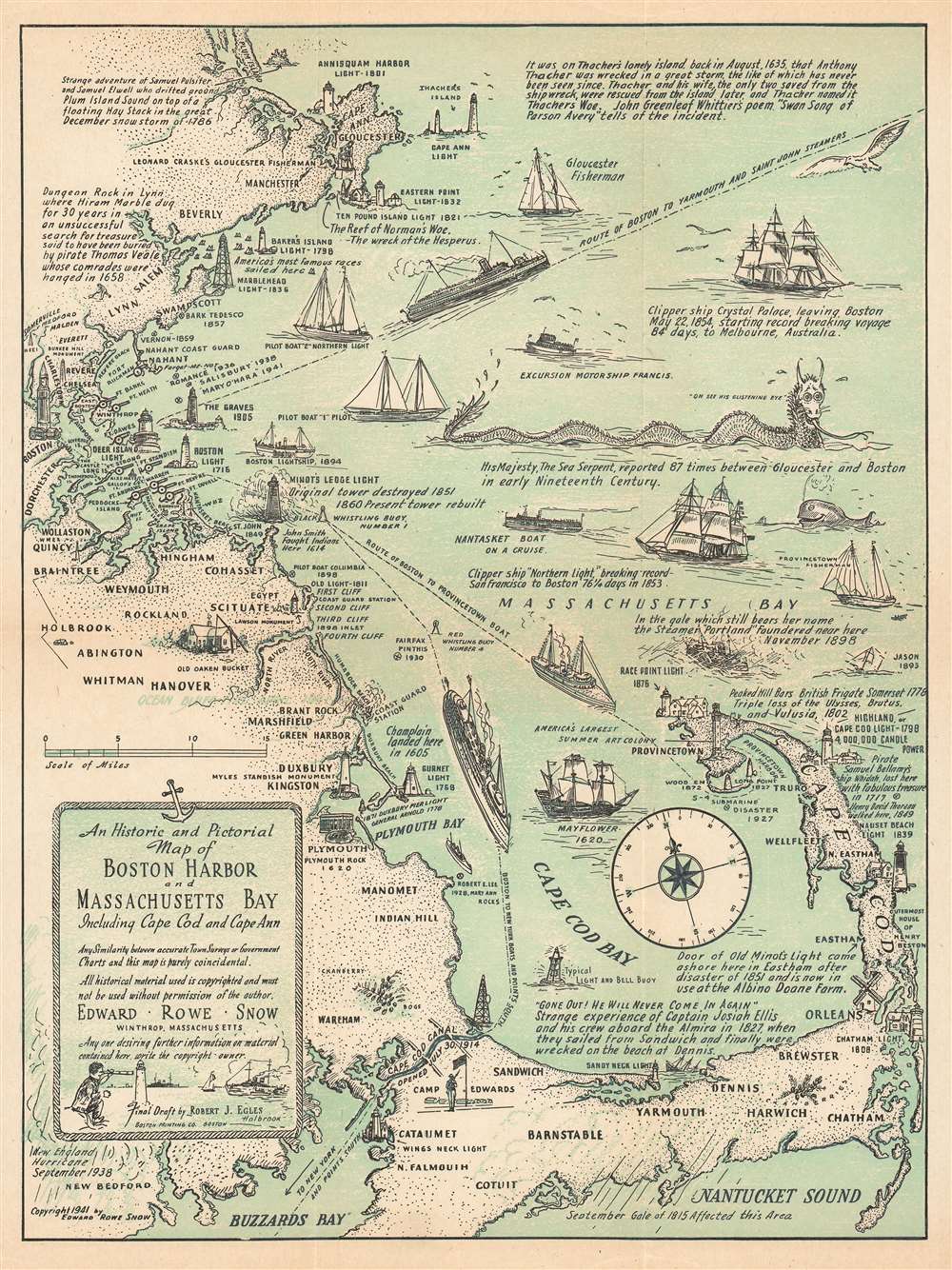
An Historic and Pictorial Map of Boston Harbor and Massachusetts Bay Includeing Cape Cod and Cape Ann.
sold
- Digital Map Information
- Suitable for large format printing
- File Size: 11.9 MB
- File Type: ZIP / TIFF
- ICC color profile embedded
- Delivered instantly via download link
This is a 1941 Edward Rowe Snow pictorial map of Boston Harbor, Massachusetts Bay, and Cape Cod. The Map depicts the Atlantic coast of Massachusetts from Cape Ann to Buzzards Bay and Nantucket Sound. Highly detailed, numerous locations along the Massachusetts coast ... (more details)
A promotional piece for a clothing brand based in Buffalo, New York featuring a 1935 calendar.

Hand-Needled Stylan Valu Clothes Manufactured by Simon Greenbaum 479 Washington Street, Cor. Mohawk - Buffalo, N.Y.
sold
- Digital Map Information
- Suitable for large format printing
- File Size: 19.74 MB
- File Type: ZIP / TIFF
- ICC color profile embedded
- Delivered instantly via download link
Created as a promotional piece for Stylan Valu Clothes, this extremely rare 1934 Whitney Graham city map or plan of Buffalo, New York also features a 1935 calendar. The map, situated above the calendar, depicts the city from Lake Erie and the Niagara River to the City Line and from Grover Cleveland Park to South Park and the South Park Conservatory. Streets throughout the city are identified, as are the railroads, canals, bridges, and parks. The University of Buffalo is illustrated and labeled in the upper right quadrant. The Stylan Valu factory, located at 479 Washington Street, is marked by large black lettering and an arrow pointing out its location. (more details)
Nautical chart of the Mississippi River Delta.
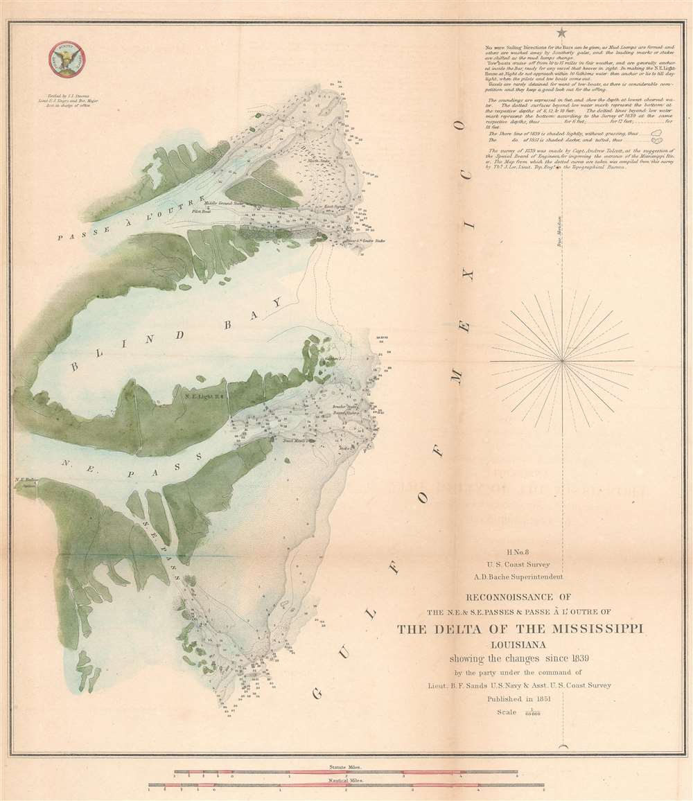
H No. 8 Reconnoissance of the N.E. and S.E. Passes and Passe A l'Outre of The Delta of the Mississippi Louisiana.
sold
- Digital Map Information
- Suitable for large format printing
- DPI: 600
- File Size: 9.65 MB
- File Type: ZIP / TIFF
- ICC color profile embedded
- Delivered instantly via download link
An attractive hand colored 1851 U.S. Coast Survey nautical chart or map of the Mississippi Delta. The map depicts the Louisiana coast from Passe À L'Outre to the Southeast Pass. Numerous depth soundings are included and the locations of lighthouses, shoals, Drift ... (more details)
One of the most beautiful, important, and enduring maps of Manhattan ever published.
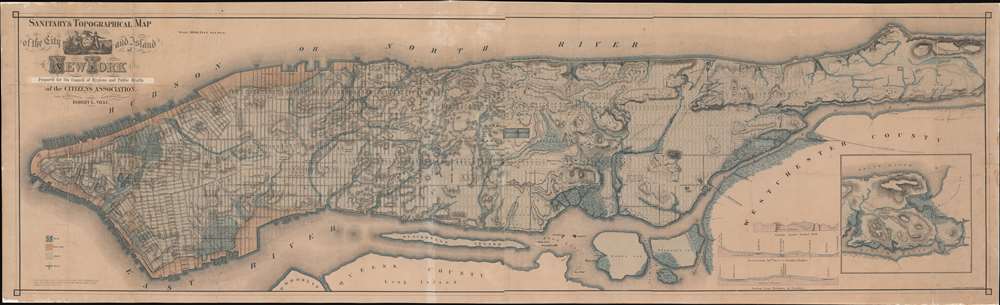
Sanitary and Topographical Map of the City and Island of New York. Prepared for the Council of Hygiene and Public Health of the Citizens Association.
sold
- Digital Map Information
- Suitable for large format printing
- File Size: 82.92 MB
- File Type: ZIP / TIFF
- ICC color profile embedded
- Delivered instantly via download link
This is Egbert L. Viele's 1865 topography and waterways map of Manhattan, one of the scarcest, most important, and most enduring maps of New York City ever published. Covering the entirety of Manhattan Island, Viele's map details the canals, swamps, rivers, ditches, ponds, meadows, and drainage basins of Manhattan as they existed prior to the city's urban development. A version of the Viele map remains in use today by architects and contractors who need to be certain they are not building over underground rivers and swamps that may destabilize a new construction's foundation. (more details)
A plat book of Miami Beach illustrating the many changes in the city over a twenty-year period.
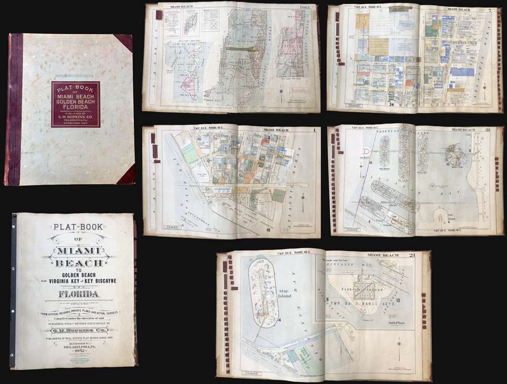
Plat-Book of Miami Beach to Golden Beach also Virginia Key and Key Biscayne Florida.
sold
This is a rare and extraordinary 1952 G. M. Hopkins Company cadastral plat atlas of Miami Beach, Florida. Containing 29 maps, illustrating every part of the city, including the Art Deco District, Ocean Drive, the Lincoln Road Mall, Star Island, Venetian Island, Hibiscus Island, Palm Island, Belle Isle, Indian Creek, etc. The detail throughout is outstanding, naming theaters, office buildings, hotels, public utilities, private properties, golf courses, racetracks, and much much more. This atlas was designed for use by the insurance industry to help assess property risk and value. Moreover, the maps were intended to be updated and revised as properties changed with labeled cutout pastedowns. Most, if not all, of the maps in this atlas exhibit such changes, bringing the plat book current to roughly 1973. (more details)
Important Revolutionary war coastal chart of the Sea Islands in South Carolina, Georgia, and northern Florida.
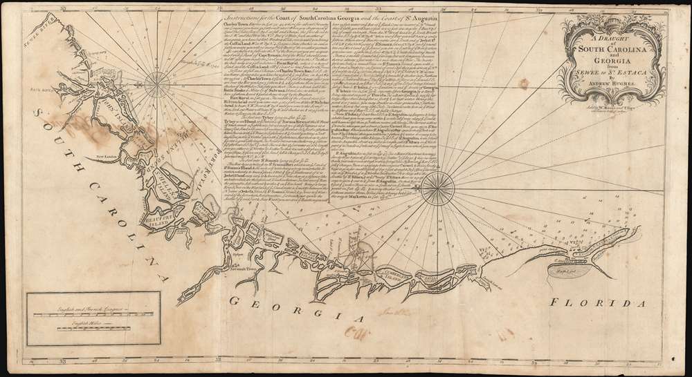
A Draught of South Carolina and Georgia from Sewee to St. Estaca.
sold
- Digital Map Information
- Suitable for large format printing
- DPI: 600
- File Size: 43.98 MB
- File Type: ZIP / TIFF
- ICC color profile embedded
- Delivered instantly via download link
A rare and important 1778 American Revolutionary War era Andrew Hughes nautical chart or maritime map of the coasts of South Carolina, Georgia, and northern Florida. During the early part of the Revolutionary War, this was the best obtainable nautical chart of the Sea Islands. Oriented to the east, this stunning map covers the Atlantic coast from the Santee River (Sewee River), South Carolina, past Charleston, Beaufort, and Savannah, to Saint Augustine, Florida. In addition, the map offers extensive and valuable piloting instructions addressing the entire coast line as well as most individual islands, including Tybee Island, Amelia Island, and Sapelo Island. It also includes excellent coverage of the region's shoals, anchorages, currents, marsh lands, river estuaries, and tides marks. (more details)
A definitive map of the Pacific Northwest, considered by Wheat, 'really quite extraordinary.'
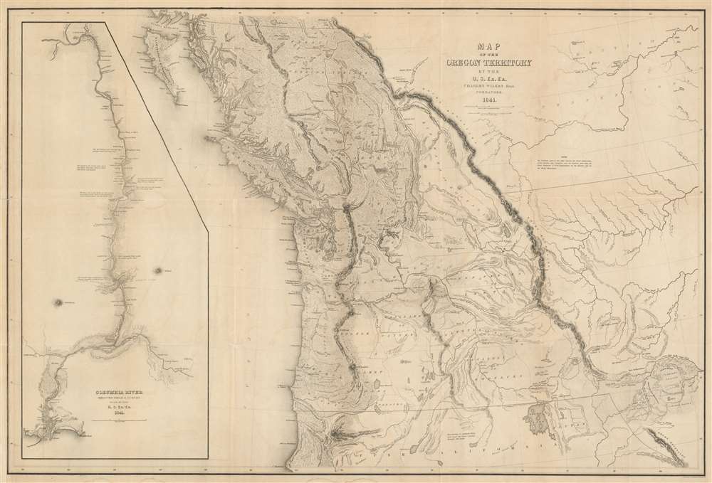
Map of the Oregon Territory by the U.S. Ex. Ex.
sold
- Digital Map Information
- Suitable for large format printing
- DPI: 600
- File Size: 59.51 MB
- File Type: ZIP / TIFF
- ICC color profile embedded
- Delivered instantly via download link
This important and extraordinary production is Commodore Wilkes' 1841 U.S. exploring expedition map of Oregon Territory, the finest and most important map of Oregon of the 19th century. The map covers roughly from the 50th parallel to Mount Shasta, the upper Sacramento River, and Great Salt Lake (Youta Lake) and from the Pacific to the Black Hills. It includes, either in part or full, modern day Washington, Oregon, British Columbia, Vancouver, Idaho, Utah, Nevada, Montana, Wyoming, and California. A large inset occupying the left quadrants focuses on the Columbia River where the United States exploring expedition lost one of its ships, the Peacock, on the infamous Columbia Bar. Topography is rendered by hachure and the engravers even made some attempt to illustrate the vast pine forests of the Pacific Northwest. (more details)
One of the earliest obtainable views of the 1775 American Revolutionary War Battle of Bunker Hill.
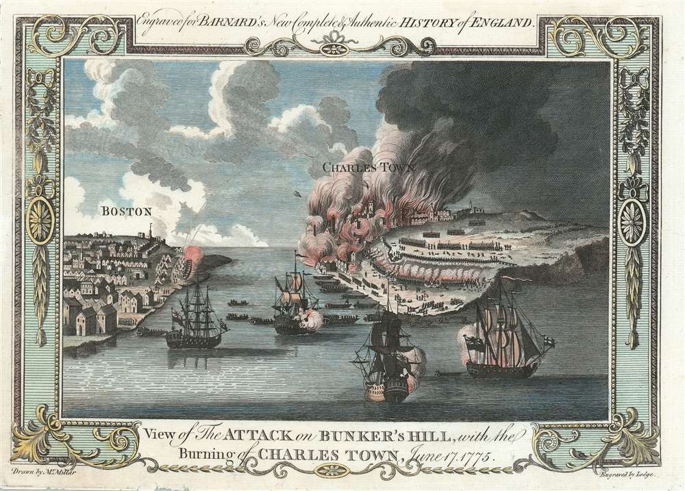
View of the Attack on Bunker's Hill, with the Burning of Charles Town, June 17, 1775.
sold
- Digital Map Information
- Suitable for large format printing
- Full resolution TIFF file
- ICC color profile embedded
- Delivered instantly via download link
One of the earliest obtainable views of the 1775 American Revolutionary War Battle of Bunker Hill. Published in 1783, this view illustrates the June 17, 1775 Battle of Bunker Hill, Boston, one of the first and most significant battles of the American Revolutionary War (1775 - 1783). The view looks east from Boston Harbor. Boston is on the left, Charlestown and Breed's Hill are afire on the right. British naval vessels fill the harbor, while long range cannons bombard Charlestown from Boston. The view is reasonably accurate, suggesting that the artist, 'Mr. Millar', probably George Henry Millar, may have witnessed the battle first hand or drew upon the experience of one who had. (more details)
View illustrating Sugarloaf, Maine's most popular ski resort.

Kingfield, ME. Franklin. Co. 1895.
sold
- Digital Map Information
- Suitable for large format printing
- File Size: 42.56 MB
- File Type: ZIP / TIFF
- ICC color profile embedded
- Delivered instantly via download link
A superb 1895 George E. Norris aquatint bird's-eye view of Kingfield, Maine. The view looks west on Kingfield from a hypothetical highpoint to the east of town, across the Carrabassett River. The primary streets of the town on both sides of the river are noted, as are private residences, service facilities, shops, hotels, and government offices. Behind the town some of Maine's most famous mountains are visible, including Sugarloaf Mountain (now a ski resort), Mt. Abraham, Mt. Redington, and Crocker Mountain. An inset in the lower right looks north from Maple Street to Bigelow Mountain. (more details)
The first and most important map of the colony of Liberia.

Map of the West Coast of Africa, from Sierra Leone to Cape Palmas; including the Colony of Liberia: Compiled chiefly from the surveys and observations of the Late Revd. J. Ashmun.
sold
- Digital Map Information
- Suitable for large format printing
- DPI: 600
- File Size: 7.1 MB
- File Type: ZIP / TIFF
- ICC color profile embedded
- Delivered instantly via download link
The most important early map of Liberia issued shortly after its founding. This map was published in 1830 by Anthony Finley based upon the cartography of Jehudi Ashmun. The map covers the west African coast from Freetown, Sierra Leone, to Cape Palmas. Light red shading indicates territory claimed as Liberia by the American Colonization Society (ACS), while the darker red strip, about 150 miles, indicates regions actually under ACS control. The map is derived by cartography produced by Jehudi Ashmun, an agent of the U.S. Government and the ACS who traveled extensively throughout the region in an attempt to acquire lands and organize peaceful relations with the generally unwelcoming established tribal kingdoms. (more details)
Exceptional piece of Maine history!

Encampment of First Brigade Maine Volunteer Militia Augusta, Aug. 25, 26, 27, 28, 1885.
sold
- Digital Map Information
- Suitable for large format printing
- File Size: 38.24 MB
- File Type: ZIP / TIFF
- ICC color profile embedded
- Delivered instantly via download link
A rare 1885 Poole / Walker view of the encampment of the Maine Volunteer Melita, First Brigade at Augusta, Maine. The view reveals a large parade ground with tents in the foreground. The Kennebec River appears in the background, as does the Augusta 'State Asylum for the Insane.' This view illustrates an annual encampment of the 1st Brigade required by general orders issued in 1884. (more details)
A first edition Mitchell map of Florida - names ephemeral Leigh Read County!
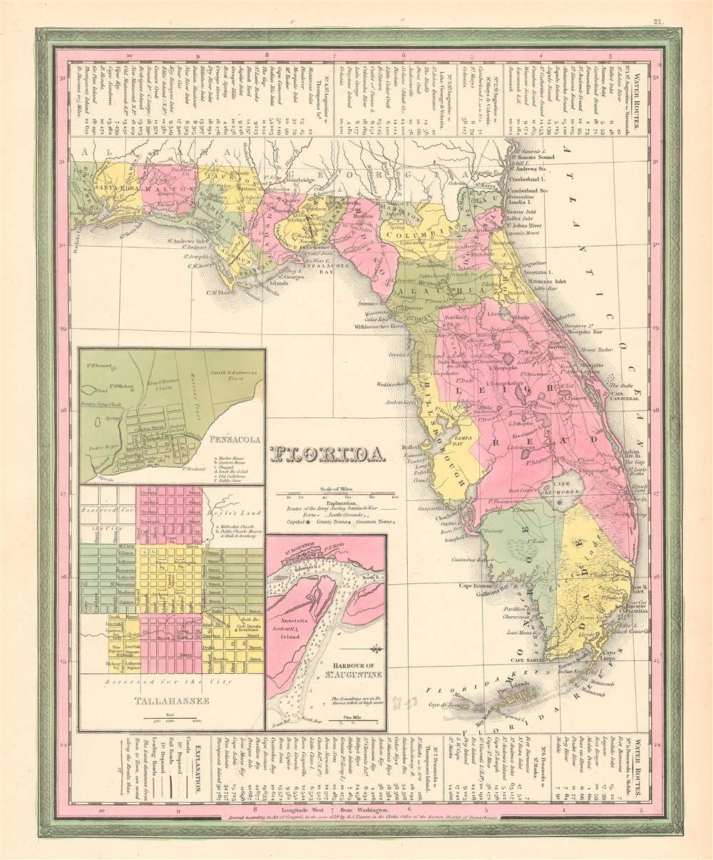
Florida.
sold
- Digital Map Information
- Suitable for large format printing
- DPI: 600
- File Size: 10.59 MB
- File Type: ZIP / TIFF
- ICC color profile embedded
- Delivered instantly via download link
This is a first edition 1846 Samuel Augustus Mitchell and Henry Schenck Tanner map of Florida, notable as being one of the few maps to include the ephemeral Leigh Read County (Mosquito County). The map depicts Florida in full, from the Perdido River to the Atlantic Ocean and from Georgia and Alabama to Key West. Roads connecting the towns, forts, and other settlements are illustrated, along with railroads (there were only 2 at the time) and canals. Inset maps in the lower left corner detail the cities of Pensacola and Tallahassee and the harbor of St. Augustine. Information concerning water routes is included along the top and bottom borders. The whole is surrounded by the Carey and Hart border, which Mitchell only used in this first edition of the atlas. (more details)
A blueback chart of Guadeloupe, a French island department in the West Indies.

Guadeloupe.
sold
- Digital Map Information
- Suitable for large format printing
- File Size: 55.85 MB
- File Type: ZIP / TIFF
- ICC color profile embedded
- Delivered instantly via download link
This is an 1876 James Imray blueback nautical chart or maritime map of the islands of Guadeloupe and Marie Galante in the Caribbean Sea. The map depicts the region from the west coast of Guadeloupe to Désirade Island and from Point Grande Vigie to the Iles des Saintes. Cities, towns, and villages are labeled, including Basse Terre, Trois Rivieres (Trois Rivers as identified here), Goyave, and Pointe-a-Pitre. Coastal landmarks are identified on all the islands in the group, and myriad depth soundings are included along the coastlines as well. Eight inset maps are included along the chart's borders, each of which details a different city or town on Guadeloupe. Inset maps of Port Louis, Port du Moule, Sainte Marie, and Basse Terre as situated along the left border, while Saint Francois, Sainte Anne. Point a Pitre and Petit Havre are included along the right border. (more details)
The only known example of a pictorial map tracing the history and evolution of Toronto, Canada.

An Historical Map of York. Now the City of Toronto.
sold
- Digital Map Information
- Suitable for large format printing
- File Size: 35.35 MB
- File Type: ZIP / TIFF
- ICC color profile embedded
- Delivered instantly via download link
This is a 1932 Mrs. G. Kenneth Douglas and Alice Mackenzie pictorial map of Toronto, Canada, then known as York. The map depicts the city from the Humber River to the Don River and from Eglinton Avenue to Lake Ontario. Douglas and Mackenzie trace Toronto's history from the 18th century to the 1930s using vignettes and captions. The earliest vignette illustrates Fort Rouille, a French trading post built in 1749, but many address the American invasion of Toronto during the War of 1812. Illustrated events include the American landing in 1813, the burning of a man-of-war so that it wouldn't be captured by the Americans, and the burning of the Parliament building. An illustration near the Don River remembers William Roe, who, disguised as an old woman, hid three bags of gold from the treasury, saving it from the invading Americans. Other highlighted events include the fort built of General Simcoe, the first Governor of Upper Canada and the founder of Toronto, the site of the Canadian National Exhibition in 1878, and the ox that was roasted whole to commemorate the coronation of Queen Victoria. Contemporary geography, such as streets and avenues, is used to help the viewer place events throughout the city. Two neighborhoods, Rosedale and High Park, are also labeled. Some of the streets also function as a means of tracing Toronto's growth, for example Bloor Street is labeled as also being the First Concession Line (more details)
Colorful pictorial view of Shakespeare's home city.
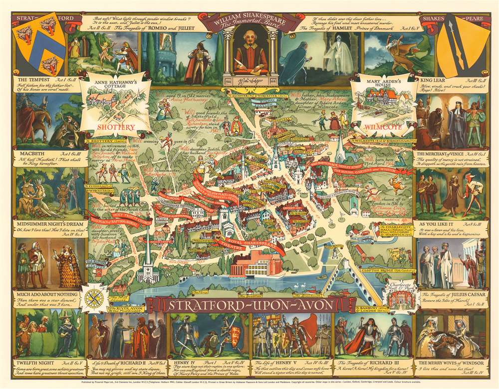
Stratford-upon-Avon.
sold
- Digital Map Information
- Suitable for large format printing
- File Size: 52.33 MB
- File Type: ZIP / TIFF
- ICC color profile embedded
- Delivered instantly via download link
A stunningly vivid and playful 1948 Kerry Lee pictorial map of Stratford-upon-Avon, England. The map looks on the city center from the southeast, across the Avon, with important buildings and Shakespearian locations noted. It is surrounded by 16 images accompanied by quotes drawn from Shakespeare's better-known plays. (more details)
Illustrates the 1864 Battle of Nashville, one of the largest Union victories of the American Civil War.

Battlefields in front of Nashville where the United States Forces commanded by Major General Geo. H. Thomas defeated and routed the Rebel Army under General Hood December 15th and 16th 1864.
sold
- Digital Map Information
- Suitable for large format printing
- File Size: 13.8 MB
- File Type: ZIP / TIFF
- ICC color profile embedded
- Delivered instantly via download link
This is a separately issued 1866 Peseux map of the battles surrounding Nashville, Tennessee which took place on December 15th and 16th 1864. Oriented towards the east, the map depicts the region from the Cumberland River to south of Overton Hills and from Confederate strongpoints east of the city to the Charlotte Pike west of Nashville. Highly detailed, the regions topography is meticulously engraved, with elevations of nearly every high point noted. Most of these were locations for Union strongpoints and forts along the defensive lines constructed south of Nashville. Numerous streets are illustrated heading into / leaving from Nashville, including the Franklin Pike and the Granny White Pike, both of which were used by the defeated Confederate army in their retreat back toward Franklin. The battle is traced in astonishing detail, with each unit represented and colored with a different color scheme to make them easier to identify. Both Rebel and Union works are illustrated, with Rebel works colored red, while Union works are colored blue. Movements from both days of the battle are highlighted, although almost exclusively from the Union perspective. (more details)
A Vietnamese map of the Ho Chi Minh Trail, the critical supply route between North Vietnam and South Vietnam, and also the site of the most intense bombing campaign in human history.
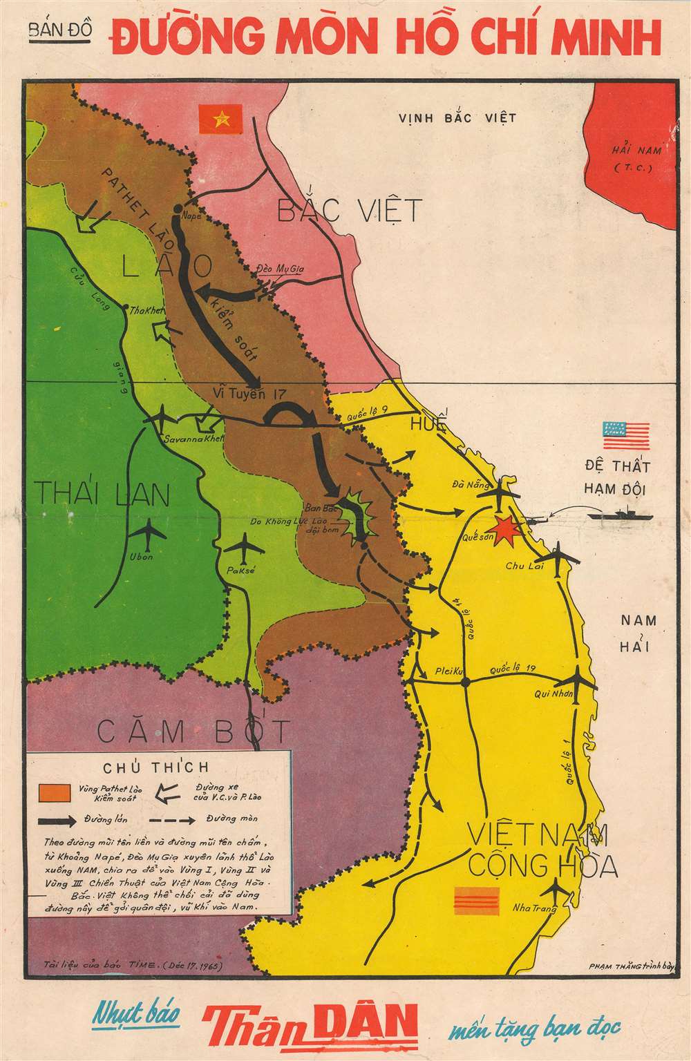
Bản Đồ Đường Mòn Hố Chí Minh. [Ho Chi Minh Trail Map].
sold
- Digital Map Information
- Suitable for large format printing
- File Size: 15.99 MB
- File Type: ZIP / TIFF
- ICC color profile embedded
- Delivered instantly via download link
This is a 1965 Phạm Thăng map of the Ho Chi Minh Trail during the Vietnam War. The map depicts the region from Thailand and Cambodia to the South China Sea and from North Vietnam and Hainan, China to Nha Trang in South Vietnam. Originally published in TIME Magazine, the Ho Chi Minh Trail, illustrated here by thick black arrows, connected North Vietnam and South Vietnam via Laos and Cambodia, allowing the North Vietnamese to ferry troops and supplies into South Vietnam while circumventing the demilitarized zone along the 17th parallel. North Vietnam is colored red here, not surprising since red is a color associated with communism, and South Vietnam is shaded yellow. U.S. air bases at Da Nang, Chu Lai, Qui Nhon, and Nha Trang are marked by airplanes, while an attack at Khe Sanh by the U.S. Seventh Fleet is highlighted by a red explosion.
Outside of Vietnam, Laos is split between light green, territory held by the Royal Lao Government, and brown, the area controlled by the Pathet Lao, a communist political movement that was ultimately victorious in the Laotian Civil War, which raged from 1959 - 1975. The Ho Chi Minh Trail passed through Pathet Lao territory, while the CIA maintained a base at Pakse. Thailand is shaded dark green, while Cambodia is a dark purple. Ubon Royal Thai Air Force Base, one of the bases used by the U.S. Air Force throughout the Vietnam War, is labeled. About 80% of all U.S. Air Force operations against North Vietnam during the Vietnam War originated in Thailand (more details)
Outside of Vietnam, Laos is split between light green, territory held by the Royal Lao Government, and brown, the area controlled by the Pathet Lao, a communist political movement that was ultimately victorious in the Laotian Civil War, which raged from 1959 - 1975. The Ho Chi Minh Trail passed through Pathet Lao territory, while the CIA maintained a base at Pakse. Thailand is shaded dark green, while Cambodia is a dark purple. Ubon Royal Thai Air Force Base, one of the bases used by the U.S. Air Force throughout the Vietnam War, is labeled. About 80% of all U.S. Air Force operations against North Vietnam during the Vietnam War originated in Thailand (more details)
Illustrates the many land cessions from the Cherokee Indians to the American Colonies and then the United States government in the 18th and 19th centuries.
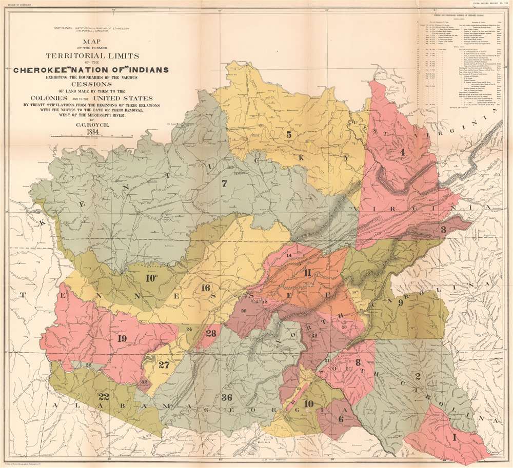
Map of the former Territorial Limits of the Cherokee 'Nation of' Indians Exhibiting the Boundaries of the Various Cessions of Land Made by Them to the Colonies and the United States by Treaty Stipulations. From the Beginning of Their Relations with the Whites to the Date of Their Removal West of the Mississippi River.
sold
- Digital Map Information
- Suitable for large format printing
- File Size: 45.44 MB
- File Type: ZIP / TIFF
- ICC color profile embedded
- Delivered instantly via download link
This is an 1884 Charles C. Royce map of the cessions of the former lands of the Cherokee Indians before they were removed west of the Mississippi. The map depicts the region from west of the Tennessee River to Virginia, North Carolina, and South Carolina, and from the Ohio River to Alabama, Georgia, and South Carolina. Thirty-six different cessions, dating from the colonial period through the 1830s, are traced here, each numerically identified and shaded a different color to allow for easier differentiation. These numbers correspond with an index situated in the upper right corner which provides the viewer with the date and designation of the treaty, a description of the cession, and the color it is shaded. This creates a visual summary of how the Cherokee lost this land during the 18th and 19th century before ultimately being forcibly relocated to lands west of the Mississippi.
These cessions are superimposed on a map that also labels the cities, towns, rivers, and mountain ranges, allowing viewers to have a better understanding of the geography of the cessions in relation to 'modern-day' landmarks. Nashville, Frankfort, Louisville, Lexington, Atlanta and Cincinnati are all identified. The 'Old Road from Nashville to Falls of Ohio' and the 'Old Road from Nashville to Lexington' are both illustrated, along with several others, including 'General Jackson's Old Military Road' and the 'Route of General Robertson's Expedition Against the Indians'. (more details)
These cessions are superimposed on a map that also labels the cities, towns, rivers, and mountain ranges, allowing viewers to have a better understanding of the geography of the cessions in relation to 'modern-day' landmarks. Nashville, Frankfort, Louisville, Lexington, Atlanta and Cincinnati are all identified. The 'Old Road from Nashville to Falls of Ohio' and the 'Old Road from Nashville to Lexington' are both illustrated, along with several others, including 'General Jackson's Old Military Road' and the 'Route of General Robertson's Expedition Against the Indians'. (more details)
A map of the Illinois Central Railroad, one of the oldest Class I railroads in the United States.
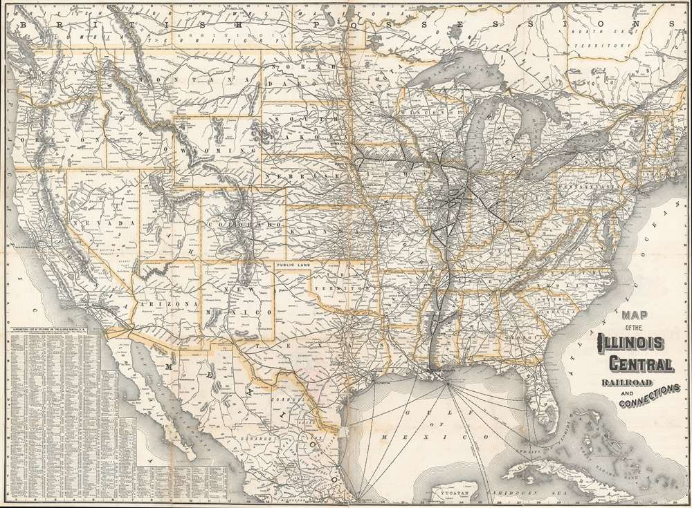
Map of the Illinois Central Railroad and Connections.
sold
- Digital Map Information
- Suitable for large format printing
- File Size: 55.75 MB
- File Type: ZIP / TIFF
- ICC color profile embedded
- Delivered instantly via download link
This is a c. 1891 Rand McNally and Company map of the United States illustrating the Illinois Central Railroad and the rail network throughout the United States. The map depicts the continental United States from the Pacific Ocean to the Atlantic Ocean and from Canada to the Yucatan Peninsula and Cuba. The routes of the Illinois Central are highlighted by bold black lines bisected by white dots, which identify every stop along its lines from Sioux Falls, South Dakota to Cincinnati, Ohio and from Madison, Wisconsin, to New Orleans, Louisiana. Major cities are marked by larger dots, with the largest at Sioux City, Iowa; Chicago, Illinois; St. Louis, Missouri; Cincinnati, Ohio; and Memphis, Tennessee.
The rest of the rail network crossing the United States from coast to coast and winding its way almost everywhere in between branches out from the bolded Illinois Central, as if the entire organization started from its routes. Nearly all the lines are labeled. Major cities and towns throughout the country are identified and state capitals are marked by a special symbol, such as Springfield, Illinois, for example. The country's mountain ranges are illustrated and labeled, as are its major lakes. An alphabetical list of stations on the Illinois Central Railroad is situated in the lower left corner and provides the name of the station and its location on the map's grid. (more details)
The rest of the rail network crossing the United States from coast to coast and winding its way almost everywhere in between branches out from the bolded Illinois Central, as if the entire organization started from its routes. Nearly all the lines are labeled. Major cities and towns throughout the country are identified and state capitals are marked by a special symbol, such as Springfield, Illinois, for example. The country's mountain ranges are illustrated and labeled, as are its major lakes. An alphabetical list of stations on the Illinois Central Railroad is situated in the lower left corner and provides the name of the station and its location on the map's grid. (more details)
A special edition of Soltesz's folklore and legends pictorial map most likely meant for use in classrooms.

Folklore and Legends of Our Country.
sold
- Digital Map Information
- Suitable for large format printing
- File Size: 111.89 MB
- File Type: ZIP / TIFF
- ICC color profile embedded
- Delivered instantly via download link
This is a special edition 1960 Frank J. Soltesz and Esso pictorial map of the United States illustrated with national folklore and legends - with accompanying binder and letter from publisher. Recognizable figures include Paul Bunyan and his Blue Ox, Long Jon Silver, Moby Dick, Jonny Appleseed, the heroes of the Alamo (including Davy Crockett), the Headless Horseman, and John Henry, among others. Insets in the lower left focus on the folklore and legends of Hawaii and Alaska - respectively. Verso includes text explaining map as well as a pictorial road map of the United States. Accompanied by original binder, an smaller map that acts as a key to the main map, and a letter from the publisher. (more details)