
A rare and important Post-Revolutionary War Era map of New England. One of the first maps to recognize Vermont as a state.
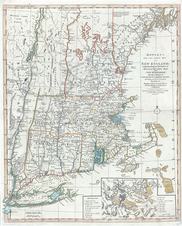
Bowles's New One-Sheet Map of New England; comprehending the Provinces of Massachusets Bay And New Hampshire; with the Colonies of Connecticut & Rhode Island; Divided into their Counties, Townships &c. Together with an Accurate Plan of the Town, Harbour and Environs of Boston.
sold
- Digital Map Information
- Suitable for large format printing
- DPI: 300
- File Size: 20.29 MB
- File Type: ZIP / TIFF
- ICC color profile embedded
- Delivered instantly via download link
A rare separately published c. 1796 map of New England by Bowles and Carver. Centered on Massachusetts, this map covers the New England coastline from Long Island, New York, to Little Kennebec Bay, Maine, and from Cape Cod and Nantucket westward to just beyond the ... (more details)
Scarce Rutter deatiling the Windward Passage.
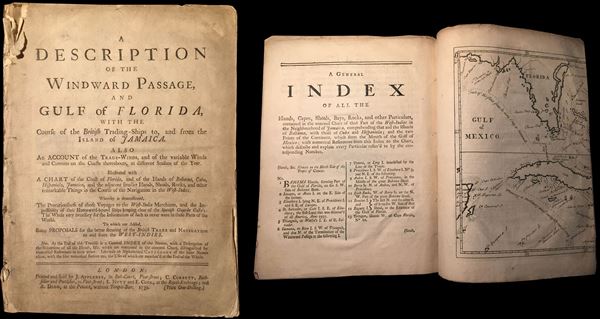
A Description of the Windward Passage and Gulf of Florida, with the course of the British Trading-Ships to, and from the Island of Jamaica. Also an Account of the Trade-Winds and Currents on the Coasts thereabouts, at different Seasons of the Year. Illsutrated with a Chart of the Coast of Florida, and of the Islands of Bahama, Cuba, Hispaniola, Jamaica, and the adjacent smaller Islands, Shoals, Rocks, and other remarkable Things in the Course of the Navigation in the West Indies.
sold
- Digital Map Information
- Suitable for large format printing
- File Size: 1.78 MB
- File Type: ZIP / TIFF
- ICC color profile embedded
- Delivered instantly via download link
An extremely rare first edition of John Cowley's rutter (nautical guidebook) of the West Indies, particularly the important Windward Passage between Cuba and Hispaniola. This document was intended for navigators and tradesmen with an interested in the English ... (more details)
Scarce large map showing the United States on the eve of the Gadsden Purchase.
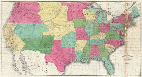
The United States from the Latest Authorities for Hayward's Gazetteer.
sold
- Digital Map Information
- Suitable for large format printing
- DPI: 300
- File Size: 30.01 MB
- File Type: ZIP / TIFF
- ICC color profile embedded
- Delivered instantly via download link
A scarce and attractive large format map of the United States issued in 1853 for John Hayward's Gazetteer of the United States of America . The map covers the United States in full from the 49th parallel to the southern tip of Florida. Cartographically ... (more details)
A seminal production - the first accurate map of the Caspian Sea.

Carte Marine de la Mer Caspiene.
sold
- Digital Map Information
- Suitable for large format printing
- DPI: 300
- File Size: 26.61 MB
- File Type: ZIP / TIFF
- ICC color profile embedded
- Delivered instantly via download link
A seminal production, this is Guillaume Delisle's 1721 map of the Caspian Sea according to the surveys of Van Verden and S. I Soimonov. It is the first printed map of the Caspian Sea based upon actual survey work. Although other cartographers also ... (more details)
A allegorical illustration of the stages of a woman's life.

The Life and Age of Woman. Stages of a Woman's life from infancy to the brink of the Grave.
sold
- Digital Map Information
- Suitable for large format printing
- DPI: 300
- File Size: 18.48 MB
- File Type: ZIP / TIFF
- ICC color profile embedded
- Delivered instantly via download link
An uncommon c. 1835 moralistic broadside attributed to Albert Alden featuring an allegorical illustration of the stages of a woman's life from 1 to 80. Standing astride a brick pyramid, this broadside engraving illustrates a woman's life in 7 ... (more details)
Exceptional map of Asia showing both East Sea and Sea of Korea. - See more at: https://www.geographicus.com/mm5/merchant.mvc?Store_Code=AntiqueMaps&Screen=PROD&Product_Code=EastAsia-chatelain-1719#sthash.feNM6iya.dpuf
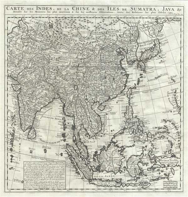
Carte des Indes, dea la Chine and des Iles de Sumatra, Java etc. Dressee sur les Memoires les pulus nouveaux and sur les meilleures Observations, tirees des Relations les plus fideles.
sold
- Digital Map Information
- Suitable for large format printing
- Full resolution TIFF file
- ICC color profile embedded
- Delivered instantly via download link
An exceptional 1719 map of the East India Islands by Henri Chatelain. Centered on China, Chatelain's map covers from the Caspian Sea to the semi-mythical Terre de la Compagnie and India to New Guinea. It provides extraordinary detail ... (more details)
Detailed study of the final battle of the Revolutionary War - the Battle of Yorktown.
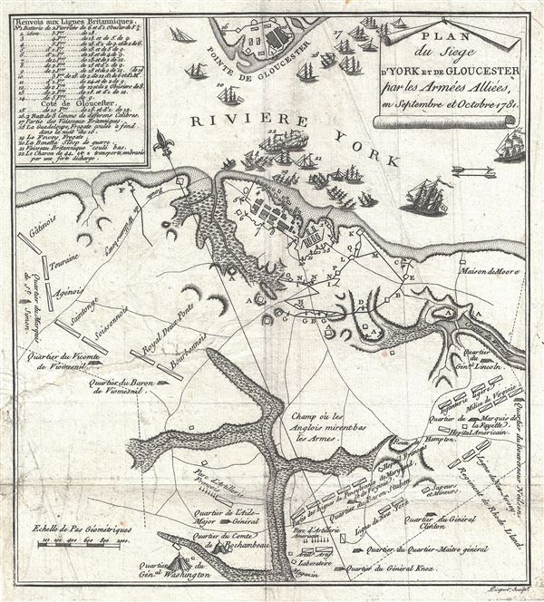
Plan du Siege d'York et de Gloucester par les Armees Alliees en Septembre et Octobre 1781.
sold
- Digital Map Information
- Suitable for large format printing
- DPI: 300
- File Size: 2.55 MB
- File Type: ZIP / TIFF
- ICC color profile embedded
- Delivered instantly via download link
An exceptional 1787 map of the Battle of Yorktown by David Ramsay and Charles Picquet. Ramsay prepared this map for issue in his Histoire de la Revolution d'Amerique , a period account the Siege of Yorktown in which Ramsay ... (more details)
Important map reafirming Qing Unity and dominance following Jahangir's Holy War on the Turkestan Frontier.
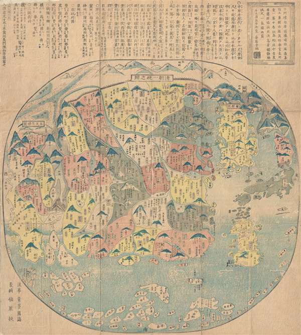
清朝一統之圖 / The unification of the Qing Dynasty. / Shinchō ittō no zu. / Chōi ichiran.
sold
- Digital Map Information
- Suitable for large format printing
- DPI: 300
- File Size: 16.52 MB
- File Type: ZIP / TIFF
- ICC color profile embedded
- Delivered instantly via download link
Ostensibly a天保 Tenpō 6 map of China under the Qing Dynasty, this map in fact covers from India to Japan, inclusive of all of China and Korea, reflecting a pan-Buddhist perspective. The Great Wall is evident at the top ... (more details)
Scarce map illustrating the proposed states of Franklinia and Morgania.
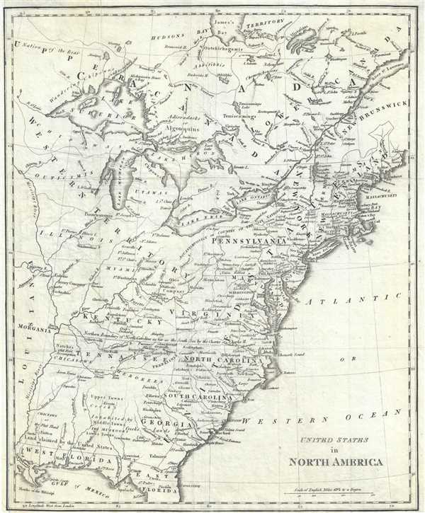
United States in North America.
sold
- Digital Map Information
- Suitable for large format printing
- Full resolution TIFF file
- ICC color profile embedded
- Delivered instantly via download link
This is a fascinating 1812 Sir Richard Phillips map of the United States shortly after the American Revolutionary War as the new country was struggling to resolves issues of state vs federal sovereignty. It illustrates a time of endless possibility, where the ambitious could stake out their own settlements and build trade empires on loosly policed frontiers. This map, while not visually dramatic, includes two such colonies, Franklinia and Morgania. (more details)
Rare French map detailing the Golden Age of Caribbean Piracy.
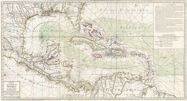
Carte du Golphe du Mexique et des Isles Antilles.
sold
- Digital Map Information
- Suitable for large format printing
- DPI: 300
- File Size: 17.7 MB
- File Type: ZIP / TIFF
- ICC color profile embedded
- Delivered instantly via download link
A fine example of the 1780 Dezauche edition of Buache's important map of the West Indies. Centered on Cuba, this massive map covers Central America, the Gulf of Mexico, the West Indies, and the Caribbean from Mexico and Texas to the Lesser Antilles and from Florida to the Spanish Main. Cartographically, Buache derived this map from Henry Popple's remarkable 1733 map of North America. As a whole it exhibits numerous significant advances over the earlier Buache / De L'Isle model of the region. These include a more sophisticated mapping of peninsular Florida, the Gulf Coast, and the interior of Texas, Florida, and Mexico. The Mission de Los Teijas, one of the first usages of the word 'Texas' on a published map, is noted. Rumb lines are evident throughout, suggesting this map was also based on sea chart sources. (more details)
A grisly French serio-comic map condemning the 'German-instigated' bloodletting of World War I.
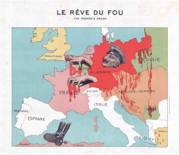
Le Rève du Fou. / The Madman's Dream.
sold
- Digital Map Information
- Suitable for large format printing
- File Size: 1.82 MB
- File Type: ZIP / TIFF
- ICC color profile embedded
- Delivered instantly via download link
This is a 1914 A. Delaye serio-comic map of Europe shortly after the outbreak of World War I. Depicting continental Europe with a blood-red Germany at its center, a portrait of Kaiser Wilhelm II stares greedily at western ... (more details)
A remarkable Pre-Cook polar projection showing the Arctic and the Sea of the West.

Planisphere Physique.
sold
- Digital Map Information
- Suitable for large format printing
- DPI: 300
- File Size: 7.47 MB
- File Type: ZIP / TIFF
- ICC color profile embedded
- Delivered instantly via download link
An exceptionally bright and beautiful c. 1781 Philippe Buache map of the world presented on an unusual polar projection rendered from the North Pole. The map depicts the world from the North Pole Arctic region south ... (more details)
Scarce and beautiful map of New York City.
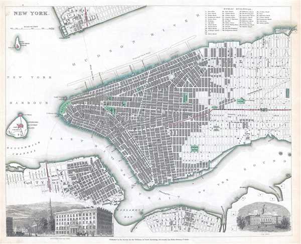
New York.
sold
- Digital Map Information
- Suitable for large format printing
- DPI: 300
- File Size: 6.02 MB
- File Type: ZIP / TIFF
- ICC color profile embedded
- Delivered instantly via download link
This is an 1840 Society for the Diffusion of Useful Knowledge (S.D.U.K.) city map or plan of New York City. The map depicts southern Manhattan from the Battery northwards to 42nd Street as well as portions of ... (more details)
A pictorial map of Jerusalem divided by the pre-1967 border that highlights sites throughout the city.

Jerusalem Old and New.
sold
- Digital Map Information
- Suitable for large format printing
- File Size: 17.33 MB
- File Type: ZIP / TIFF
- ICC color profile embedded
- Delivered instantly via download link
This is a 1955 Steimatzky pictorial map of Jerusalem. The map depicts the city from the Beth Hakerem neighborhood to the Mount of Olives and the Hill of Evil Counsel and from Mt. Scopus to the Meqor Hayim and Beth Mazmil neighborhoods. Perhaps the most significant aspect of this piece is that it dates from 1955, meaning that the 1949 Armistice Agreement between Israel and Jordan was still in effect (the borders would remain the same until after the 1967 Six-Day War), illustrated here by a rather thick red line. (more details)
A beautiful and some would say underappreciated map of central Mexico.

Nova Hispania et Nova Galicia.
sold
- Digital Map Information
- Suitable for large format printing
- DPI: 300
- File Size: 8.78 MB
- File Type: ZIP / TIFF
- ICC color profile embedded
- Delivered instantly via download link
This is a scarce and often underappreciated c. 1690 Petrus Schenk and Gerard Valk map of Mexico or New Spain. Depicting the viceroyalty granted to Hernan Cortez following his conquest of the Aztec Empire, ... (more details)
Beautiful city plan of St. Petersburg, Russia.

St. Petersburg [CAHKTIIETEPBYPTA].
sold
- Digital Map Information
- Suitable for large format printing
- Full resolution TIFF file
- ICC color profile embedded
- Delivered instantly via download link
This is a scarce 1834 map or city plan of St. Petersburg, Russia, published by the Society for the Diffusion of Useful Knowledge. It covers the second largest city in Russia located on the Zayachii Ostrov ... (more details)
Features depictions of Nebraska at its fullest and the unincorporated Dacotah Territory.
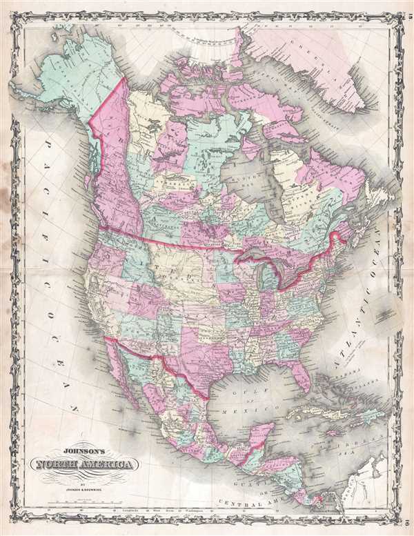
Johnson's North America.
sold
- Digital Map Information
- Suitable for large format printing
- File Size: 12.91 MB
- File Type: ZIP / TIFF
- ICC color profile embedded
- Delivered instantly via download link
This is a beautiful example of A. J. Johnson and Ross C. Browning's 1860 first edition map of North America. The map depicts the continent from the Pacific Ocean to the Atlantic Ocean and from the Arctic Ocean and Greenland to the Bay of Panama and South America. Created just before the outbreak of the American Civil War, Johnson's map captures a unique moment in American history, both geographically and politically. Of particular interest is the geography of the western part of the United States, where the boundaries of several territories were still undecided. By 1865, the American West would look much different than it does here in 1860. (more details)
One of the earliest American charts of the region.

St. Helena Sound South Carolina.
sold
- Digital Map Information
- Suitable for large format printing
- File Size: 11.89 MB
- File Type: ZIP / TIFF
- ICC color profile embedded
- Delivered instantly via download link
This is an 1857 U.S. Coast Survey nautical chart or maritime map of St. Helena Sound, South Carolina. The map depicts the region from the Edisto Islands south past Morgan Island and St. Helena Island to ... (more details)
An amazing map of Florida outlining land occupied by the Seminole Indians a year before the Second Seminole War.

North America XIV Florida.
sold
- Digital Map Information
- Suitable for large format printing
- Full resolution TIFF file
- ICC color profile embedded
- Delivered instantly via download link
This is an uncommon 1834 Society for the Diffusion of Useful Knowledge or S.D.U.K. map of Florida. The map depicts the state of Florida in its entirety with its westernmost portion depicted in an inset ... (more details)
Lovely map depicting Louisiana, Arkansas, Mississippi and vicinity and labels land then owned by the Choctaw Indian Tribe.
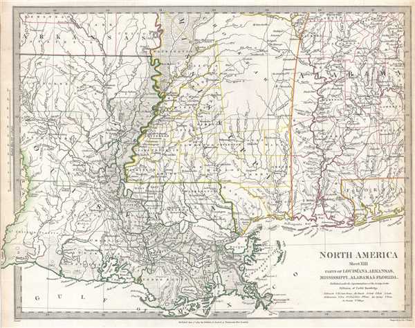
North America Sheet XIII Parts of Louisiana, Arkansas, Mississippi, Alabama and Florida.
sold
- Digital Map Information
- Suitable for large format printing
- Full resolution TIFF file
- ICC color profile embedded
- Delivered instantly via download link
This is an uncommon 1833 Society for the Diffusion of Useful Knowledge or S.D.U.K. map of Mississippi, Louisiana, and Alabama, including a major portion of the states of Louisiana, Mississippi and ... (more details)