
Labels the District of Columbia.

Maryland.
sold
- Digital Map Information
- Suitable for large format printing
- DPI: 300
- File Size: 2.24 MB
- File Type: ZIP / TIFF
- ICC color profile embedded
- Delivered instantly via download link
This is an 1828 Anthony Finley map of Maryland. This rare map plate configuration depicts the state individually rather than bundled with Delaware or Virginia - as is more common. The map illustrates the region from Virginia to New Jersey and from Pennsylvania to ... (more details)
Includes three inset maps - Curacao, the main castle on Curacao, and the course of the Essequibo River.
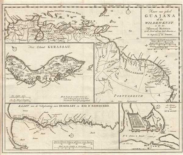
Kaart van geheel Guajana of de Wilden-Kust, en die der Spaansche Westindien op het Noord-end van Zuid-Amerika.
sold
- Digital Map Information
- Suitable for large format printing
- DPI: 300
- File Size: 5.55 MB
- File Type: ZIP / TIFF
- ICC color profile embedded
- Delivered instantly via download link
This is a c. 1767 Isaak Tirion map of northern South America. The map depicts the region from the Caribbean islands of Aruba, Curaçao, and Grenada to the mouth of the Amazon River and from Cartagena (Karthagena), Colombia to the mouth of the Amazon, including the ... (more details)
Labels Frankfort and Lexington.

Kentucky.
sold
- Digital Map Information
- Suitable for large format printing
- DPI: 300
- File Size: 2.17 MB
- File Type: ZIP / TIFF
- ICC color profile embedded
- Delivered instantly via download link
This is an 1828 Anthony Finley map of Kentucky. The map depicts the state and the region from Illinois, Indiana, and Ohio to Tennessee and from Illinois to Virginia in Finley's classic minimalist style. Rivers, roads, canals, and some topographical features are ... (more details)
Labels Cleveland, Columbus, Cincinnati, and Marietta.

Ohio.
sold
- Digital Map Information
- Suitable for large format printing
- DPI: 300
- File Size: 2.51 MB
- File Type: ZIP / TIFF
- ICC color profile embedded
- Delivered instantly via download link
This is an 1828 Anthony Finley map of Ohio. The map depicts the state and the region from Upper Canada and the Michigan Territory to Kentucky and Virginia and from Indiana to Pennsylvania and Virginia in Finley's classic minimalist style. Rivers, roads, canals, ... (more details)
Labels Princeton, Trenton, and many other cities and towns throughout the state.
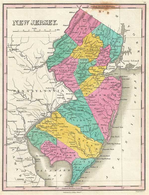
New Jersey.
sold
- Digital Map Information
- Suitable for large format printing
- DPI: 300
- File Size: 2.43 MB
- File Type: ZIP / TIFF
- ICC color profile embedded
- Delivered instantly via download link
This is an 1828 Anthony Finley map of New Jersey. The map depicts the region from Pennsylvania and Delaware to the Atlantic Ocean and from New York and Pennsylvania to Delaware Bay in Finley's classic minimalist style. Rivers, roads, canals, and some ... (more details)
Uncommon 19th century map exclusively depicting Rhode Island - usually it was depicted with Massachusetts or Connecticut.

Rhode Island.
sold
- Digital Map Information
- Suitable for large format printing
- DPI: 300
- File Size: 2.47 MB
- File Type: ZIP / TIFF
- ICC color profile embedded
- Delivered instantly via download link
This is an 1828 Anthony Finley map of Rhode Island. The map depicts the state from Massachusetts to the Atlantic Ocean and from Connecticut to Massachusetts in Finley's classic minimalist style. Block Island is illustrated off the coast near the ... (more details)
Uncommon 19th century map exclusively depicting Vermont - usually it was depicted with New Hampshire.
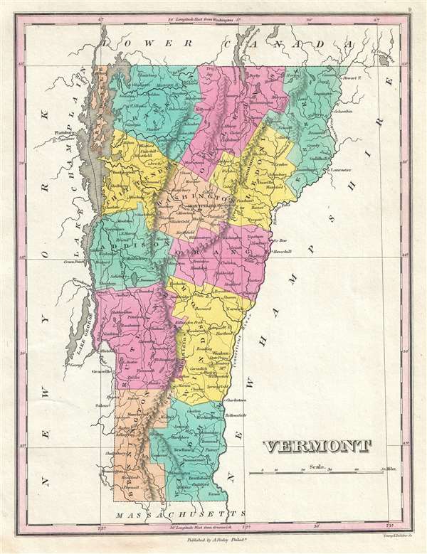
Vermont.
sold
- Digital Map Information
- Suitable for large format printing
- Full resolution TIFF file
- ICC color profile embedded
- Delivered instantly via download link
This is an 1828 Anthony Finley map of Vermont. The map depicts the state from Canada to Massachusetts and from New York to New Hampshire in Finley's classic minimalist style. River ways, roads, canals, and some topographical features are ... (more details)
Beautiful and incredibly detailed map of Brazil.
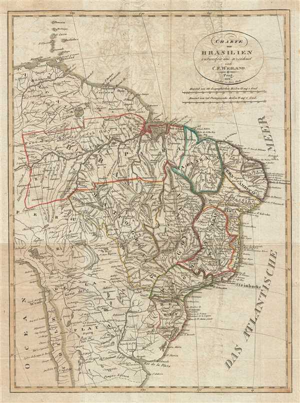
Charte von Brasilien entworfen und gezeichnet nach C. F. Weiland.
sold
- Digital Map Information
- Suitable for large format printing
- DPI: 300
- File Size: 6.24 MB
- File Type: ZIP / TIFF
- ICC color profile embedded
- Delivered instantly via download link
This is an 1822 Franz Pluth map of Brazil. The map depicts the region from the Caribbean islands of Martinique and St. Lucia to the Rio de la Plata and the Pampas and from Peru and the Pacific Ocean to the Atlantic Ocean. A highly ... (more details)
Labels all five Great Lakes and illustrates the Three Rivers or Trois Rivières Administrative District.

Canada.
sold
- Digital Map Information
- Suitable for large format printing
- DPI: 300
- File Size: 2.58 MB
- File Type: ZIP / TIFF
- ICC color profile embedded
- Delivered instantly via download link
This is an 1828 Anthony Finley map of Canada. The map depicts the region from Hudson Bay to the United States and from the Winnipeg River to the Gulf of St. Lawrence and the Atlantic Ocean. Upper Canada (Ontario), Lower Canada ... (more details)
Labels Lake Ontario, Lake Erie, and Lake Champlain.
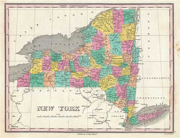
New York.
sold
- Digital Map Information
- Suitable for large format printing
- DPI: 300
- File Size: 2.67 MB
- File Type: ZIP / TIFF
- ICC color profile embedded
- Delivered instantly via download link
This is an 1828 Anthony Finley map of New York. The map depicts the region from Lake Erie to Vermont, Massachusetts, and Connecticut and from Ontario to Pennsylvania and New Jersey, including Long Island and Lake Ontario, all ... (more details)
Rare city planning map of Shanghai with mansucript additions of prospective new streets.

Plan of Shanghai Published under Authority of the Municipal Council. 1923
sold
- Digital Map Information
- Suitable for large format printing
- File Size: 46.17 MB
- File Type: ZIP / TIFF
- ICC color profile embedded
- Delivered instantly via download link
An extremely rare and important 1923 large format map of Shanghai issued by the Shanghai Municipal Council. The map is enormous and extends from the Huangpu River westward as far as the Tianshan Road Residential District. It ... (more details)
Rare map of Andover, Massachusetts identifying individual property owners.
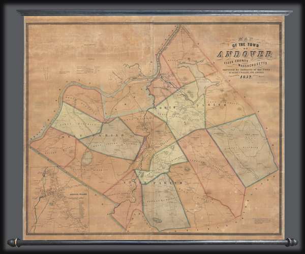
Map of the Town of Andover, Essex County, Massachusetts.
sold
- Digital Map Information
- Suitable for large format printing
- DPI: 300
- File Size: 33.99 MB
- File Type: ZIP / TIFF
- ICC color profile embedded
- Delivered instantly via download link
This is a scarce 1852 Henry F. Walling wall map of the towns of Andover and North Andover, Massachusetts. Like most Walling town maps, the cartographer has taken great pains to identify the homes of individual families and ... (more details)
The coat of arms of the short lived Kingdom of Corsica appears in the lower left corner.

Insula Corsica, Olin Regni Titulo Insignis nunc Genuensis Reipublicae potestati sujecta, juxta reventissimam designationem.
sold
- Digital Map Information
- Suitable for large format printing
- DPI: 300
- File Size: 12.1 MB
- File Type: ZIP / TIFF
- ICC color profile embedded
- Delivered instantly via download link
This is a 1742 Covens and Mortier map of Corsica, France. The map depicts the entirety of the island in fantastic detail, labeling cities, towns, and villages, as well as rivers and mountain ranges. Several major cities are ... (more details)
Rare Czech map of North America with a fascinating Trans-Mississippi based upon the explorations of early fur trappers.
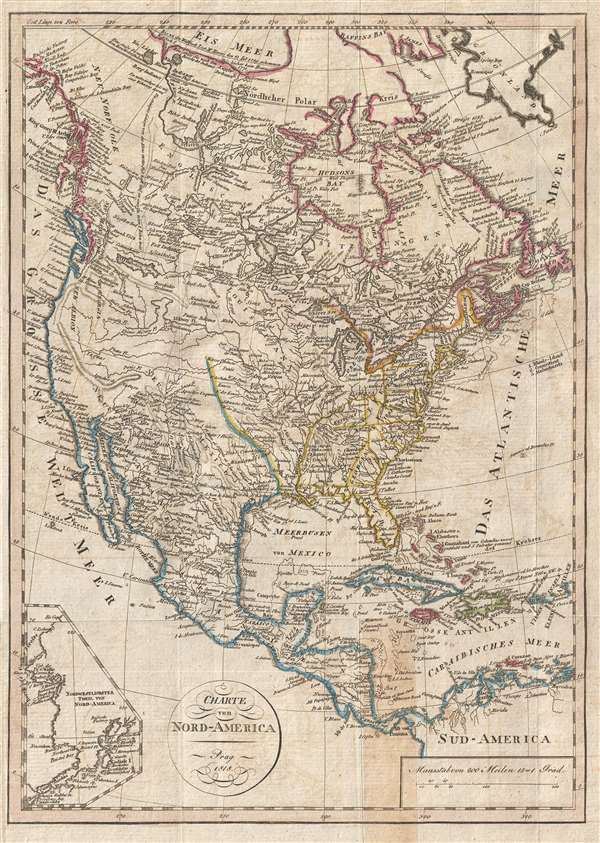
Charte von Nord-America Prag 1818.
sold
- Digital Map Information
- Suitable for large format printing
- DPI: 300
- File Size: 5.35 MB
- File Type: ZIP / TIFF
- ICC color profile embedded
- Delivered instantly via download link
A very unusual, rare, and information dense 1818 Franz Pluth map of North America featuring an inset of Alaska and an unusual speculative mapping of the Trans-Mississippi West. With German text, the map covers all of North ... (more details)
Beautiful map of the Hamptons.

Middle Part of the Southern Coast of Long Island.
sold
- Digital Map Information
- Suitable for large format printing
- File Size: 11.6 MB
- File Type: ZIP / TIFF
- ICC color profile embedded
- Delivered instantly via download link
This is an extraordinary and extremely rare large format 1857 U.S. Coast Survey nautical chart or maritime map of southeastern Long Island, New York. The map depicts part of Suffolk County from Moriches Bay to Napeague ... (more details)
Incredible map of Montauk and Block Island.

Eastern Part of the Southern Coast of Long Island.
sold
- Digital Map Information
- Suitable for large format printing
- File Size: 13.44 MB
- File Type: ZIP / TIFF
- ICC color profile embedded
- Delivered instantly via download link
This is an 1857 U.S. Coast Survey nautical chart or maritime map of Montauk and Block Island, New York. The map depicts the region from Napeague Bay to the sound east of Block Island. Highly detailed, myriad depth ... (more details)
Incredible coastal detail - including the James, York, and Rappahannock Rivers!

U.S. Coast Survey Sketch C Showing the Progress of the Survey in Section No. III from 1843 to 1857.
sold
- Digital Map Information
- Suitable for large format printing
- File Size: 14.26 MB
- File Type: ZIP / TIFF
- ICC color profile embedded
- Delivered instantly via download link
This is an 1857 U.S. Coast Survey nautical chart or maritime map of the Chesapeake Bay. The map depicts the region from Susquehanna, Maryland to the northern Outer Banks in North Carolina and from Richmond and ... (more details)
Illustrates numerous Brooklyn landmarks, including the Brooklyn Academy of Music, Prospect Park, and the Brooklyn Bridge.

Brooklyn 1636 - 1776 / Brooklyn 1865 - Today / Brooklyn Townships
sold
- Digital Map Information
- Suitable for large format printing
- File Size: 3.8 MB
- File Type: ZIP / TIFF
- ICC color profile embedded
- Delivered instantly via download link
These are three Frank Randolph Southard pictorial maps of Brooklyn, New York. Each of the three maps depicts roughly the same geographic area, from Manhattan and the East River to the Atlantic Ocean and from ... (more details)
Early U.S. Coast Survey map of New Jersey.

Sketch B. No. 3 Showing the Triangulation and Geographical Positions in Section No. II From New York City to Cape Henlopen.
sold
- Digital Map Information
- Suitable for large format printing
- DPI: 300
- File Size: 9.98 MB
- File Type: ZIP / TIFF
- ICC color profile embedded
- Delivered instantly via download link
This is an exceptional example of the 1851 U.S. Coast Survey's nautical chart or maritime map for New Jersey and the Delaware Bay. It covers the coast line from New York City south through New Jersey to ... (more details)
Gorgeous map illustrating Fernandina and St. Mary's, Florida.

St. Mary's River and Fernandina Harbor Florida.
sold
- Digital Map Information
- Suitable for large format printing
- File Size: 11.73 MB
- File Type: ZIP / TIFF
- ICC color profile embedded
- Delivered instantly via download link
This is an 1857 U.S. Coast Survey nautical chart or maritime map of St. Mary's River and Fernandina Harbor in northern Florida. The map depicts the winding course of the St. Mary River Delta from St. ... (more details)