
Stunning hand colored map of Central America including Lake Nicaragua.

Partie du Mexique ou de la Nouvelle Espagne Où se trouve l'Audience de Guatimala. Par le Sr. Robert de Vaugondy Fils de Mr. Robert Géogr. ordin. du Roi.
sold
- Digital Map Information
- Suitable for large format printing
- DPI: 300
- File Size: 1.84 MB
- File Type: ZIP / TIFF
- ICC color profile embedded
- Delivered instantly via download link
This is a hand colored 1749 Didier Robert de Vaugondy map of Central America. The map depicts from the Yucatan Peninsula to Panama and from the Pacific Ocean to the Caribbean Sea. The Audience of Mexico ( Audience de Mexique ), Guatimala, Verapaz, Honduras, ... (more details)
Beautiful hand colored map of the Canary Islands archipelago.

Les Isles Canaries. Par le Sr. Robert de Vaugondy Fils de Mr. Robert Geog. ord. du Roi.
sold
- Digital Map Information
- Suitable for large format printing
- DPI: 300
- File Size: 1.24 MB
- File Type: ZIP / TIFF
- ICC color profile embedded
- Delivered instantly via download link
This is a hand colored 1749 Didier Robert de Vaugondy map of the Canary Islands. The map depicts the seven Canary Islands, including Tenerife (Isle de Teneriffe), Fuerteventura (I. de Fortaventure), Gran Canaria (I. Canarie), Lanzarote (I. Lancerotte), La ... (more details)
Gorgeous hand colored map of Hispaniola or Santo Domingo and the Turks and Caicos Islands.

L'Isle St. Domingue. Par le Sr. Robert de Vaugondy, Fils de Mr. Robert Geogr. ordin. du Roi.
sold
- Digital Map Information
- Suitable for large format printing
- DPI: 300
- File Size: 1.46 MB
- File Type: ZIP / TIFF
- ICC color profile embedded
- Delivered instantly via download link
This is a hand colored 1749 Didier Robert de Vaugondy map of the island of Hispaniola or Santo Domingo (Haiti / Dominican Republic). The map depicts the entire island of Hispaniola or Santo Domingo, along with the extreme eastern part of Cuba, the Turks ... (more details)
Map of Iran and Central Asia depicting Isfahan and Kandahar.
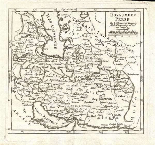
Royaume de Perse. Par le Sr. Robert de Vaugondy, fils de Mr. Robert Geog. du Roi
sold
- Digital Map Information
- Suitable for large format printing
- DPI: 300
- File Size: 1.6 MB
- File Type: ZIP / TIFF
- ICC color profile embedded
- Delivered instantly via download link
This is a 1749 Didier Robert de Vaugondy map of Iran and Central Asia. The map depicts from the Ottoman Empire (Iraq) to the Afghan/Indian border and from the Aral Sea and the Caucasus to the Persian Gulf. The Ottoman Empire (Empire du Turc) and Arabia ... (more details)
Map of northern Spain, including Basque Country, depicting Bilbao and Madrid.
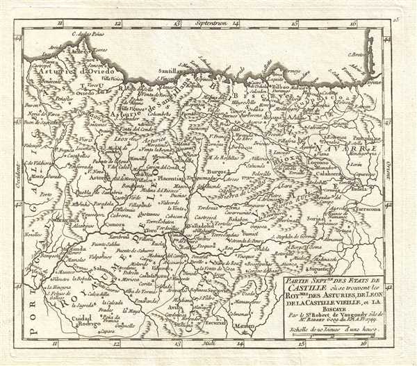
Partie Septentrionale des Etats de Castille où se trouvent les Royaumes des Asturies, de Leon, de la Castille Vieille, et la Biscaye. Par le Sr. Robert de Vaugondy, fils de Mr. Robert Geog. du Roi.
sold
- Digital Map Information
- Suitable for large format printing
- DPI: 300
- File Size: 1.88 MB
- File Type: ZIP / TIFF
- ICC color profile embedded
- Delivered instantly via download link
This is a 1749 Didier Robert de Vaugondy map of Castile and Basque Country, Spain. The map depicts from Galicia and Portugal to Castile and Navarre and from the Bay of Biscay to Castile. Bilbao, the largest city in Basque Country, is situated along the ... (more details)
Map of Aragon and Catalonia, Spain, including Barcelona.

Partie Septentrionale de la Couronne d'Aragon où se trouvent le Royaume d'Aragon et la Principauté de Catalogne. Par le Sr. Robert de Vaugondy, Fils de Mr. Robert Geog. du Roi
sold
- Digital Map Information
- Suitable for large format printing
- DPI: 300
- File Size: 2.18 MB
- File Type: ZIP / TIFF
- ICC color profile embedded
- Delivered instantly via download link
This is a 1749 Didier Robert de Vaugondy map of northern Aragon, Spain. The map depicts from Navarre and Castile to the Mediterranean and from France to Valencia and the Mediterranean. Catalonia (Catalogne) is labeled and dominates the right side of ... (more details)
Map of Navarre, Spain depicting Pamplona and Basque Country.

Royaume de Navarre divisé en six Mérindades. Par le Sr. Robert de Vaugondy, Fils de Mr. Robert. Geog. du Roi.
sold
- Digital Map Information
- Suitable for large format printing
- DPI: 300
- File Size: 2.14 MB
- File Type: ZIP / TIFF
- ICC color profile embedded
- Delivered instantly via download link
This is a 1749 Didier Robert de Vaugondy map of Navarre, Spain. The map depicts from Biscayeto southern France and from the Bay of Biscay and southwestern France to Castile and Aragon. Pamplona, the city famous for Festival of Saint Fermin and the ... (more details)
Map of Chile, depicting Santiago and Valparaiso.

Le Chili. Par le Sr. Robert de Vaugondy, Fils de Mr. Robert Geogr. ord. du Roi.
sold
- Digital Map Information
- Suitable for large format printing
- DPI: 300
- File Size: 1.48 MB
- File Type: ZIP / TIFF
- ICC color profile embedded
- Delivered instantly via download link
This is a 1749 Didier Robert de Vaugondy map of Chile (Imperial Chili). The map depicts from Chile and Paraguay to the Chilean-Argentine border. Chile is depicted in detail; numerous rivers are labeled. Santiago (St. Yago) and Valparaiso are also ... (more details)
Map of Argentina, depicting Tierra del Fuego and the Falkand Islands / Islas Malvinas.

Les Terres Magellaniques. Par le Sr. Robert de Vaugondy, Fils de Mr. Robert Geogr. ord. du Roi.
sold
- Digital Map Information
- Suitable for large format printing
- DPI: 300
- File Size: 1.43 MB
- File Type: ZIP / TIFF
- ICC color profile embedded
- Delivered instantly via download link
This is a 1749 Didier Robert de Vaugondy map of Argentina and Chile (Chili). The map depicts from Paraguay to Tierra del Fuego and from the Pacific Ocean to the Atlantic Ocean. The Falkland Islands, also known as the Islas Malvinas, are partially ... (more details)
Map of Paraguy and Uruguay, depicting the mysterious Laguna de los Xaraies.
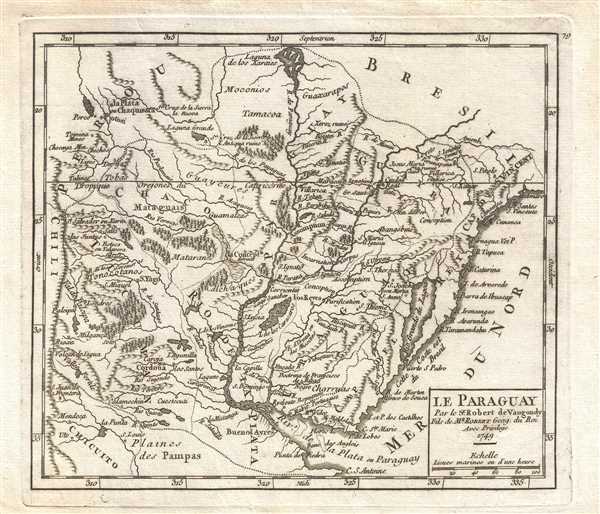
Le Paraguay. Par le Sr. Robert de Vaugondy, Fils de Mr. Robert Geog. du Roi.
sold
- Digital Map Information
- Suitable for large format printing
- DPI: 300
- File Size: 1.71 MB
- File Type: ZIP / TIFF
- ICC color profile embedded
- Delivered instantly via download link
This is a 1749 Didier Robert de Vaugondy map of Paraguay. The map depicts from the border between Paraguay, Brazil, and Peru to Rio de la Plata and Uruguay (Uraguay) and from Chili to the Atlantic Ocean. The Laguna de los Xaraies is labeled along ... (more details)
Map of Brazil, depicting Sao Paulo.

Terre de Sainte Croix, nommée à present Bresil. Par le Sr. Robert de Vaugondy, Fils de Mr. Robert Geog. du Roi.
sold
- Digital Map Information
- Suitable for large format printing
- DPI: 300
- File Size: 1.65 MB
- File Type: ZIP / TIFF
- ICC color profile embedded
- Delivered instantly via download link
This is a 1749 Didier Robert de Vaugondy map of the Atlantic coast of Brazil. The map depicts from the Equator to Sao Paulo (S. Paulo) and from the 'unknown interior of the country' ( L'Interieur du Pays est inconnu ) to the Atlantic Ocean. ... (more details)
Map of Spain, depicting Santiago de Compostela, the destination of the Way of St. James
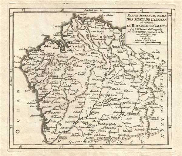
Partie Septentrionale des Etats de Castille où se trouve le Royaume de Gallice. Par le Sr. Robert de Vaugondy. Fils de Mr. Robert Geogr. ord. du Roi.
sold
- Digital Map Information
- Suitable for large format printing
- DPI: 300
- File Size: 1.56 MB
- File Type: ZIP / TIFF
- ICC color profile embedded
- Delivered instantly via download link
This is a 1749 Didier Robert de Vaugondy map of Galicia in northwestern Spain including Santiago de Compostela (S. Iago de Compostella). The map depicts from the Atlantic Ocean to Asturias (Asturies) and the Kingdom of León and from the ... (more details)
Striking thermal map of North America illustrating Gilpin's climate theories.
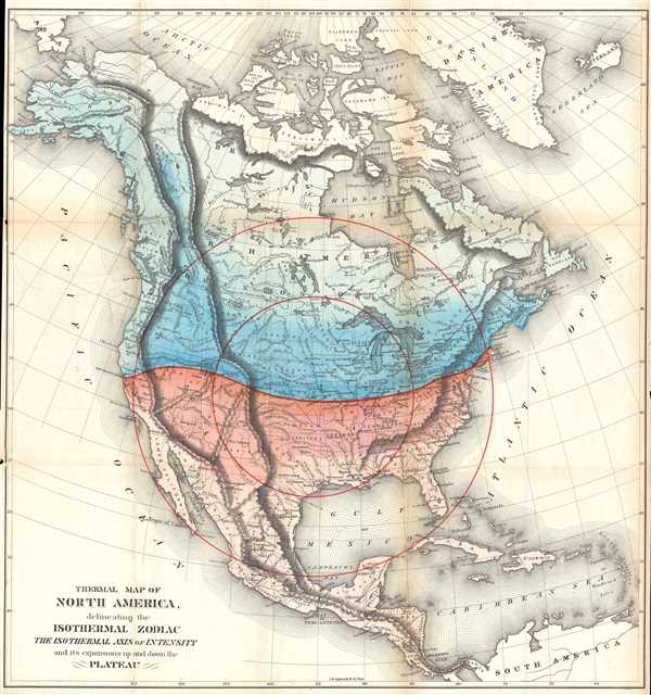
Thermal Map of North America, delineating the Isothermal Zodiac the Isothermal Axis of Intensity and its expansions up and down the Plateau.
sold
- Digital Map Information
- Suitable for large format printing
- File Size: 15.55 MB
- File Type: ZIP / TIFF
- ICC color profile embedded
- Delivered instantly via download link
This is an 1873 William Gilpin geological map of North and Central America. The map depicts from the Arctic Ocean to South America and from the Pacific to the Atlantic. This map is the third map from Gilpin's book Mission of the North ... (more details)
Charming map of Oxford University, identifying numerous colleges and their coats of arms.

City and University of Oxford.
sold
- Digital Map Information
- Suitable for large format printing
- DPI: 300
- File Size: 2.73 MB
- File Type: ZIP / TIFF
- ICC color profile embedded
- Delivered instantly via download link
This is an 1837 Thomas Moule map or city plan of Oxford, England. Stretching from the observatory on Woodstock Road to the River Isis and the Charwell River and from the Oxford Canal to Magdalen Bridge, this map depicts both the city ... (more details)
Detailed climate map of the Philippines illustrating rainfall.
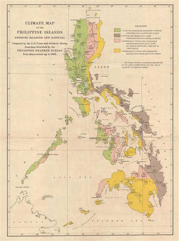
Climate Map of the Philippine Islands showing Seasons and Rainfall.
sold
- Digital Map Information
- Suitable for large format printing
- File Size: 2.34 MB
- File Type: ZIP / TIFF
- ICC color profile embedded
- Delivered instantly via download link
This is a 1925 U.S. Coast and Geodetic Survey climate map of the Philippines. The map depicts the entire Philippine Archipelago from the Babuyan Islands and Luzon to Mindanao, the Sulu Archipelago, and the Celebes Sea; and from the ... (more details)
Important Charles Sargent arboreal map of North American forests.

Map Showing the Natural Divisions of the North American Forests. Exclusive of Mexico.
sold
- Digital Map Information
- Suitable for large format printing
- File Size: 11.33 MB
- File Type: ZIP / TIFF
- ICC color profile embedded
- Delivered instantly via download link
This is an 1884 Charles Sprague Sargent arboreal thematic map of North America. The map depicts the continent of North America from the Arctic Ocean, Alaska, and Canada south to Mexico and Central America, as well as the extreme ... (more details)
Important early view of Salt Lake City, Utah.
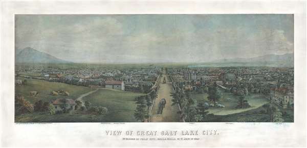
View of Great Salt Lake City.
sold
- Digital Map Information
- Suitable for large format printing
- File Size: 54.36 MB
- File Type: ZIP / TIFF
- ICC color profile embedded
- Delivered instantly via download link
This is a very rare 1867 Christian Inger view of Salt Lake City, Utah. The view illustrates Salt Lake City looking down Main Street as it appeared roughly 20 years following the arrival of the Mormons. The development, in such ... (more details)
Rare, incredibly detailed, trilingual 1936 edition of the China Postal Atlas.
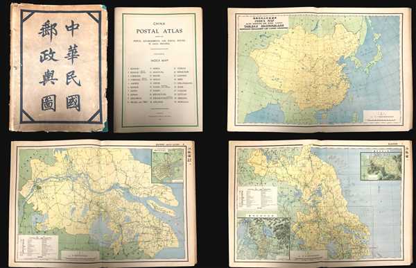
China Postal Atlas Showing the Postal Establishments and Postal Routes in Each Province.
sold
A scarce example of the 1936 edition of the official Chinese Postal Atlas. Compiled by Charles Jacot-Guillarmod, this atlas contains 31 maps, including an index, covering all of China in considerable detail. Most of the maps ... (more details)
One of the earliest American maps to extend to the Mississippi. Illustrates ealry postal routes and the Connecticut Western Reserve.
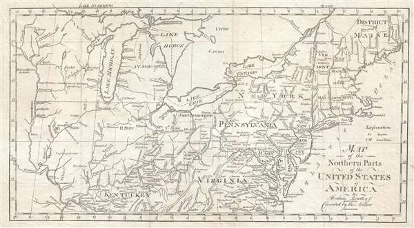
Map of the Northern Pars of the United States of America. By Abraham Bradley Jr. Corrected by the Author.
sold
- Digital Map Information
- Suitable for large format printing
- DPI: 300
- File Size: 3.83 MB
- File Type: ZIP / TIFF
- ICC color profile embedded
- Delivered instantly via download link
This is a scarce and significant early postal route map of the northern parts of the United States illustrating postal routes and the five Jeffersonian states proposed by the Ordinance of 1789. The present example is the ... (more details)
Rare Czech map of North America with a fascinating TransMississippi based upon early fur trappers.
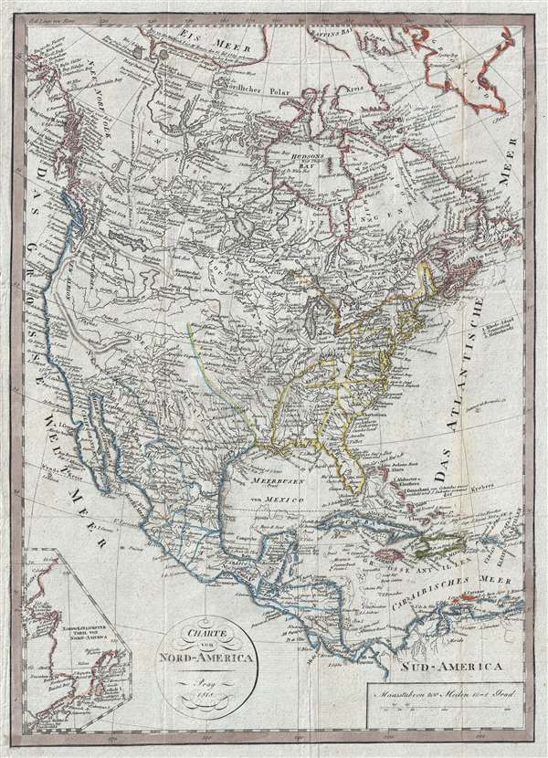
Charte von Nord-America Prag 1818.
sold
- Digital Map Information
- Suitable for large format printing
- DPI: 300
- File Size: 8.18 MB
- File Type: ZIP / TIFF
- ICC color profile embedded
- Delivered instantly via download link
A very unusual, rare, and information dense 1818 Franz Pluth map of North America featuring an inset of Alaska and an unusual speculative mapping of the Transmississippi West. With German text, the map covers all of ... (more details)